
Brian D
-
Posts
2,219 -
Joined
-
Last visited
Content Type
Profiles
Blogs
Forums
American Weather
Media Demo
Store
Gallery
Posts posted by Brian D
-
-
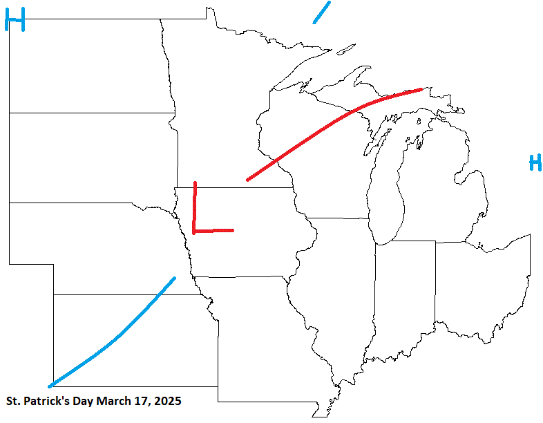
On St Patrick's day this year, it's looking stormy. Typical March system. The second half of March looks like good storm potential into the early days of April.
-
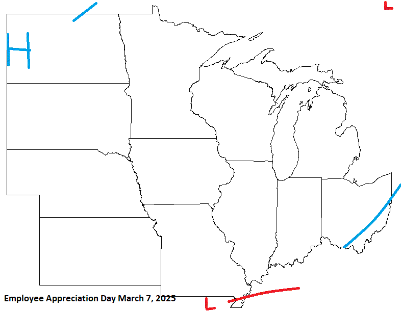
Next is Employee Appreciation Day on March 7. Looks like rather chilly wx for early March. Watch for possible energy affecting the S sub. Any LES will be subject to ice conditions, which could be robust. We'll see.
-
Extreme cold warning in effect starting later this evening thru Tues am. Wind chills down to -45 or so on NW winds. Midnight high of 16 with temps hovering around 0-5 for the aftrn high here in town before the drop continues. Inland areas should stay just below zero for the aftrn.
-
The last pleasant day for a few days. Going to be a brutal shot, but at least it doesn't last for a whole week. 1-3 day shots are not too bad. Still tough tho.
-
Looking at Duluth arpt siting data HOMR, it looks like snow is reported from the NWS office which is about a mile WSW of the arpt. I do know they put up a request for I-Falls arpt this past summer for a snow measuring contractor. MSP arpt has had their Met crew taking measurements since 2020. Prior to that, it looks like they've had a contractor on/around the aprt. As for T snow depth, DLH does report that as seen in their F-6 form, as well as I-Falls, and MSP along with others in the area that take snow readings. (Not co-ops tho)
-
Kick in the shorts come Sun n Mon. Highs in the -10's with -20 to -30 lows. Might even get a little colder at sunrise if winds are dead calm. Shoreline will be -sd's for highs with -10's in the am. Just for perspective, record lows are in the -40's, and low max in the mid/upper -10's for interior NE MN this time of year. Although I-Falls does have a -28 high on the 19th (this Sun), second only to -29 earlier in the month. Sure we won't get that bad.

-
 3
3
-
-
Ice formation as of Jan 12. And with the current pattern through the month, this should fill in nicely. We could be looking at a high ice year.


-
1
-
 1
1
-
-
-10's inland to -sd's along the shore this morning. Wind chills in the -30's away from the Lake. Looking, and feeling like winter now.
-
2
-
-
6 hours ago, Brian D said:
3.5" imby so far this morning. 4-7" being reported at other locales. Still snowing, so should see some bigger totals later today. Nice to see white otg.
")
Ended with 4". Big fail up N. Dry air put the brakes on bigger totals. Lake never really got involved either. Surface to 850 winds just too weak. Anything that may have developed probably stayed out there, and drifted up into CAN with the upper flow from the SW.
EDIT: NWS DLH just emailed me back. They don't think dry air was too much, but the wind velocities were too weak to push anything onshore, or any orographic lifting. He did suggest snowboards on buoys. LOL
-
 1
1
-
-
3.5" imby so far this morning. 4-7" being reported at other locales. Still snowing, so should see some bigger totals later today. Nice to see white otg.
-
2
-
-
4 hours ago, Brian D said:
About time we get something substantial. But we'll see how it ends. This will be better than that last clipper they overcast (got egg on the face). Last one was "High & Dry" (old Def Leppard). Pressure too high, and air too dry. This one is much better for lower pressure for better lift, and not as much dry air to contend with. Should be a good overnight hit.

Pm update showing a slight increase in projected totals. With no dry air inhibiting the snow this time, could end on the higher side. Here's to hoping so.
WSW issued for the areas to my N. WWA for the rest of us.

-
1
-
-
2 hours ago, OrdIowPitMsp said:
Tonight’s Clipper is trending towards a dusting for my backyard. Near miss to the north. Northern Minnesota is the place to be.
GFS looking quite dry for most of the subforum.
About time we get something substantial. But we'll see how it ends. This will be better than that last clipper they overcast (got egg on the face). Last one was "High & Dry" (old Def Leppard). Pressure too high, and air too dry. This one is much better for lower pressure for better lift, and not as much dry air to contend with. Should be a good overnight hit.
-
2
-
-
That light snow stayed really light. About 0.1" as the band fades to the E. Well, here's hoping for a little more this weekend.
-
1
-
-
2 hours ago, Malacka11 said:
Is it at all normal for you to have bare ground going into mid-January?
Low chance that it happens in any given year. I usually have a least a few inches otg by now. Inland still has some crusty snow.
-
1
-
-
Back during the summer I worked up datasets for the 4 major cities of our sub comparing urban to rural. Thought I'd repost those with 2024 added. It was a very warm year.


-
1
-
2
-
-
Looks like a quick 0.5-1" of snow this aftrn with a front moving through. Hopefully that weekend clipper will give me a couple more. Any Lake bands would be welcome as winds turn E to NE. Very brown still after the warmer end to Dec, along with the rain we had here in town.
-
Add in the Max & Min monthly precip.

.thumb.gif.f46717208becc78442d01c776e30ac46.gif)

.thumb.gif.1ff41c10b854955e46e15e24c5953641.gif)
-
1
-
-
This will be the Max precip.

.thumb.gif.1c0fd2a7d6c9decd3c14e17f359073c7.gif)

.thumb.gif.a0942de7a8d91e8c5ee7a07c06e79bf4.gif)


-
The last for temps is Min.

.thumb.gif.1987aeadf5f8d51801634c27f3f79f73.gif)

.thumb.gif.34dedabaf4556cc18bd23c381548768c.gif)


.thumb.gif.5afb7d71dee692a45c50fdd82bc5303d.gif)
-
Next is Lmax.

.thumb.gif.1792eaebcb70c6dc011a78b1bb828e00.gif)

.thumb.gif.c6579d7f3d4f1f95041220e193148a35.gif)


.thumb.gif.6c4a2c2b318dfd4aa033672846e62df2.gif)
-
Next is the Hmin metric.

.thumb.gif.048c69f1421252357da3976b9b3e2963.gif)

.thumb.gif.7c7c9796a9fb690fe90b68a60b7acb4b.gif)


.thumb.gif.254153c0a989ba52eae8da5aee1d6fa5.gif)
-
1
-
-
Finished my work up of the extremes from 20 long period (mid 1870's & earlier) stations in our sub region. I'll be posting Max, Hmin, Lmax, Min, and Max precip metrics. I also may add high/low avg metrics, and snowfall in the future. I'll also will be working on those stations that have start data from the late 1870's into the mid 1890's. There are quite a few of those, as well, with most of them having starts in the early 1890's, so I'll probably start the graphs with the 1890's decade with them. And they are not co-op sites.
Lets start off with the Max temps. First graph will be the 20 stations combined, followed by the W & E split for the top 5 & #1 and then a list of the most extreme daily temps in the records (you may need to click the image to get a good look). Then followed by the monthly, with the W & E split. The W & E are pretty similar, but you will notice some difference. All data is updated thru 2024.

.thumb.gif.c4aab926909fc8acf2f8946fc4d179a5.gif)

.thumb.gif.8201dbb7017729589d2292569300e0b4.gif)


.thumb.gif.9a9e418e1b7d906386a30771b0083baa.gif)
-
2
-
-
Early data in for Dec. Chalk up another warm one. As for the Annual data, currently running 4th warmest, just a few hundredths behind 1998. Decent chance it slips into 3rd after all datasets have reported. 5 & 10 yr trend charts shown respectively.


-
-10's to -sd's this morning with sd's inland to around 10 on the lakeshore this aftrn. Wind chills away from the lake running -20 to -30. Pretty much the same wx for the next few days. All the action staying S for now, so enjoy it while the potential lasts.


.gif.a4d7dae62b2006c671a88eb918508f4f.gif)
.gif.3f6098231beddac3d832913005aa6078.gif)
.gif.69fd3e18db62c6b88a0b8a9ae07d8c1d.gif)
.gif.ebe5e7df41b8a07fad412da7c679e1b6.gif)


.gif.f28cebaef4d8a7a52e73ae9efefa8d2b.gif)
.gif.5bd3690eb4622e01f9c8c9775bc1187d.gif)

.gif.e3d72462f95322e78686a53c34c794b3.gif)
.gif.17d558661776fef4245234e842a167b7.gif)
.gif.2ed018d351ef721e7d87e4a17abac181.gif)

.gif.9c447989bc7435637057c301c518ba0a.gif)
.gif.5011782a3c6a76255c5a771088ae894f.gif)
.gif.05f14498474b1b46811fe97af3b821a8.gif)

.gif.ae22b84978d6a96335ed32f3c5d5cbde.gif)

.gif.0b4a68895af476d856e676b700403bb4.gif)
.gif.f90e8e78faf7db2c318c244fc5d31fd7.gif)

.gif.a0709d58915429d2cc19aac1a9cc5e83.gif)
Holiday Forecasts 2025
in Lakes/Ohio Valley
Posted
On April Fool's Day, I'm anticipating a system moving through the Lakes, and possible snow up my way. Another typical Spring storm potential.