
Brian D
-
Posts
1,808 -
Joined
-
Last visited
Content Type
Profiles
Blogs
Forums
American Weather
Media Demo
Store
Gallery
Posts posted by Brian D
-
-
16 minutes ago, TheClimateChanger said:
Here's Lansing, Michigan snowfall records [earlier years at East Lansing, Michigan], excluding a few years with excessive missing data:
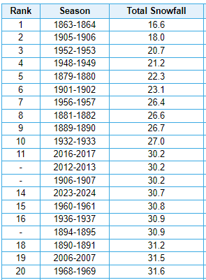
Maybe a bit questionable that the very first year with data ranks as lowest. Looking at the monthly data, that looks mostly a function of the fact that precipitation was 25-50 percent of modern norms for the bulk of the cold season.
The daily data shown at MRCC from Oct 1863-April 1864 is robust. Nothing missing. 16.6" is the final value for the season.
-
2 hours ago, OrdIowPitMsp said:
Absolutely puking snow. Roads are completely covered. Building up that late March snowpack. This storm has been awesome. Finally kicked the doldrums of nothingness we’ve been in for months.
10" yesterday imby, and we got a little rn last night before the band turned to snow. A couple inches of powder, and snowin good atm.
") Told my grandson a couple months ago, watch, it'll snow a lot in the Spring if we don't get much over Winter.
Told my grandson a couple months ago, watch, it'll snow a lot in the Spring if we don't get much over Winter.
Lookin at totals from yesterday, a pretty good swath of 12-17" along the North Shore. Add today's snow, when all said n done, I'd say a pretty good storm.
-
 1
1
-
-
Heavier snow band blossomed right over the head of the lake with moisture feed coming in from the S/SW. Radar looks anemic, then the lake air interaction causes a blow up of snow. That's enhancement for ya.
-
1
-
-
Radar really chunky right now. Heavier band moved through, and could be a bit more heavier stuff with what I see coming up from the Twin Cities around sunset or so. Unless the temps rise enough for a mix/rn scenario.
-
5 hours ago, Brian D said:
7-9" along the shore here, and yes, heavy, wet stuff. Forecast has snow to rain during the night here then transition back to light snow later tomorrow. Looks like some heavier bands are working their way north towards my area. Should be here in a couple hours.
Forecast looks ok so far. I think we'll hit min guidance, but epic fail on winds. Gusts to 25 about it.
With 7" imby this morning, another 3"+ has accum since then with a a good size band heading my way again in a couple hrs.
-
5 hours ago, OrdIowPitMsp said:
8.2” storm total as of 1am. Transitioning over to liquid precipitation now.
2 hours ago, OrdIowPitMsp said:This is pure heart attack snow. Compacting into sludge and slush very quickly on paved surfaces.
This is our biggest snowstorm of the year and I’m even happier about all the much needed moisture we are receiving.
7-9" along the shore here, and yes, heavy, wet stuff. Forecast has snow to rain during the night here then transition back to light snow later tomorrow. Looks like some heavier bands are working their way north towards my area. Should be here in a couple hours.
Forecast looks ok so far. I think we'll hit min guidance, but epic fail on winds. Gusts to 25 about it.
-
3
-
-
52 minutes ago, OrdIowPitMsp said:
Sun starting to set, heavy returns incoming upstream. This is where we start stacking flake efficiently. It’s been steadily snowing all afternoon but probably only 2.5” accumulation. It’s been an awesome day of watching the snowfall with my kid.
Have about the same here, and stronger returns are starting to move my way.
-
2
-
-
Lighter snows so far, have now turned into a steady snow. Grass is getting covered. Winds still light. Snow totals have been scaled back by 1-2", 12-18" instead of 14-19", and winds have been as well. Expecting up to 45 mph, instead of 50-55 mph. That's ok, as less of a chance for power outages. So we'll see how well the new forecast pans.
-
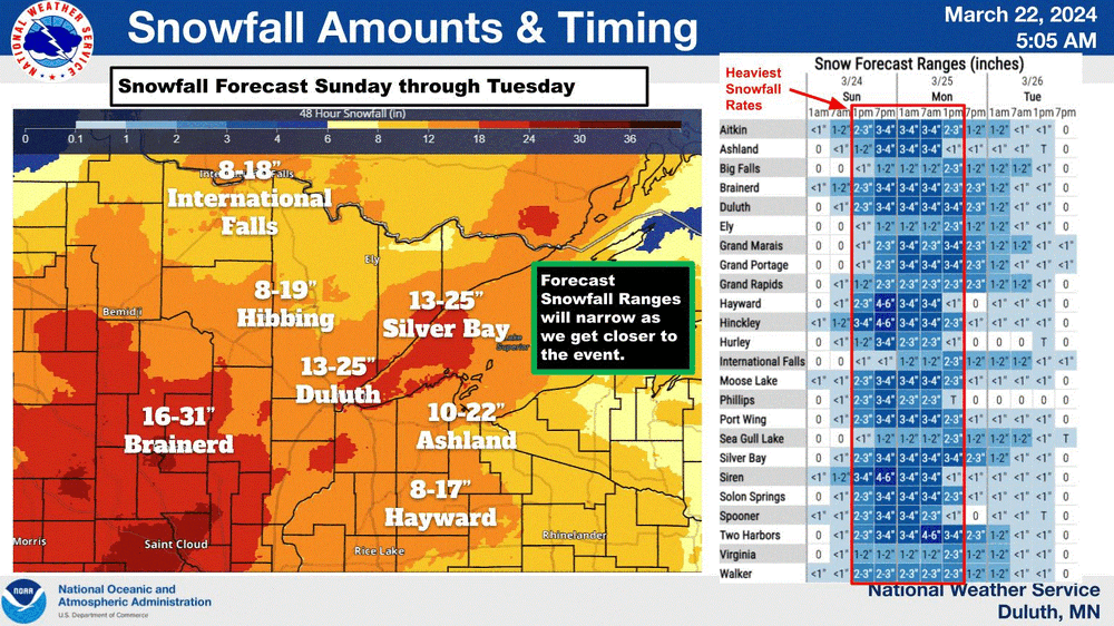
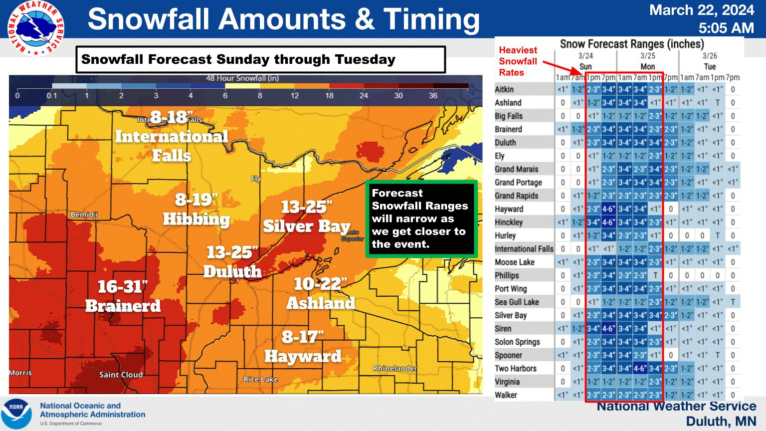
Latest for my neck of the woods. Blizzard warning issued already along North Shore. A mix is possible Monday aftrn, and winds should start to slackin then too, as LP gets closer. Now lets see if this big dog produces.
Southern Lake-Southern Cook-
Including the cities of Two Harbors, Silver Bay, and Grand Marais
335 AM CDT Sat Mar 23 2024

...BLIZZARD WARNING IN EFFECT FROM 1 PM SUNDAY TO 7 PM CDT
TUESDAY...

* WHAT...Blizzard conditions expected. Total snow accumulations
  of 14 to 19 inches and ice accumulations of around two tenths
  of an inch. Winds gusting as high as 55 mph.
-
2
-
-
NWS DLH putting up their storyboard this morning for the potential next Monday. Basically a month's worth of snow in one shot for most of MN, and N WI. And for some, could be a top 5 ending to the month.
-
5
-
-
6 hours ago, michsnowfreak said:
1931-32 was definitely warmer for the southern lakes and Midwest, but I think for the upper Midwest 2023-24 was a bit warmer.
Yeah, this last season was flipped from then.
-
1
-
-
9 minutes ago, hawkeye_wx said:
Three days ago the Euro was consistently showing 2-3" of rain across eastern Iowa from the upcoming big storm. This is what it has devolved into.
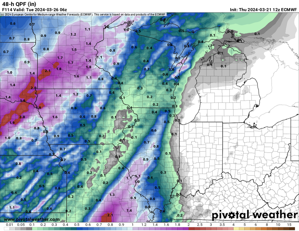
Looks like your being dry slotted now. Well, I say "Don't count your chicks before they hatch". Models, and reality are 2 separate things.
-
MSP could end up with a top 5 snowiest March if the 2 (possibly 3) systems put out decently by Easter. If not MSP, some of the other stns across S MN sure could.
40.0 - 1951
37.1 - 1965
36.8 - 1985
29.9 - 1917
25.6 - 1940
-
Forecast discussion out of NWS DLH. Expecting a good ol' fashioned blizzard here on the North Shore.
The main feature of the forecast is the expansive Colorado Low
that is progged to arrive late Sunday and linger through early
Wednesday. Latest guidance has pushed the arrival back several
hours, and maybe decreased the overall QPF from the system a
bit, but this still appears like it will be a significant
system with long periods of heavy QPF in a cold air mass with
strong northeast winds off of Lake Superior. I would expect
blizzard conditions to develop along the North Shore with winds
gusting to 45 to 50 mph in heavy snow. In terms of ensemble
spread, the floor or minimum amounts of snow expected with this
system are quite high at 6 to 9" over the most populated areas
of our forecast area, the ceiling or maximum amount of snowfall
expected are also quite high with over 2 feet possible (some
locations may approach 30")!
-
3
-
-
On 3/19/2024 at 12:34 PM, Chicago Storm said:
Anyone notice the Euro change that was made?
It still comes out earlier even with the DST change.They change there clocks over there at the end of March. So after Easter, they should be in sync with others.
-
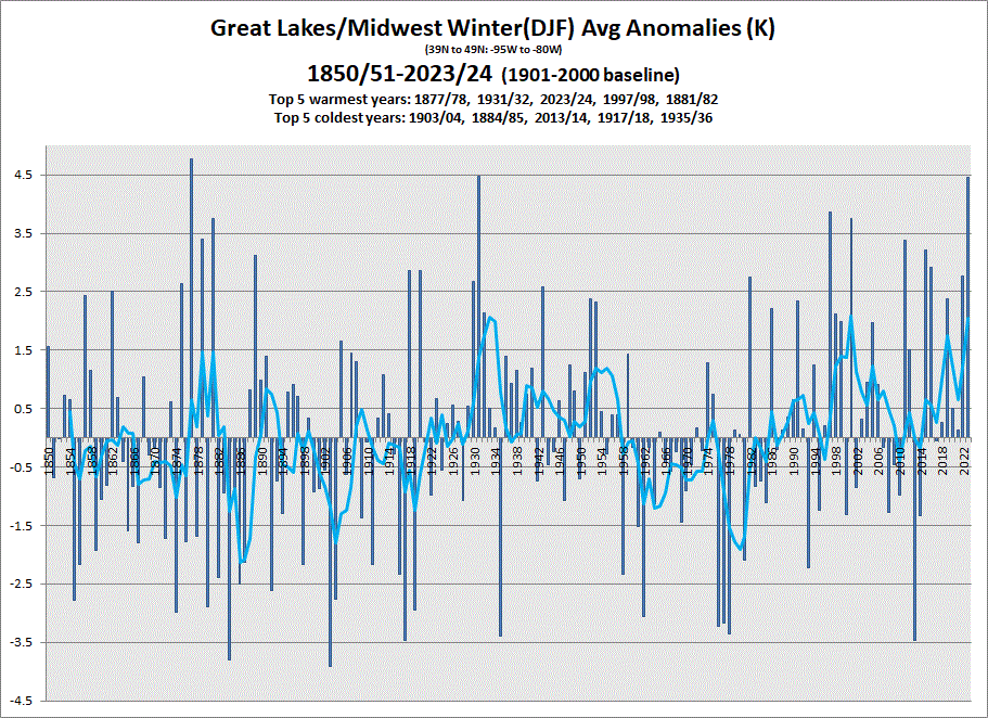
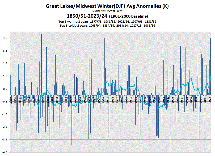
As for Winter 2023/24, it's currently 3rd by the slimmest of margins behind 1931/32. 1931/32 (4.479) & 2023/24 (4.459*). Once all Feb data comes in, we'll see how that goes.
5 & 10 year trend charts shown respectively.
-
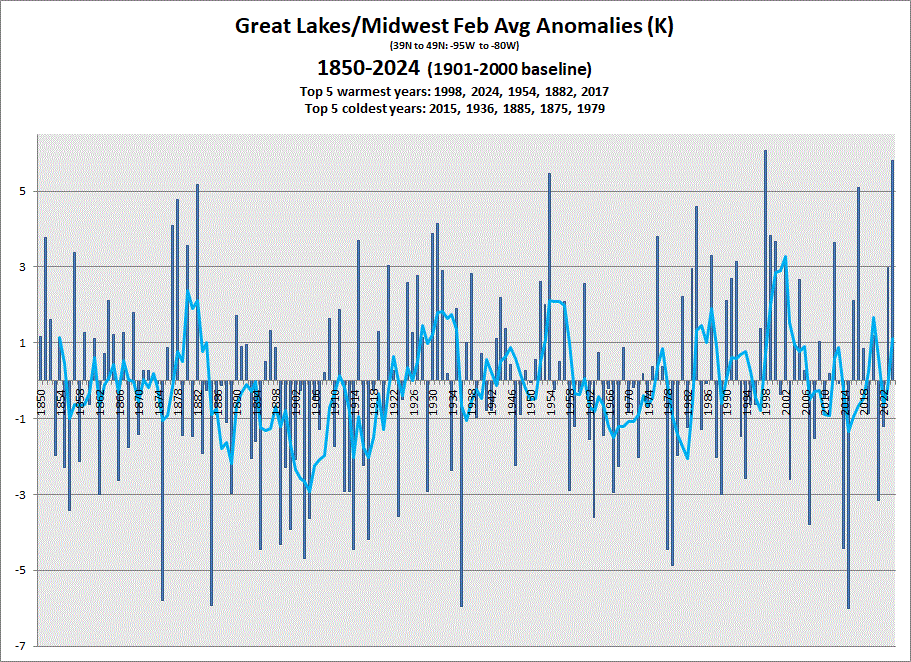
It's the first day of Spring, so I thought it would be good to wrap up Winter data. Some data has yet to come in, but that is nothing unusual. Agencies report when they report.
Feb 2024 is currently running in 2nd behind 1998 by a couple tenths. 1998 (6.074) & 2024 (5.803*) This will change when all data comes in later. How much is yet to be seen.
5 & 10 year trend charts shown respectively.
-
3 hours ago, SchaumburgStormer said:
You guys can keep it. Once we get that first hit of spring my "snow weenie switch" turns off.
The way I see it, when those legs spread.....GAME ON!

-
 2
2
-
-
1 hour ago, Stebo said:
Its cold out there. I hope this does not impact the fruit industry in this state.
A longer stretch of a false Spring, followed by wintry wx can cause serious damage. Wait and see I guess.
-
On 2/7/2024 at 2:11 PM, Brian D said:
My forecast for St. Patty's day this year looks like CA system moving through the N with potential energy affecting the S sub.
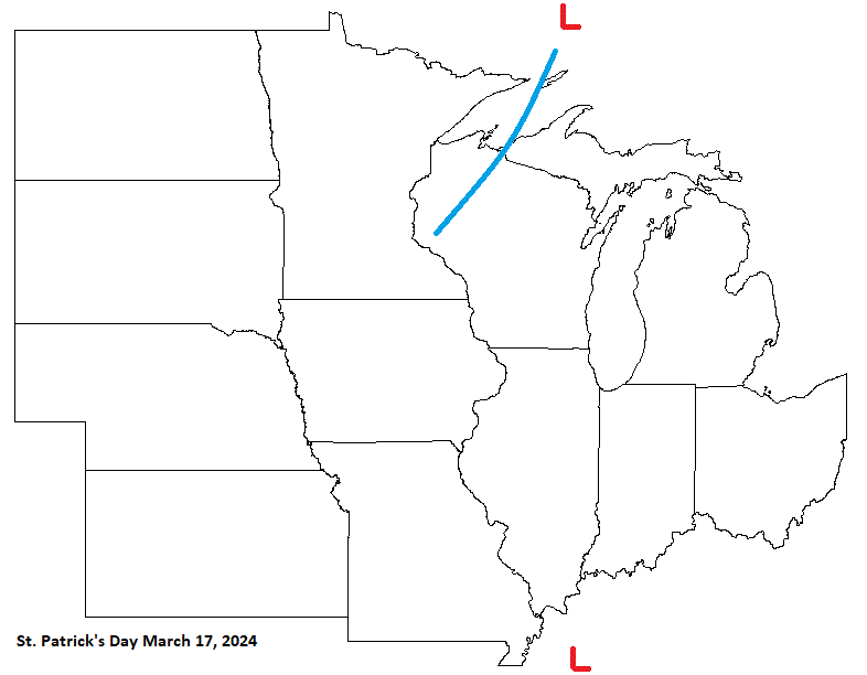
Decent forecast, but the energy in the S is a bit more south, and the timing is off by a day.
-
A windy aftrn with snow showers. Chilly wx on the doorstep, but nothing too cold. Pretty seasonable stuff.
-
On 3/13/2024 at 7:16 AM, michsnowfreak said:
The cold bias was worse this winter than normal. And last summer the extended had a heat bias. And we all know about the precip "clown maps". Always good to repeatedly remind yourself the LR is a guide, NOT a forecast.
Yeah, LR is good to see potential pattern development, not temps/storm intensities, etc.
-
1
-
-
On 3/12/2024 at 2:58 PM, michsnowfreak said:
Using 1970s winters as a baseline has been popular for years and will continue to be. When you use what is for most the harshest decade of winters on record as a baseline for "average", make increases in temps and (for some) decreases in snow more eye popping. The ever-popular "since 1970" will still be popular, but now that we have hit a nice round number of 50 years since 1974-75, that too should increase in popularity (especially we can add the last 2 very mild winters, and lop off the milder, lower snow seasons of '71-73). Lets face it, including the many mild and terrible snow seasons of the 1930s-50s would be a real buzzkill, so just start in the 1970s!
I verified the data for Detroit. Whats interesting is Mar snowfall did decrease from 7.4" to 5.5" (a ~25% decrease) but Feb snow INCREASED from 6.7" to 16.2" (a ~140% increase
). December saw a sharp decrease. Whats funny though is the annual snowfall remained the same to the tenth of an inch (44.9" to 44.9"). The previous 50 years (1924-1973) saw annual snowfall DECREASE by 6.6" & avg winter temps rise 1.4F.
Its all about how you make the graph work for you.
~If I look at the change in the last 50 years of Detroit winters, they have warmed 4.9F and annual snowfall has remained exactly the same (heavier mid-winter and lighter at the beginning and ends of the season).
~However, if I look at the change the last 100 years, the winters have warmed just 1.2F and annual snowfall has increased a whopping 13.3". It goes without saying that those puny mid-20th century winters hurt.
~If I look at the entire period of record, 150 years, Detroit winters have warmed 2.0F & annual snowfall has increased 0.6".
ERA5 data is correct up my way, but I also know how to play "Reindeer Games" too.
But of course my new name would be "Rudolph" now. 
-
1
-
-
Been really mellow wx wise my way, and fire danger is on the rise if we don't get a good rain/snow soon.
-
1
-

March 2024 General Discussion
in Lakes/Ohio Valley
Posted
Snowing really good now. Radar showing increasing dbz along the North Shore.")