
Brian D
-
Posts
1,747 -
Joined
-
Last visited
Content Type
Profiles
Blogs
Forums
American Weather
Media Demo
Store
Gallery
Posts posted by Brian D
-
-
Frost advisory for inland NE MN this morning. Got down to 30-35. Very nice day on tap with mild temps ahead of the next front pushing through this weekend. MN fishing opener today, so fishing wx looks great! Temps running upper 60's-low 70's with 70's tomorrow. Cooler by the Lake as usual.
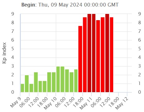
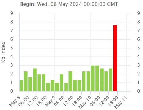
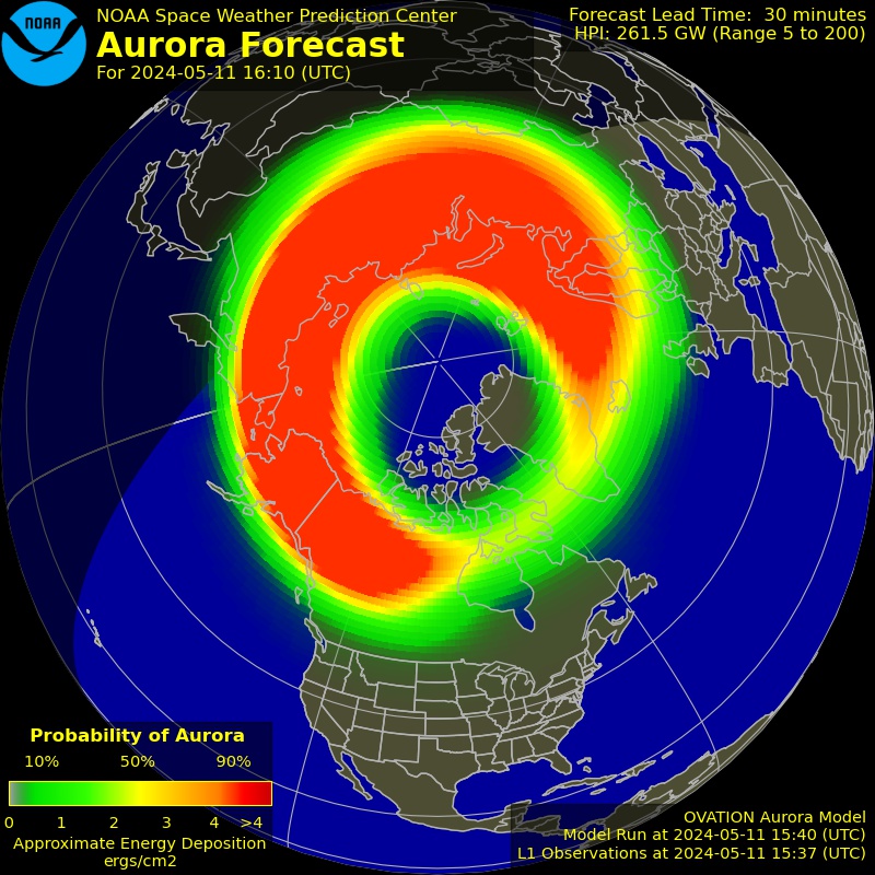
Kp index still strong, with aurora too. Hopefully it will last into tonight for another great show.
-
 1
1
-
-
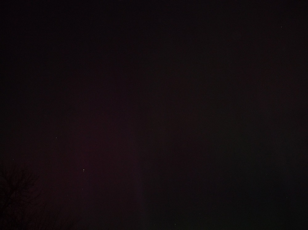
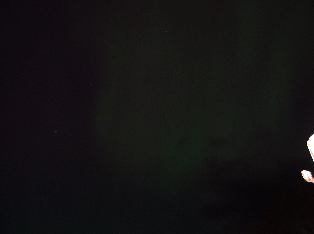
It's possible that the stronger band may have been more S of me. Usually I have the stronger bands up here on regular events that are brighter than this one tonight. Currently, as of 10:45, they are pretty faint now. Love the multi-color mix.
")
-
That's what they look like up here in TH, too. The entire sky, except an area to the S of me is full of green, reddish, pinkish, purplish mix. But they are softer in intensity than the pics above.
Tried my digital camera, but they didn't turn out that great. I tried!

-
2
-
-
Get the latest here for solar wx.
-
Still got some stms in the area, so currently iffy to start until they move off. Another 1/2 -1 hr before dark enough to see anything.
-
Game on.
-
1
-
-
Temps chilly this morning with 28 at the TH arpt, and 32 in town. Frost warnings this morning here, with freeze warnings over N WI. NWS DLH just started issuing these statements up here on May 7, as growing season starts.
-
4 hours ago, King James said:
Regardless, the grid is going down at some point soon, by hook or by crook. Hope all my weather friends have fresh water, canned food, candles, batteries, and God.
Goodluck friend .
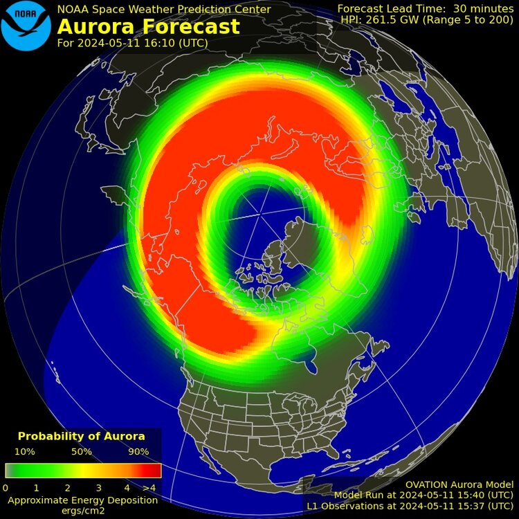
Grid instability is a possibility with this event. I've seen aurora cover 2/3 of the sky around here when I was younger, and different colors from green, red, and even purple. The lights stayed on then, but you never know. They're just giving estimates on strength of hits, and some have fizzled, and others were a total surprise. If you start having higher end X-flares with halo CME's that start combining, then we are in big trouble. Start brushing up on your Mad Max movies.
-
7 hours ago, SolidIcewx said:
That sunspot is a beast. 5 CMEs in the past few days. The next couple days can’t go fast enough so it turns out of our direction. July 2012 we missed a massive almost carrington style solar flare missed earth by 3 days
Yeah, it looks like some of the first CME's are going to combine as they hit us, with more behind allowing for an extended event with auroras this weekend. Forecast looks decent, so should be clear enough around here tonight. Looks like I might have to pull an all-nighter. I don't have a smartphone, but I do have a digital camera, so will try and get some pics. I think it has video, too, but never have used that function. Might try that, too.
-
Mid 40's, and raining this morning. Line of rain moved in from the S, training in from the SE. Looks like a wet one through tonight.
Update: rain moved N, and looks like stms popping to my S. Should see more action later today. Would be nice to have some thunder.
-
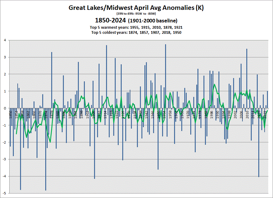
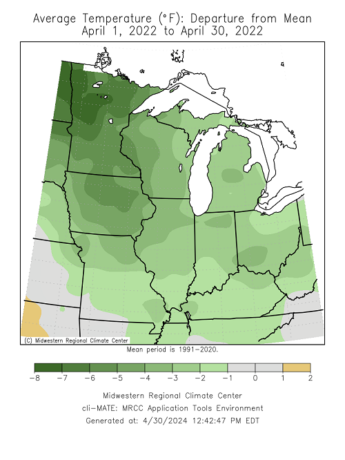
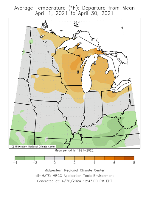
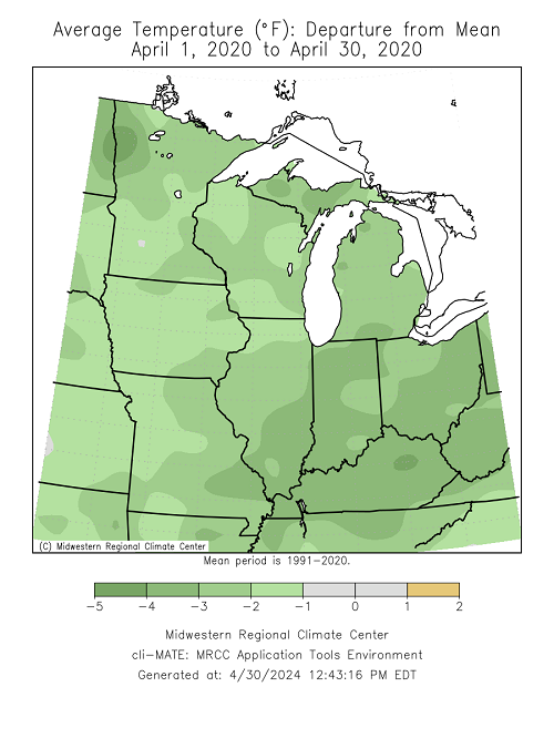
Prelim data in for April, and we have another warmer month in the books this year. April's sure have struggled to be on the warmer side in recent years for the sub as whole. 5 & 10 yr trend charts shown respectively.
-
Very nice day with temps peaking in the low-mid 60's. Dandelions started opening up today. Windy off the Lake tomorrow with shwrs, stms on tap later in the day/overnight.
-
1
-
-
3 hours ago, weatherbo said:
Made it to 67 earlier today before thicker clouds arrived. Spotty rain is moving through with barely a trace so far, temp down to 47... house is chilly, debating a fire.
Cool, and damp wx? No debate here...light it up.
-
1
-
-
0.19" of rain moved through today. Sun has broken though, and now temps up a little into the low-mid 50's from upper 40's early this afternoon. Nickels n dimes on the rains, but it keeps the needle slowly heading upward.
-
1
-
-
0.29" of rain yesterday, and very nice today with gusty W/SW winds. Temps in the upper 60's - low 70's. Started off with dense fog along the shore, but that lifted pretty quickly this morning. Looks like the first mowing of the grass will be really soon. Almost to that point right now.
-
1
-
-
Another round of rain on my doorstep. Sun came out yesterday afternoon, and temps jumped from low 40's at 1 pm to around 60 by 3 pm.
-
1
-
-
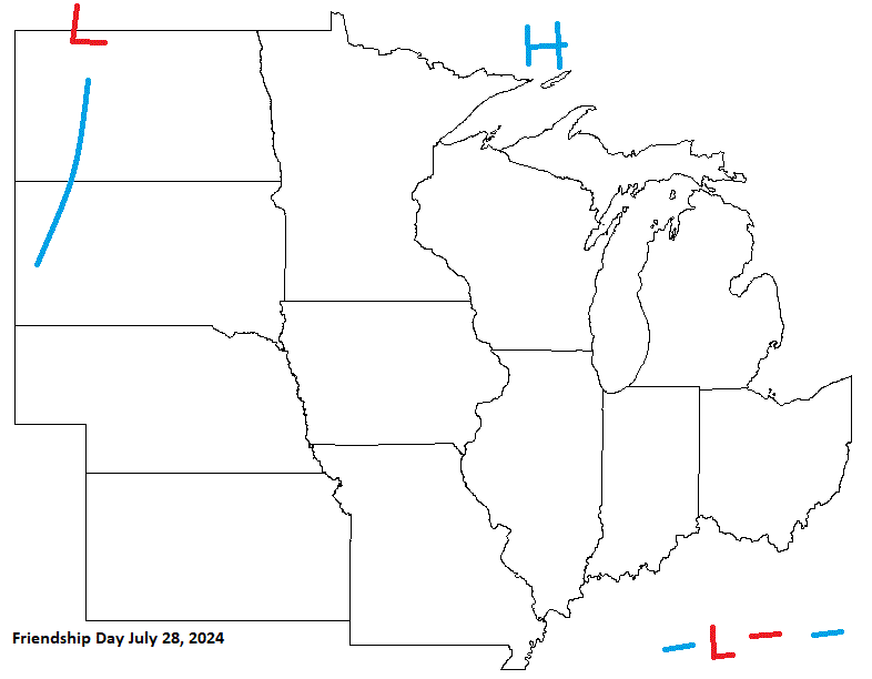
Friendship Day looking pretty decent with most of the sub under the influence of HP. Looks like a boundary may affect the southern most part of the sub. W areas could get a little on the hot side with a boundary in the Plains.
-
July 4th is on a Thursday this year. Looks pretty nice to me. Could get real warm in the W sub on the backside of HP moving through, ahead of next system lurking to the W.

-
0.21" of rain last night into the early morning hours. At least caught a little Sun yesterday, because there will not be much this week.
-
This could be an interesting run in the coming months with Ruang in Indonesia blowing it's top. If we are going into a neutral/La Nina phase, this could possibly have an effect combined with that. Kind of like Hunga Tonga combined with a rapid swing into El Nino. It takes a few months for things to swirl around the globe, and spread out. Good YT vid, along with ISS vid showing ash from space.
-
1
-
-
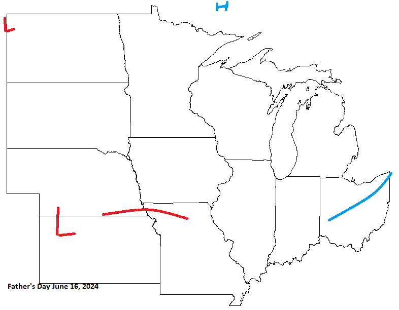
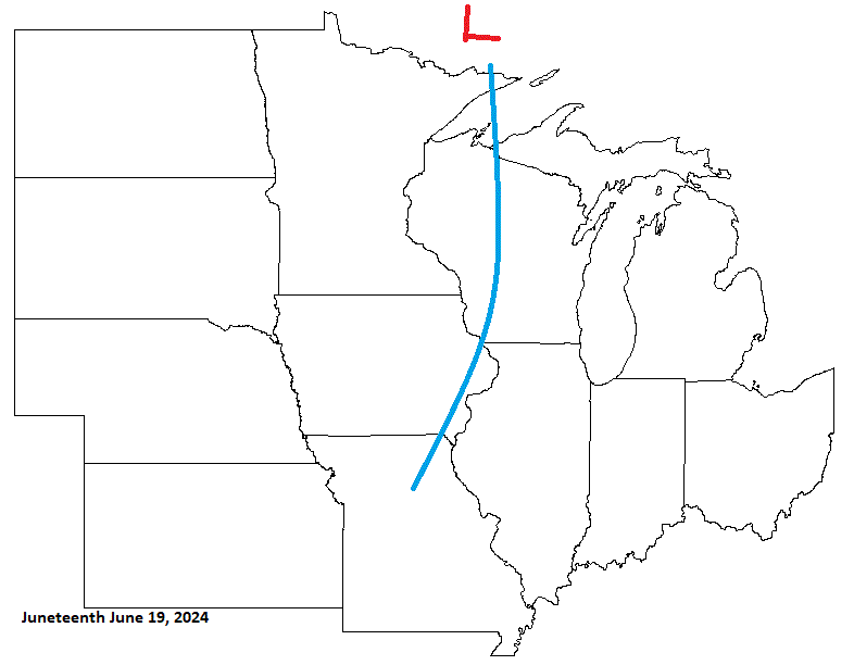
Next up is Father's Day, and I'll also include Juneteenth, as it is only 3 days after.
Expecting a system moving through prior to Father's Day, with CA HP clearing things out briefly, before another system encroaches upon the sub. This will be affecting the sub around, and on Juneteenth. Mid June looks wet, and stormy as we approach the Summer Solstice.
-
1
-
-
On 3/7/2024 at 2:24 PM, Brian D said:
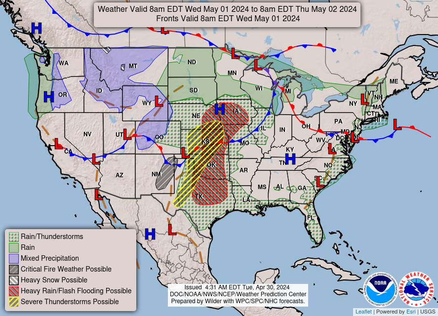
On May Day (May1st) looking at a front moving through with chilly air behind.
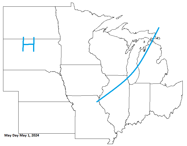
Was a little too quick in bringing in HP, as more energy rides NE before HP arrives with drier, cooler wx for a couple days. Could get cold enough for frost in some areas. Then another system(s) moves in next week.
-
1.36" for a 2 storm total. 3.05" to end the month (2.65" avg) here in TH.
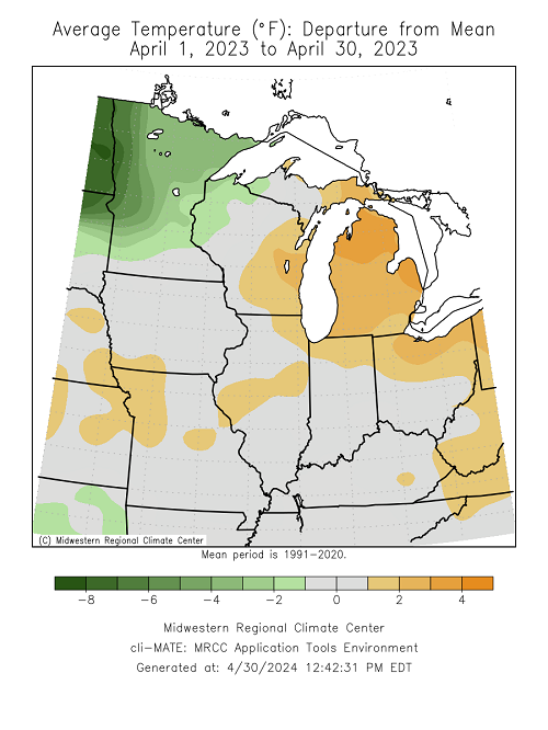
Our sub actually had a rather warm April this year overall for a change.

-
 1
1
-
-
About 3/4 - 1" of rain around here so far with scattered showers in the area. Next round slated for tomorrow into Monday. My deceased son's b-day tomorrow. Getting together with family. Going to be an ugly day, as winds will be running 30-40 off the Lake with the rain starting around midday.
-
 1
1
-

Holiday Forecasts 2024
in Lakes/Ohio Valley
Posted
Front a little more aggressive coming down from CA. System will run through S sub along the boundary. So I was more aggressive with the system moving a little more N. Not too bad of a call here. There will be some showers/stms moving through our sub.