
WhirlingWx
-
Posts
404 -
Joined
-
Last visited
Content Type
Profiles
Blogs
Forums
American Weather
Media Demo
Store
Gallery
Posts posted by WhirlingWx
-
-
On 4/28/2023 at 6:48 PM, Chargers09 said:
Got ping pong ball sized hail
Did you have any damage?
-
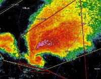
pretty nice radar structure on the tornado warned storm west of Waco
-
25 minutes ago, cheese007 said:
FWD still seems bullish this afternoon/evening
I see nothing wrong with them continuing to be bullish, after all, our talk of a perhaps tempered threat is mostly for I-20 and north, but south of that is still within the FWD coverage area
-
I'm not sure that the warm front has moved any more than 10 miles north in the past 3 hours
Again, this is more of an observation for MBY. Still a threat that can materialize to the south imo
-
The storms near and south of Wichita Falls look like they're building south, they might impact northern DFW in a few hours at that rate. Might temper the threat for areas north of Dallas - Fort Worth later on, but still unsure.
-
A little storm along the cold front to my southwest might bring some hail my way if it keeps strengthening. My car is pretty exposed right now and I'm unable to do anything about it

-
Storm is tornado warned now moving into the south OKC metro
-
Think it's important to mention the deadly tornado in Bollinger County, MO, because I haven't seen any of that in here. 5 killed by that strong tornado (prelim high-end EF2) after 3 AM. Tragic and yet another example of how "it only takes one" despite the event technically not reaching its ceiling.
-
 1
1
-
-
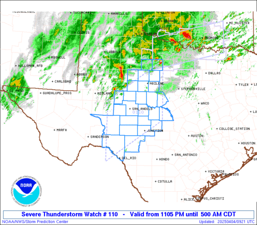
SVR for Jack, Wise, and Montague counties atm, already warned for golf ball sized hail
-
Tornadoes
Probability of 2 or more tornadoes Mod (60%)
Probability of 1 or more strong (EF2-EF5) tornadoes Mod (40%)
Wind
Probability of 10 or more severe wind events Mod (50%)
Probability of 1 or more wind events > 65 knots Low (10%)
Hail
Probability of 10 or more severe hail events High (90%)
Probability of 1 or more hailstones > 2 inches High (70%)
Combined Severe Hail/Wind
Probability of 6 or more combined severe hail/wind events High (>95%)
-
 1
1
-
-
Lots of little cells going up between Mineral Wells and Vernon, so far
-
4 hours ago, radarman said:
April 2nd is a notorious day for severe weather in Dallas.
1957 F3, right?
-
1
-
-
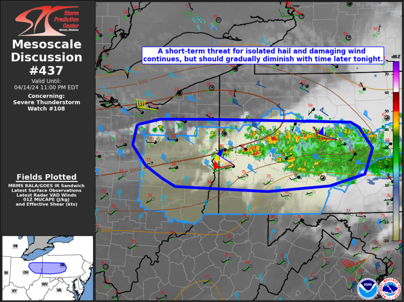
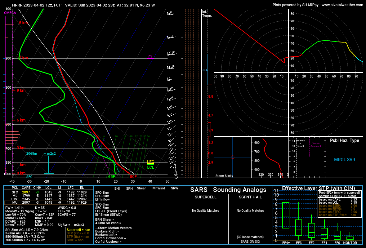
Graphic for the above MD discussion... can't help but comment on how I really like the style for these, haha
-
1
-
-
-
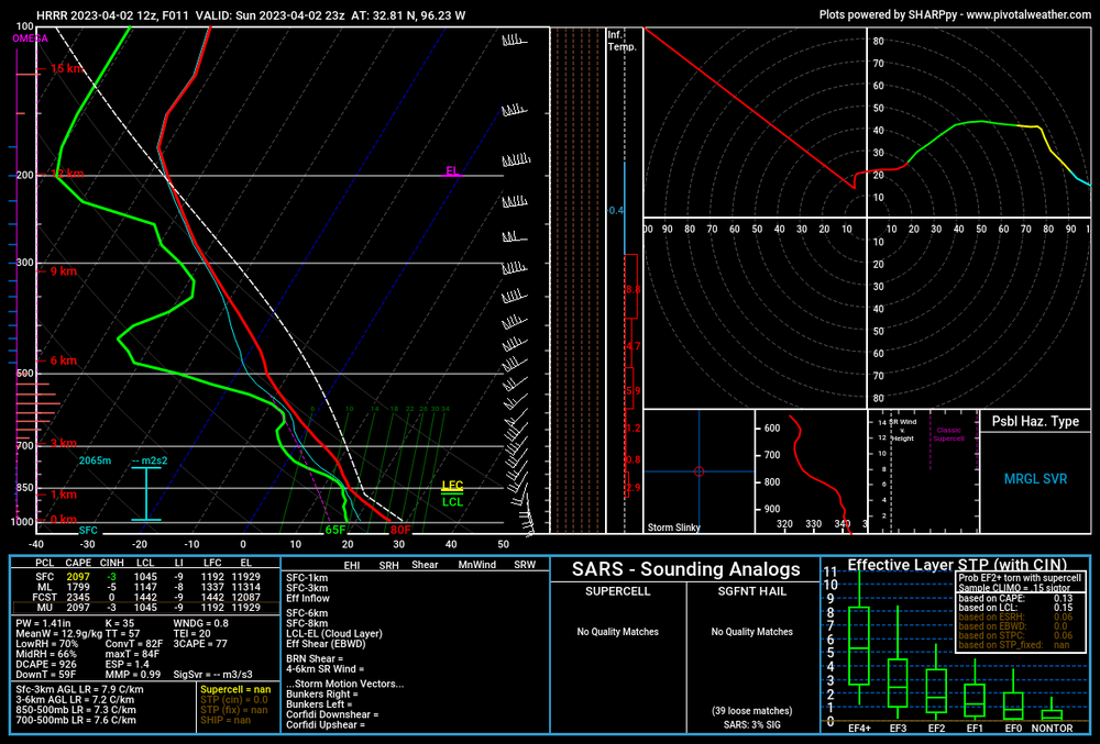
Trying to check hodographs in DFW valid around 6 PM but uh.. this happening for anyone else?
-
10% sig added
-
13 minutes ago, radarman said:
where in the metroplex?
near Murphy. I was in my car at a park that has great views to the west, and I was seeing power flashes all along the line of storms, including from the general direction of where the tornado warning was issued.
-
1
-
-
I've seen dozens of power flashes in the past 15 or so minutes from my location.
-
1
-
-
Just now, Powerball said:
It would be surprising to me if April 2011 was the last moderate risk.
iirc some day in May 2015 had a moderate risk (might have even been tornado-driven as well).
Anyways, I think we're approaching the points where obs > models, though I can't help but notice that recent HRRR runs really blow up convection (in the form of supercells) west/northwest of DFW, like in the area that has the severe thunderstorm watch atm. Wind fields don't look very favorable for TORs so maybe the hail threat actually maximizes there? Either way the QLCS can pose problems for us later.
-
52 minutes ago, Powerball said:
Was October 2019 a moderate risk?
I think DFW was on the southern edge of an enhanced risk for that
-
2
-
-
Some pretty serious wording on the most recent SPC outlook
Day 1 Convective Outlook
   NWS Storm Prediction Center Norman OK
   1029 AM CST Sun Feb 26 2023

   Valid 261630Z - 271200Z

   ...THERE IS A MODERATE RISK OF SEVERE THUNDERSTORMS CENTERED ON
   WESTERN...CENTRAL...AND NORTHERN OKLAHOMA...

   ...SUMMARY...
   A derecho is forecast with widespread damaging winds and embedded
   swaths of significant severe gusts from 80-110 mph, centered on
   parts of Oklahoma this evening into tonight. Embedded tornadoes are
   anticipated as well, with the greatest potential for strong
   (EF2-EF3) tornadoes across southwest Oklahoma this evening.

   ...Southern Great Plains to the Mid-MS Valley...
   Just-in-time moisture return from the western Gulf is still
   anticipated ahead of a powerful shortwave trough ejecting from the
   Southwest to the Lower MO Valley. 60+ F surface dew points remain
   confined from the Piney Woods of east TX to the Concho Valley and
   Edwards Plateau of west TX as of 16Z. Guidance continues to differ
   with the northern extent of this richer moisture by evening in KS/OK
   beneath a stout elevated mixed layer. Widespread cloudiness is also
   evident over much of the southern Great Plains, although clearing
   should occur from west to east across the High Plains. The net
   result should be a narrow plume of surface-based instability along
   the dryline from southwest KS to west TX between 21-00Z.

   Scattered convection will break out after 21Z along the dryline and
   become supercellular towards 00Z given very favorably enlarged low
   to mid-level hodographs. Further moistening into the evening should
   result in the most favorable potential for supercell tornadoes in
   southwest OK between 00-03Z, in addition to very large hail.
   Convection will likely grow quickly upscale into a solid QLCS,
   accelerating east-northeast with embedded supercells and
   mesovortices. Extreme low-level shear profiles in conjunction with
   strengthening of 700-mb winds to around 90 kts behind the line
   should result in widespread severe wind gusts. Embedded swaths of
   80-110 mph winds both straightline and rotating are likely, with
   stronger speeds into the EF2 range possible, until the QLCS outpaces
   the richer moisture in the OK/KS/MO border area overnight. Scattered
   damaging winds from strong to severe gusts may linger through the
   early morning across MO towards the Mid-MS Valley, despite little to
   no buoyancy, given the intense low-level wind fields.

   ..Grams/Wendt.. 02/26/2023
-
1
-
-
Powder here near Murphy
-
 1
1
-
-
I can definitely see the elevated threat for NE Texas (for both damaging winds and tornadoes).
As for DFW, I'm still really not sure what to make of it... Seems very dependent on where the storms begin to form. A difference of 50 miles east or west could make or break the event for the metroplex.
-
1
-
-
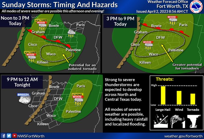
FWD is using some interested graphics that I've never seen before (apologies that I don't know how to resize the images)
-
2
-
Texas/Oklahoma Discussion & Obs Thread 2022
in Central/Western States
Posted
Most intense weather I've driven through so far during my couple years of driving