

Leesville Wx Hawk
-
Posts
232 -
Joined
-
Last visited
Content Type
Profiles
Blogs
Forums
American Weather
Media Demo
Store
Gallery
Posts posted by Leesville Wx Hawk
-
-
33 minutes ago, PackGrad05 said:
EPS currently showing a 38% chance of trace of snow for Wake over next 14 days. 18% chance of 1 inch.
Does it show the Wake County gradient?
-
 1
1
-
 1
1
-
-
Well the cats out of the bag now. I hinted before 0z came out.
-
1
-
 1
1
-
-
Blue horseshoe does like that time period for frozen precipitation in the Raleigh Durham area. I can’t disclose my external source beyond the EPS because synoptic setup not quite ideal yet but source is confident for some reason.
-
Aa Jethro Bodine once said: “ Where’s all the moon maidens?”
-
12z OP not raising spirits or glasses. Hopefully Ensembles keep hope alive and well.
-
Pretty obvious to most folks MET1985. Good job making your point clear.
-
2
-
 1
1
-
-
It’s looking like there will be something to watch moving forward.
. -
GEFS NAO forecast showing it headed downward towards the end of 15 day period and visually looks to be headed that direction via 12Z GEFS towards end of run. Need ridge to pop out west and then you have a favorable synoptic set up say Feb 10 onward for a bit.
-
It looks to form too far offshore to me but it’s early. 18 z gfs not bad but not there either. Need it to dig slightly more and west.
-
2
-
-
Saw that and noticed the same thing. Who knows at this point? I personally hate dry cold like this so the warm up will be welcomed by me.
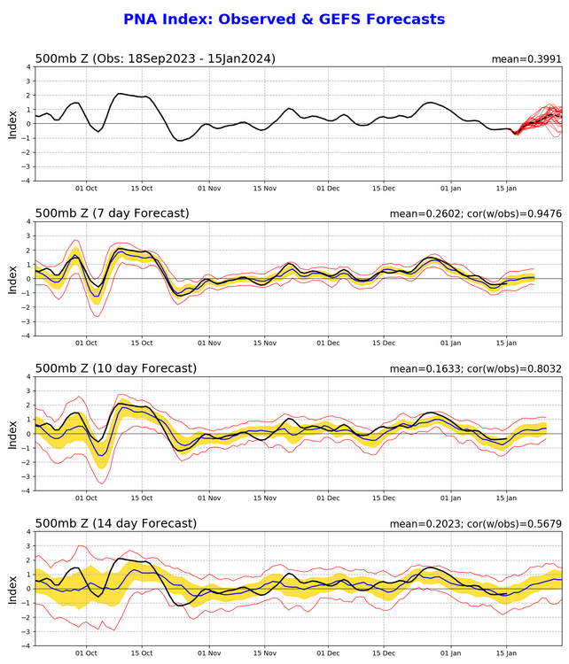
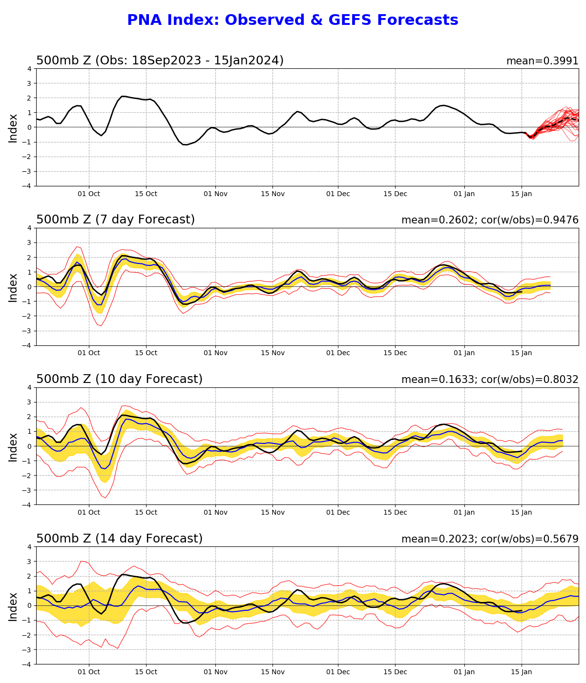
Perhaps things turn around after that and if we get a beneficial SSW.event then we could turn the NAO -. Griteater may have to adjust his snow possibility meter for early February unless ensembles show signs of a true + PNA like we were hoping for.
-
Here’s where it looks like we are headed and this is important for our region. We finally should go positive PNA in about 2 weeks (typical in El Niño). We won’t have a -NAO but at least we have a better shot than this current gig (generally no bueno) . A SSW could help eventually turn NAO negative but that’s speculation at this time.
-
1
-
-
21 minutes ago, WinstonSalemArlington said:Could someone explain to me what it takes for Arctic fronts to enter the States in the East instead of the West. It’s clear that’s polar invasion that includes Portland is going to be underwhelming here.
Need ridging in the west via Aleutian low (+PNA) so that cold air from Canada can move SE into our region. This should happen in about 2 weeks hopefully.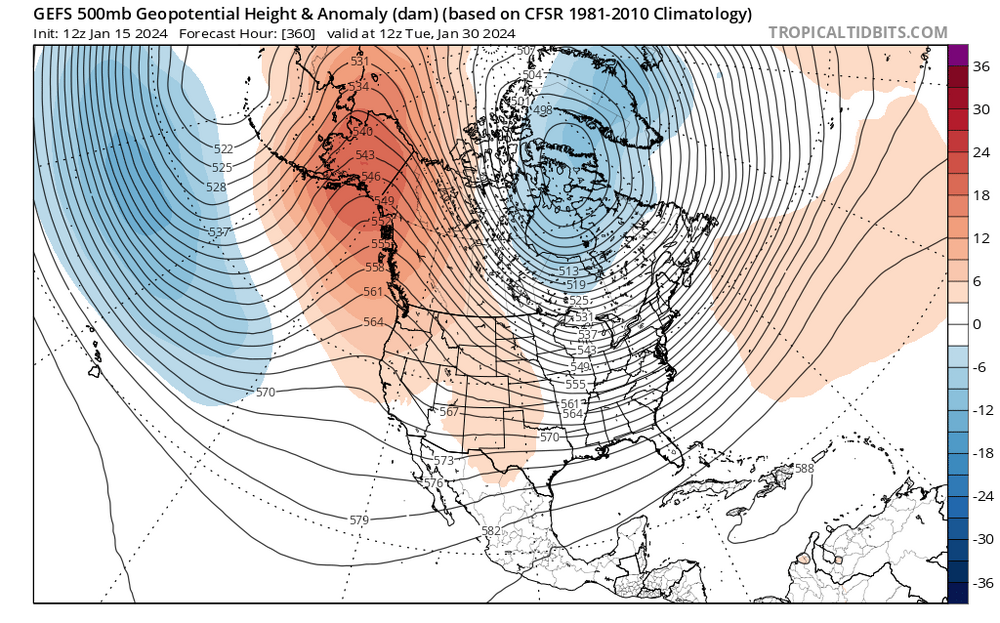
12 Z GEFS ensemble shows a ridge in the west that pushes the SE ridge. While not perfect, this is a better synoptic pattern for our region and something to follow moving forward.-
4
-
1
-
-
12 Z GFS a little closer to coast with Miller B
and Canadian a little further south. Temps marginal but higher rates may overcome before dynamics wane. It’s still a long shot but not impossible.
it’s sad but at least we can track something. It’s our last chance for 2 weeks. We can only hope that positive PNA can save the day. The SE ridge may not be as much of a factor and we could possibly cash in.
-
1
-
-
I’ve been looking for this one to be our flizzard LOL. This looks to be a better shot for some of us on this forum. It did get the Wake County gradient so there is that.
-
2
-
-
Need Tony the great Romo instead!
-
Good luck Winston! We’ve got nothing working just north of RDU but would love to see a snow flurry! Perhaps Friday AM for our brief snow/rain mix?
-
0z NAM showing precipitation over northern NC Tuesday night for possibly some snow that could give a dusting by Wednesday AM. This was advertised earlier on an earlier GFS run today. Something to watch.
-
1
-
-
Can we swing that 50 miles south so that RDU gets over 1”?
-
1
-
1
-
-
12 Z op GFS is a DC crusher for Friday with most of us with cold rain. Who knows at this point but at least there’s a storm for someone to potentially monitor.
-
12 Z GFS has northern NC again for Tuesday night with some snow.
-
1
-
-
48 minutes ago, Shack said:
NC folks: GFS still giving hope.....(yeah, I know)

I would take that and walk away for myself but not a good hit for a lot of this forum.
-
Perhaps next weekend? Our last shot unless things turn around for Tuesday.
-
You are others not so much.
. -
0 Z Jan 20th has some snow in NC. Something to watch as it will already be cold enough when/ if precipitation arrives.
-
1
-

Mid to Long Range Discussion ~ 2024
in Southeastern States
Posted
30 inches is a bit too much snow to me. The thing is that a storm is entirely possible now given the blocking is currently forecasted on the ensembles.
.