stormdragonwx
-
Posts
512 -
Joined
-
Last visited
Content Type
Profiles
Blogs
Forums
American Weather
Media Demo
Store
Gallery
Everything posted by stormdragonwx
-

MO/KS/AR/OK 2020-2021 "Winter" Discussion
stormdragonwx replied to JoMo's topic in Central/Western States
Exactly this. Its been bad all winter. Seen it initialize this past week alone being way too warm so you can throw it out from the get go. -
MO/KS/AR/OK 2020-2021 "Winter" Discussion
stormdragonwx replied to JoMo's topic in Central/Western States
Like I said I'm betting TSA's near 3k day streak of no Blizzard Warnings Issued is about to come to an end. -
MO/KS/AR/OK 2020-2021 "Winter" Discussion
stormdragonwx replied to JoMo's topic in Central/Western States
So much this. I too want to get excited but I've seen it happen so many times where it looks great then 24-36 hours out the system either comes in weaker/too dry and/or takes a different track. -
MO/KS/AR/OK 2020-2021 "Winter" Discussion
stormdragonwx replied to JoMo's topic in Central/Western States
Just for fun I looked this up. If things pan out as they are currently trending with the precip and strong winds, many of these WFO areas with 1500+ days since a Blizzard Warning may see those numbers getting reset next week.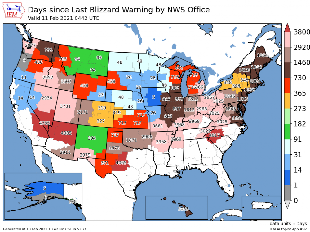
-
MO/KS/AR/OK 2020-2021 "Winter" Discussion
stormdragonwx replied to JoMo's topic in Central/Western States
Fortunately a guy I follow the most out of Oklahoma is being realistic. Mike Collier at KJRH Channel 2 in Tulsa. https://www.facebook.com/MikeCollierWx/posts/263396651804279 Travis Meyer (KOTV Channel 6 Tulsa) is also pretty cautious on what he posts too. -
MO/KS/AR/OK 2020-2021 "Winter" Discussion
stormdragonwx replied to JoMo's topic in Central/Western States
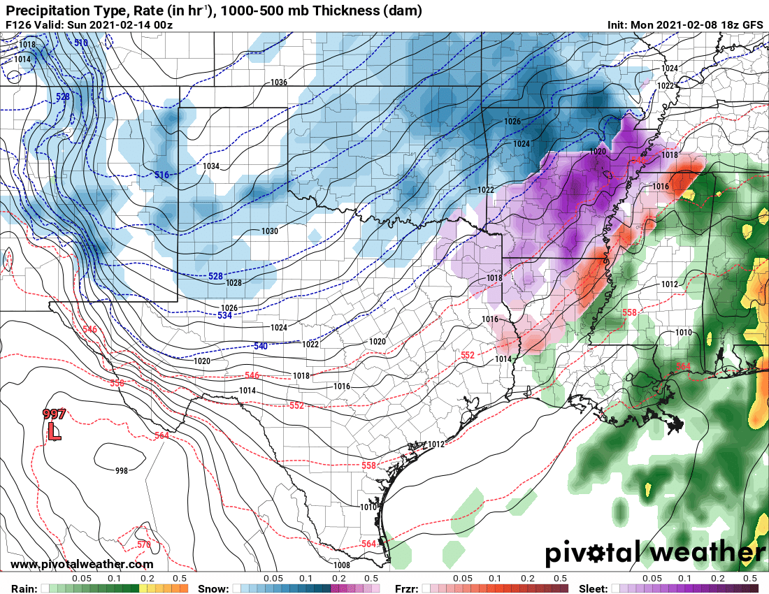
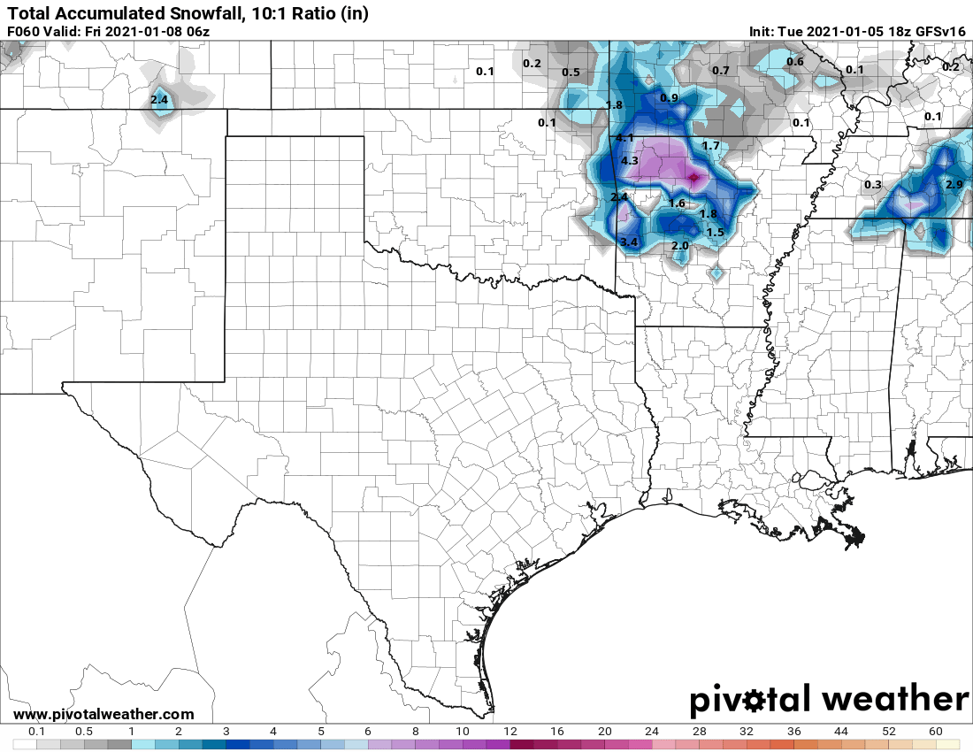
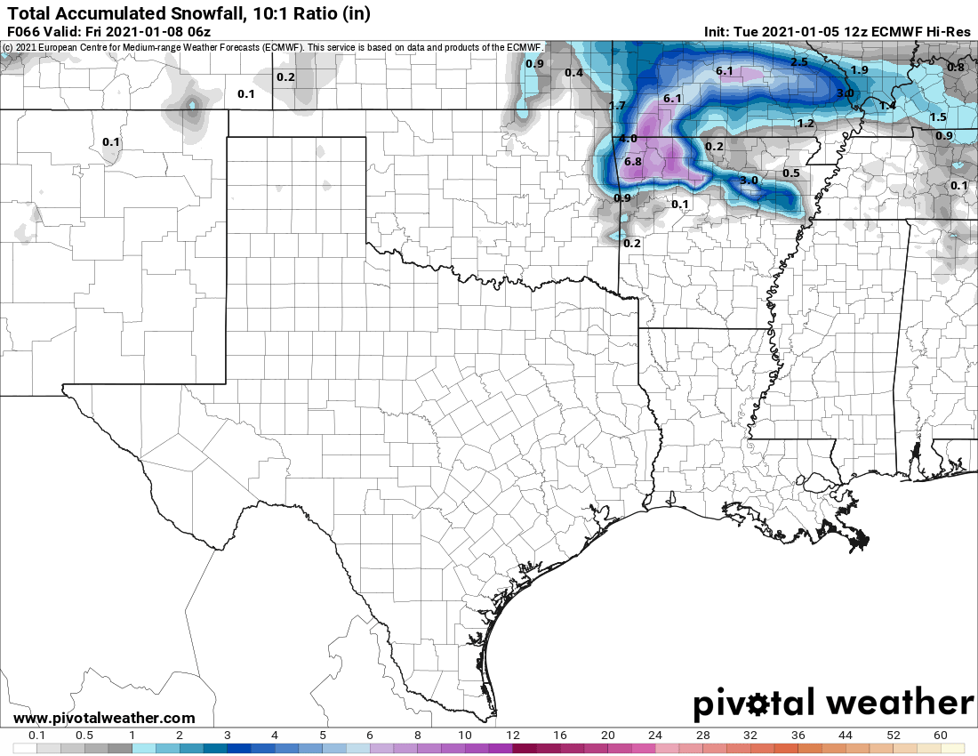
Spot on. And yes a couple ensemble posts were made a few pages back from the GFS and Euro. Nearly all are showing the area getting slammed. The attached image below is from the latest 18z run on the GFS.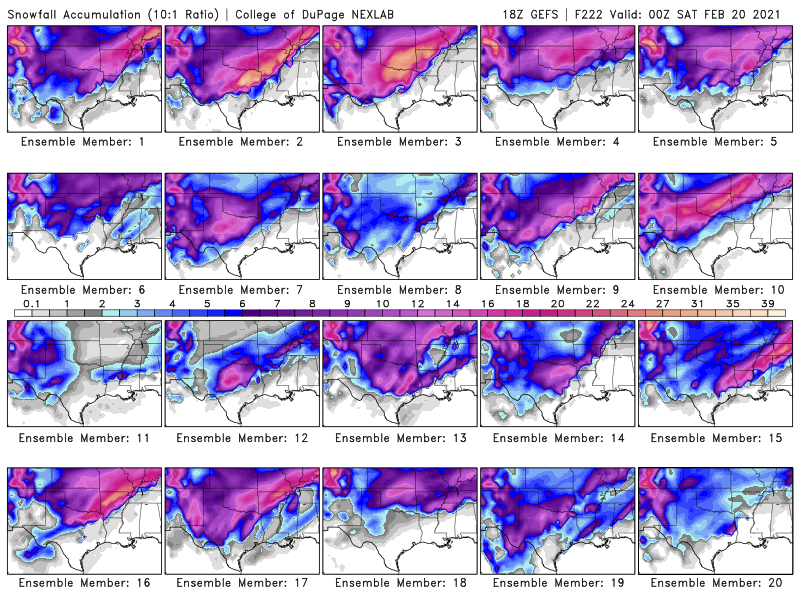
-
MO/KS/AR/OK 2020-2021 "Winter" Discussion
stormdragonwx replied to JoMo's topic in Central/Western States
I will agree there is huge potential for the "hypetrain" to get derailed on this. A couple more days will hopefully tell us for sure which way this goes. -
MO/KS/AR/OK 2020-2021 "Winter" Discussion
stormdragonwx replied to JoMo's topic in Central/Western States
Problem with the NAM myself and a few others have seen and noted is that its been initializing a bit too warm for this area around here for the past few days. Take that as you will. Might have to consult the RAP, HRRR, and short range Canadian (RDPS) for more reliability. I do also have concerns for dry air intrusion especially with how cold we will be getting by that time. -
MO/KS/AR/OK 2020-2021 "Winter" Discussion
stormdragonwx replied to JoMo's topic in Central/Western States
Some fun with the GFS ensembles here, if it doesn't snow next week somethings wrong. -
MO/KS/AR/OK 2020-2021 "Winter" Discussion
stormdragonwx replied to JoMo's topic in Central/Western States
Here it is... (GFSv16)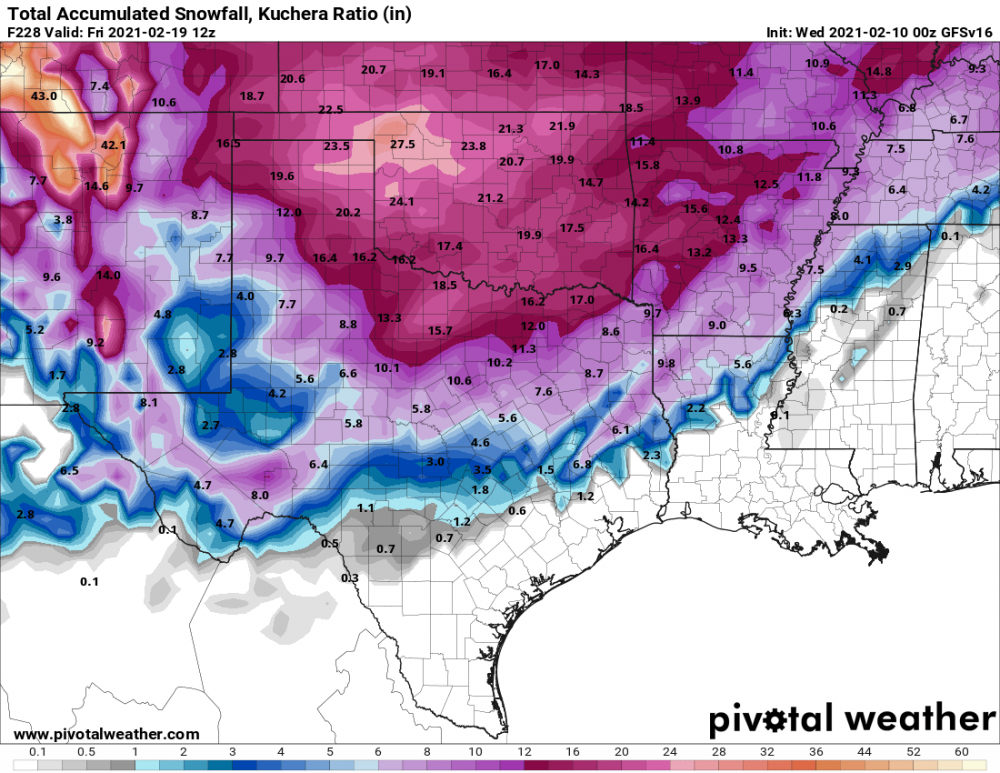
-
MO/KS/AR/OK 2020-2021 "Winter" Discussion
stormdragonwx replied to JoMo's topic in Central/Western States
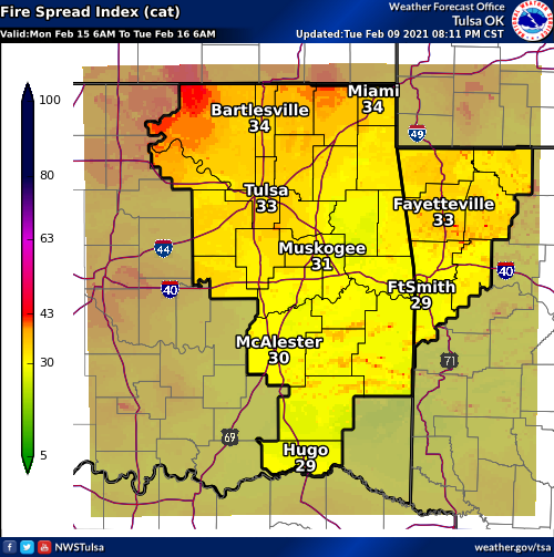
The TSA DSP graphic map has both fire spread danger and snow on the ground at the same time. Can someone explain that? lol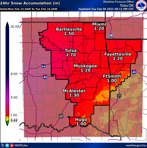
-
MO/KS/AR/OK 2020-2021 "Winter" Discussion
stormdragonwx replied to JoMo's topic in Central/Western States
So apparently there is a microscale incident ongoing in Springdale, Arkansas with snow being reported there but nowhere else in the general area of NW Arkansas. https://twitter.com/4029Darby/status/1359292728794882049?s=20 -
MO/KS/AR/OK 2020-2021 "Winter" Discussion
stormdragonwx replied to JoMo's topic in Central/Western States
Yeah just took a peek at it myself. We shall see what the NAM does when it comes into range. Edit: StormChazer beat me to it lol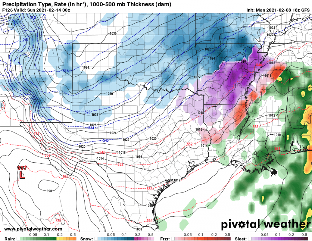
-
MO/KS/AR/OK 2020-2021 "Winter" Discussion
stormdragonwx replied to JoMo's topic in Central/Western States
Yeah we are gonna have to see an extra push of that Arctic air or some clearing otherwise we are just gonna remain stuck with cold rain/mist thru the duration of this. I'm not sure unless we get a big storm system thru here if evaporative cooling will be enough. -
MO/KS/AR/OK 2020-2021 "Winter" Discussion
stormdragonwx replied to JoMo's topic in Central/Western States
Hate to be that guy but I got a feeling this whole thing is gonna be another bust if you are expecting a major storm system, e.g we will see marginally cold air with too much dry air aloft and a less than ideal jet stream pattern for Lows to track and strengthen as they move over us. The models being all over the place for this have not helped any. -
MO/KS/AR/OK 2020-2021 "Winter" Discussion
stormdragonwx replied to JoMo's topic in Central/Western States
Also in 2011 Nowata, OK got down to -31 which is an all time record low for that state. -
MO/KS/AR/OK 2020-2021 "Winter" Discussion
stormdragonwx replied to JoMo's topic in Central/Western States
I'd love to see a winter outdo 2011 in my lifetime but I have a feeling that will be hard to come by. We will just have to wait and see. -
Agreed 2020 was mostly a bust. Too soon to make a 2021 thread? With the strong La Nina pattern taking shape we may be in for a very interesting spring.
-
MO/KS/AR/OK 2020-2021 "Winter" Discussion
stormdragonwx replied to JoMo's topic in Central/Western States
It's still a week out so obviously it's gonna change a lot. The timing would be fitting as this would be almost 10 years to the day of the 2011 blizzard that brought upwards of 2 feet of snow in NW AR.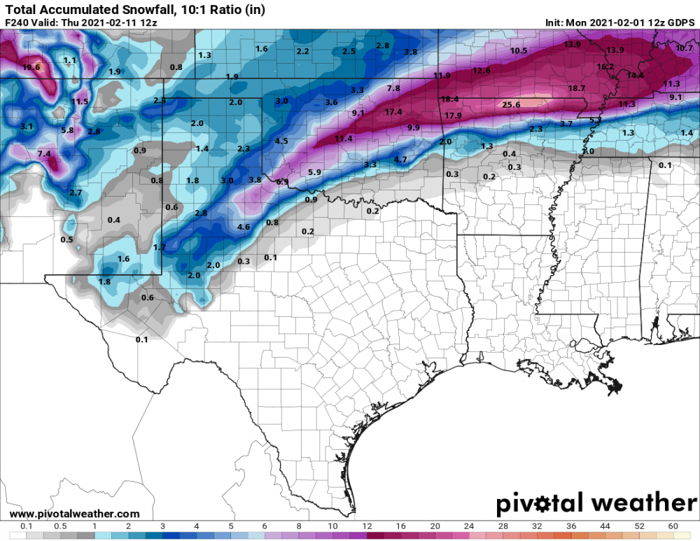

-
MO/KS/AR/OK 2020-2021 "Winter" Discussion
stormdragonwx replied to JoMo's topic in Central/Western States
And I figured as much. 00z came back down to reality.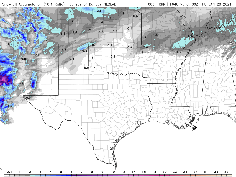
-
MO/KS/AR/OK 2020-2021 "Winter" Discussion
stormdragonwx replied to JoMo's topic in Central/Western States
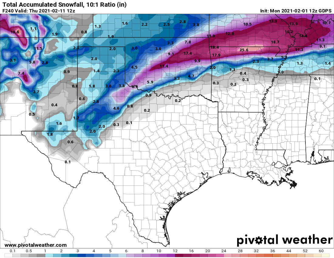
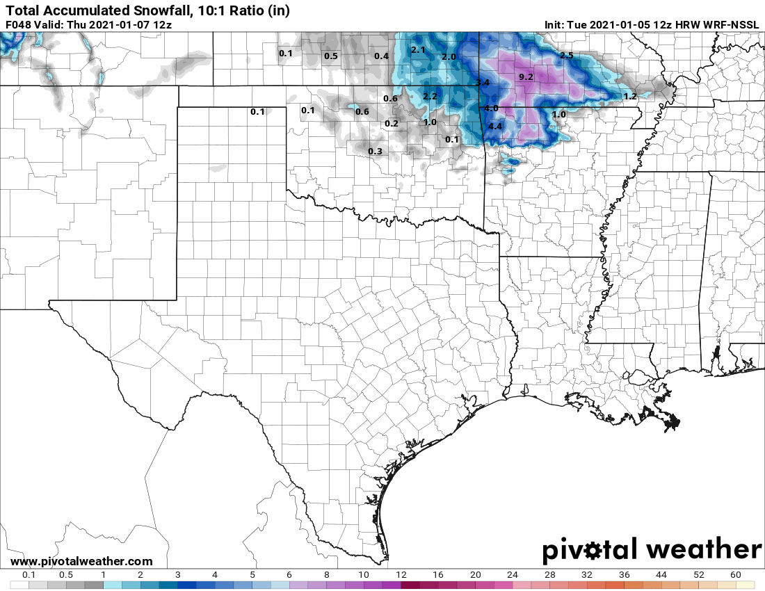
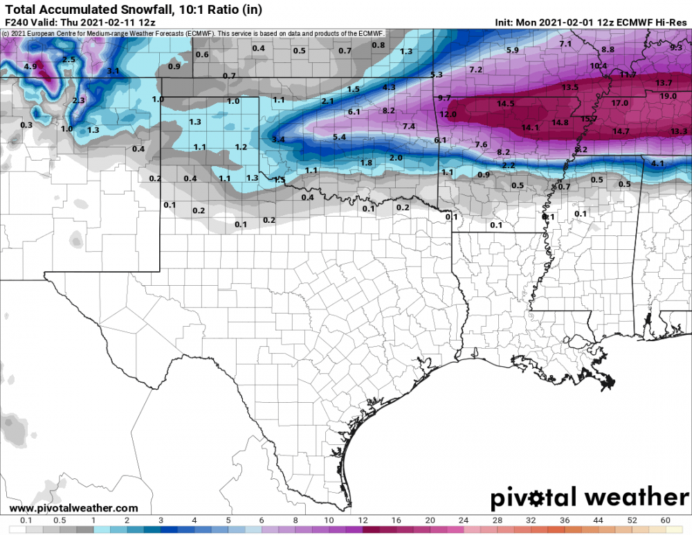
Was noticing today the HRRR has come into range for Wednesday's winter weather potential. While most other models (save for the Canadian) have been showing this as a mostly non-event, the HRRR just went bonkers in comparison showing 3-5" totals. I was watching the Canadian for the past few days and it was showing some potential for accumulating snow too. (1-3"). We will just have to watch for trends. This might surprise us. I know the Canadian has been doing pretty good this season.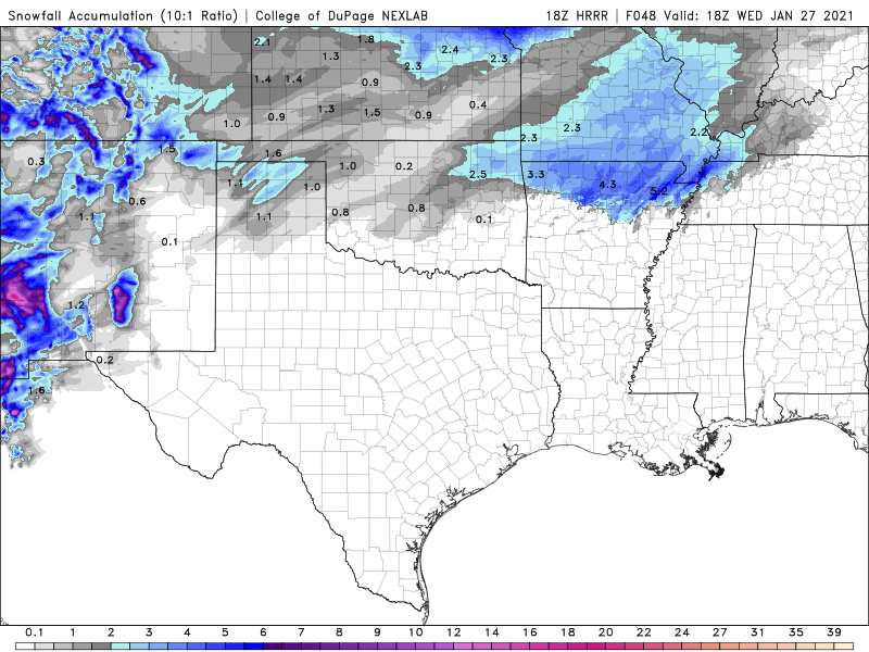
-
MO/KS/AR/OK 2020-2021 "Winter" Discussion
stormdragonwx replied to JoMo's topic in Central/Western States
And here I was actually thinking this winter had potential. The trend continues, sadly. -
MO/KS/AR/OK 2020-2021 "Winter" Discussion
stormdragonwx replied to JoMo's topic in Central/Western States
Yeah these winters anymore are like a broken record. They seem to have an interesting start then peter out after January. -
MO/KS/AR/OK 2020-2021 "Winter" Discussion
stormdragonwx replied to JoMo's topic in Central/Western States
Lol that was a non-event for my neighborhood again, as usual. Next! -
MO/KS/AR/OK 2020-2021 "Winter" Discussion
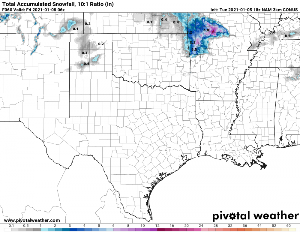
stormdragonwx replied to JoMo's topic in Central/Western States
Liking these trends for my area being less than 48 hours out. 18z GFS (v16), 12z Euro, 12z WRF, and finally the 18z NAM 3km Waiting for the 00z models to finish up their runs. I bet the WSW gets extended north and west a bit.