

Modfan2
-
Posts
2,374 -
Joined
-
Last visited
Content Type
Profiles
Blogs
Forums
American Weather
Media Demo
Store
Gallery
Posts posted by Modfan2
-
-
2 minutes ago, Damage In Tolland said:
Pike south is gone
Short memory; models last week were all doom and gloom east and how did that work out??? I think pike south sees a decent amount of frozen be it a sleet fest or freezing rain
-
9 minutes ago, Damage In Tolland said:
No it won’t be mostly rain. It’ll start as a cold rain Thursday and switch to ice late that night and then to snow Friday . That’s model concensus
Nope, you to the pike still in the game for ice/sleet fest.
-
47 minutes ago, ineedsnow said:
CMC might be a tick colder at 18z hard to tell though either way it would be a heck of a ice storm here
Like the previous storm this will waver north/south and end up being a nowcast at the end of the week.
-
 1
1
-
-
10 minutes ago, JC-CT said:
pretty nasty for NW CT verbatim
And NE CT
-
While the cooler trend continues I think from Kevin north to maybe the pike sees more ice/sleet than snow
-
I think the colder trend is real, just don’t think it’s to snow; think pike south could be a IP/ZR fest. Trend is your friend
-
1 minute ago, CoastalWx said:
I wouldn't mind some meat in the pack to help seal it up from Tippy Feb sun. It's still weak, but those days near 32 and full sun do melt it.
I agree, you closer to making the existing pack a block of ice than adding another foot to it
-
While two storms are never alike, trends last week were east and to a slight extent they were right; why discount the cooler ticks we have see since yesterday?
-
 1
1
-
-
So, given the models shift to the east towards the end of the week, which suite performed best? Cut off
-
I mean the band from 395 in Mass down into CT just won’t quit
-
1
-
-
Has Forky been in here today to comment on the further east slides the models are showing?
-
Amazed that the band has stayed persistent around 395 belt in CT/Ma
-
1
-
-
@CT Rainstation should be sending up the Snow Monster in Killingly or common on Thompson Hill
-
Band coming into Boston forcing precip shield further west past Worcester now.
-
1
-
-
Going to be so 2FT amounts Killingly/Putnam area
-
2
-
-
From Plainfield CT through Putnam and Killingly into NW RI getting smoked
-
1
-
-
Do those two bands in E CT merge?
-
Band pushing back towards 84 now in CT
-
Another band setting up just west of Sturbridge; should help DIT
-
Wind chills down here in S FL near 20, lows near 32; eastern CT/RI looking good
-
8 minutes ago, Damage In Tolland said:
It will depend where that sets up shop. It’s orienting and moving
It doesn’t appear to be moving to far west
-
8 minutes ago, Ginx snewx said:
2.5 new first gusts coming in now.
Steady as she goes brother, enjoy!
-
1
-
-
12 minutes ago, Ginx snewx said:
Not liking this Euro slide east. Want the Epicosity back like NAM RGEM Canucks JMA
Isn’t the Euro better long range and not so much within 48hrs?
-
 1
1
-
-
3 minutes ago, JC-CT said:
Euro is still stronger with the northern stream and has a higher pacific ridge. Overall I think this run will be decent?
I agree and I think that Jack zone will make it to E CT/W RI
-
1
-
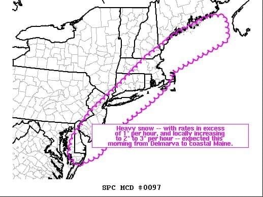
New England Overrunning Event 02/03-02/04/22
in New England
Posted
This is either a kiss of death of a full blown ice storm or all rain!! Lol