Duca892
-
Posts
703 -
Joined
-
Last visited
Content Type
Profiles
Blogs
Forums
American Weather
Media Demo
Store
Gallery
Everything posted by Duca892
-
Reading Stephen King’s “IT” and getting ready for 10:30est play by play for 0z GFS.
-
E PA/NJ/DE Winter 2025-26 Obs/Discussion
Duca892 replied to LVblizzard's topic in Philadelphia Region
18z GFS holds for a warning level snow for many y -
I’m literally waiting with bated breath. Please hold you stupid son of a bitch
-
ICON step back?
-
E PA/NJ/DE Winter 2025-26 Obs/Discussion
Duca892 replied to LVblizzard's topic in Philadelphia Region
What would it take for this to become real to most? This thing isn’t that long out. It’s in midrange. EURO/GFS is warning level snows for many in this target area. Seeing the EURO jump up like that was awesome. Other than the GFS holding at 18z. What would others like to see latch on next -
E PA/NJ/DE Winter 2025-26 Obs/Discussion
Duca892 replied to LVblizzard's topic in Philadelphia Region
So we have the GFS/EURO with warning level snow for Thursday into Friday for the Lehigh Valley. -
Most important run of the GFS since 6hrs ago
-
E PA/NJ/DE Winter 2025-26 Obs/Discussion
Duca892 replied to LVblizzard's topic in Philadelphia Region
12Z GFS is like a 200-225mi treck west for next week on a massive snowstorm -
E PA/NJ/DE Winter 2025-26 Obs/Discussion
Duca892 replied to LVblizzard's topic in Philadelphia Region
GFS is really really really trying for next week…. -
This is kind of what I was sensing from people after just last week everyone hyped up mid-January as a pretty epic pattern… I’m too stupid to understand what happened between last week and now
-
E PA/NJ/DE Winter 2025-26 Obs/Discussion
Duca892 replied to LVblizzard's topic in Philadelphia Region
So it seems like our awesome pattern change already is playing kick the can down the road…? It seems like almost every year this happens and it just gets pushed farther and farther out lol -
E PA/NJ/DE Winter 2025-26 Obs/Discussion
Duca892 replied to LVblizzard's topic in Philadelphia Region
Feel like you can close the blinds on model watching for the next few days at least -
Boxing Night Snow/Sleet/Ice Dec 26-27 Storm Thread/Obs.
Duca892 replied to Mikeymac5306's topic in Philadelphia Region
These trending to being just a meh nuisance is so disappointing -
Boxing Night Snow/Sleet/Ice Dec 26-27 Storm Thread/Obs.
Duca892 replied to Mikeymac5306's topic in Philadelphia Region
Actually I wouldn’t be surprised if they still upgraded to a warning depending on sleet/FR totals across the Valley -
Boxing Night Snow/Sleet/Ice Dec 26-27 Storm Thread/Obs.
Duca892 replied to Mikeymac5306's topic in Philadelphia Region
Can I ask why is NWS so fairly bullish on this one? What models are outputting 4in in Philly, 6in in Allentown etc -
Boxing Night Snow/Sleet/Ice Dec 26-27 Storm Thread/Obs.
Duca892 replied to Mikeymac5306's topic in Philadelphia Region
I would like to think this doesn’t turn into a complete nothing burger but models keep trending north…. -
Boxing Night Snow/Sleet/Ice Dec 26-27 Storm Thread/Obs.
Duca892 replied to Mikeymac5306's topic in Philadelphia Region
NWS pretty bullish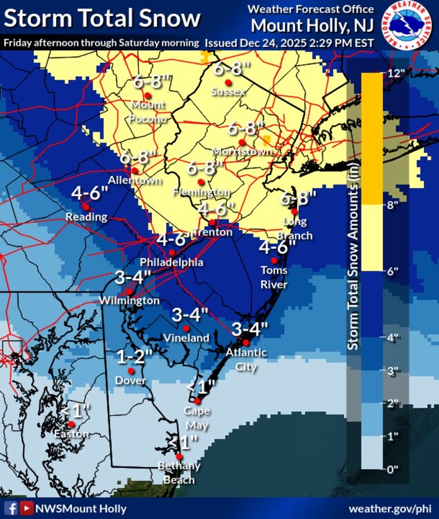
-
Boxing Night Snow/Sleet/Ice Dec 26-27 Storm Thread/Obs.
Duca892 replied to Mikeymac5306's topic in Philadelphia Region
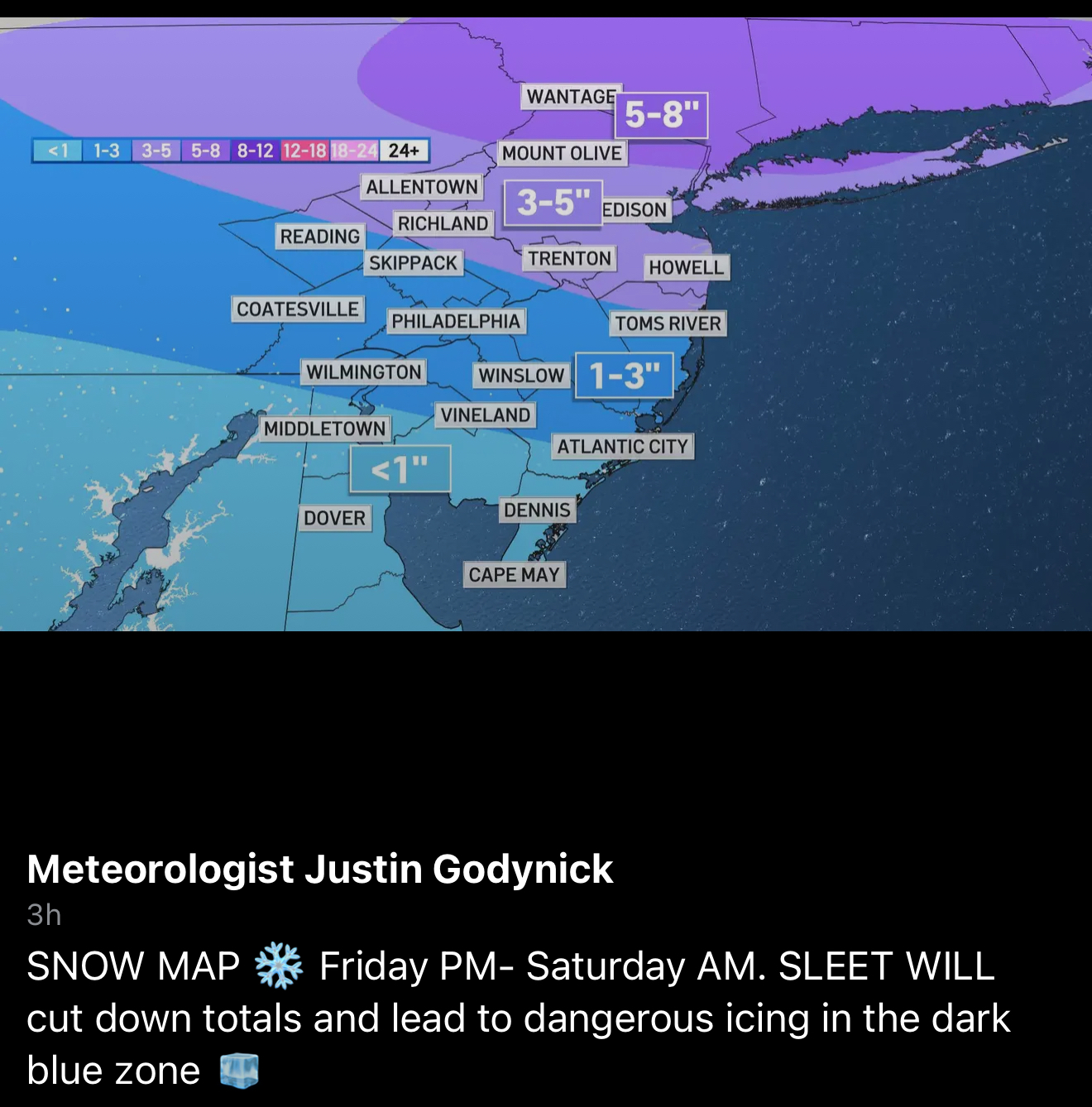
Probably the most accurate looking map I’ve seen
-
Boxing Night Snow/Sleet/Ice Dec 26-27 Storm Thread/Obs.
Duca892 replied to Mikeymac5306's topic in Philadelphia Region
So forgive me if I am looking at this so say Allentown has .2 of sleet. Does that mean 2in of the 7.3in of snow shown is the .2 of sleet and then 5.3in of snow? Like the 10:1 ratio? -
Boxing Night Snow/Sleet/Ice Dec 26-27 Storm Thread/Obs.
Duca892 replied to Mikeymac5306's topic in Philadelphia Region
Was hoping to wake up to a Christmas miracle but looks like we are headed towards a slop fest. Le sigh -
Boxing Night Snow/Sleet/Ice Dec 26-27 Storm Thread/Obs.
Duca892 replied to Mikeymac5306's topic in Philadelphia Region
Bleh looks more and more like a slop storm. Legit hate these. All I can think of is “Man what if this was all snow” -
E PA/NJ/DE Winter 2025-26 Obs/Discussion
Duca892 replied to LVblizzard's topic in Philadelphia Region
Gonna be one of those storms where you get 1-3in of snow and then a nice concrete layer of sleet on top. Yuck yuck yuck -
E PA/NJ/DE Winter 2025-26 Obs/Discussion
Duca892 replied to LVblizzard's topic in Philadelphia Region
I try my best to understand these. So if you are sandwiched between the red line from mid PA to the blue line in NE PA that is a cold rain? -
E PA/NJ/DE Winter 2025-26 Obs/Discussion
Duca892 replied to LVblizzard's topic in Philadelphia Region
As always this is me being Mr. I don’t know crap lol, but I feel like Fridays system has slowly ticked north ever since 6z GFS yesterday. Messy system all around. Doesn’t look like a classic snowstorm sadly -
E PA/NJ/DE Winter 2025-26 Obs/Discussion
Duca892 replied to LVblizzard's topic in Philadelphia Region
Man that storm on Friday just looks like a snow to icy mix mess