

Bob's Burgers
-
Posts
510 -
Joined
-
Last visited
Content Type
Profiles
Blogs
Forums
American Weather
Media Demo
Store
Gallery
Posts posted by Bob's Burgers
-
-
something is trying to pop east of wichita falls
-

Starting to think that cell might be a splitter
-
Outflow boundary setting up near norman and sagging southward a bit. could modify over the next hour or two and make things get real interesting around the Katie-Norman area.
Theoretical target: Pauls Valley
-
Excellent verification page from the Easter outbreak can be found here:
-
 1
1
-
-
Hopefully it busts. These people have been through enough lately
-
5
-
-
I'm getting increasingly concerned about the I-35 corridor from Fort Worth up to OKC. 21z RAP shows this area (OKC in particular) in an extremely favorable area of ascent (left exit jet region) during peak instability + dryline initiation. Just seems like an event that could "overperform" compared to current expectations with a rogue supercell or two going gangbusters. Low level lapse rates are formidable on HRRR and RAP forecast soundings as well. IDK

-
-
23 minutes ago, jpeters3 said:
Yeah, the 12z run seems to indicate enough recovery for supercells behind the MCS. Though CAMs seem to always under-estimate the southward component of MCS motion.
That does seem to be a theme. Also another theme is the RAP overestimating the northward push of the warm front/warm sector.
-
1 hour ago, jpeters3 said:
One thing to watch is that this run shows an early day MCS taking a substantial chunk out of the warm sector, which could end up being a bust mode.
The thing that is interesting to me is the timing. If it goes though early (12z or so) and the atmosphere can recover somewhat, couldn't we look at local hotspots with modifying outflow boundaries?
-
Looks like a real hoot

-
Figured it's time to start another thread (this is exhausting to see round after round of severe wx in the southeast) after seeing the last few runs of the UKmet, and the 0z NAM tonight.


-
3
-
-
-
-
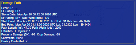
Looks like we had another EF-4 last night. NWS Jackson has done a stellar job with all of this lately!
-
2
-
-
-
-
-
That's a really strong waterspout
-
Just now, Moderately Unstable said:
I'm almost wondering if that isn't a tds actually.
I think the tornado may have been very short lived, but the debris was on the way up and spread out after it lifted. Vrot was around 36 knots for a few scans in a fairly tight circulation.
-
2
-
-
Just now, StormChaser4Life said:
TDS now on that cell now in central LA
Sure looks like it. Touched down about 8 minutes ago and probably tore up a ton of trees.
-
1
-
-
   "The greatest chance for a regional
   cluster of tornadoes is forecast from just southeast of Jackson,
   Mississippi and Hattiesburg, Mississippi eastward across southwest
   and south-central Alabama."
-
 2
2
-
-
Well that sure was fun.
-
1
-
-
Next Thursday might be the Coup de grâce for the southeast

-


Severe Weather for 4/19-4/23
in Central/Western States
Posted
Outflow dominant; future looks bleak for this cell.