

dallen7908
-
Posts
862 -
Joined
-
Last visited
Content Type
Profiles
Blogs
Forums
American Weather
Media Demo
Store
Gallery
Posts posted by dallen7908
-
-
14 minutes ago, WesternFringe said:
Serious question (and I am not complaining- I am excited about any snow tomorrow):
Why does NWS have Staunton in the 1-2" range on their expected snowfall map, but has a 66% probability that Staunton will get over 2"?
Aren't those two things mutually exclusive? They both have the 10:26 am time stamp. As a teacher of math, I am befuddled by this.
63 degrees here NW of Staunton
The probability values are an experimental automated product obtained using output from an ensemble of models. It is one of several tools including models, satellite, radar, and observations used by forecasters when obtaining the forecast value of 1-2".
-
 1
1
-
-
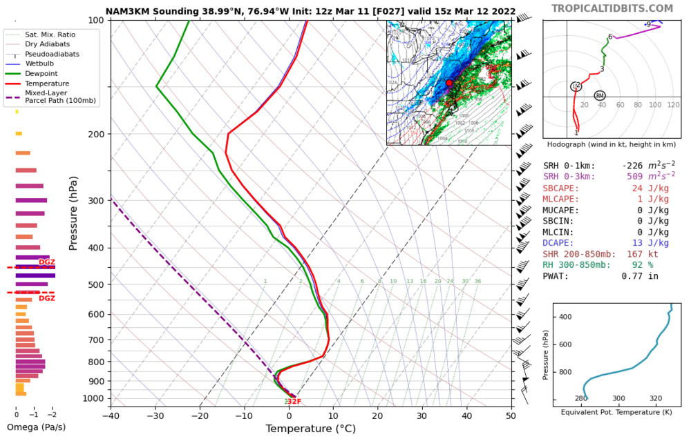
Same plot shown above but for the College Park area. Nice omega within DGZ but as is usually the case; a warm nose to worry about
-
Spring Indeed
63/48 +/- 5 degrees beginning Monday and continuing as far as the ensembles can see ...
-
 3
3
-
-
I was a teenager in northeast Iowa during the 1978 storm;; I spent the evenings listening to coverage from powerful WWWE. I was in the DC area during the 1993 storm; walking across snow/sleet drifts without sinking brought back memories of running across snow drifts as a youth in Iowa.
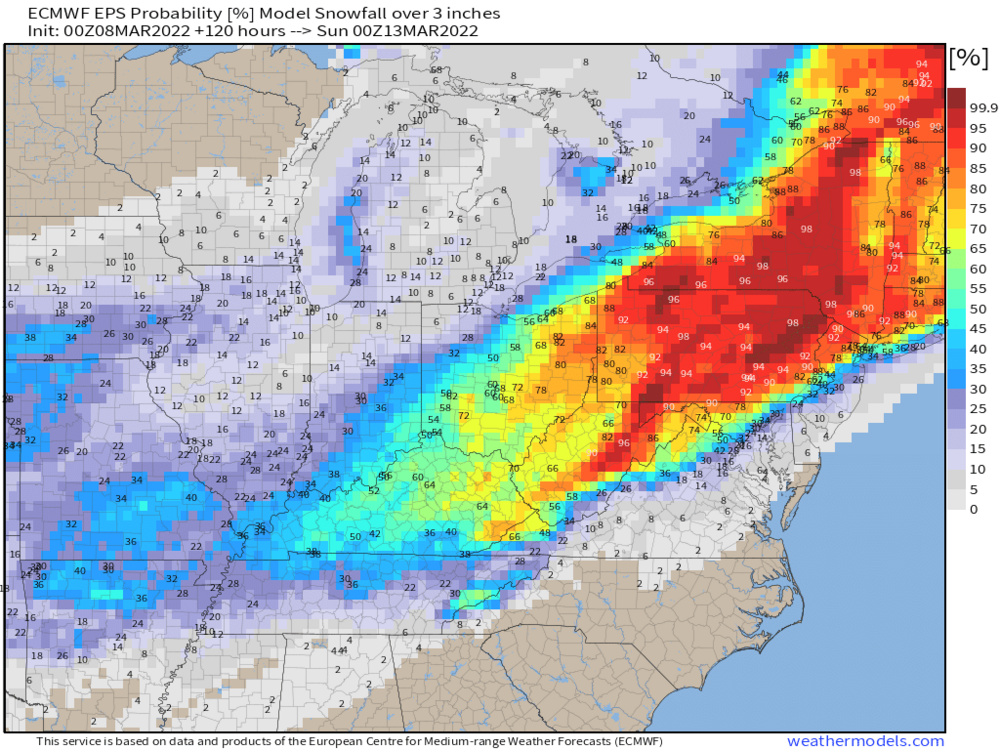
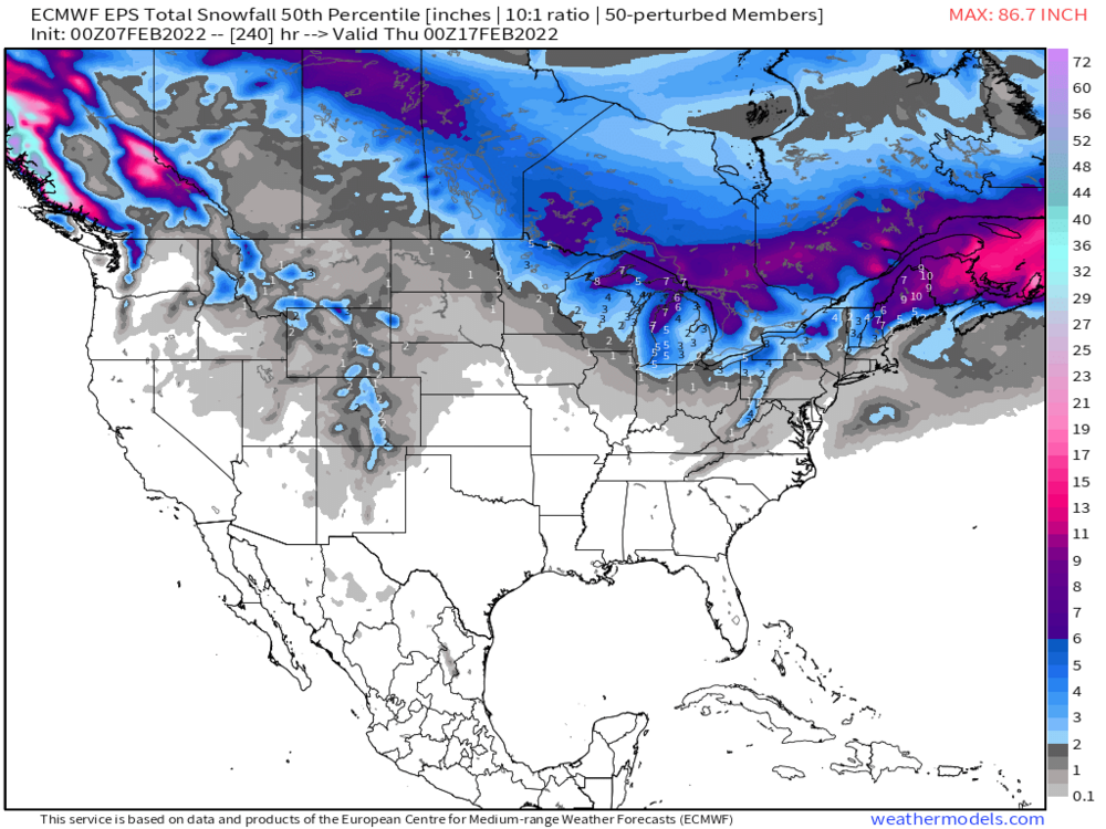
I'm cautiously optimistic that areas in the >50% category (below) will have accumulating snow (> a trace) over the next 5-days.
-
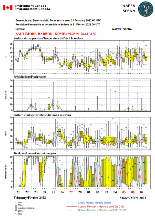
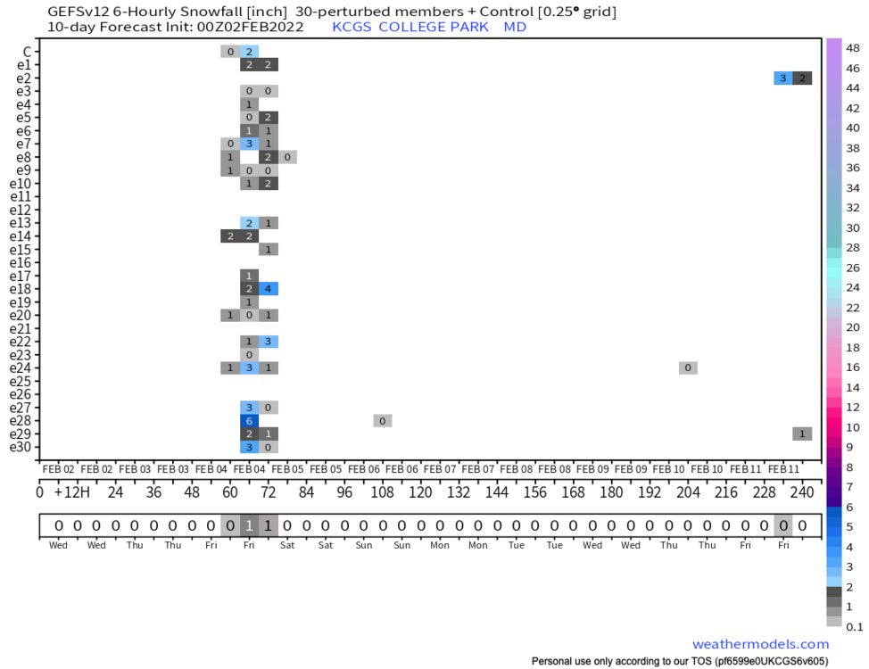
The EPS snowfall mean at College Park for the next 15 days is 0.3" of which 0.1" "occurred" this morning. The mean exceeded the 75th PCTL, which was ~0.15". The GEFS snowfall mean for the next 10 days is also low ~0.1" mostly due to one member which gives us 3" on the 6th.
This is quite unusual for February - in almost any pattern. I'd be nervous to take the "under" of these model "forecasts".
-
... Yes of course the ensemble mean adds little given how non-dispersive the members are and how skewed the precipitation distribution is at range but an ensemble of ensemble PCTLs is still useful, e.g., the 10th, 50th, and 90th percentiles of ensembles based on more than one operational model
-
1 hour ago, Weather Will said:
Latest ensemble runs for snow….

Indeed, the percent of EPS members giving the DC-area > 3" of snow during the 27 Feb - 2 Mar period has dropped to 2% after bouncing between 15 and 25% over 7 cycles (3 1/2 days). Of course, there are only 2 possible outcomes. So if the best you can do is 25% you're probably headed to nada in the end. Hoping for a dead cat bounce over the next cycle or two to keep us interested.
T-3 weeks to Hail Mary time. Hopefully, we'll experience a few "forward breaking waves" before then.
-
1
-
-
You need to squint hard to see the 27 February event at BWI on the NAEFS; a weak signal is seen at Norfolk, VA. The percent of EPS members giving DC 3" of snow/sleet/freezing rain(10:1) through 12 UT March 2 has equalled 22, 14, 26, 20, and 18% over the last 5 cycles (22% value is from 00 UT last evening
-
1
-
-
Guess this is what happens when an inch of (forecast) freezing rain is assumed to be snow. See earlier posts for a more clear but still fuzzy picture of what we may face if the cold-bias of the GFS disappears between now and next Friday.

-
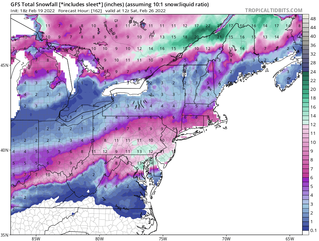
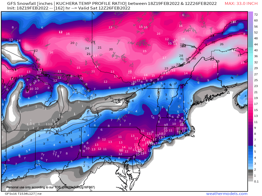
For what it is worth, the percent of EPS members giving DC greater than 3" of snow/sleet through 0 UT Feb 26 (10 days from yesterday evening) has increased from 2 to 8 to 18% over the last 3 cycles (00 UT Feb 15, 12 UT Feb 16, and 00 UT Feb 16). The modeled window for snow begins on the evening of the 24th.
-
1
-
-
1/3 7.5
1/7 2.25
1/16 2.25
1/28 0.5
2/13 0.1" (briefly reached 0.1" when T dropped to 34 during a snow shower just before 9)
12.6" for the year in College Park
"Snow falls and melts continuously on the board. In this case, if the snow never reaches a depth of a tenth of an inch, then a trace of snowfall is recorded."
-
Glad to see "around an inch" in the NWS forecast rather than the dreaded "up to an inch" or "less than a half-inch". Of course the CWG is going with the dreaded "T to 1" for those of us east of the fall line with the latter to cover measurements on "grass and mulch".
Encouragingly much of any accumulation may occur when it is light between 6:45 and 9:00 AM or so.
-
18 minutes ago, psuhoffman said:
There is a system coming through the west next week but its marginal if its going to drop enough snow to be worth a trip out there. Mammoth CA might get a decent dump middle of next week. It looks pretty bare elsewhere.
Mount-Sainte Anne might be an option depending on track
-
7 minutes ago, psuhoffman said:
I’m 10 times more upset that all guidance is showing a huge rainstorm followed by a hard freeze all the way to the arctic circle destroying the surface at every ski resort right better Presidents’ Day weekend. Even out west is a mess where they’ve had little snow in a month. I can’t even find a damn place to ski that will have powder anywhere in the lower 48 next weekend.
"... And every time I hear westerners rag on the “ice coast,” I take pride in the fact that most of them would struggle to ski it. Keeping your edge at 50 miles per hour on ice, feeling the chatter of your skis up your spine, requires more skill than taking face shots of cold-smoke powder.
So, to my uncle’s question: Why would anyone ski the East? For starters, it will make you a superior skier. "
Jay Bouchard from Outside Magazine
-
Trend over the last 4 GFS runs -
-
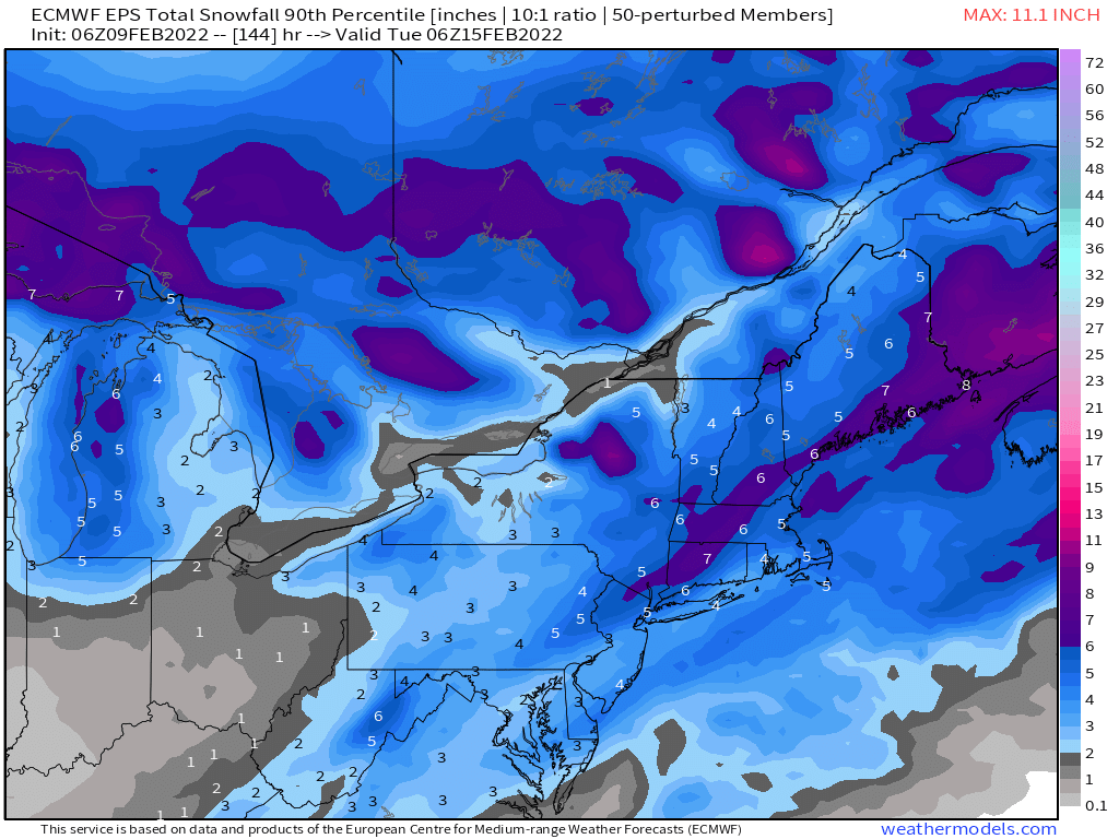
90th PCTL 06 UT EPS snowfall through 1 AM EST Tuesday. The median is 0.5-1.5".

-
Our hoped for Valentine's Day storm is showing up (in the 10-day median) well south of Cape Cod - work to do
-
23 minutes ago, CAPE said:
The ensembles have not been too enthused. But hey we can just ignore that! Op runs will lead the way.

Yes of the 51 EURO ensemble members only one gives more snow than the operational; 46 give less than an inch at DCA
the ensembles like the 18th a bit more but that is way out in fantasy land
-
42 minutes ago, leesburg 04 said:
dang i guess the cold air went on a diet and isn't falling like a fat rock anymore. I wasn't necessarily thrilled with any ice prospects but i did think the huge temp drop would have been fun. Oh well....upper 50's to lower 50's it is....not quite as exciting but at least my sidewalks will get cleaned
Still a fairly impressive T fall on the GFS for DCA. It's just from 56 to 40 degrees (6 to 7 AM tomorrow) as opposed to the 51 to 28 that was forecast 48 hours ago. ... but yes with just one minor wobble (yesterday's 12 UT run was a bit colder at the surface than the 6 UT run) the GFS has trended warmer at DCA for 9 straight simulations.
-
6 minutes ago, StormyClearweather said:
Perhaps we should start a thread on how to name and organize the threads.
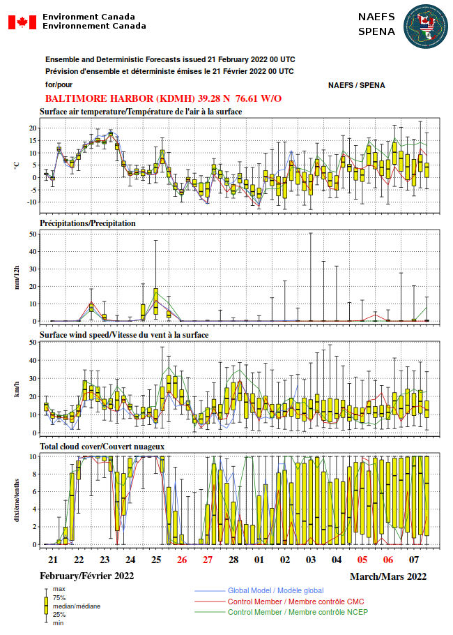
Anyway, not bad in the 10–14-day period.

I like your plot better than mine; day 10-16 for the win
-
 1
1
-
-
5 minutes ago, Baltimorewx said:
I'm still having a hard time believing this for areas SE of the fall line. But you folks with elevation I guess are in store for decent ice event
I agree but us east-of-the_fall liners must keep in mind that each event is unique and simply dismissing each event at a glance because of our climatology is not forecasting, has no skill, and will eventually come back to haunt us
I think an ensemble of regional models may be the way to go now to examine the profiles - certainly wouldn't trust any one simulation of an operational mesoscale model as they are bears to initialize
-
Each run of the GFS over the last several cycles has trended warmer at the surface for DCA. Freezing rain based on Cobb algorithm
00 UT yesterday: Freezing rain with a 3 AM start 7 PM end; 0.60" with 0.27/0.23/0.10" falling with temperatures <26, 26-29, 29-32
06 UT yesterday; Freezing rain with a 5 AM start 7 PM end 0.49" with 0.00/0.38/0.11 falling with T < 26, 26-29, 29-32
12 UT yesterday; Freezing rain with a 7 AM start 3PM end 0.24" with 0.00/0.08/0.16 falling with T < 26, 26-29, 29-32
18 UT ??
00 UT today; Freezing rain with 9 AM start 3 PM end 0.28" with 0.00/0.00/0.28 falling with T < 26, 26-29, 29-32
06 UT today All rain although temperature falls to 32.2 by 2 PM when rain ends
-
The GFS is walking towards the Euro as the Euro runs toward the GFS. Numbers below are for DCA and GFS simulations initialized at 00, 06, and 12 UT
Freezing Rain commences: 3 AM, 5 AM, and 7 AM and ends at 7 PM, 7 PM, 3 PM
Total freezing rain: 0.60, 0.49, 0.24"
% of freezing rain with T < 26: 45%, 0%, 0%
% of freezing rain with T < 29: 83%, 75%, 33%
-
1
-
-
Perhaps some give on the GFS side too.
Verbatim, the surface layer push of cold air to DCA on the GFS is weaker for the 06 UT initialization than 00 UT according to Cobb output.
For DCA, the decrease in temperatures from 1 to 7 AM on the 4th is now 51.0 to 28.3 degrees; it was 36.2 to 25.4 degrees at 00 UT
For DCA, the onset of freezing rain is pushed back to 5 AM on the 4th from 3 AM.
The total amount of freezing rain decreases from 0.60 to 0.49
The amount of freezing rain with sub 26 degree temperatures decreases from 0.27 to 0.00.


3/12 Event: Winters Last Hurrah at Least East of Mountains
in Mid Atlantic
Posted
Just dropped under 40 here in College Park has fallen 9 degrees since 6 AM - moderate to heavy rain