

dallen7908
-
Posts
921 -
Joined
-
Last visited
Content Type
Profiles
Blogs
Forums
American Weather
Media Demo
Store
Gallery
Posts posted by dallen7908
-
-
4 minutes ago, Wxdavis5784 said:
Nah, because he can see the back end coming from the Ozarks.
Well if there wasn't more than a little Ji in us we wouldn't be here 300 hours before game time
-
33 minutes ago, Ji said:
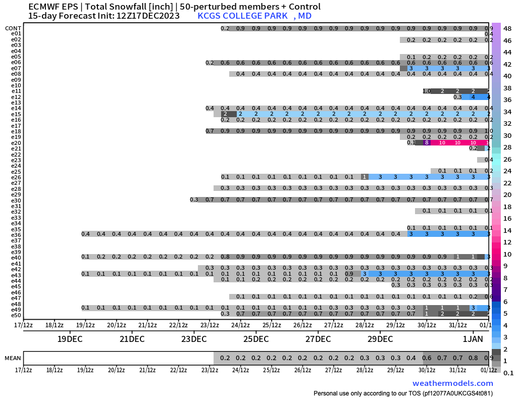
EPS has blue in the snowfall map finally
Yes, the 15-day mean in College Park is over an inch (1.1") for this first time this winter. We're entering a period when the modeled large-scale pattern is favorable and the climatology is less unfavorable. Hopefully, we get a few inches before we hear the word maritime continent again.
-
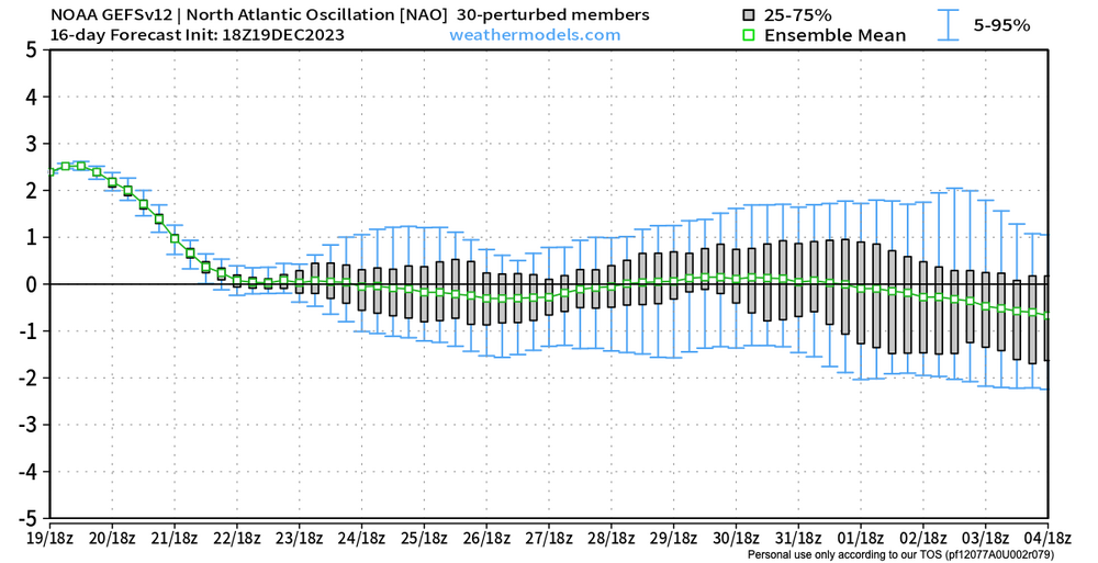
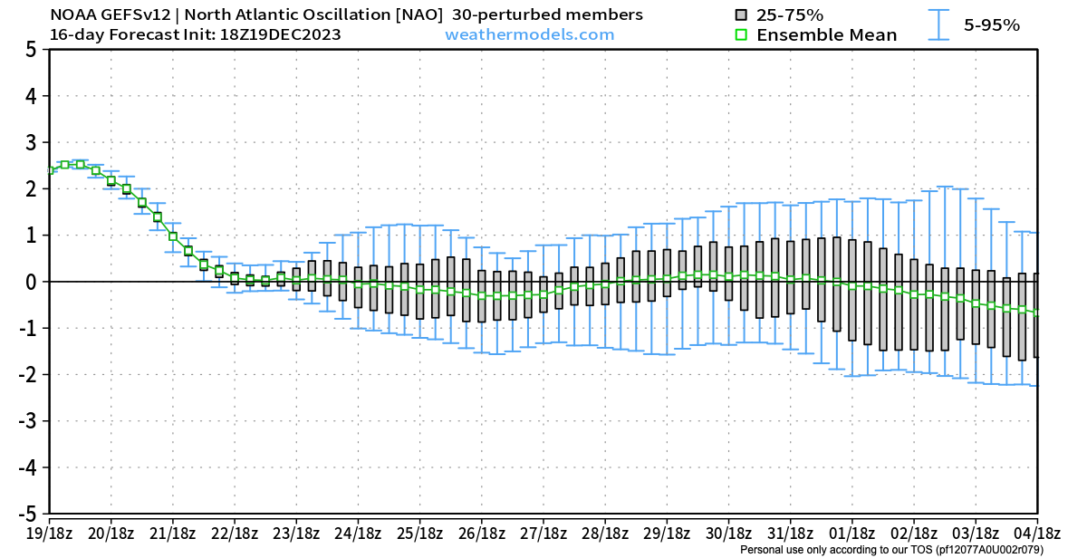
We rock. Perhaps we'll have a storm the first or second day the NAO goes negative!
-
 3
3
-
-
... maybe it's just me but I hope the run comes to fruition and has snow. Despite the "best", "amazing", and "favorable" adjectives, the ensemble mean snow here for the next 15 days is less than 1". I'm certain the analogs are more favorable. ... and yes if the long wave pattern is favorable the snow may come. ... and of course, day 15 is just before our great period

-
 1
1
-
-
https://www.cpc.ncep.noaa.gov/products/predictions/WK34/
Yesterday's NCEP forecast for weeks 3 and 4. Above normal temperatures likely for north-central and north-east U.S. with below normal temperatures in southeast. Transition to colder temperatures in northeast possible some time during week 4.
MJO likely to weaken before reaching phase 8 but could re-emerge in 1.
SSW could impact weather late in week 4
Impossible to predict whether NAO / AO will be positive or negative
Widespread troughing over U.S. due to active storm track and not Arctic air mass intrusions.
-
White XMAS Hope lives for Canaan Valley and Mount PSU?
-
3
-
 1
1
-
-
Yes, the PNA is positive during the last week of December but the NAO also remains positive. On the positive side, approximately 25% of the EPS and GEFS members show a neutral or slightly negative NAO during the last portion of the last week of December. I can't remember the last time there was anything to track during the December 27 - January 1st period. Hopefully, the ensemble 500 means are on to something.
-
3
-
-
I woke at 4:30 AM to snow and 33.9 degrees. After the snow stopped it briefly warmed up a half degree or so before cooling to 33.5 as it cleared just before dawn. Approximately 0.2" here in College Park.
-
3
-
-
1 minute ago, rjvanals said:
Remember that storm which I believe was on Veterans Day of 95 that brought afternoon severe storms and then a massive temp drop that brought sleet then snow. Had maybe ~2 inches from that in Potomac
Yes, I remember it being in the 60s earlier in the day, getting about an inch of rain and then coming out of an early Saturday evening mass with perhaps an inch of snow on the grass
-
I find it kind of pathetic that I'd be ecstatic if 4% of Sunday's predicted precipitation in my back yard (2.5" or so) falls as snow.
-
1
-
-
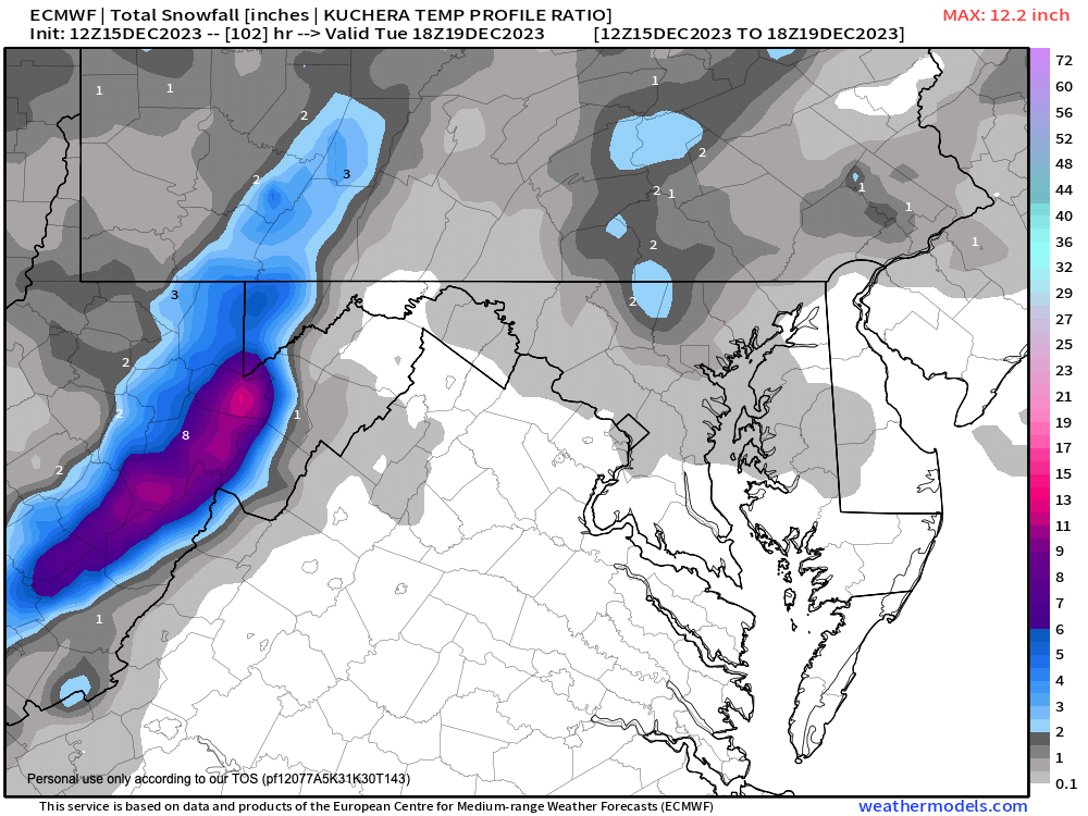
Arguably, the best EURO run yet for north and west of cities.
-
1
-
-
Good luck all! I was supposed to put together a wish list for XMAS but got distracted but wasted by time perusing these articles from the winter of 2023-2024.
Capital Weather Gang: “Thirteen things need to come into alignment to give a big snowstorm to the coastal plain – in a bad year they are uncorrelated – In 2023-2024 R was close to 1!
January 25, 2024 was a January 25, 2000 redux but 50 miles further west .
How to measure snow in a blizzard (hint don't slant stick or you'll lose the stick)
How to make an igloo - the most googled phrase in Maryland last week
Potassium or magnesium chloride: a quick guide
With the five inches Baltimore received yesterday, it joined the 100-inch club
The top ten snowstorms of 2023-2024
Rain-snow line? In 2023-2024 for DC, it was as simple as multiplying by 10.
… and that is why there are 5 categories of a blizzard.
Let's hope for several forum uniting storms!
-
Another great way to experience tomorrow's wind/rain event is to sign up for tomorrow morning's Lake Anna Triathlon, which is still on as of noon today
"Good Morning Giant Acorn Athletes! Yes, we are watching the weather and yes the race is still on. Currently at Lake Anna they are calling for winds out of the north and rain. The Olympic swim will be 2 loops to keep athletes closer to shore. If we need to modify the event further we will. Keeping athletes safe while racing is what we do. Bring layers and a positive mindset! #gokinetic"
-
1
-
-
Here is Alfredo's Climate Bulletin for spring 2023.
Points to highlight for spring 2023 are:1) Spring 2023 was warmer and much drier than normal (i.e., 1991-2020 averages).
2) Spring 2023 precipitation and partial October 2022 - May 2023 water year were both below normal over the state.3) Statewide, spring 2023 was the 9th driest among the 129 springs since 1895.4) A significant warming trend in statewide mean temperature (1.9°F/century) is coincident with a significant decreasing trend in statewide heating degree-days (-162.57°FDD).5) An increasing trend in the statewide partial October-May water year (2.31 in/century) is also found.6) Regionally, mean temperature in spring showed a significant warming trend everywhere in the state, with maximum values over the Eastern Shore (above 2.0°F/century) and Baltimore City (2.8°F/century).
7) Regionally, accumulated total precipitation in spring showed significant increasing trends in two regions: Allegany County (1.4 in/century), and Baltimore and Harford counties (1.8 in/century).The seasonal bulletin is issued quarterly to indicate the state's recent surface temperature and precipitation conditions in a simple format, allowing Marylanders to understand regional climate variations better.This publication is part of our efforts to make the Maryland State Climatologist Office more visible across the State and be central to all discussions of regional climate variability and change.Please help disseminate this bulletin.Thank you,Alfredo (MD State Climatologist)-
3
-
1
-
-
Good Afternoon,We now share the May 2023 Maryland Climate Bulletin. You can access it from the following link:Points to highlight are:1) A colder and drier than normal May.2) The largest deficits in precipitation occurred in the counties of the Piedmont.3) Drought conditions occupied around 66% of the area of the state. Moderate drought conditions appeared in Charles and Prince George's counties and portions of Montgomery, Howard, Anne Arundel, Baltimore, Harford, and Cecil counties4) Long-term trends (1895-2023) show significant warming trends from Washington County to the east. Notably, the largest trend (2°F/century) is over Baltimore City. Significant precipitation trends (above 1.0 in/century) are present in Allegany, Garrett, Frederick, Montgomery, Howard, Carroll, Baltimore counties, and Baltimore City.5) Statewide precipitation was ranked 8th among the driest Mays since 1895. However, Baltimore City, Baltimore, and Howard counties recorded the driest May.6) A significant warming trend in statewide mean temperature (1.0°F/century) is coincident with significant decreasing and increasing trends in statewide heating (-18.4°FDD) and cooling (15.9°FDD) degree-days for the period 1895-2023. A significant wetting trend (0.77 in/century) in statewide precipitation is also present for May.The bulletin is issued once per month to indicate the state's recent monthly surface temperature and precipitation conditions in a simple format, allowing Marylanders to understand regional climate variations better.This publication is part of our efforts to make the Maryland State Climatologist Office more visible across the State and be central to all discussions of regional climate variability and change.Please help disseminate this bulletin.fromAlfredo
-
2
-
-
Here is the April 2023 Maryland Climate Bulletin prepared by state climatologist Alfredo Ruiz-Barradas
https://www2.atmos.umd.edu/~climate/Bulletin/bulletin_mdsco_current.pdf
Points to highlight are:1) Warmer-than-normal conditions still persisted in the state since the beginning of the year. Wetter-than-normal conditions appeared on the western and eastern shores.2) Statewide warm anomalies increased from March, and dry anomalies changed to wet anomalies.3) While the extent of the surface under drought conditions (abnormally dry and moderate drouth) decreased from March to April, abnormally dry conditions developed to the west of Washington County.4) Most counties had mean, maximum, and minimum temperatures within the top five warmest Aprils since 1895. The statewide maximum temperature was the warmest on record, while the mean temperature was the second warmest.5) Significant, century-plus (1895-2023) warming trends are identified over the state, especially over Baltimore City (3.9°F/century). However, significant wet trends are only found over Allegany and Garrett counties (0.6 in/century).6) A significant increasing trend in statewide mean temperature (2.8°F/century) is coincident with a significant decreasing trend in statewide heating degree-days (-84.21°FDD).The bulletin is issued once per month to indicate the state's recent monthly surface temperature and precipitation conditions in a simple format, allowing Marylanders to understand regional climate variations better.This publication is part of our efforts to make the Maryland State Climatologist Office more visible across the State and be central to all discussions of regional climate variability and change.Please help disseminate this bulletin.Thank you,Alfredo-
3
-
1
-
-

Wish I were in the Palisades or perhaps preparing for tomorrow's Classique Alex Harvey at Mont-Saint-Anne. Weather looks great after today's snow showers tomorrow's high is expected to be 32F.
-
11 hours ago, Maestrobjwa said:
Tbh I feel myself losing interest...I'll bet this board goes the way of the SE forum if we continue to have winters like the last 7 years. I don't know about anybody else, but I came here and was drawn to the science of it for the snow. Without that, or with it becoming increasingly difficult and even less of a ROI than it was in what used to be a "bad" year before this drought.
When I started at NASA-Goddard in the late 1980s there was still an ice skating club and a sign telling you whether the pond was safe for skating. I believe the last time any skating occurred there was December 1989. It was years before it was cold enough to skate there again and by then the club and sign were just memories. I'm probably misremembering but I believe the last good skating weather was February 2015.
-
Yet another excuse if 2023-2024 fails to deliver.
"When Hunga Tonga–Hunga Ha‘apai (HTHH) erupted in January 2022, it shot the standard volcanic cocktail of ash, gas, and pulverized rock into the sky. But the eruption included one extra ingredient that’s now causing climate concerns: a significant splash of ocean water. The underwater caldera shot 146 metric megatons of water into the stratosphere like a geyser, potentially contributing to atmospheric warming over the next 5 years, according to a new study published in Nature Climate Change.
The model calculated the monthly change in Earth’s energy balance caused by the eruption and showed that water vapor could increase the average global temperature by up to 0.035°C over the next 5 years. That’s a large anomaly for a single event, but it’s not outside the usual level of noise in the climate system, Jenkins said."
-
They must have really tweaked the IC on this EPS
 ensemble member.
-
1
-
-
2 hours ago, WxUSAF said:
I’d be very good with 3 months of deep winter, 1 month of summer, and 8 months of 65-80F.
Did you check out the Washington Post today. Apparently, Alaska is the #4 retirement "destination" in the U.S. behind Arizona, California, and Florida. You'll have company.
Surprisingly, to people on this list, desire for snow is not believed to be the main reason.
-
1
-
1
-
-
11 minutes ago, stormy said:
Preponderance of evidence at 180 hrs. suggests a high probability of a Miller A storm on the east coast early to mid next week. Credible details are impossible at this range. Confidence should be much better by Saturday.
Regarding the GFS snow maps. If the storm brunt reaches north and west to our latitude, heavy snow would be possible from the Blue Ridge westward through the 81 Corridor into the Potomac Highlands. Significant accumulations (more than 3 inches) would be unlikely for the 95 low lands.
Good to hear. One more in the unlikely camp versus the snowball chance in hell camp.
-
It's interesting that only one of the 31 06 UT GEFS members shows measurable snow around the 23rd in College Park. The 10-day mean snowfall for my backyard is about a 1/4 inch. Early-April numbers.
While this could be chance, It really illustrates the fact that the parent model of the ensembles is not the operational model. It is an older version of the operational model. Hopefully the improvements matter here or perhaps the resolution.
-
EPS 10-day snow mean in my back yard for the last 5 runs: 5.5", 3.6", 3.2", 2.3", and today 12 UT 1.2". Tonight the rebound begins.

Dec/Jan Medium/Long Range Disco
in Mid Atlantic
Posted
Way too early to give up on early January but here is the 3-4 week outlook beginning on the 6th. Features 55-60% chance of above normal temperatures and the same chances for above normal precipitation. It's a two outcome prediction so the chances of below normal temperatures is 40-45%.
They note that the AO may go negative as early as mid-January if a SSW occurs. They believe the dominant forcer will be the strong ElNino and are not putting too much weight into the MJO due to large uncertainty.
https://www.cpc.ncep.noaa.gov/products/predictions/WK34/