

Stevo6899
-
Posts
2,521 -
Joined
-
Last visited
Content Type
Profiles
Blogs
Forums
American Weather
Media Demo
Store
Gallery
Posts posted by Stevo6899
-
-
Toledo bullseye. Crazy the gfs still spitting out 30+ kuchera totals. And the band got wider on the 0z. Curious to see if weve hit the northern most extent of the heavy 30+ banding.
-
2 minutes ago, Chicago Storm said:
0z RGEM with a big jump north with the main storm system, but still south of the GFS/NAM.
What the hell happened to the ukmet? Its been way way south the whole time. Did they run some kind of update on it and now its scores arent as good? I remember it having the best verification scores as recent as last yr.
-
 1
1
-
-
Just now, RyanDe680 said:
I’m telling ya…. Just wait until 24 hours out. Saves you the stress
You'd think id learn after 17 yrs of this, and after ghd1 but a weenie gonna weenie. I dont get as stressed as I used to. Just been waiting forever for our own ghd 2 footer in metro Detroit. Maybe this is it.
-
3
-
-
Just now, Chicago Storm said:
There are several pieces to the puzzle.
PV well north up in Canada, a disturbance currently cut off well offshore of California, lead waves coming onshore in BC/Pac NW, and then lastly another wave that will dive into the Pac NW from Alaska.
Yikes. I think we can see why so much volatility in the model solutions today, and prob more on the way. Gonna be a long 48 hrs lol.
-
2
-
-
2 minutes ago, michsnowfreak said:
Are you flying home?
I was gonna wait until tomorrow night to book my flight. Cant trust these models enough until within 36 hrs lol. Would prob fly home late tues night. Was thinking maybe even wed morning but not risking getting it cancelled since it looks like it may start wed morning. Airlines are weak nowadays, delta used to never cancel flights unless a blizzard. Now all it takes is a couple inches.
-
2
-
-
Where is the energy from the main show coming shore? Pac nw? SW?
-
Just now, Powerball said:
Not only that, but to provide more buffer, it's sitting squarely in the middle of the southern UKMET/GGEM and the northern Hi-Res models.
I agree that DTW is sitting in a good spot for the front end snows and the main show and has a chance to see some of the higher totals. Im just happy theres something to track. Basically 3 months of no big dogs to track so far.
-
2
-
-
Just now, Hoosier said:
I don't know... I'd be pretty nervous if I were on the southern edge.
Especially after the rug pulling ghd1.
-
1
-
-
2 minutes ago, Powerball said:
Verbatim, DTW's still all snow at the end of the run, but yeah that sleet line is close for sure.
Gotta smell the rain to get the big snows i suppose. It was looking like dtw was safe from even a north shift but who knows now lol. I was hoping the models would get their act together by the morning so I can book my flight home for this if needed. My family and friends cant believe i would leave 80s n sun for snow lol.
-
1
-
-
Firehouse of snow lined up from maine all the way back to new Mexico hr75 on nam. Incredible developments the past 12 hrs, most noticable the orientation of the band in a nw/se trajectory. N IL and central Michigan reeling it in.
Mixing issues almost all the way up to dtw.
-
3
-
-
1 minute ago, Floydbuster said:
That would totally suck for show junkies in Northeast Ohio.
Didnt they just get like 18 inches with the last storm?
-
2
-
-
Looking around at the local offices grahics that were made today (dtw/cle/grr/nind), most look like they are favoring the gefs ensembles/northern solution.
-
1
-
-
1 minute ago, Harry Perry said:
GRR completely throwing the storm away that affects 75% of the CWA 72 hours out.. might not end up with an advisory at all, just 6-10” of snow haha.
Even the EURO they’re riding to the grave shows appreciable snows across 50% of their CWA so their statement in this mornings AFD just shows how erroneous certain forecasters can be if it doesn’t affect their backyard.
I think they are riding the trends the past few years of respectable snowstorms sliding to our SE and the lack of nw trends. Either way still reckless to have this point of view of this storm at the current moment. Dtw/grr are the worst.
-
 1
1
-
-
15 minutes ago, Chicago Storm said:
12z Euro looking north early. Higher heights in S Ontario/Lakes/OV/MSV, and lead wave is further north when coming through.
Also, Western US trough is more consolidated/organized, deeper and is less strung out/elongated.
It won’t be the 12z GFS, but it’ll be a step that way.Not gonna end up close to the gfs, which at the moment is on its own, op runs wise.
-
8 minutes ago, KokomoWX said:
19" IMBY - A pure dream.
Wow it's definitely been too long. I hope this one works out for you.
-
5 minutes ago, RogueWaves said:
IF we were looking at a wound-up strong SLP like back in 2011, then yes Chicago. I think this is suppressed due to weaker SLP not able to push back on CAA,
Yeah like with every storm there's a lot of factors of play. I think the colder air and high pressure to the north is definitely hindering this from cutting much like ghd1 did. I still think there can be some wobbles nw, i feel like if we're gonna miss this one it's gonna be to our Southeast. Climo didn't favor us missing last week's Cleveland and Toronto blizzard to the Southeast so I think we can throw that logic out the window.
-
1
-
-
7 minutes ago, KokomoWX said:
GHD I was expected to be a monster for the LAF-OKK crew. Instead a last minute sleet storm happened and Chicago got a historic snowstorm. Here are a few maps and images I have from leading up to that event. You can see the bullseye was everything we dreamed. Long live the DGEX. (I forget who used to run a private high resolution weather model for our area.)
Ughh what a nightmare that ended up being, hearing the sleet. Thats why i like where we sit right now with the euro being further SE. This time around though, theres not a wound up low like ghd1 so I think a big nw trend last minute is less likely and last nights euro has a better chance of verifying. Hopefully the zone from laf/fortwayne/dtw can cash on this one and redeem ghd1. Its weird how we find a storm threat almost every yr around groundhog day.
-
1 minute ago, Hoosier said:
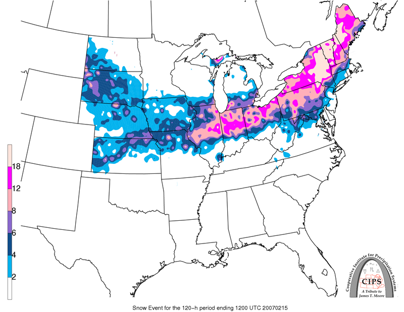
It's clown range of course but that is a pretty wide band of 2'+. Few storms in this region have pulled off such a large area of 2 feet. Typically it's an isolated pocket or a very narrow band when it does occur.
I wonder when the last time we saw these kind of totals involved in a setup where there wasn't really a wound up low pressure system. Euro backed off the deeper low, but upped the totals. Just shows what the an open GOM can do.
-
I'm curious to hear what the met's think how far Northwest this thing could track. Or if a ukmet like track is more likely.
-
Euro gonna be as good as it gets for detroit. Too bad its so far out. Still good to see its a respectable event still.
-
1
-
-
1 hour ago, Powerball said:
Several weeks ago, @Stevo6899 did predict that Chicago might end with 10" more for for the season than Detroit, when all said & done.
This storm, as currently depicted on the models, would definitely be the one to test that prediction.
The gfs and Canadian are keeping the the low pretty weak, whereas the euro gets its sub 1000. Either way looks like the biggest potential weve had all winter with an impressive baroc zone setup and dont need a strong low as others have stated. The hp will definitely keep this from going to far nw. I like where chicago to detroit sits. I think once the noreaster moves out in a few days, models will hone in better on it.
12z ukmet is furthest SE, delivering the goods to indy through ohio.
-
41 minutes ago, dmc76 said:
You’re an idiot
is this your first day tracking weather? Have you not figured out how clippers work. There’s always an isolated area that always over achieves. It’s called banding. All you do is come in here and troll Josh all day. Get out of your little Clinton Township bubble and come north a little bit and see for yourself.
Im actually a florida snowbird now. Perhaps getting out of that shitty climate once in awhile will make you a happier person. Nobody saw over 5 in yesterdays clipper, let alone 6-7 as you said. Just calling it like i see it. Nobody calls out joshs turd polishing so i do it. If he did it less i wouldnt need to troll him so often. Same with joes bullying. I wasnt up north last year so perhaps I missed this big dog alek is talking about, but my guess was it for the chicago region and it weakened as it approached dtw. Just the way it is mostly as dtw is often stuck in the transfer energy to the east coast zone. Other than that, nobody can deny the trend for storms to weaken as they head east the past 3-4 winters. Havent had a ghd type, nw trender is awhile. Not sure why I need to take a seat for calling it like i see it. Anyhoo y'all enjoy your useless cold and dry.
So last 5 years, dtw is averaging less than 1 storm a yr that drops 9". Thats terrible. Thats gotta be below almost all other areas in the region.
-
Just now, michsnowfreak said:
Some weaken. Some don't. Always been that way. Can definitely name multiple events the last 4 years that didn't weaken lol.
Again I'm talking the more legitimate events. Sure maybe a few clippers that were forecasted to be dusters, may have dropped 2-3, but the bigger potentials have all been weakening turds by the time they get to dtw. I miss the nw trend days and cant believe im saying this but the sleet that came with it. Atleast those events have some fun days of tracking, and legitimate snow somewhere in the region. The lack of organized snowstorms in the whole region the past 4-5 winters has been hard to believe.
-
8 hours ago, dmc76 said:
Near 6” around here. Some spots in Rochester had close to 7”.
Yea i dont buy any of that. Nobody got more than 2-4 yesterday. Maybe a isolated 5 in the higher oakland terrain.
-
 1
1
-
Feb 1-3rd GHD III Part 2
in Lakes/Ohio Valley
Posted
You never wanna be in the bullseye 36-48 hr out. Id rather be on the northern fringes so i like where detroit sits. More often than not, banding ends up further north. Ill wait until tomorrow 12z to book anything.