

baltosquid
-
Posts
531 -
Joined
-
Last visited
Content Type
Profiles
Blogs
Forums
American Weather
Media Demo
Store
Gallery
Posts posted by baltosquid
-
-
RGEM looks a bit south with the first wave compared to 18z, best precip at DC latitude.
-
FWIW, the 3km is further north than the 12km.
-
13 minutes ago, Cobalt said:
That actually just seems to be from wave 1. A decent slug of precip/snow falls (at least according to the GFS/Euro) after 0z Friday, and that runs up until 7pm Thursday.
True, probably smart of them to give it some time to figure out totals for that while the models bicker about whether that second bit is south or north.
-
1 minute ago, psurulz said:
I'm a newbie and don't understand how the storm on the 14th is allowed to cut rather than get forced under the block?
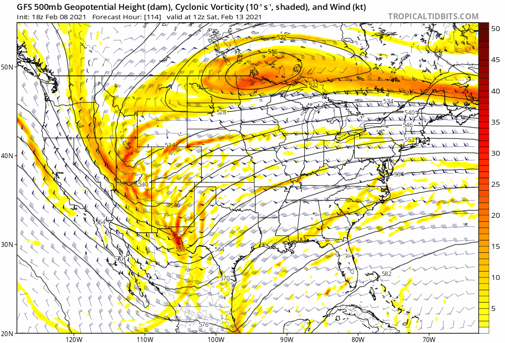
Someone with actual weather expertise can probably explain this better than I can, but I believe this giant 500mb feature is the culprit. Our storm rounds that through the Great Lakes, while in the previous run, it was positioned a bit further south and east, so when the storm came round, it was in a better spot for us (still was only an ice storm though).

-
 1
1
-
-
Just now, catoctin wx said:
Hadn't seen this posted yet in this thread. Apologies if I missed it and this is a duplicate.
Seems like a good forecast based on climo for something like this, even if there is some potential for better totals for DC and south.
-
1
-
-
That's another trend south with the fringe for the GFS, so while it may not be a good run for those SE of I95, maybe the next one will be?
Edit: Was mistaken, thinking about the 06z.
-
GFS coming in drier, a tad south perhaps.
-
Just now, midatlanticweather said:
If my memory serves me (and it may not) waves like this are usually 3 to 5 inch events (higher in the higher spots).. So we get two, which would net 6 to 10 inches (maybe?).. I would think. A long while ago in the early 90s (yep..) I remember tracking one of something like this and it was a 3 to 6 inch event .. I was an intern at the Climate Analysis Center at the time... but it quickly moved through. So two, seems like a double of the same thing. On to the model analysis!
Jackpot of 10 seems pretty reasonable if you get something like the euro. Gut says somewhere in the latitudes between DC and Baltimore gets it.
-
ICON really loses a lot of the precip from the previous run. Once you get north of DC, you go from 0.5, to 0.4, to 0.3 in Baltimore, and less and less as you keep going. Still a good run to have at this stage if you expect a north shift and aren't looking too deeply at rates quite yet. But dryness is still my biggest worry.
-
Euro has us in the game for weekend tracking. Ice storm right now though.
-
1
-
-
What would it take to get that precip shield to expand/strengthen? That seems to be what's keeping this from being great everywhere per the Euro - not that it isn't good already.
Edit: was looking at 10:1, kuchera looks much better, disregard!
-
Euro looks like it wants to merge the events into one marathon.
-
Don't forget the CMC is coming in now too. Surface looks warmer leading in to Thursday so far. More of a SE ridge.
-
1049 High on the plains as the ice storm rolls through.
-
Ice storm... but we're getting there. Give it a few more runs and let's see where it goes. Thursday started as an ice event and it's a lot better now.
-
Cold air, meet gulf moisture.
-
Doesn't quite capture every last little bit of snow in the eastern part of the forum, but the GFS thru Thursday looks like a good tick in our favor. Give us one or two similar ticks and most of us should be in a good spot, but it's gonna be a nail biter somewhere regardless.

Edit: a few more inches to come on Friday.
-
1
-
 2
2
-
-
SW winds at 850 look weaker on the GFS at hour 60 so that's better, and temps look better at that layer. Precip is further south. Could be a good adjustment.
-
1
-
-
My biggest worry at the moment isn't south/north but rather lackluster rates and dry slotting like we saw in the thump two weeks ago. If that happens, then we need to hope the Friday shot some of the models like works out, and we've seemed to do poorly in the back half of our storms lately. Would much rather just have a stronger thump than rely on a departing hit.
But we're well out of the range where we'll be able to pick out specific regions of lackluster precip so while it's my biggest worry, it's still a small worry. Only really based on how prior storms have gone this winter.
-
Bet the national blend of models looks pretty, pretty good right now for central MD. Pretty much right in the middle of all the big models.
-
2
-
-
4 minutes ago, Scraff said:
Larry Cosgrove = Pants Tent
 “There is no fighting the notion that most of the lower 48 states are going to get swept up by the Arctic regime now descending from Canada. But there are questions about storm potential, especially regarding track and type of precipitation. Let me remind you that all of the numerical models show at least one massive disturbance passing out of the southern Rocky Mountains in the 6 - 10 day range. The ECMWF scheme is reluctant to allow the intense cold to reach the southern and eastern tier of the nation, which the GFS series is more aggressive and brings the forward edge of the cAk readings all the way into the Interstate 10 and 95 corridors. In effect, only California and Florida dodge the proverbial bullet.It has been my experience that the American scheme handles cold advection much better than its European counterpart, particularly when a true Arctic air mass is involved. It is a judgment call, but the regime over North America is arguably the coldest in the Northern Hemisphere and will continue with that dubious title for the rest of the calendar winter. This is important because the path of storms in the medium range will likely be suppressed into the northern Gulf of Mexico and then up or off of the eastern Seaboard. I can see a scenario where the southern rim of the U.S. has a rain ending as an ice event, while snow deepens from the Great Plains into the Mid-Atlantic and New England states. Much of this is up for grabs, mind you, but the emergence of renewed blocking in Greenland, agreed upon by all of the computer models, will favor a lower latitude trajectory of impulses in the Arctic, polar, and subtropical jet streams. And the most obvious candidate is the broad cyclonic circulation below the Aleutian IslandsI note that most of the ensemble packages show yet another shortwave from the northern Pacific Basin getting caught up in the deviated jet stream configuration, with another deepening storm in the Southwest seven days from now. We have to watch this feature carefully! I can see a track scenario taking shape where the system drops into northern Mexico, then moves along the Gulf Coast,m and then close to and likely just to the right of the Eastern Seaboard. around February 14 - 17. This is the type of set-up that -could- produce a true monster winter weather event, with the Arctic motherlode being pushed into the Great Lakes region and phasing with the low pressure area. The vast expanse of cold is worrisome since actions like overrunning and cold instability will interact, with a wider coverage of precipitation types than is normal”
Yeah the models have been flirting with some big moisture coming up from the gulf for a bit and it has piqued my interest for sure over the past couple days paired with the cold coming. Classic case of give me the ingredients and let the details work themselves out.
-
1
-
-
UKMET onboard for some thump on Thursday. Big euro run coming up, would be a pretty strong group of models onboard if it joins in.
-
Changeover complete at Patterson park, all snow right now, but flakes could maybe get better as things go on. No accumulation so far.
-
1
-
-
I'm very intrigued by next weekend. A ton of cold on the GFS in particular and something maybe coming up out of the Gulf after the midweek event. Canadian and Euro ops aren't as on board with the cold and keep it out west, especially the Canadian, but their ensembles are much more favorable to it. H5 look needs a lot of work, but maybe there's time.
February 10-12, 2021 Winter Event
in Mid Atlantic
Posted
CMC is onboard with the euro progression of the second wave. Really good run for a lot of the forum. Two waves are closer together and the second is much stronger.