
Steve25
-
Posts
628 -
Joined
-
Last visited
Content Type
Profiles
Blogs
Forums
American Weather
Media Demo
Store
Gallery
Posts posted by Steve25
-
-
1 minute ago, LeesburgWx said:
What happens if we switch and get GFS/ICON on our side but then Euro/CMC against us...
Anarchy
-
 3
3
-
-
1 minute ago, WVsnowlover said:
There's going to be a lot of breath holding until the 12z Euro rolls out after that run
Let’s be honest here, even if the Canadian showed a monster, everyone still would be living or dying on the Euro
-
3 minutes ago, mitchnick said:
24hr Eps
.thumb.png.522e2b92ecf4ffdaf8e7a3d48816bf63.png)
Looks like it brings the best of accumulation east of the OP, but not drastically. Still great!
-
 1
1
-
-
16 minutes ago, yoda said:
After Tuesday night disaster at work (I work at Amazon and we had to stay open because DCA1 said we're sending you 5k of packages in two trailers) - and trying to get to work was a disaster in itself - I've already flagged next week with our management/operations team.
Plus our bozo day shift said hey we're going to leave all your carts outside... so they are covered in snow and ice and not bring them in because... we didn't feel like it. And there's over 250 of them. It was not a fun 4 hours the next night.
Hey, I work at DCA1! Sounds like a nightmare
-
1
-
-
BE STILL MY BEATING HEART!
-
 1
1
-
-
3 minutes ago, Maestrobjwa said:
Yes. Now the only caveat is Jan 2022. OFFICIALLY, BWI measured 6.1". But we didn't make that here in the city itself (I think I measured 4"). It has been a pretty brutal stretch...while this may be the best 9-year stretch DC/NOVA has had when it comes to jackpotting.
So now you see why those of us in that area have been more frustrated!
I don’t think “pretty brutal” does this stretch of years service, specifically around Baltimore. I think a strong argument could be made that this is the worst stretch of winters BWI has ever had in the history of record keeping, in terms of snowfall. 8 consecutive winters with total snowfall under 19 inches coming into this winter. That has never been done before. BWI went 7 winters in a row one other time in history, but even during that stretch, they only were held to single digits once. We’ve been held to single digits 3 times in the past 8 years. One of those being literally our worst winter of all time, with the 0.2 inches in 2022/23. There are 8 and 9 year old children who live around here who have no clue what a legitimate snowstorm is like. We’ve had a couple storms around Baltimore during this stretch where if you happen to measure in the perfect spot, you may scratch the surface of 6 inches, but that’s been the max for 9+ years.
To say we’re due for a big one at some point is an understatement.
-
 2
2
-
-
The thing I don’t understand are the people saying the pattern change keeps getting pushed back. PSU, along with some of the other intelligent posters in here have been saying for a while now that the real opportunity for something significant will be around the 18th or later, if I’m not mistaken. They seem to not have budged off of that. They even said that anything before that has some potential, but that it’s messy and no real opportunity for a big one.
I understand that people would prefer to cash in on ANY type of potential, and that the earlier in February climo the better, but the sentiment that the advertised exciting period keeps getting shoved back seems wildly misunderstood and exaggerated.
-
4 minutes ago, Maestrobjwa said:
Whoa, whoa...y'all are giving up on the pattern change already because of what, exactly?
Because they’re weenies
-
2
-
-
12 minutes ago, DarkSharkWX said:
nod to cmc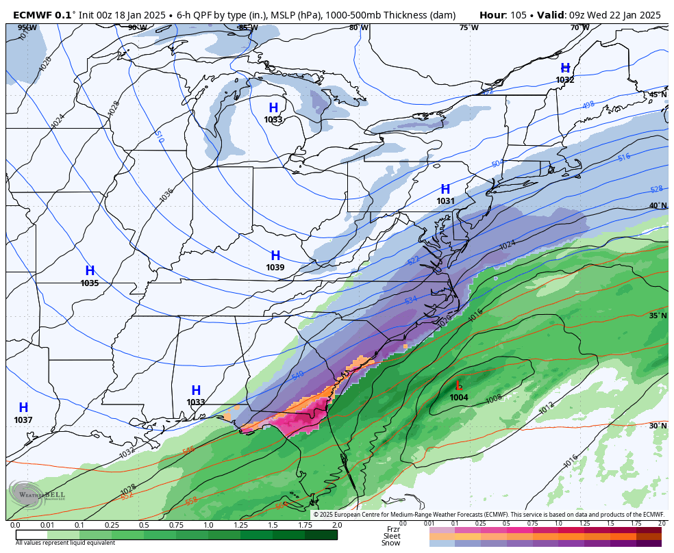
All my weenie eyes can see is that a formidable jump NW and this turns into a mega-cold, beautiful snowstorm.
I don't know the pattern details like you guys, so I don't even know if it's realistic to think it could come NW, but man
-
1
-
-
23 minutes ago, Terpeast said:
Big difference this time is we’re tracking another potential snow event instead of staring down an 80 degree day in January like last year
100%. Even with the lack of a BIG storm, it actually feels like winter this January!
-
4 minutes ago, Terpeast said:
That is true, but when trying to retain snowcover till the next storm, it is annoying when it shoots up into the 40s.
Funny, I didn’t think I’d say this in what looked like an incoming -enso -pdo +qbo torch of a winter where one of the top analogs was 22-23, where we couldn’t even get below freezing half of those nights!
Yeah, I mean I get it, but I got 6 inches from the last storm and I'm still seeing a fair amount of it around 10 days later. Hard to complain about that. Now, the scraps will likely melt the next two days, but then hopefully get replenished on Sunday before our next extreme shot of cold.
-
1
-
-
14 minutes ago, aldie 22 said:
I haven't been paying attention with all of this cold talk...are we really hitting mid to upper 40s Friday and Saturday?

That's not far from average for this time of year
-
24 minutes ago, WEATHER53 said:
Anybody have the projected highs and lows for DCA snd BWI during the 2-3 day very cold intrusion ?
The overall look is that we drop to around 20 degrees as the sun rises Monday morning, really don't rise at all during the day Monday. Then mid-teens for highs both Tuesday and Wednesday, with lows in the single digits.
Likely at least 72 consecutive hours under 20 degrees.
-
1
-
 1
1
-
-
Has anyone mentioned that the CMC has Baltimore at NEGATIVE 12 degrees next Thursday morning LOL
-
1
-
-
One thing the GFS and Euro agree on is that the high temp around Baltimore on Tuesday will be 12/13 degrees, and that we drop below 20 Monday morning and don't climb back to 20 until Thursday.
-
1
-
 1
1
-
-
I've seen a few people saying the potential pattern around the 20th and beyond reminds them of 2013/2014. Can someone remind me of the storms we got during that time? I know there weren't any huge storms, but the winter overall was well above average. Was it a bunch of like 4-8 inch events?
-
23 minutes ago, mitchnick said:
S&E again with the system. Ughh
I say this with all seriousness, do you really want the GFS showing big hits 7-10+ days out? Almost feels like the kiss of death recently. Just look for signs of cold air with storm activity in the vicinity at this range.
-
2
-
-
Driving from Baltimore City to Bel Air from the bars just now was treacherous. All roads were caved, not excluding 95. It was not the most fun drive, but made it safely.
-
1
-
-
5 minutes ago, Maestrobjwa said:
I'm gonna be blunt: You've gotta let it go, man. Once it's clear a threat won't work out, just make like a punter and well...punt! Don't spend another ounce of mental energy on it. It'll drive ya crazy--trust me, lol Distance always helps after a threat doesn't materialize...So perhaps now may is the perfect time for a break from here

Oh, I'll definitely let it go. It was just a quick thought I had in a weak moment and I thought if there was anywhere I might be comfortable sharing it, it would be in here. I'm on to the next period of interest.
-
Is anyone else kind of down that this next storm system is just going to graze by? I understand there are factors in play that are leading to this result.
I just can't stop thinking about how a week ago all the talk was about how the second week of January was loaded with potential, with the big fear being that it would be too cold and lead to suppression. Now here we are, into the second week of January and we're about to have a significant system moving through the south, and we're not in some unbelievable, brutal cold airmass, yet...it's still not going to work out. I just keep thinking, man, if that thing could just hit the coast and ride up. Feels like this could've been the one to take this January from okay to GREAT. I'll continue to hope for around the 20th and beyond, but this one stings.
Just ranting it out.
-
6 minutes ago, notvirga! said:
Bwi went over 6” in 2022. Tony Pann tweeted that out earlier this week. I don’t recall receiving over 6” in Owings Mills but maybe we did
Oh okay. Well then in my backyard specifically, then!
-
1
-
-
6 minutes ago, jayyy said:
Agreed. NYC *should* see more than us yearly, so if they get a HECS and we end up with a significant to major storm, so be it. That being said… that euro cluster waaay down in the Carolinas tells me the envelope is still wide open. Could be a monster for dc to BOS, could be offshore and a beach scraper, could be for us and miss them… can’t really discount any solution at this point, especially since the Euro and Canadian ensembles are a decent amount flatter than the gfs. Next 48 hours should be interesting to say the least.I think we will have a really good idea by 12z tomorrow
-
1
-
1
-
-
Looking forward to waking up and seeing the official final totals around Baltimore/BWI. Fingers crossed for the first 6+ inch event in 9 years!
-
2 minutes ago, weathercoins said:
Lmao at them Tweeting this. Insane thing to write outside of this message board.
It's nonsense like this that gives the weather field a bad name to the general public
-
1
-
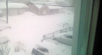
.png.b7aa6c7278ff88c43ee836a6529cd1cc.png)
February Medium/Long Range Thread
in Mid Atlantic
Posted
I’d say that was a very successful 12z suite. GFS and Icon became much more favorable. Euro and Ukie stayed very good. CMC was the only real downer, and I don’t think that’s worth stressing over.