

justinj
-
Posts
351 -
Joined
-
Last visited
Content Type
Profiles
Blogs
Forums
American Weather
Media Demo
Store
Gallery
Posts posted by justinj
-
-
Lost power at work I’m smithtown
-
Very very windy here in smithtown at work now. Drive in was a mess going through hauppague and smithtown. Trees down everywhere
-
Wow bad here in holbrook!
-
3 minutes ago, Cfa said:
Getting dark here now, I’m currently dragging in the houseplants, one of which already blew over in last night’s thunderstorm.
Also, am I the easternmost forum regular? I feel like I’m always the last one to see impacts with most storms.
Where are you located in Suffolk? I’m in holbrook
-
1 minute ago, SnowGoose69 said:
Tornado risk looks to be most central and eastern LI based on radar. Nassau should dry slot
Headed straight towards me
-
2 minutes ago, psv88 said:
I am not liking what i am seeing south of here. Very concerned
Me either doesn’t look good
-
Looks like jersey is getting the best of it
-
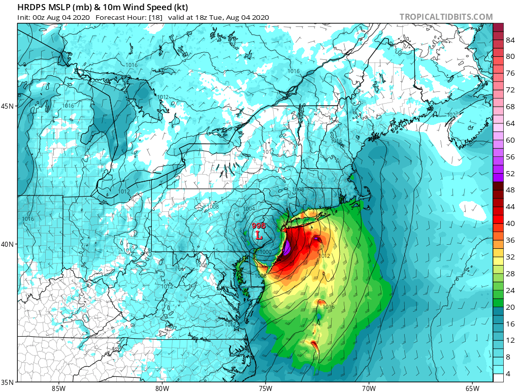
Moderate wind gusts here in Holbrook a couple miles east of Islip airport. Gusting to around 30 looks like jersey shore and southwest LI will get the best of the wind
-
11 minutes ago, LongBeachSurfFreak said:
It’s going to come in like a wall with the main feeder band. We should see consistent gusts in the 50s then. After that the question is can we surpass 70
We won’t.
-
 1
1
-
 4
4
-
-
2 minutes ago, purduewx80 said:
agreed. not even seeing that in NC obs now.
It’s overdone
-
1
-
-
5 minutes ago, Blizzard-on-GFS said:

Nearly all of the MESO models show an intense band of roughly 60 MPH sustained winds making its way up the barrier islands of NJ. It's hard to believe but almost every model has it. Gusts would be even higher. I know it's crazy but these winds would probably warrant a hurricane warning for these areas; I doubt the warnings will be hoisted but it will be interesting to see how bad it gets.
I can’t see anyone seeing sustained 60. I’ll believe it when I see it. I think you’ll see 50 sustained. I personally think the wind is overhyped. High winds will be very very isolated
-
1 minute ago, donsutherland1 said:
Some areas had wind gusts in excess of 50 mph. JFK recorded one such gust.
His location is in Commack and I’m working about two miles away from Commack and it was nothing impressive at all
-
1
-
-
What’s the likelihood of actually seeing 60-80mph gusts on the island? I’m gonna believe it when I see it I’m sure 40-50 will occur
-
7 minutes ago, psv88 said:
Lost power
From what a 30mph gust? Lol
-
5 minutes ago, LibertyBell said:
yeah a 3ft surge wouldn't be something we want to see.
is high tide around 8 PM tomorrow night on the south shore?
9ish
-
1
-
-
More and more concerned about major power outages on LI if we see the higher wind gusts
-
I’m in south central Suffolk hoping the higher winds and gusts stay on the beaches and over water. Really hope we dont lose power
-
1
-
-
Roads a mess in smithtown
-
Timing of rain tomorrow for Long Island? Hoping it will hold off until late afternoon
-
Can’t believe how strong Dorian is going to be when it hits the Nova Scotia area
-
What do the remnants of Dorian looks like for Thursday-Friday for the tri state area?
-
Beautiful day. Quite warm in the sun
-
I’m at work in Smithtown girlfriend says we have power in Holbrook. Looks like the worst went a bit further north of me
-
I’m in Holbrook just north of sunrise looks like I’m gonna get it good
Tropical connection NYC forum area Sun-Wed, 8/2-5/20- Tropical Storm Isaias
in New York City Metro
Posted