

Save the itchy algae!
-
Posts
149 -
Joined
-
Last visited
Content Type
Profiles
Blogs
Forums
American Weather
Media Demo
Store
Gallery
Posts posted by Save the itchy algae!
-
-
The latest gfs shows several opportunities for winter weather coming up, hopefully one of them is more than token flakes.
.-
 2
2
-
-
My senses tell me we aren’t in the right area for this one.
. -
The 00z GFS is beginning to sniff out something in that timeframe.
.-
2
-
-
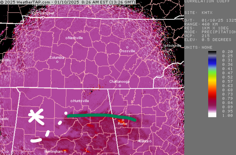
Very light snow in Farragut at the moment.
. -
I’m surprised to hear springs have gotten warmer. I feel they have gotten colder. Especially having colder Aprils. A cold March & April does not surprise me. It seems February has been warmer only to see winter come back in March & April with the dreaded cold rains.
Springs have gotten cooler in my 10 years here the last few, there’s no doubt. But it’s a small sample size.
. -
Not our region but my Dad in the Atlanta area ( Stone Mountain) is reporting 4” of snow with snow lightening up.
.-
2
-
-
Chattanooga is truly on the edge of glory or the edge of a cliff. Change to rain, or thundersnow?
If I play Lady Gaga's Edge of Glory maybe it'll stay all snow and we'll get thumped.The upper jet will produce good fronto-genetic forcing along withisentropic lift into the region. Good dendritic snow growth isnoted as well along with several hours of CSI for snow bandingespecially across southeast Tennessee, northern Plateau, westernhalf of the Tennessee valley and southwest Virginia.
Rain line on CC was moving north, and still is. At the same time it's dropping south where heavier snow is muscling in. Edge of Glory, baby!
Just talked to my dad in Atlanta metro and he has moderate snow falling.
.-
3
-
-
Decent snow shower in Farragut currently.
.-
6
-
-
Is this one over or is everyone focused on the slider?
. -
Might have to go buy that indoor propane heater I saw at Lowe's earlier today if this comes to fruition.
Got one of those for my son’s early season baseball games. Can’t wait to use it
.-
1
-
-
Trying to remember for sure, but I'm pretty positive last year the ICON locked into the January winter storm and it was the only model that didn't waiver or go off the rails at one time or another from 180 to storm day.
I’m sure that you’re right but I also remember the gfs sniffing it out at times really early.
.-
1
-
-
.
Sorry I don’t know how to edit my posts yet on Tapatalk (hate it) but I’m including the link to the discussion. It’s a fantastic read but it’s too long to copy
https://www.cpc.ncep.noaa.gov/products/predictions/threats/threats.php
.-
6
-
-
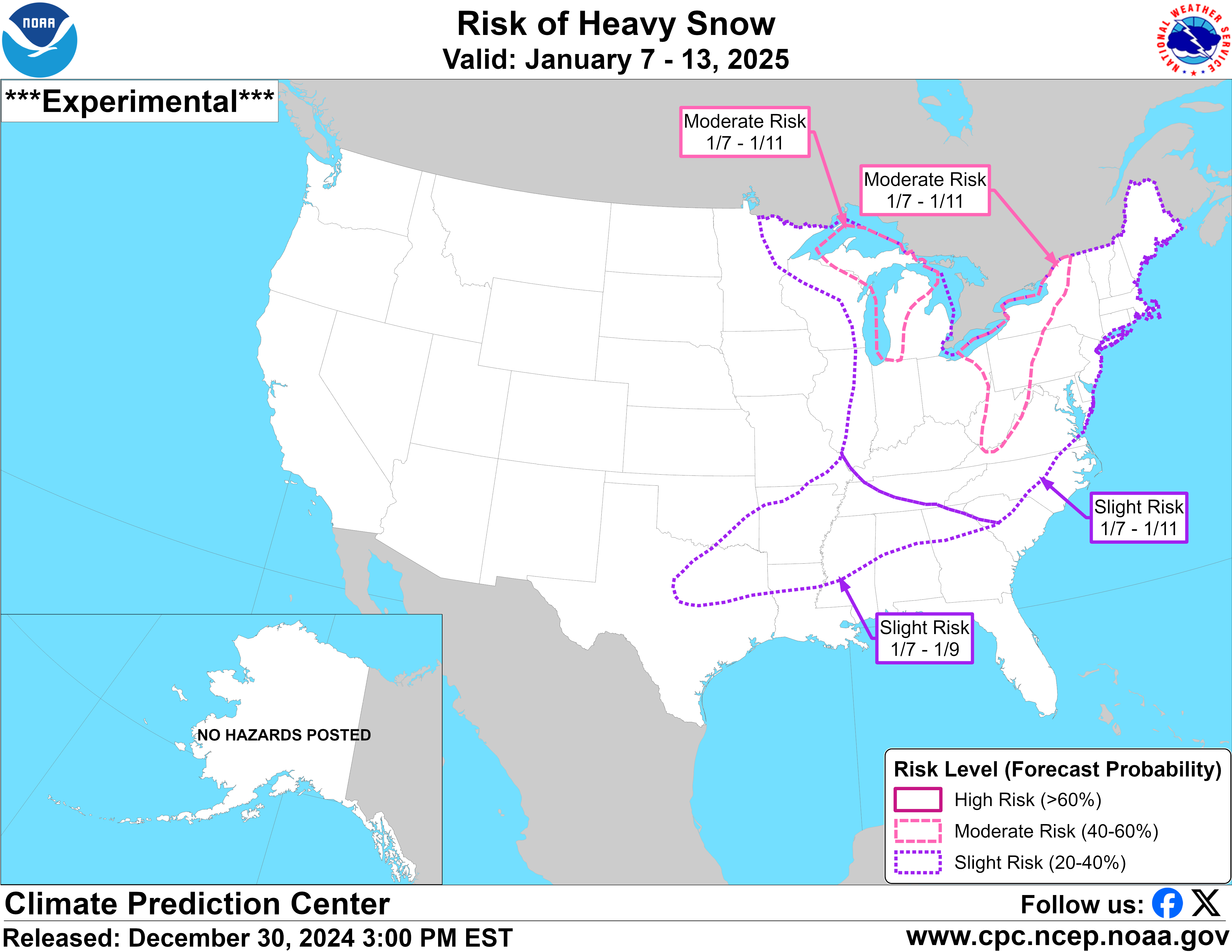
I am not where I can post images right now, but the CPC hazards map is a Christmas tree.
.
-
6
-
-
36 and rain leaving Farragut this am. Feels close to snow!
.-
4
-
-
2.5" total here. Most fell in that first wave of precip.
my totals the last 2 winters are 4.3 (23-24) and 4.0 (22-23).
How did you only get 4.3” last season? We got 9” alone from that one storm and Farragut is usually one of the lowest snow total areas.
. -
Glad to be out of my slumber, bring on December!
.-
3
-
-
I’m surprised no one has commented on the 00z gfs. That’s quite a storm signal around that 18th~ish time frame, keeps popping up!
.-
2
-
-
It looks like this is pretty much it then the storm is done, anyone else seeing something different?
. -
4C here in Huntsville/Madison. Roads have been treacherous all week since all our precip came down as sleet, but today the roads are kinda sorta passable (those are meteorological terms, right?).
Our precip is forecasted to be rain, with the cold arriving quickly enough freeze the wet streets-wéve got a lot of wet, mushy ice that would be fine except that everything is supposed to freeze.
I'm very interested to see to the forecasts/models handle the existing snowpack in TN.
precip is currently virga.
Sir this is America.
.-
2
-
 1
1
-
-
OHX Morning Discussion...
000FXUS64 KOHX 161218AFDOHXArea Forecast DiscussionNational Weather Service Nashville TN618 AM CST Tue Jan 16 2024...New AVIATION....SHORT TERM...(Today through Thursday)Issued at 231 AM CST Tue Jan 16 2024The mid state now has a legitimate snow pack and this will need tobe taken into account in terms of dealing with our upcoming tempfcst. Looks like 4-8 inches of snow depth is rather common placearea wide. For now though its a very cold morning with current tempsholding in the 10-15 degree range.Clouds are still in place but we will get some clearing by afternoonfrom nw to se. It`s not going to warm up much however as we have twothings working against it. For one, the snowpack will of course actto reflect much of the afternoon solar radiation that we finallystart to get. Secondly, strong thermal troughing will be buildingour way with those 850 mb temps dropping toward -15C by thisafternoon. So, will undercut the NBS numbers by a few degrees. Lookslike highs today will reach just the 14F to 19F range.Looks like a bone chilling cold night ahead. By Wednesday morningthe sfc high will reach MS with ridging extending northeastward.Clear skies and the snow pack will help send our temperatures downto close to zero for many locations. Following this, theWed afternoon temperatures will finally warm back up into the 20s.For the wind chill advisory, latest apparent t grids suggest thatthe advisory shall continue. It will therefore remain in effectuntil 9am Wednesday morning. Though winds will be on the lighterside, the temperatures themselves will be cold enough to producesome negative wind chill values. This is due to the 8-10 mph windsthat are expected at times.Moving on, another storm system will take shape near the Arklatexregion late Wednesday night. The sfc low will stay to our south andthere is some n-s inversion with the system. Hence, there will besome waa trying to kick in on Wednesday and into Wednesday night.However, when taking into account the expected wet bulbs at avariety of levels, the recovery looks a touch overdone by themodels. That said, for now, it appears that this next system will bemostly snow north and rain and snow south. We could also experiencesome IP activity across the south as well but for now will avoid theinclusion. The system right now does not appear to be all thatstrong but some light snow accumulations cannot be ruled out.Perhaps an inch or so of snow will be possible Thursday intoThursday night, mainly north and Plateau.&&.LONG TERM...(Thursday Night through next Tuesday) Issued at 231 AM CST TueJan 16 2024In the extended forecast, another arctic front will be on the heelsof the Thursday system. Lows by Friday morning will be back down tonear 20 for many areas with just a small warmup during the day.Adding to the chill will be some light snowfall that could continueinto the day. The rest of the extended looks dry but very cold. Lookfor single digits for lows into the weekend with moderating tempsand highs near 40F by Monday.&&.AVIATION...(12Z TAFS)Issued at 618 AM CST Tue Jan 16 2024Light snow showers should end SRB/CSV by 16/14Z-16/15z. InitialIFR/MVFR ceilings SRB/CSV will become exclusive MVFR after thru17/00Z. Initial VFR ceilings will continue to prevail CKV/BNA/MQYwith gradual ceiling degradation CKV to MQY 16/23Z-17/01Z.Errosion of ceilings at all terminals should occur no later than17/03Z as high pressure influences surface and aloft strengthenacross our area. Initial sfc sustained NW winds around 10ktsshould slowly back to S as 17/12Z approaches.&&.PRELIMINARY POINT TEMPS/POPS...Nashville 18 2 28 15 / 0 0 0 0Clarksville 16 4 28 15 / 0 0 0 0Crossville 15 -2 25 12 / 0 0 0 0Columbia 18 -1 27 13 / 0 0 0 0Cookeville 15 -2 24 13 / 0 0 0 0Jamestown 15 -2 25 12 / 0 0 0 0Lawrenceburg 17 -1 26 13 / 0 0 0 0Murfreesboro 17 -2 27 12 / 0 0 0 0Waverly 17 2 28 15 / 0 0 0 0&&.OHX WATCHES/WARNINGS/ADVISORIES...Wind Chill Advisory until 10 AM CST Wednesday for Bedford-Cannon-Cheatham-Clay-Coffee-Cumberland-Davidson-De Kalb-Dickson-Fentress-Giles-Grundy-Hickman-Houston-Humphreys-Jackson-Lawrence-Lewis-Macon-Marshall-Maury-Montgomery-Overton-Perry-Pickett-Putnam-Robertson-Rutherford-Smith-Stewart-Sumner-Trousdale-VanBuren-Warren-Wayne-White-Williamson-Wilson.&&$$SHORT TERM...21LONG TERM....21AVIATION.....JB Wright
It’s not just this post, but the AFD’s with all this coding or whatever is just unreadable. But it’s weird, when I quote it the text then becomes readable in my quote only.-
1
-
-
This will be a deceptive storm on record books.
Tys has I believe 3 inches as the official measurement and Tri a trace. But that won't be reflective of this storm for climate purposes.
How is that possible?
.-
 1
1
-
-
Just finished driving home (Farragut) from Florida. I am super tired lol.
Anyway, it was chilly all the way down. Around 60 at the beach, mid-upper 40’s near the fl/ga border, around 40 in Atlanta area, started seeing salt on roads around Lake Altoona area temp 38, temp was 34 around tunnel road in far n Georgia and chatty, ooltewah was where I saw light dust on some cars in car lots temp 34, didn’t see first flakes until around Cleveland and some brine, significant difference around sweetwater/philadelphia temp 30 and most everything covered except interstate, made it to house where there’s about an inch of snow-maybe a little less and everything covered, temp 27. Going to read the updated nws forecast then going to sleep
.-
1
-
-
It has almost completely stoped hear in Knoxville. We have about a half inch. Hopefully something changes or we are going to way underperform.
This is bonus snow right now, not the actual event.
. -
Skin that smoke wagon! Go for it!
My last name is Murphy. Nobody wants me starting it. I have laws named after my luck.
.-
1
-
3
-
Spring 2025 Med/Long Range Discussion
in Tennessee Valley
Posted
Hope some of that makes it over to Oneida
.