Sw NC weather
-
Posts
523 -
Joined
-
Last visited
Content Type
Profiles
Blogs
Forums
American Weather
Media Demo
Store
Gallery
Posts posted by Sw NC weather
-
-
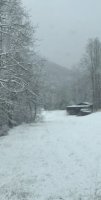
Had sleet all night that killed our totals still have about 4-5” on the ground and 6” on elevated surface hopefully we can squeeze 2-3 inches on the backside tonight
-
Wow it’s absolutely pounding right now I seen channel 4 moved us into the 8-12 + u guys around cashiers to Hendersonville that already have a lot are gonna get a lot more.
-
 1
1
-
-
Congrats to everyone to my east I’ve probably got 1/2 inch on grass and cars and rates are starting to pick back up and sitting at 31.1 which is 4-5 degrees colder then the lastest hrrr started. Do u guys think that might help there be more snow out my way?
-
Temp has really fell in the last 30 minutes to 31.6 with moderate snow hopefully we can stay snow through the night
-
.1 inch of ice on everything and big flakes of snow trying to start accumulating
-
7 minutes ago, franklin NCwx said:
Did you go up cowee bald?
Yea up to the Leatherman gap it was coming down good with abt 3 inches
-
6 minutes ago, franklin NCwx said:
Rain snow mix here now
That’s what we have in cowee now, rode up the mnt and about 4000 feet up there was a good 2-3 inches a hour ago
-
Just now, franklin NCwx said:
But we will be fighting the warm nose for most of the event.
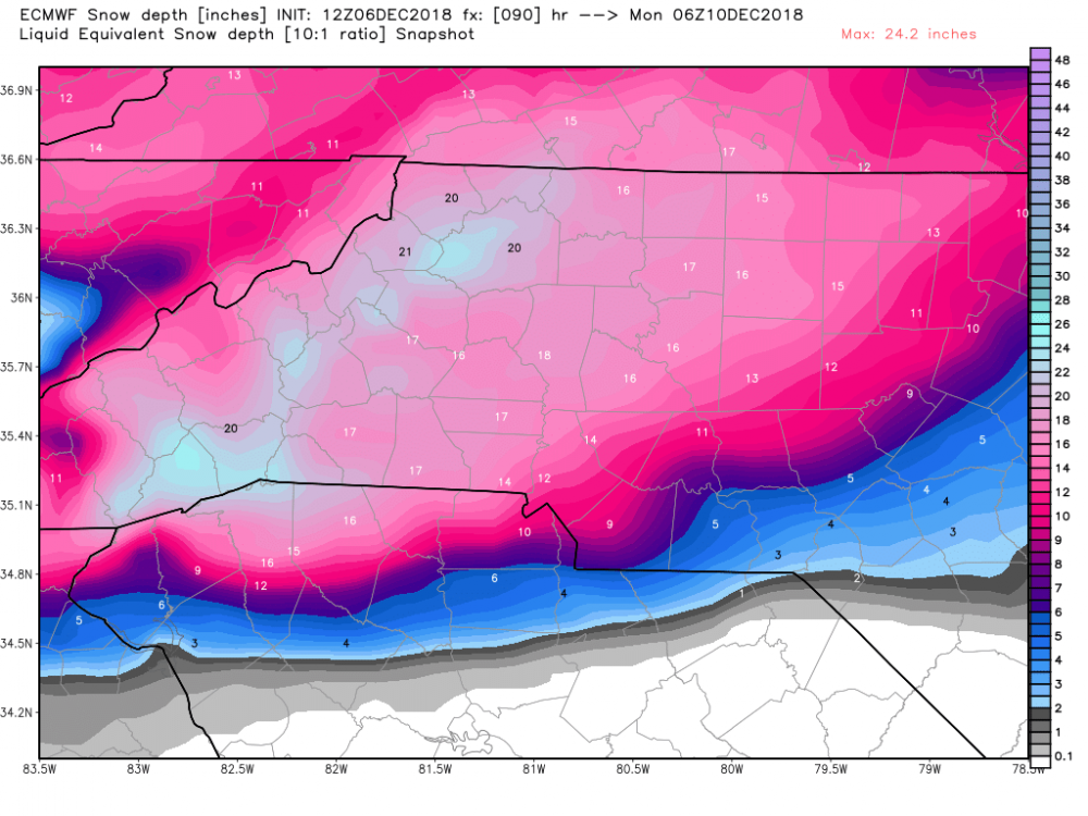
We will be over 100 inches of rain after this storm.
I’m starting to think with the ensembles and the trends on the nam I feel like we can score a solid 8-12
-
1
-
-
The GFS and the Canadian both came in with bigger totals from the balsam range west
-
19 minutes ago, BretWheatley said:
Bloop.
Is it still snowing at hr 90
-
1
-
-
6 minutes ago, BretWheatley said:
Mean for KAVL jumped from 16.58 to 20.01: http://www.emc.ncep.noaa.gov/gc_wmb/tdorian/gefs/EMCGEFSplumes.html
Can you post it
-
The 12 nam at 84 hr is quite a bit colder then the 6z gfs at hr 90
-
2
-
-
Just now, ozmaea said:
Euro starts at 1 right
Sent from my SM-N950U using Tapatalk
No started at 12:45
-
Hard not to get excited I just saw the 6z GEFS and it had a mean of 5-10 inches through the mountains. that’s surprising still being 5-6 days out
-
1
-
-
Decent flurries at my house Down in the valley 2500 feet went deer hunting up on the mnt abt 4000 feet and a solid dusting when I left around 5:45
-
2
-
-
4 hours ago, Rankin5150 said:
How is the trends looking for areas outside of the Foothills/Mountains? Thanks in advance for any input
Temps are close even in the mountains as of now a non-event outside of the mountains
-
 1
1
-
-
Models overnight are definitely trending favorable for next Friday. I think us mnt folk might can score a solid 2-4 event
-
Starting to see a few flurries with a temp of 34.4
-
I know it’s the 18z GFS... but wow it close to something big for us mnt folks around the 14th
-
3
-
-
Hello fall ! Got down to 41 this morning
-
It’s Up to 50 mph
-
Nice day today a little rain this morning 0.21 then overcast the rest of the day with a high of 69.4
-
Stalls out over nw NC on this run
-
Gfs is constant with a pattern change starting around the September 20th
Mid to Long Term Discussion 2018
in Southeastern States
Posted