

Tar Heel Snow
-
Posts
345 -
Joined
-
Last visited
Content Type
Profiles
Blogs
Forums
American Weather
Media Demo
Store
Gallery
Posts posted by Tar Heel Snow
-
-
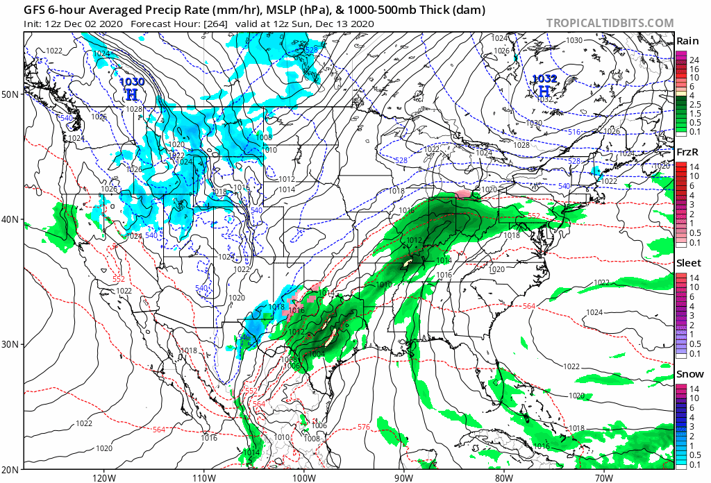
Wasn't sure where to post this (and wanted to hear from folks who are more well-versed in weather in our area), but what's the reason that a system like the one starting over Texas at the beginning of this gif pushes off northeast rather than "digging down" over the SE as I've heard on this forum over the years? What's steering this? the high in Quebec? What would it take to make something like this go favorably for us?
-
 1
1
-
-
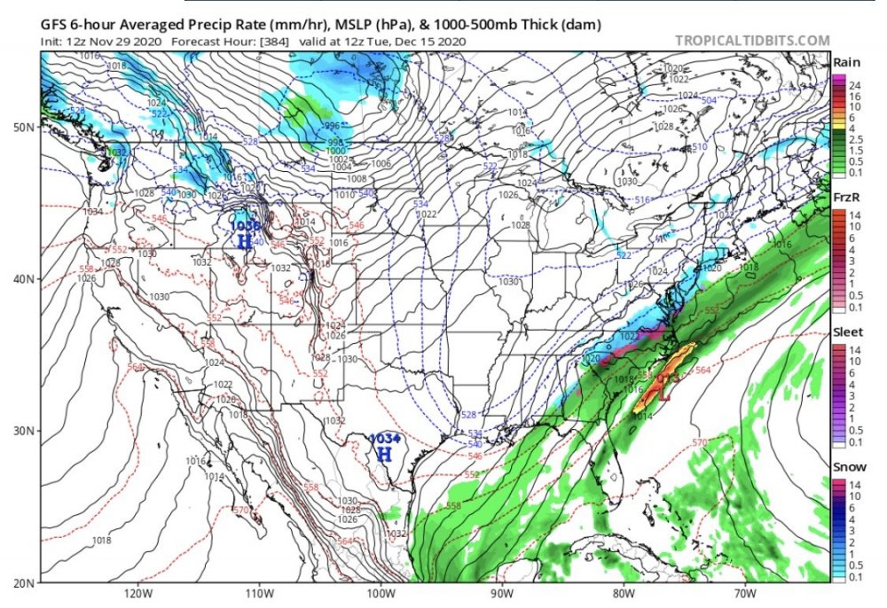
Even at 384 hrs, the heartbreak gradient is still there!
-
4 minutes ago, Tater Tot said:
My favorite part was the debris ball in the eye thing. Now that was creative!
Oh to be a bird flying in the middle of a hurricane!
-
I'm sorry but this board is my favorite thing. You've got people arguing about small changes to intensity, you've got people arguing about radar, you've got people who are trying to get people to stop arguing, you've got people just making jokes, you've got awesome real analysis, you've got great chances to learn, and you've got people posting about arguments that happened 15 minutes ago because they just don't read what's happened since the last time the page refreshed. Y'all are great. Carry on, and stay safe.
-
1
-
 3
3
-
-
Reading anything about the sun and kooky weather stuff just gives me flashbacks to sun angle posts for winter storms in the SE forum

-
1
-
-
9 hours ago, yoda said:
At least one specific poster isn't here posting about Sandy
At least Rutherford traded Jack Johnso—oh wait. Kappy being back is nice though
-
Finally starting to stick to some mulch, cars, and roofs.
-
7 minutes ago, wake4est said:
It’s because the ground is warm.
That too yeah, shame, wasting some great snow rn! Pretty to look at though

-
Been coming down awhile and none of the snow is sticking, I imagine that’s because it’s 36°?
-
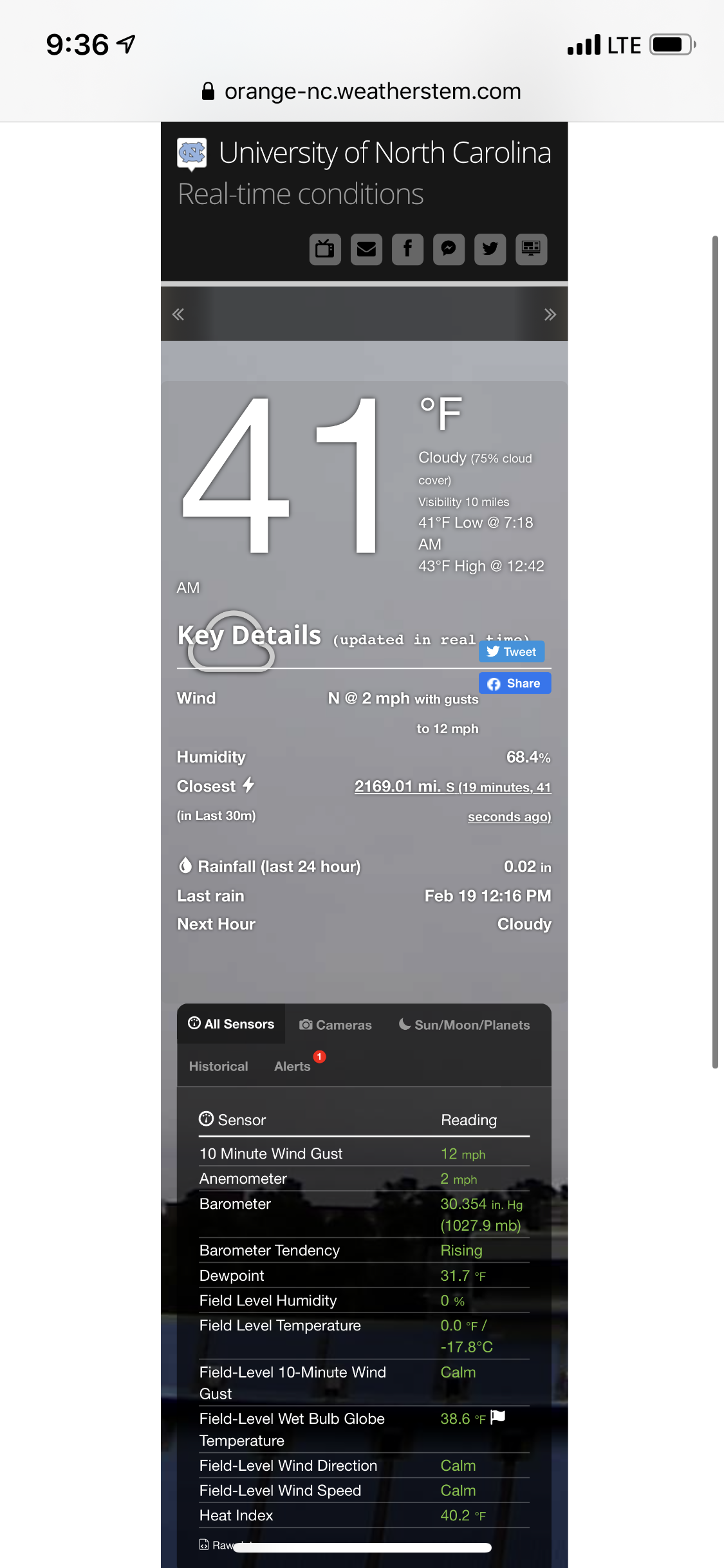
Has been snowing harder here at UNC for the past 10 minutes or so, nothing sticking yet.
Visibility down for sure.
-
Through moderate size flakes I just saw someone’s car get towed. That’s...just cruel
-
Some extremely light rain mixing in here now, just enough to maybe wash away brine lol
-
Light snow in Chapel Hill, no mix
-
1 minute ago, GoAPPS said:
What app is that?
RadarScope
-
Still waiting for precip on campus here in Chapel Hill
-
21 minutes ago, mackerel_sky said:
That 12z NAM!! Yeah, baby, yeah!!! Non shagadellic! No snow in the upstate, is this the same model we had giving RAH 12” the other day!??
Dewooints ain’t gonna matter if you don’t get the rates, GSO-RAH , 1” at best
 but also
-
-
7 minutes ago, NorthHillsWx said:
We got down to 38 and are already up to 45. I'm not going to sugarcoat it, that's not a good place to be with precip set to move in in the next 3 hours. Good news is DP's have FINALLY tanked into the 20's. That was a painful fall but they are crashing with the NE wind. I'm not model watching anymore they will bounce around with their clown maps until the very end but temp wise, we are running a couple degrees above where the globals (and NAM) had us yesterday and are in line with the HRRR. I did not think we'd exceed 41-42 today. Radar looks very NAM-like which is good but I am worried about folks west of the influence of the coastal. West of the Triangle may have more precip issues than we thought as even the NAM has trended more to the globals on that western cutoff. Radar watching will be the only way to confirm that. I would hit the panic button if precip is not gaining more of a WSW to ENE movement and pushing up into the Triad area by lunchtime. I like my forecast from yesterday and am sticking to it. I think RDU is a lock for 2-3 in and the coastal plain looks to be good for 4+ in. If we had better temps (as always) I think Max snow potential would be doubled at least but I know we will waste at least 0.25" here on wetbulbing and white rain. CLT-Upstate, I still don't think anyone outside of elevation will see any accumulation. Just not those areas' storm, unfortunately.
At this rate, RDU definitely means more Raleigh than Durham/Chapel Hill. Just need that precip to be a smidge west for mby. It’ll be close, especially living closer to Carrboro.
-
-
At least 5 inches from Chatham and Alamance county east, hard to complain about that.
-
1
-
-
Before we get into too much now casting and we get into the observation part of this storm, I want to thank everyone for making this a truly fun and educational track.
After a really tough winter, this storm and its thread have reminded me why I came into this community in the first place. It’s always great to go through the ups and downs with you all, even more so after starting my first thread!
To the mets and experts, thank you for being clear, patient, and generous with your knowledge. It’s intentional, thoughtful, and informative.
To the mods, thanks for keeping this board a positive place for all to enjoy and learn.
To the Macks of the world (you all know who you are), thanks for keeping things light and fun!
And to everyone, may your snow totals resemble clown maps and may the warm noses stay to your south.
As always, there will be lessons to learn when it’s all over, but wishing everyone the best! You all make this community special, and I’m grateful for it.
(Mods, I apologize, I know this should be in banter!)
-
20
-
 4
4
-
 2
2
-
-
3 minutes ago, BullCityWx said:
It looks like we at least held the line this run if not pushed it a few dozen miles south this run. Hope it continues!
-
1
-
1
-
 1
1
-
-
12 minutes ago, BullCityWx said:
3K has basically the same map with a little less snow owing to less QPF(about .15 less). There is less snow down to Charlotte and in the foothills.
Also gives south Orange County a little bit of a burst, suppose it depends on where the bands set up. I could use classes getting cancelled tomorrow
-
Start of the lower-res NAM is looking waaaaarm bc of course

Winter 2020-2021 Outlook
in Southeastern States
Posted
That makes sense, thanks! I've been trying to wean myself off of the whole "just look at the precip type maps" thing especially that far out because they tell you so little. Especially as I try to learn more about what you can learn from the other maps. But as for my specific question, that's definitely really helpful. And good overall guidance too!