

OrdIowPitMsp
-
Posts
1,911 -
Joined
-
Last visited
Content Type
Profiles
Blogs
Forums
American Weather
Media Demo
Store
Gallery
Posts posted by OrdIowPitMsp
-
-
Snow winding down with a little over 5” here. Depth back over 20” and now have surpassed 60” on the season.
-
 1
1
-
-
March has come in like a lion, 2.5” and counting so far today. Looks like a few more hours to go until the snow ends. Glad I got off work early the roads are a mess.
-
Ended up with an overachieving and very fluffy 2.6” here.
-
1F with some light snow and 1-2” in the forecast today, more Friday. Best February ever!
-
1
-
-
Bring it on. I’m not ready for spring until May 1st. Last year was perfect.
-
1
-
-
February 2019 total now up to 35.7” with the latest snow.
-
1
-
-
3.5" at MSP, 24 hour total of 4.5" if you include the front end bump. Puts me up to 54" on the season.
-
1
-
-
Skiing down in Welch Village 10 miles SW of Red Wing MN, heavy snow when we left with the wind quickly picking up, and stacking fast. 30 miles north in Minneapolis just barely some flurries atm. Cutoff is going to be crazy sharp.
-
Burst of mod/heavy snow now with the initial wave which should give us 1-2”. Brutal cutoff across the metro, SE locations could push 6-8”+ by Sunday morning with less then half that NW. Winds will get interesting later today and tomorrow, travel in rural areas could become nearly impossible.
-
8.9” officially at MSP which is our largest snow of the season. Winter total up to 49.3”
-
1
-
-
I’m going to estimate 8” out in Courtland Minnesota between Mankato and New Ulm. Still snowing hard.
-
1 hour ago, Minnesota_storms said:
I'm near Mankato as well. Radar has a train of heavy snow going over me over and over. Sun is coming up and it's coming down hard. Pictures soon.
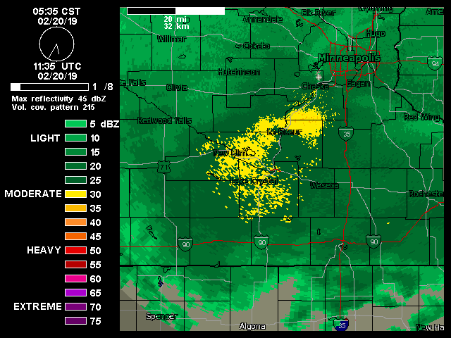
Nice! It’s absolutely pounding here. I’m working off Nicollet County Highway 12 if you know where that is.
-
Absolute rippage in Mankato, definitely looks like work sent me to the bullseye on this one. Rough estimate of around 4-5” in the parking lot.
-
Going to be working outside drilling soil borings on a lake all day tomorrow near Mankato. Should be fun with 2”/hr rates. 7-9” seems likely here at this point.
-
1 hour ago, Minnesota_storms said:
Now they have really upped the totals. At least it won't be very windy this storm. Winter Storm Warnings are now being issued.
Yeah this is really trending in our direction quickly, definitely was surprised to see WSW hoisted when I woke up this morning. Unfortunately I’ll be out of town in Courtland MN for work through Thursday.
-
Trending nicely for a solid 3-5" here, maybe more as we've tended to over achieve as of late with some help from high ratios. Backyard snowpack has compacted down to around a foot, will be a nice refresh.
3.9" for MSP to tie its snowiest February. I'll take the over.
-
0.3” with the cold front this afternoon. Puts us up to 40” on the season.
-
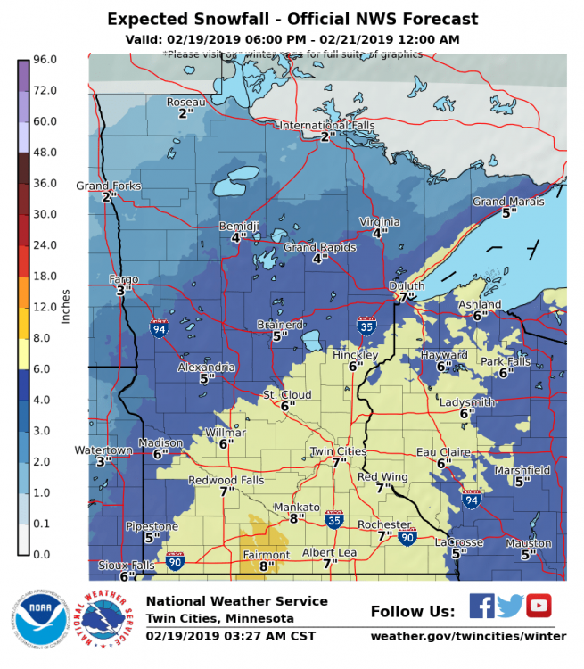
MSP was at 5.3” at noon. Hasn’t stopped snowing yet so it looks like we’ll be making a run at 6” or more. Models did not have a good handle on this system, after showing 8”+ totals for days they backed off significantly and it was looking like a mundane 2-4” February snow record is in serious jeopardy
-
4” here with some light snow pushing through this morning. Minneapolis has now received over 20” of snow since Feb 1st. Running out of places to put it all. Estimate 15” OTG, and monthly snowfall record is within reach. My how the tables have turned
-
8-12” becomes 6-8” becomes 4-6” becomes 2-4”. Big time model shift east inside 36hrs looks to make this more of a nuisance event in the Twin Cities.
-
 1
1
-
-
6” with the system that came through today. Nice overachieving high ratio snow.
-
Starting to get tough not to be excited about the prospects of a big hit imby.
-
-10F air temperature windchill of -31F. Might pull off another negative high today.
-
4.1" Tuesday evening
6.8" last night and today.
Depth is ~11" IMBY, easily the deepest of the season. Had to feed my powder fever so went skiing this evening and saw lots of snowmobiles out as well. Up to this point we really hadn't had much of a natural base in this part of the state. The 6pm observation of 5.7" at MSP set the daily record for snowfall. I imagine the midnight observation will finish around 6"
Definitely the best stretch of winter we've had this season. If you go back two weeks there is another 5" snowfall and a historic arctic blast to boot.
-
2
-
March 2019 Discussion
in Lakes/Ohio Valley
Posted
5.6” official total at the airport. Since January 26th which was 35 days ago MSP has received 50” of snow.