

OrdIowPitMsp
-
Posts
1,911 -
Joined
-
Last visited
Content Type
Profiles
Blogs
Forums
American Weather
Media Demo
Store
Gallery
Posts posted by OrdIowPitMsp
-
-
Well things have escalated quickly here. 2” down and easily adding an inch an hour. Good thing I left work early, the roads are snow covered....so much for the April sun.
-
Snow has started in Minneapolis, definitely going to start sticking soon. No mixing issues yet.
-
Wagons north. Looks like we’ll get more of a mixed bag of precip here then purely snow. As long as MSP records 2.7” and we get to 70” on the season I’ll be happy.
-
NWS Chanhassen has issued a Winter Storm Watch for the twin cities. Saying there could be some isolated 20” totals but officially forecasting 7-15” for the area. Could see winds sustained over 30mph snow its gusts over 50mph.

-
GFS not backing down at all, in fact now showing more widespread 30” totals in southern MN.

-
Repeat of April 2018?

-
Torched up to 64 yesterday. Felt incredible and melted off most of the remaining snow in the yard. Still lots of piles and some snowcover in the woods and north facing slopes.
-
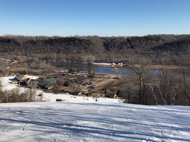
I guess this could go in a few different threads.... here’s some photos of the Cannon River flooding from Welch Village Ski Area on 3/23. This is the highest I’ve seen the river in the 4 years I’ve been skiing here.

-
 1
1
-
-
What has been described as a “perfect melt” produced the first dirt patches in the yard yesterday. All last week we had sunny days with highs in the mid 40s and lows in the upper 20s which provided a gradual melt. Lots of ponding of water and flooded rivers but worst case scenario has been avoided here.
-
Spring thaw well underway here. Should have our first 50 degree high since autumn later this week. 4-5” of snow left otg and bare patches starting to show up in usual spots. Unless we have a massive warm up there will be large piles well into April this year.
-
0.48” of rain today. Temperature has risen to 41 under a dense snow melt fog.
Snow depth down to 9” lots of ponding on the roadways in typical spots but nothing very disruptive.
-
4.7” official total here.
-
Got a 2.5” paste job so far with some light snow and drizzle. Don’t see how we get much past 4” let alone 6” for warning criteria, so going to be a bust here. Absolutely beautiful with snow coating every surface.
-
Big fat flakes and some pingers falling now. Already have a dusting.
-
2 hours ago, cyclone77 said:
35 with heavy rain. Utterly miserable. Lots of standing water with the frozen ground.
Pretty much a carbon copy up here. Losing a lot of precip to liquid and the roads are full of deep ponding water. Going to be a major bust here unless we change over soon.
-
Going to be a nowcast for mby. 3km NAM wants to keep the warm nose overhead and cuts down significantly on totals with mixed precip for a few hours. 12z HRRR wants to change things all over to heavy snow after a brief mix of precip to start things off. Anybody know if either model has a warm/cold bias or doesn’t handle mixing very well?
NWS seems to think the warm air issues will be just to my south and still expecting 6-8” for this area.
-
Winter Storm Warning hoisted as expected here. Gonna be a nail biter regarding precip type at the onset for the metro. 12Z 3K NAM wants to bring the warm nose up this way which could cut into totals and make the snow even heavier and more water loaded.
I Wonder if our snow depth will actually decrease if we get 8” of 7-1 snow. How much could it compact things?
-
Well looks like I’ll be shoveling this weekend.

In all seriousness though really glad my home was recently built (2010) with modern standards and codes. My neighborhood is mostly homes from 1910-1930 and the ice dam issue is becoming extreme. Another heavy wet snow could cause structural issues for some people.

-
8 hours ago, Minnesota_storms said:
Definitely like the Euro. Same path as the last run but is colder farther south. I kinda want snow but this and the system after will make us have 8'' of water in the snow. Hell of a snowmelt would happen.
Spring flood threat is going to be extreme around here. I fully expect soggy ground well into June....looking likely we will stay all or mostly frozen precip for this one.
-
1
-
-
GFS taking a step southeast towards the Euro and throwing down 12- 13” imby.

-
1
-
-
It’s GFS v Euro for the twin cities metro at this point. Really don’t want to see any liquid precip on top of all this snowpack. We need a slow melt. Going to be a fun storm to track this week.
-
1
-
-
-
-12F for the morning low. Record cold high of 6F in serious jeopardy. Sun is out in force and I can hear birds chirping as we sit at -10.
-
1
-
-
3 hours ago, Cary67 said:
From what I can recall you guys were due for a good year
I think portions of Iowa were more due but outside of last March/April it had been a few seasons of well below average snowfall.


April 10-12 Winter Storm
in Lakes/Ohio Valley
Posted
4.2" from the first wave. Lull now, should be rip city again by morning.
71.5" season total.