

OrdIowPitMsp
-
Posts
1,926 -
Joined
-
Last visited
Content Type
Profiles
Blogs
Forums
American Weather
Media Demo
Store
Gallery
Posts posted by OrdIowPitMsp
-
-
Maybe it’s legit
-
 5
5
-
-
-
44 minutes ago, mnchaserguy said:
There are some 16-19” reports starting to pop up in the central and south metro. I’m not sure I completely buy it but I guess the larger bands did favor the south metro more than the north. Maybe not a complete bust for everyone.
.Was about to post this. I don’t buy that 19” report but the 15-17” seems plausible given that area saw good banding from both waves. It’s still snowing fat dendrites here and I bet we have 13-14”
-
1
-
-
Time to focus on next week.

-
1
-
 1
1
-
 1
1
-
-
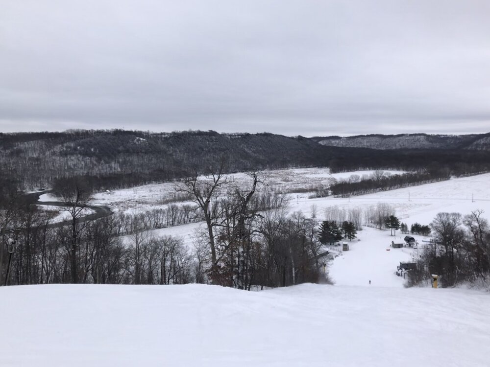
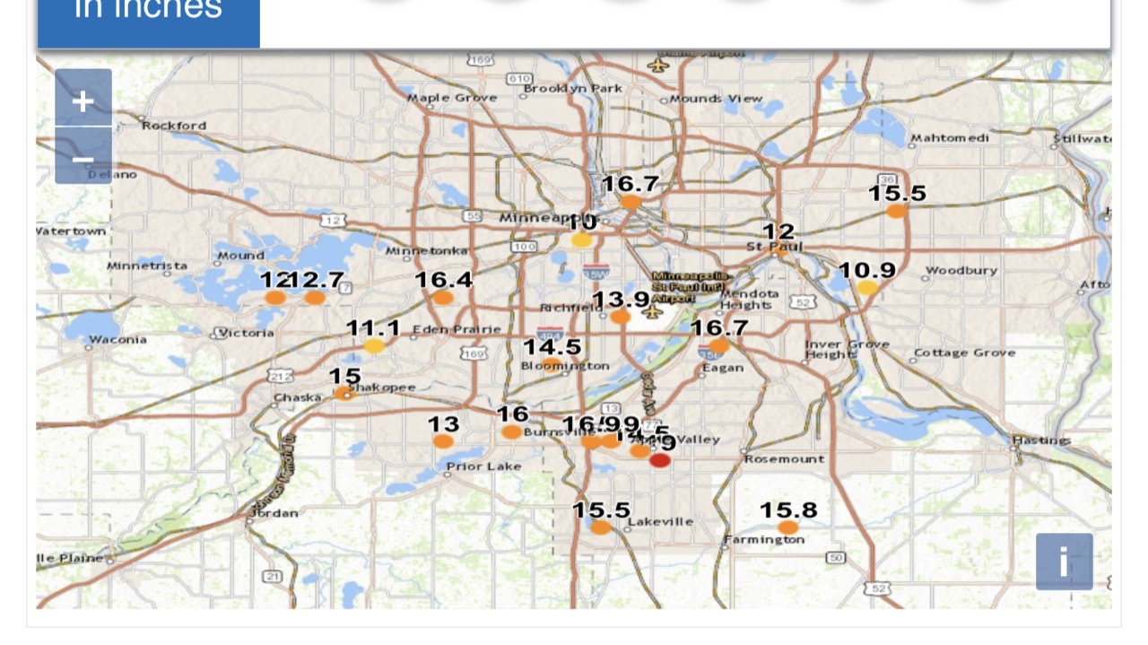
Now a 16” report in the SW suburb of Savage along with 15.5” in the southern suburb of Lakeville. Record February storm at MSP is 13.1” so that might be reachable depending on the noon obs. My ski area decided to leave all blues and blacks ungroomed overnight. Heading there for the noon open.
-
5
-
-
Airport was at 10.1” at 6am, NWS office 12.5”. I can say with confidence we’ve added at least 1.5” since then and it’s still snowing at a decent clip.
-
1
-
-
Looks like a 14.5” report was just filed a mile south of me.
-
2
-
-
There’s a few 12”+ CoCoRaHS reports coming in including a 15.5” in the eastern suburb of Woodbury.
-
1
-
-
8 minutes ago, mnchaserguy said:
Unless I’m measuring completely wrong, I’m at 10” for the entire event. If it actually snows all the way until noon I might hit a foot. No matter what, this will not end up even being a top 20 event for me, let alone top 5 like it looked like a few days ago.
.I’m still waiting to see the 6am obs from the airport, but I’m measuring 10-11” imby as well. At least it made shoveling easier.
-
1
-
-
The models really had no idea on the evolution of this system. I wonder if it came down to multiple shortwaves rotating through instead of one solid deformation band of snow, which caused the 50% over modeling of precipitation. It’s ripping now but I’m guessing the final storm total will be between 10-12” at the airport if they can get an accurate measurement in this wind.
-
1
-
-
Hope nobody here is without power for long. I’d take 34 and rain all day over a crippling ice storm.
-
 3
3
-
-
HRRR still putting down 0.60-0.70” of precipitation here before everything wraps up. That should translate to another 9” or so for a storm total of ~14-15” we’ll see how things shake out.
-
Storm total of 5.5” as of 6pm. That amounts to 1.4” from round 2. The NWS office was up to 6.5”
-
38 minutes ago, Hoosier said:
One of the ugliest wx days I can remember in a while. Stuck at 34-35 degrees all afternoon with mod-hvy rain. I'd take heavy snow in April over this any day. Today is just nasty with no redeeming value since it's too warm for ice.
We had that last week, 0.87” of rain and never got warmer then 37. Just the worst.
-
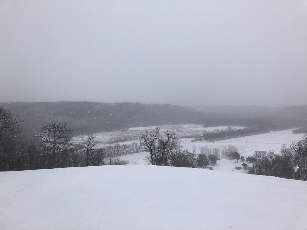
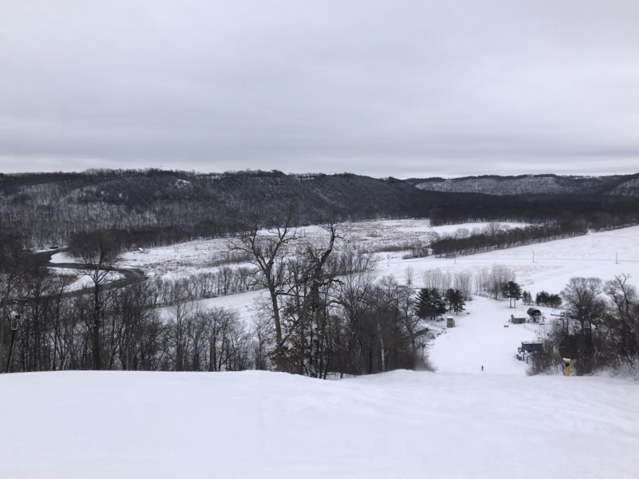
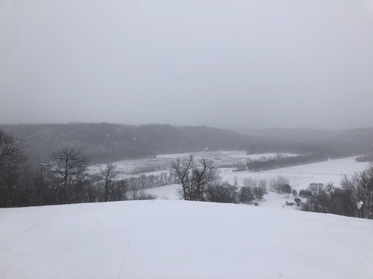
Before and after the main show started earlier this afternoon. Wish I could have stayed on the slopes longer, but I don’t want to chance it with the roads going downhill.
-
7
-
-
31 minutes ago, mnchaserguy said:
I wouldn’t be surprised if we don’t hit double digit totals for the entire storm. Snow having a really hard time getting going on the north side.
.Closing in on an inch imby from the main event. It’s coming down pretty good right now. What part of town are you in? I think 8-10” additional is probably what my side of town will see.
-
Good powder day at Welch Village ski area. Round 2 is on our doorstep.
-
Dropped the kid off at my in-laws. I’m going skiing, my local area was in that sweet spot last night and picked up close to 6”
-
5
-
-
13 minutes ago, mnchaserguy said:
Sun is out and I see blue sky here in the north metro lol
.Lol here too, a few blocks east of Lake Nokomis. Wasn’t expecting that, models still spitting out a solid foot here later today.
-
1
-
-
The 4.1” at the airport came from 0.33” liquid equivalent for a ratio of 12:1 which is lower then guidance. There’s a nice band still impacting Red Wing MN and areas just south of the metro.
-
6 minutes ago, mnchaserguy said:
3.5-4” here so far. Definitely low compared to the 6-8” forecast by MPX. Looks like a foot tonight into tomorrow is a solid better. Probably unlikely we hit 18” at this point. Big storm but significantly lower than what was shown by the models for several days.
.4.1” at the airport as of 6am. Definitely the lower side of guidance but they were calling for 4-8” in this first wave, so not a bust. Really strong banding overnight in the south metro. Shame models are showing a substantial drying trend but we should have know those crazy totals from a couple days ago were unrealistic. I believe the record February snowfall at MSP is only in the 13-14” range so the monthly record is still very much in play.
-
1
-
-
Eyeballing around 4” here. Lower end of guidance, but still within guidance nonetheless. People will call this a bust because we hit the lower end instead of the upper end. (Same as it ever was) The southern suburbs are doing well. There’s been a band stalled out just south of the Minnesota River for a few hours and I expect numerous 6”+ reports down there. Of course the official obs site at the airport is a few miles north of that…
-
1.1” accumulation as of 6pm. Looks like another 2-4” overnight before the main show tomorrow.
-
2
-
-
22 minutes ago, Malacka11 said:
I'd genuinely rather miss out altogether than have a mega dog trend to a big dog. To be that excited for something labeled as potentially historic for days only for it to trend downwards would be far worse than just another miss in an already shit winter.
I disagree, while it sucks seeing 12-15” instead of 18-22” I want us to crack the top 10 for longest continuous snowcover of 1” or more. #10 is 107 days and we are at 84 days today. Plus still have a shot at the all time seasonal snowfall record. If I was chasing futility maybe I’d have a different outlook.

February 21-23 Major Winter Storm
in Lakes/Ohio Valley
Posted
13.1” at MSP still ripping. 0.7” away from monthly single storm record.