

OrdIowPitMsp
-
Posts
2,417 -
Joined
-
Last visited
Content Type
Profiles
Blogs
Forums
American Weather
Media Demo
Store
Gallery
Posts posted by OrdIowPitMsp
-
-
Smoke quickly exiting the area with a SW flow. AQI down from 185 to 101
-
DP in the 40s but can’t go outside because AQI in the 180s.
-
Dews have mercifully dropped to the 58-60 range, after hanging around 70-72 the past two days.
-
 1
1
-
-
Steamy Independence Day in the Twin Cities. 88/70 at 11am. Water activities abound.
-
90 yesterday, 90 again today so far. Kids love the heat.
-
June ended up 0.5F above average in Minneapolis.
Pretty up and down month. 3 days above 90 with a monthly high of 96, but what stands out to me is the high of 57 on the 13th.
-
1
-
-
High of 85 today. Fell well short of the forecasted 90.
-
High of 66 yesterday with 0.76” of rain. Warming trend begins today.
-
32 minutes ago, jlauderdal said:
Rain has arrived in Eau Claire, its cloudy and 67, a few days ago it was 97.
We’ve been stuck at 63 all day here. Glad to be north of the front. Two days in the 90s was enough for me.
Our two day rain total will probably be somewhere around 3” once all is said and done in Minneapolis.
-
Monsoonal rain for the past hour+ here.
-
2
-
-
High of 72 with 1.68” of rainfall.
Not a single rumble of thunder up here, much different atmosphere in southern Minnesota today.
-
Over an inch of rain today so far. Eating away at our year to date deficit
-
10 hours ago, TheClimateChanger said:
Find me a single place that was actually 20 to 30 degrees below normal in the U.S. and then I'll believe that nonsense. What a joke
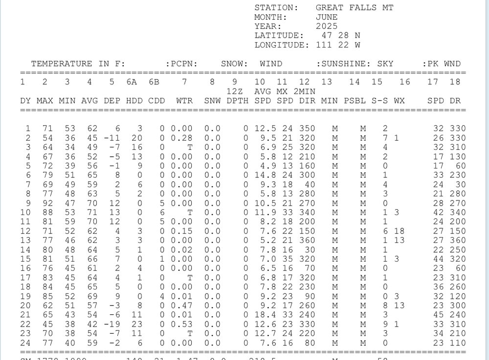
Didn’t look very hard, best I could find was Great Falls Montana with a daily departure of -19F on the 22nd.
-
2
-
-
Ready to get soaked at work. Geotechnical report on the Eagan high school athletic fields due Friday and I’ve got soil to look at. Bring on the rain.
-
Dew point has fallen to the upper 40s here. Oh what a feeling
-
2
-
-
79/66 currently with summertime cumulus. Big difference from this time yesterday when we were 91/74.
-
It’s a kiddie pool and splash pad kind of day. These are the good old days.

-
6
-
-
2 minutes ago, TheClimateChanger said:
Looks like the low so far has been 82F at Minneapolis (MSP), which is a daily record high minimum but 1F shy of the all-time monthly record in the threaded history. I do feel like there were periods in some of these recent years where MSP (and many of the larger airports) would be several degrees above surrounding observations. But they've been running much more in line with other observations, so no 84F or 85F in the cards today. Seems like they eliminated a lot of that so-called "urban heat island" effect. Don't expect these airports to pop a 100F in this heat wave when every other observation is 95-99F. It's going to need to be near 100F areawide (like 98-101F) to see a 100F observation. They've got these ASOS readings finetuned to a harder mode now. Either way, still setting a lot of records out there.

When we were still at 90 at midnight I thought there was a chance of breaking some records. Madison Minnesota is usually the warmest city in the Twin Cities WFO. Low of 86 there.
-
96 today. Forecast was 98 so I guess a bust low. Still 91 at 9:30pm
Both MSP and STC hit record high temperatures on Saturday, June
21, breaking the previous records of 95 set in 1910. The exact
values for each are still being verified, but they reached at
least 96. Record high temperatures are possible again on Sunday
with hot/humid air in place and the warm front remaining to the
north of our coverage area.

*** Record Highs Sun June 22 ***
Location | Forecast | Record
------------------------------
   MSP   |    97    | 98 (1911)
   STC   |    95    | 98 (1911)
   EAU   |    95    | 99 (1995)
-
From the NWS
The forecast low of 83 at MSP would be the second warmest low on
record, and 3 degrees short of the all-time record of 86 from
the Dust Bowl era.
-
 1
1
-
-
-
Bemidji Minnesota gusted to 106mph last night. Have to imagine there is extensive tree damage up there.
-
1
-
 1
1
-
-
24 minutes ago, TheClimateChanger said:
There are probably more. Those are just the sites I checked. MSP was 82F overnight, but has since dropped lower due to thunderstorm activity.
Thunderstorms stayed south of the airport. I don’t think we dropped below 81. Feels like New Orleans out here.
-
Dew points have been steadily rising all day. We are now up to 73. Tropical out there.


July 2025 General Discussion
in Lakes/Ohio Valley
Posted
Mid 60s dews feel uncomfortable after getting spoiled. One more day in the 90s before the cooldown starts tomorrow but dry air means smoke returns, double edged sword.