

BTRWx's Thanks Giving
-
Posts
3,026 -
Joined
-
Last visited
Content Type
Profiles
Blogs
Forums
American Weather
Media Demo
Store
Gallery
Posts posted by BTRWx's Thanks Giving
-
-
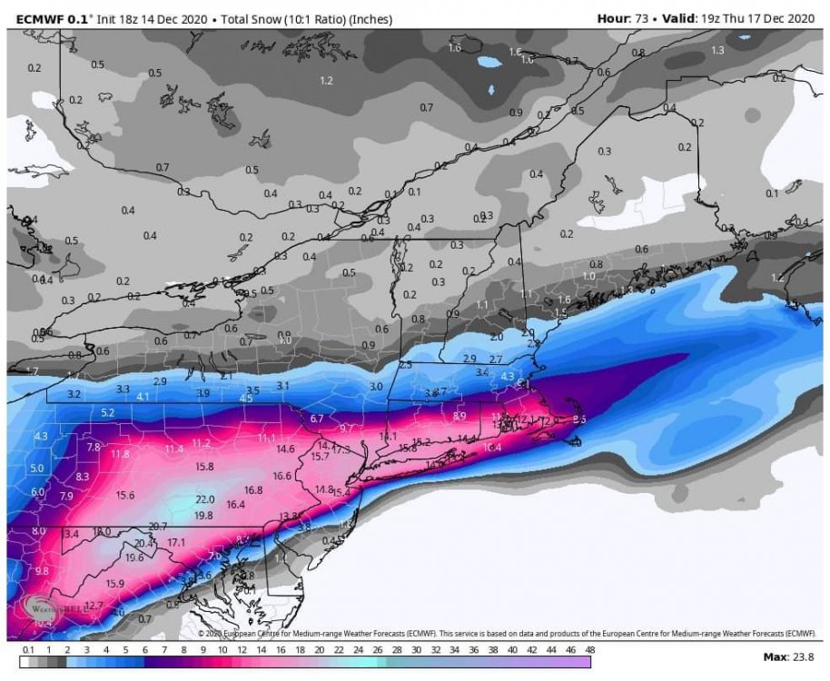
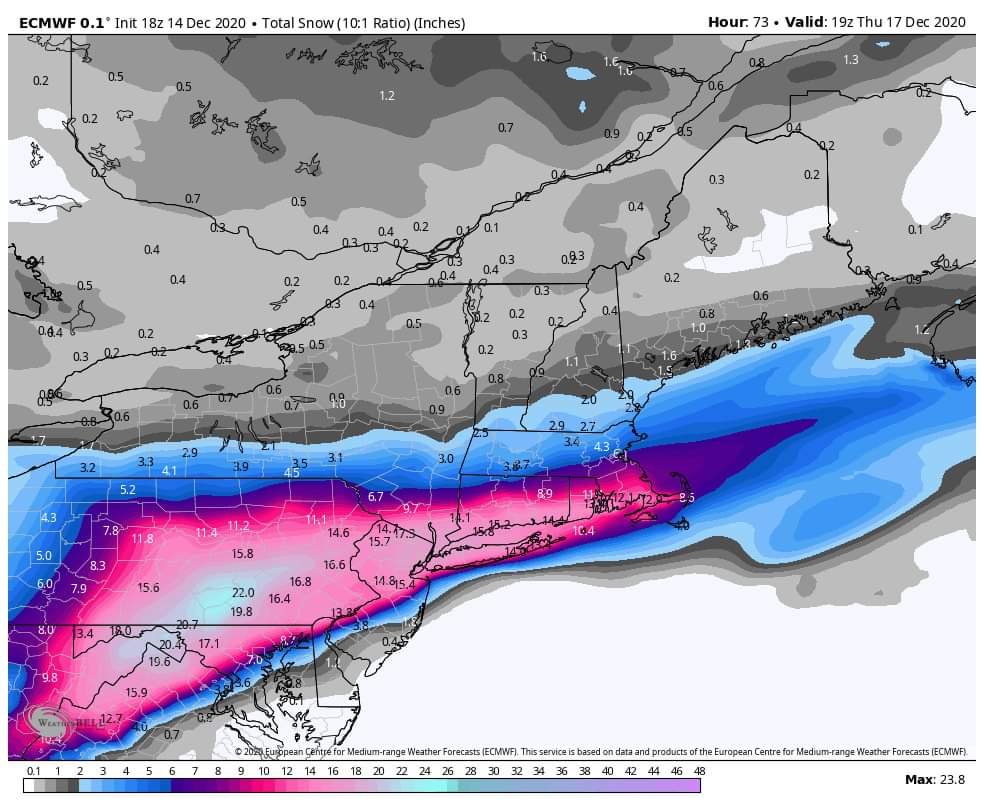
The high on the euro initialized due north of Pittsburgh and due east of Minneapolis fwiw.
-
Just now, catoctin wx said:
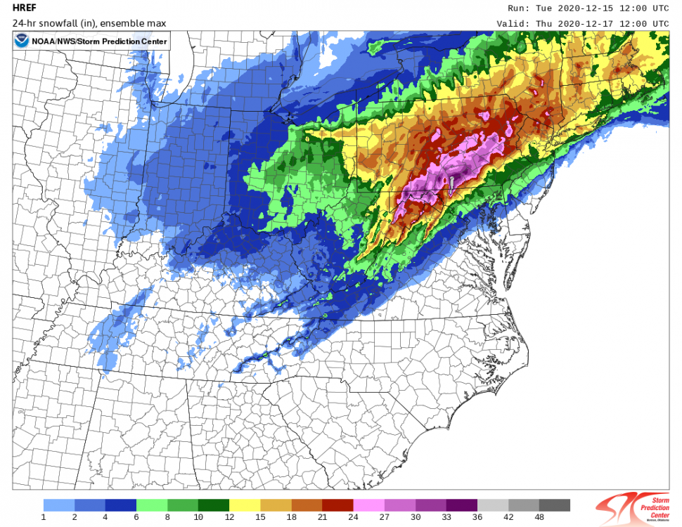
Ensemble max vs. ensemble mean
Do ensemble max charts even belong here?
-
5 minutes ago, baltosquid said:
And the weenie version of the same map...
I'm gonna pay attention to Frederick's totals to see if the HREF is picking up on the jackpot. No grades will be given but it will be fun to check.
What do you mean by weenie version? How are they different?
-
1 minute ago, jaydreb said:
Does GFS ever even turn us to plain rain on the western side of the beltway? Haven’t looked at the soundings but from precip type maps looks like mostly frozen (sleet)?
yes

-
From Mike Thomas: " For what it's worth, long range HRRR gets about 80% of the storm now and has heavy snow to sleet in DC and not full transition to rain. 0z GFS was a mix/rain dud for DC though. NWS did not change much. "
-
Amazes me how so many NFL coaches don't teach their players to focus on clock management. The Ravens won, because Cleveland left them with a minute to go down the field and kick a field goal.
-
Wow, check out the difference in the positioning of the high between the 3km NAM nest and the HRRR!

-
1 minute ago, Weather Will said:
WB 3k NAM, actually if this verifies a lot of people will be happy and roofs will be collapsing in N. MD

50?! LMAO
-
 1
1
-
-
5 minutes ago, AmericanWxFreak said:
RPM cuz why not
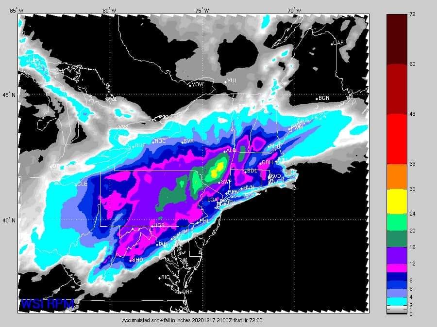
Why do I have to squint to see D.C...
-
7 minutes ago, AmericanWxFreak said:
That doesn't look like any change for D.C.
-
 1
1
-
-
I've said this before, but Mike Thomas's Facebook page from Fox5 is a really good page to follow! He really dives into the technicals. He believes D.C. has a good chance for a very brief heavy burst of snow before the rain takes over.
-
2 minutes ago, WxUSAF said:
WBAL had a pretty good map earlier, at least prior to any 12z/18z changes. I don't get just ripping the RPM snow map as a forecast. WJZ has this pretty terrible looking maps, but I guess 4-6" around Baltimore is reasonable.
What's that white spot just north of D.C.?
-
Just now, H2O said:
Good thing we've moved on from arguing about the models to what's a top 5 HECS in Dec
My bad
-
2 minutes ago, poolz1 said:
Thought the same thing...maybe records go back further for the cities than IAD?
IAD snowfall only goes to 1960. Good call
-
1
-
-
1 minute ago, losetoa6 said:
15-20" in southern, Pa in mid December is definitely HECS material
 . Imo ...Definitely some local areas will see that most likely as currently modeled. Hopefully N.Md is one of them lol.
That's the one area that might be able to do it.
-
1 minute ago, 40westwx said:DecemberDCBaltimoreDulles16.6"200920.4"196624.2"196616.2"196220.1"200921.4"200916.1"196617.1"190415.9"196914.5"193215.6"196014.3"196213.2"1904,194514.7"193211.9"1982
Still not a hecs
-
15 minutes ago, CAPE said:
Browns over the Ravens tonight. They are simply better right now, and the Ravens will again make enough mistakes and commit enough critical penalties to lose. The Browns smell blood with the Steelers in free fall. They win and they are one game back.
When was the last time the Browns beat the Ravens?
-
One thing we have going for us is La Nina years aren't modeled well.
-
4 minutes ago, 40westwx said:
The Euro shows top five for BWI. Thats a HECs
Feb 9-10 2010 is ranked 10th at BWI with 19.5". https://www.weather.gov/lwx/winter_storm-pr#TopDaySnowfall
-
1
-
-
1 minute ago, Climate175 said:
I'm not sure where you are located, but If you are N and W of I-95, then that would be expected.
Nobody is getting a hecs.
-
1 minute ago, 40westwx said:
That map isnt right.. you need to show the kuchera one.. it gives you more snow and the more snow the better
ttb doesn't have kuchera
-
2 minutes ago, chris21 said:
The accumulated snow depth map can be hit or miss.
10:1 isn't much different in this case
-
1 minute ago, clskinsfan said:
DC does snag a couple of inches on the backend.
Nope

-
gFs

December 16/17 Winter Event
in Mid Atlantic
Posted
That high is just moving too fast.