

NEG NAO
-
Posts
7,490 -
Joined
-
Last visited
Content Type
Profiles
Blogs
Forums
American Weather
Media Demo
Store
Gallery
Posts posted by NEG NAO
-
-
22 hours ago, LongBeachSurfFreak said:
This guys supposed to be a pro? This is one of the most idiotic comments I have ever read. And that says allot around here.
you can't trust him anymore because when he made his video canceling winter the rest of the way he backed himself into a corner - also I can't understand why anyone would pay money for his forecasts and insight when there are so many free and better forecasters out there...………...
-
9 hours ago, snywx said:
DT

this is upside down compared to the 12Z NAM and 12Z ICON which has all the heavier amounts in southern NJ
-
I just re - discovered the vendor thread so we can get all the conversations about what the paid vendors are talking about out of the main threads ………….lets see how many can follow directions around here
-
Feel GFS feedback problem is jumping storm out to sea too much IMO, Almost every major NYC storm in past 25 years has been out to sea on the GFS 4 days before. Maybe this is GFS coup, but the feedback fairy likely causing problems, so expect model to correct west
-
 1
1
-
-
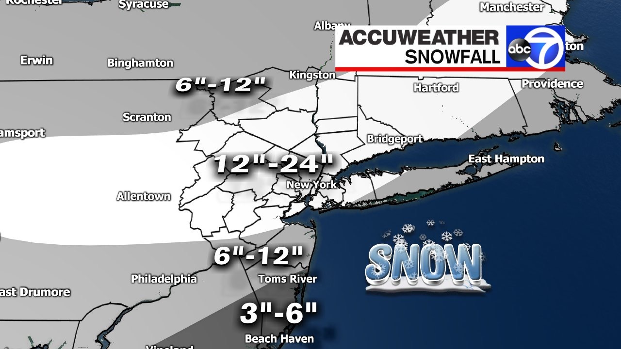
A potential winter storm is brewing for next weekend with heavy snow a threat for Saturday into Sunday morning.
Details on the way! -
55 minutes ago, Rjay said:
These models have been playing catch - up for a while the actual result for December will show the central and east as a wide chunk of real estate below to well below normal as the blocking takes hold in an almost perfect position for a few weeks at least - this cold outbreak could rival 2013 - 2010 and 1989....
-
I fell off the potty.............
-
-
21 hours ago, BxEngine said:

-
-
I think at this range its a good idea to have 12 - 24 because of all the uncertainties regarding banding and possible mixing in some areas..........
17 hours ago, weathermedic said:Jeff Smith from Channel 7 in NYC (AccuWeather outlet) just updated snowfall amounts

-
39 minutes ago, Rtd208 said:
According to Steve D. "the pattern should remain active and on the cold side until mid February then Spring is on the way". The way this winter has gone and how the models have handled things even in the shorter ranges I am taking everything with a grain of salt. I will laugh if we wind up seeing our biggest snowfall of the winter on March 1st.
The prime example regarding models and short range surprises is the January 7th storm which forecasters had to increase amounts and issue upgraded warnings during the storm - don't be surprised if that happens again at some point the remainder of the winter...........
-
-
Joe Cioffi says around an inch Thursday Nights and Saturdays
-
20 minutes ago, Brian5671 said:
oh Christ....that's our JB, always swinging for the fences!
exactly - and after his "December to Remember"
-
JB in his public daily summary says UKMET will verify phasing will occur = East Coast Blizzard This Weekend
-
no 90's in site as this stubborn pattern continues with a blocked trough in the northeast preventing the heat ridge from expanding into our area
http://wxweb.meteostar.com/sample/sample.shtml?text=kewr
-
http://wxweb.meteostar.com/sample/sample.shtml?text=KEWR
It looks like we have a shot for some 90s next Wednesday and Thursday.
doesn't look like we will reach 90 - this mornings GFS once again keeps temps well below 90 for a couple weeks . First we have to break out of this pattern we are in with troughing in the northeast
http://wxweb.meteostar.com/sample/sample.shtml?text=kewr
you can really see what is going on with this loop
http://www.weather.unisys.com/gfs/gfs.php?inv=0&plot=850®ion=us&t=l
-
Looks like we will not have any 90 degree days in May this year -
http://wxweb.meteostar.com/sample/sample.shtml?text=kewr
Also if we have a cooler summer we can avoid the increasing chances of electrical blackouts - we almost had a widespread one this past winter
-
Becoming more and more likely that we will not see our first 90 degree day in the metro until after Memorial Day which is the 26th this year.
-
Time to start tracking the 90 degree days. Will post a summer thread to track any heat as well.
This year Im going a bit above avg and on par with last year with 1982/2002/2006/1986 the strongest analogs
EWR: 23
NYC: 16
LGA: 20
JFK: 11
EWR: 14
NYC :12
LGA : 13
JFK : 11
here in the northern mid atlantic - IMO we will be well north of the heat ridge which will only poke into our area for brief periods from early June through late August - we will also have the "ring of fire" visit us form time to time being north of the high pressure ridge with some decent storms followed by cooler air and then in mid August the tropics start to get active with above normal precip here August through September.
-
looks like the heat wave will extend through at least Saturday - 7 days of 90's this week bringing the total to 20 for the season at Newark - only will need 4 to tie 2012 by July 31 - looks like July will end up being well above normal again ...........
-
6 days of 90s in 5 days would probably set some sort of record.
corrected - happy now ?
-
we should add about 6 more 90 degree days this coming week - Sun - thru Fri -which would bring the total for the year to 19 at Newark still less then last year thru July 19. The total at Newark in 2012 thru July was 24 ......


November 2019 General Discussions & Observations Thread
in New York City Metro
Posted