

Henry's Weather
-
Posts
1,573 -
Joined
-
Last visited
Content Type
Profiles
Blogs
Forums
American Weather
Media Demo
Store
Gallery
Posts posted by Henry's Weather
-
-
What's the response if the eps hold serve?
-
Glad this run progression occurred at D4 and not D1
-
@40/70 Benchmark Think you'll release a post tonight?
-
I feel like I will lose less sleep over the big threat if I focus on the small threat until it's passed
-
 1
1
-
-
Might be beneficial for weenies like myself to focus on the Monday threat which seems to be increasing based on GEFS, and then worry about Wednesday-Thurs.
-
Just now, TauntonBlizzard2013 said:
I’m not sure why the duration fetish from some.... it’s modeled to be a great event... who cares if the meat is only like 12 hours?
Probably because duration allows for a higher ceiling and people want 2 feet
-
 1
1
-
-
Do we care about NAVGEM or is it just a weenie model?
-
Just now, dendrite said:
Kinda, sorta, not really.
So just code for an early miller B redeveloper?
-
Is miller C a thing? I've heard the term jockeyed around
-
Probably best to not be in the jackpot by day 5. Hopefully Mr. 40/70 is right about holding onto that primary for a little longer
-
Someone page JoeSnowbos and have him start the thread
-
2
-
1
-
-
We want the Monday crap to move fast for midweek, no?
-
Looks like we go from coastal track pattern to overrunning pattern as -NAO decomposes
-
1
-
-
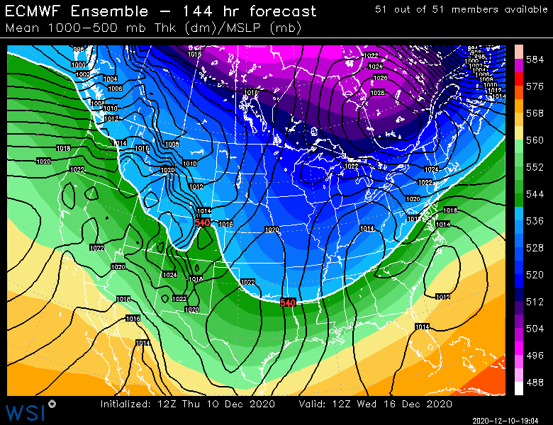
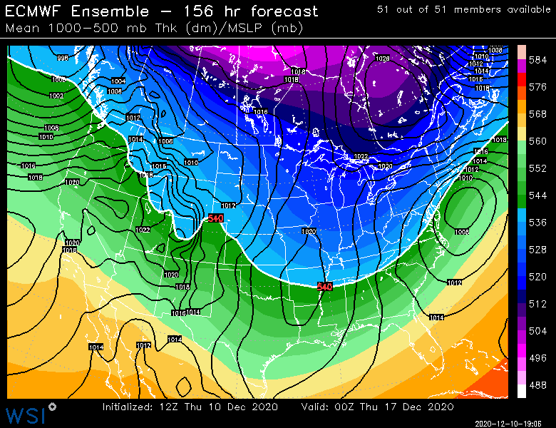
GEPS are northwest, closer to climo:
stole from another thread

-
Been worried about suppression depression since 12z yesterday. That confluence is strong man
-
1 minute ago, RDRY said:
What is the difference between the GEPS and GEFS?
GEPS is canadian ensembles, GEFS is gfs ensembles
-
1
-
-
1 minute ago, Typhoon Tip said:
We've talked about this 'conditioning' aspect many times in the past but yeah... Those of us that remember the scorn and spurn 1980s ... a 6-10" was a juggernaut.. We had more than a few storms that decade that were billed as ... " the biggest event since 1978' " and well, I guess 10.4" was in fact the biggest event since 1978 until 1992 or thereabouts...
Oh right - yeah..... I guess Cape Cod got clipped by a couple of whitecanes but ... don't get me started on 1987's debacle January that year - the famed 4th period blizzard warning that verified partly sunny in 6 F cold while the Cape was denuded of all life...
Anyway, those that came into sentience since that decade which ..probably is a considerable population of this type of social mediaspheric engagement frankly .. they don't realize this handing foot deep snow event out like Pez dispensing is unique to this ... auh... maybe it's a climate change thing - I dunno. But it's not the way anyone older than maybe 33 thinks as normal -
If you're a 24 year old you only have donut stuffing machine with just a few bad winters... And that's what's interesting about the wind 2000 era: two of the worst winters I recall happened since 2000, ...in an era where I've 300 % more snow than I remember spanning decades prior -
My formative winters were from 2008 to 2011, so not only am I young, I'm spoiled
-
Man i miss the days when storms were all surprises so a 6-10 inch deal wasn't "disappointing"
-
5 minutes ago, Typhoon Tip said:
Interesting ... I guess that storm did actually get down to respectively ... Hm... I swear I remembered that being a weaker - it may have also been a situation where the damage was already done - so that this was upon exit and not really doing as much as that looks suggest -
I remember something peculiar about that storm as being superb snow generation relative to its look either way.. But, this is the 7th and 12z
I do wonder if you were thinking of Feb 17-18th, 2003
-
1 minute ago, Typhoon Tip said:
I'm the one who said that to him back then by the way... Out of the mouths of babes and onto television --
Yeah, that storied storm - you're talking about December 2003, 5-7th ?? - That had a bitter cold air mass packed into eastern Ontario. I remember the cold exerion down the coastal plain/damming and burier jet ... just insane. Enough that it sandwiched the CF all the way down in, ..well, almost to Sandwich.. Exaggerating to make the point here but it was like 42 F at the Sag. bridge and 22F more 5 miles west of there - something like that. I know it was 19 F up where I was living in Winchester Mass at the time ...which is actually S of Woburn down I-93 ...
I think we got 18" of pow pow out of that and managed a bare ground x-mass - haha
Oh yeah, I was referring to PDII, which was like a 1013 mb low or something crazy?
-
2 minutes ago, Typhoon Tip said:
Once there ... sure!
I mean I'm not trying to be a deb downer ...and I realize I'm hammering this point to no avail ( lol ...) but I just don't like the shallow N-S coordinate while raging 100 to 150 kt mid tropospheric jet and flat PNAP ... transporting open longitudinal waves off the Pacific like that whole lead up is.
It may happen...okay. Fine... and I agree, as is? That's a fine tasty look. I tell you what *if* *if* *if* that pattern morphs successfully into that configuration ( for the folk reader - ) you wouldn't need a hugely powerful system to create a prolific snow result. The kinematic structure is quite superb in that set up ... that's a 'snow machine' look .. perfect 700 mb easterly anomaly running up over a steadily backing wind with depth... NNE over interior .. very cold column... wow -
I just don't like how we get there... Hope it does though - this is some seriously boring weather otherwise, huh
kinda like 2003? (weenie solution caveat)
-
 1
1
-
-
Given the tenacity of this block, I'm preparing myself for potential suppression depression. In this situation, maybe RNA is favorable for NE?
-
Just now, 40/70 Benchmark said:
Looks like a miller B that is displaced to the south because of the block...almost like something out of 2010.
my happiness depends on which part of 2010 you are referring to... lol
-
Just now, CT Rain said:
Don't hate the look!
look at that CAD signature, right off the pages of my KU books
-
1
-

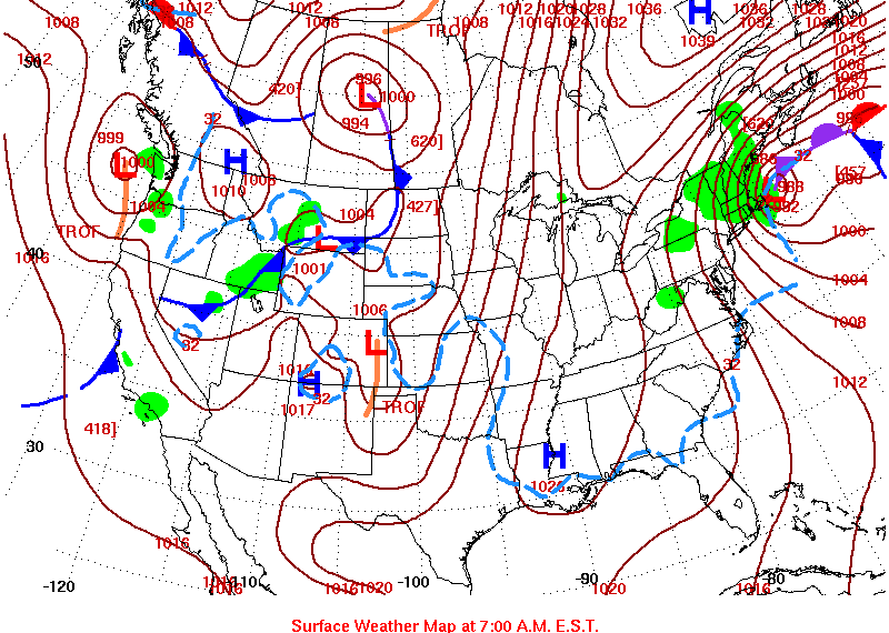
Active mid December with multiple event potential
in New England
Posted
What was it, like 38 inches march 2018?