

Henry's Weather
-
Posts
1,479 -
Joined
-
Last visited
Content Type
Profiles
Blogs
Forums
American Weather
Media Demo
Store
Gallery
Posts posted by Henry's Weather
-
-
5 minutes ago, Typhoon Tip said:
Interesting ... I guess that storm did actually get down to respectively ... Hm... I swear I remembered that being a weaker - it may have also been a situation where the damage was already done - so that this was upon exit and not really doing as much as that looks suggest -
I remember something peculiar about that storm as being superb snow generation relative to its look either way.. But, this is the 7th and 12z
I do wonder if you were thinking of Feb 17-18th, 2003
-
1 minute ago, Typhoon Tip said:
I'm the one who said that to him back then by the way... Out of the mouths of babes and onto television --
Yeah, that storied storm - you're talking about December 2003, 5-7th ?? - That had a bitter cold air mass packed into eastern Ontario. I remember the cold exerion down the coastal plain/damming and burier jet ... just insane. Enough that it sandwiched the CF all the way down in, ..well, almost to Sandwich.. Exaggerating to make the point here but it was like 42 F at the Sag. bridge and 22F more 5 miles west of there - something like that. I know it was 19 F up where I was living in Winchester Mass at the time ...which is actually S of Woburn down I-93 ...
I think we got 18" of pow pow out of that and managed a bare ground x-mass - haha
Oh yeah, I was referring to PDII, which was like a 1013 mb low or something crazy?
-
2 minutes ago, Typhoon Tip said:
Once there ... sure!
I mean I'm not trying to be a deb downer ...and I realize I'm hammering this point to no avail ( lol ...) but I just don't like the shallow N-S coordinate while raging 100 to 150 kt mid tropospheric jet and flat PNAP ... transporting open longitudinal waves off the Pacific like that whole lead up is.
It may happen...okay. Fine... and I agree, as is? That's a fine tasty look. I tell you what *if* *if* *if* that pattern morphs successfully into that configuration ( for the folk reader - ) you wouldn't need a hugely powerful system to create a prolific snow result. The kinematic structure is quite superb in that set up ... that's a 'snow machine' look .. perfect 700 mb easterly anomaly running up over a steadily backing wind with depth... NNE over interior .. very cold column... wow -
I just don't like how we get there... Hope it does though - this is some seriously boring weather otherwise, huh
kinda like 2003? (weenie solution caveat)
-
 1
1
-
-
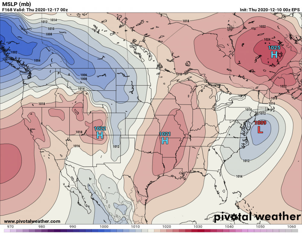
Given the tenacity of this block, I'm preparing myself for potential suppression depression. In this situation, maybe RNA is favorable for NE?
-
Just now, 40/70 Benchmark said:
Looks like a miller B that is displaced to the south because of the block...almost like something out of 2010.
my happiness depends on which part of 2010 you are referring to... lol
-
Just now, CT Rain said:
Don't hate the look!
look at that CAD signature, right off the pages of my KU books
-
 1
1
-
-
3 minutes ago, DTWXRISK said:
As much as I Want those snow maps to be right for NYC ne NJ coastal CT .. the surface temps are NOT great
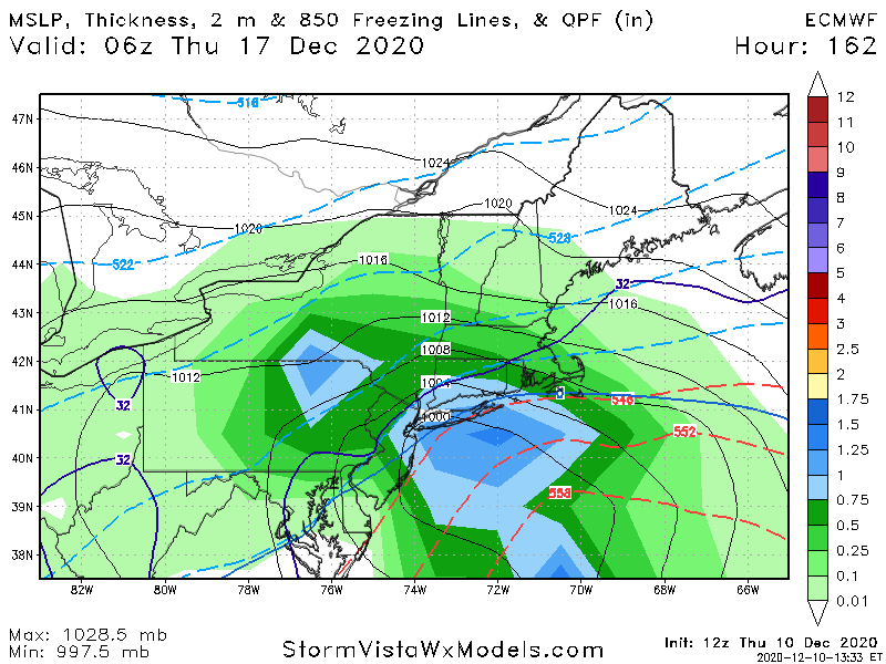
correct me if wrong, but looks like there is some disagreement along the coastal plain of SNE?
-
Just now, DTWXRISK said:
STOP POSTING THIS SHIT
as have been proven many times the SNOW maps on WXBELL AND weathermodels in these marginal situations are TOTAL CAPmarginal?
-
I'd imagine the typical north correction happens less under -NAO regimes? Someone enlighten me
-
1
-
-
Just now, dryslot said:
A whiff would be more in the cards then a cutter for next week.
With this stout 50/50 low for sure
-
1
-
-
I feel like ideally we'd want the high center west of Quebec City
-
absolute pornography
-
Let's hope we lose the bullseye in a couple runs, we all know how that goes
-
20 minutes ago, 40/70 Benchmark said:
TBH, I am okay with forgoing the PNA....I think this is a pattern that should target NE, and really reduce the likelihood of a whiff.
screw the MA lol
-
4 minutes ago, Chrisrotary12 said:
I'll take my chances with this
Nice to have actual cold air this time around
-
Pretty wild to be a 33 while Burlington, VT is at 38
-
im hovering at 33 at the moment with about a pasty half-inch
-
but we should cool to at least freezing, maybe 31 or 30 right?
-
 1
1
-
-
with the sun down, we should start to accumulate
-
BRING ON THE THUMP
-
HRRR gives my location ~1.5 inches of liquid from here on out... ripping right now.
-
1
-
-
gonna suck to have COVID and not be able to go out
-
flakes mixing in in Somerville!!!
-
 monster band in coastal plain on NAM in 2 hours
December 2020 Discussion
in New England
Posted
Man i miss the days when storms were all surprises so a 6-10 inch deal wasn't "disappointing"