PB-99
-
Posts
973 -
Joined
-
Last visited
Content Type
Profiles
Blogs
Forums
American Weather
Media Demo
Store
Gallery
Everything posted by PB-99
-
January 2020 General Discussions & Observations Thread
PB-99 replied to Rtd208's topic in New York City Metro

-
January 2020 General Discussions & Observations Thread
PB-99 replied to Rtd208's topic in New York City Metro
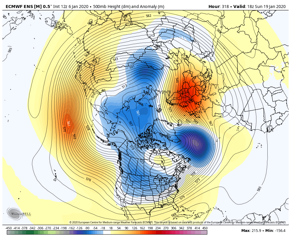
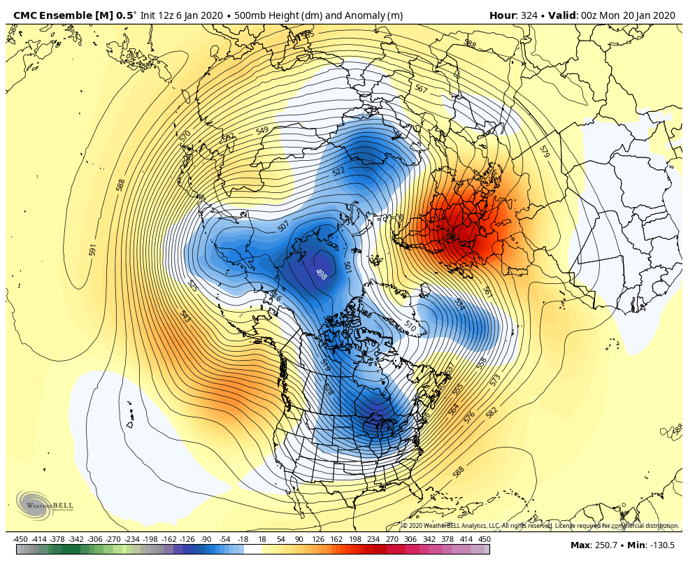
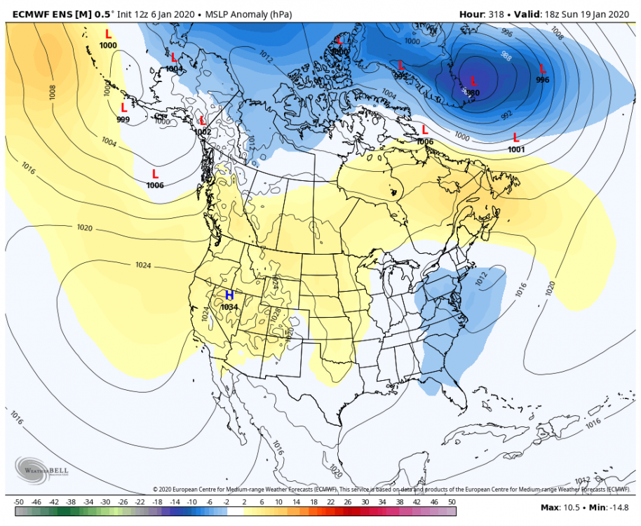
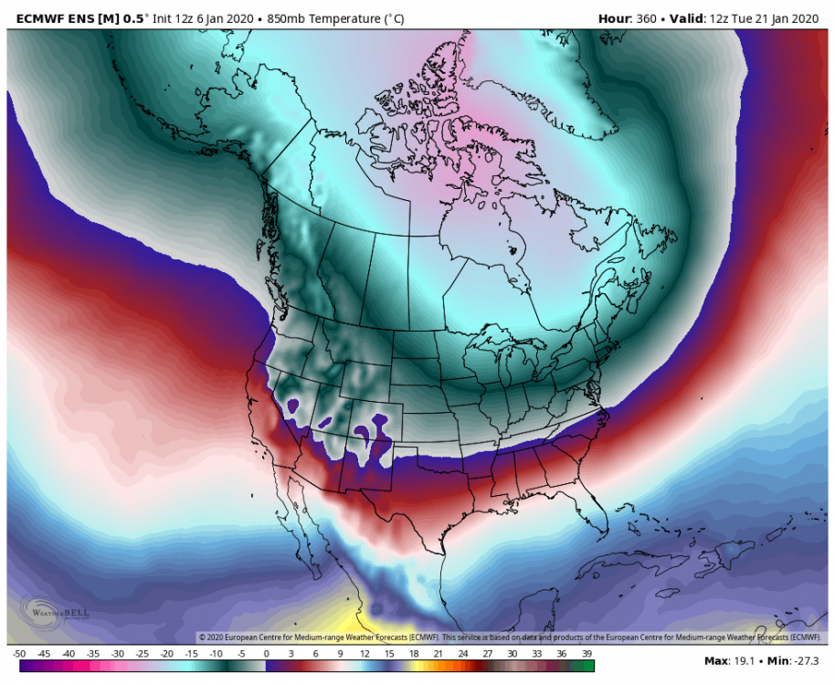
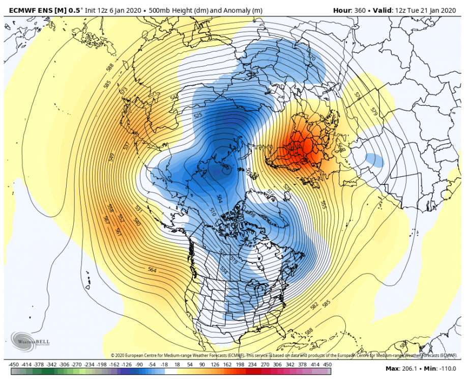
EPS DAY 13- 15 BYE SE RIDGE. Winter returns on Jan 19 on the EPS. Even if it`s 5 days early, that ejected a lot faster than the guidance would imply.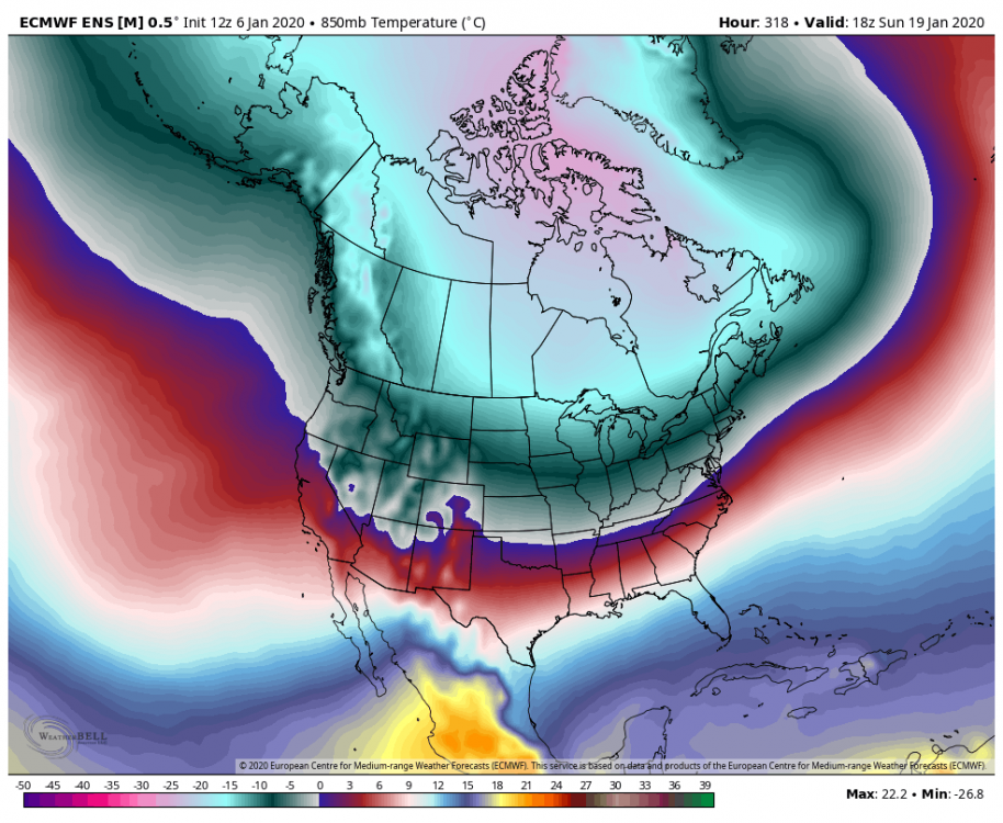
-
January 2020 General Discussions & Observations Thread
PB-99 replied to Rtd208's topic in New York City Metro
You will not erase 20 to 25 days of big anomalies. The cold will not just barrel in, you will def step down if the progression is 7 into 8 etc. The real cold would show up in Feb and could stay a while. But Jan is / has been cooked and no one is trying to deny that. The issue is when do you start to step down, after the 20th or after the 25th etc -
January 2020 General Discussions & Observations Thread
PB-99 replied to Rtd208's topic in New York City Metro
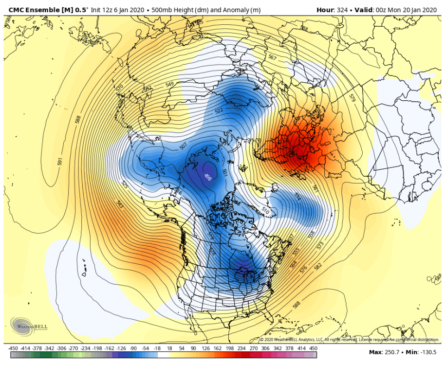
There`s no lag with the vortex in Canada lol. Once the forcing pushes the negative away from the WC it displaces the ridge. You can see it in it`s weak SD in the SE . The cold comes immediately. It`s a function of how fast can you get into 7 and displace the NEG E of the ROCKIES like the EPS and Canadian are doing. The GEFS is alone at 500. -
January 2020 General Discussions & Observations Thread
PB-99 replied to Rtd208's topic in New York City Metro
-
January 2020 General Discussions & Observations Thread
PB-99 replied to Rtd208's topic in New York City Metro
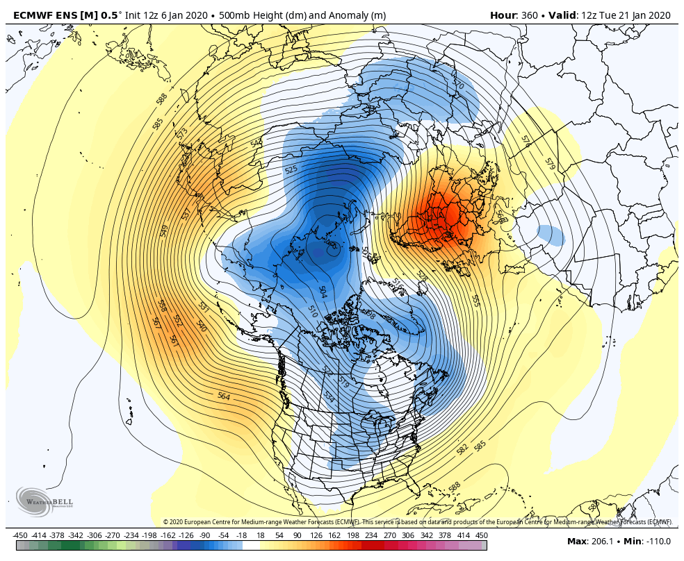
It will be in by Feb 1 if not a few days prior. But Feb 1 - March 20 has not changed. -
January 2020 General Discussions & Observations Thread
PB-99 replied to Rtd208's topic in New York City Metro
The trough axis will be back through or near the UWM by the 20th or so. The negative pushes away from the WC and the actual 0 line is down towards N/C The ridge will be starting to fade by the 25th, say goodbye after that.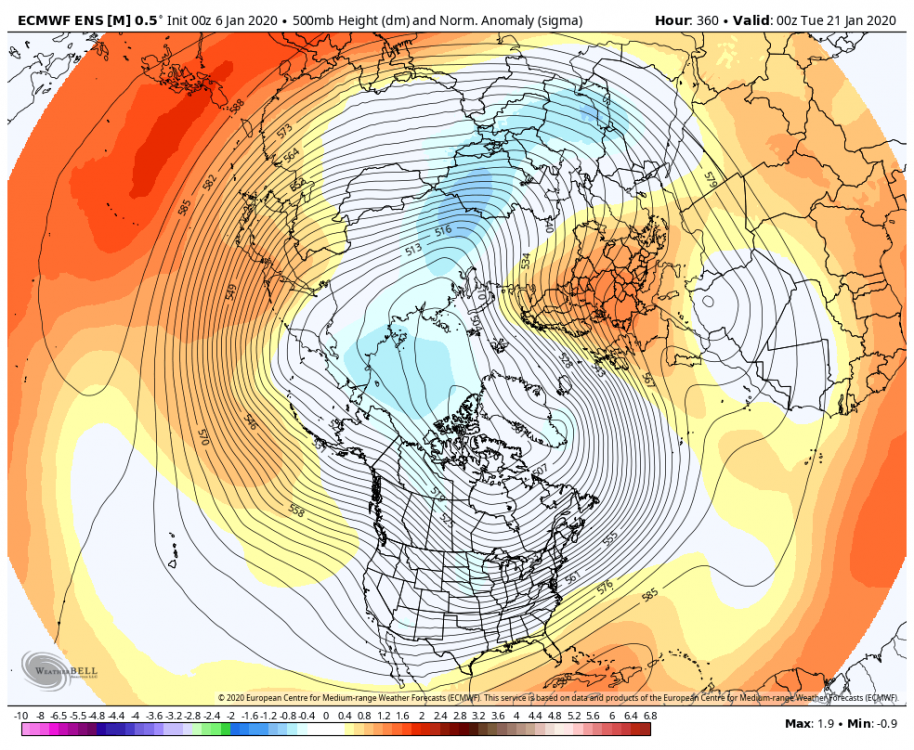
-
January 2020 General Discussions & Observations Thread
PB-99 replied to Rtd208's topic in New York City Metro
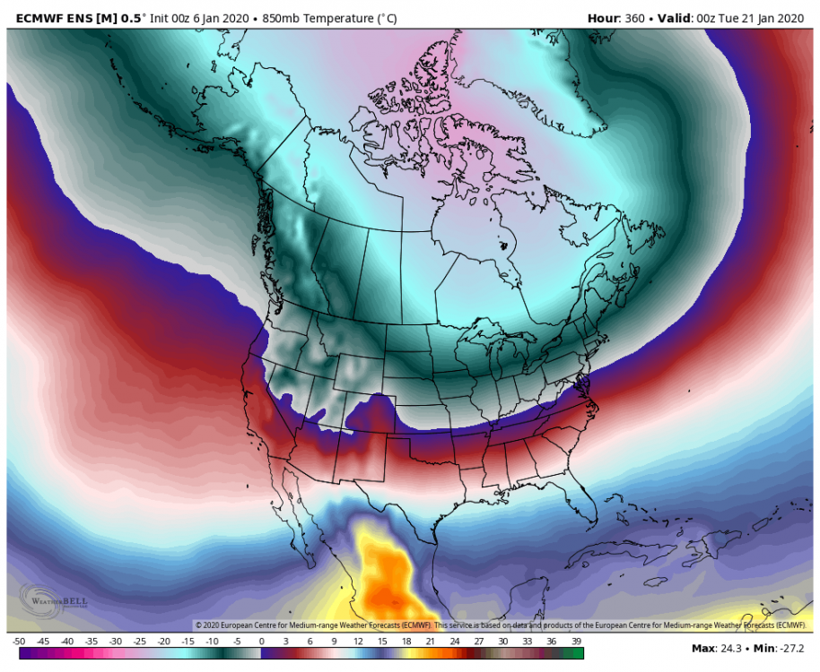
I think you are approaching p7 by the last week of the month ( and although not cold ) , it relaxes the ridge in the SE and with the TPV in Canada you will turn less warm in the east. But cold enough to snow as the real 0 line at 850 is S of you. Then you look for a Scan ridge to develop and that would further push on the ridge and allow that very cold air to dislodge south out of E Canada , by the time we head towards Feb. -
January 2020 General Discussions & Observations Thread
PB-99 replied to Rtd208's topic in New York City Metro
The wave is moving off , I think Timmy illustrated the Roundy plots perfectly. The wave heads towards 7 and that alone pushes the negative into the midsection. There is convection in the L/R popping up in 8 and maybe 1. If we come off after 7/8 we are prob in really good shape. It could come back out anywhere. Most Jan`s with the plus 1.5 SD into p5 get back to 8 and the guidance is showing you that. The water at the D/L is very warm, plus 30 c so as the wave moves over convection should fire. Root for 70 degrees next weekend, there have so many instances where big winter departures have yielded big reversals. There really isn`t anything pointing to the end of winter, we have been on hard break since Dec 21 and it prob lasts through Jan 20. Then the SE ridge is pushed south on the EPS. ( losing 4 core weeks of winter hurts the winter but does not mean it ends it ) . -
January 2020 General Discussions & Observations Thread
PB-99 replied to Rtd208's topic in New York City Metro
How would it do that ? -
January 2020 General Discussions & Observations Thread
PB-99 replied to Rtd208's topic in New York City Metro
Dec 21 2013 71 Feb 21 2018 78 Both of those years turned around, let`s hope that we hit 70 next weekend. -
January 2020 General Discussions & Observations Thread
PB-99 replied to Rtd208's topic in New York City Metro
Chris, 15 of the 1st 21 days of Dec were BN @ KNYC. You got a SE ridge on the 9/10 as one cut and another warm up 13/14. There were 3 small snow events because of the trough in the means. You are talking about the 9th`s event which was 1 event and not indicative of the month or what was prevalent for the 1st 21 days. -
January 2020 General Discussions & Observations Thread
PB-99 replied to Rtd208's topic in New York City Metro
We have been in a POS TNH for 2 years. What was posted was the period from Nov 1- Dec 20 when you rotated through all the cold phases early on. So now if you do that again in Feb you will get the same response IMO. -
January 2020 General Discussions & Observations Thread
PB-99 replied to Rtd208's topic in New York City Metro
from above. " You didn`t have a SE ridge as Nov ended - 3.8 and through Dec 22 KNYC was - 2.7 " The 1st 20 days are below , please don`t add in the last 10 days to make your argument when I specifically said the 1st 22 days. There was no SE ridge early on. The back 10 days were well forecast , expected and spoken about.
-
January 2020 General Discussions & Observations Thread
PB-99 replied to Rtd208's topic in New York City Metro
Well I am S of NYC and I got 6 in December and so did PSV who is E of NYC and both of those #s were AN. That retrograding Scan ridge helped allow the heights to get pushed on. Look at the mean 500 for those 5 weeks , there`s a trough in the east in the means. NYC only averages 4.8 inches in Dec, early climo goes against big snows unless there`s real blocking. You didn`t have a SE ridge as Nov ended - 3.8 and through Dec 22 KNYC was - 2.7 The ridge really appeared at the back end of Dec as the MJO entered the COD and on into p6. Here are the 1st 20 days of December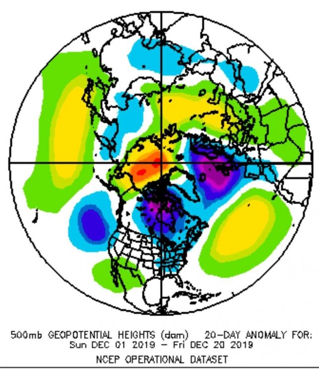
-
January 2020 General Discussions & Observations Thread
PB-99 replied to Rtd208's topic in New York City Metro
Agreed. You asked a question I was just answering it for you. Now I think we go there in Feb, I was AN for Dec and Jan and had Feb 1- March 20 as my core of winter. Fingers crossed. -
January 2020 General Discussions & Observations Thread
PB-99 replied to Rtd208's topic in New York City Metro
Nov 1 - Dec 20 it took a break as the MJO forced in 7 / 8 / 1 / 2. The SE ridge was non existent because of that forcing. We were aided by a retrograding Scan ridge which the GEFS is now hinting at. If the MJO goes back towards 8 like I think it will the SE ridge will get pressed on. That`s what I believe happens for Feb into early March.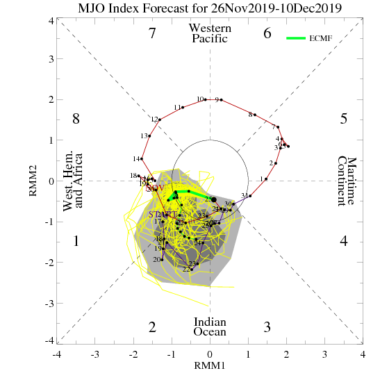
-
January 2020 General Discussions & Observations Thread
PB-99 replied to Rtd208's topic in New York City Metro
November -
January 2020 General Discussions & Observations Thread
PB-99 replied to Rtd208's topic in New York City Metro
Well the POS TNH has been a blessing for the UMW and NNE and obv hurt us. Nov 1 - Dec 20 was WBN , No ridge Dec 21- Jan 20 ends WAN , Big ridge What does Jan 21 - March 10 hold ? There`s your winter. I think the puke period is a break and not the end of winter. -
January 2020 General Discussions & Observations Thread
PB-99 replied to Rtd208's topic in New York City Metro
I am not putting any stock in any 1 model, I am just replying to your post that the SE would be on roids. That`s not what the weeklies show week 3- 4 -5. SE ridge is in the means, but muted compared to week 2. -
January 2020 General Discussions & Observations Thread
PB-99 replied to Rtd208's topic in New York City Metro
SE ridge is pushed S week 3 - 4 -5 on the weeklies, he doesn`t know what he is talking about -
January 2020 General Discussions & Observations Thread
PB-99 replied to Rtd208's topic in New York City Metro
The CFS dries everything out once this wave gets past d 15. If that`s right then FEB is big. ( which has always been my best month ) - -
January 2020 General Discussions & Observations Thread
PB-99 replied to Rtd208's topic in New York City Metro
A good sign is that starting on day 13 on the GEFS , the Scan ridge is showing signs of forcing higher heights towards Greenland. It begins to help force the trough south which presses on the SE ridge d 13 - d 15. -
January 2020 General Discussions & Observations Thread
PB-99 replied to Rtd208's topic in New York City Metro
Even when I look at the EPS and GEFS stringing LP out through the N/E it just looks like L/R lake cutters that drags a C/F through the area for a few days. Can`t have the negative in the SW unless the troughs that come out are all positively tilted and then can run the baroclinic zone. Even then I never like that look without blocking, the flow tends to ride further N as we get closer. -
January 2020 General Discussions & Observations Thread
PB-99 replied to Rtd208's topic in New York City Metro
And probably progresses thru 7 and 8 as well. Those RIMM plots were adamant about looping in p6 12 days ago and instead came out into 7 and 8. I have no gripe with the MJO going into 5 and 6. I do have an issue with those who think it just stays there, I believe it progresses well by day 20