PB-99
-
Posts
973 -
Joined
-
Last visited
Content Type
Profiles
Blogs
Forums
American Weather
Media Demo
Store
Gallery
Everything posted by PB-99
-
January 2020 General Discussions & Observations Thread
PB-99 replied to Rtd208's topic in New York City Metro
Once again we keyed on the fake loop on the GEFS We will strongly go into p7 and head into p8 One only has to look at the Jan 1 - 15 period when the MJO in p4 reaches an amplitude of 1.5 SD 9x out of 10 the MJO will circle into p8. And as I pointed out over the last few days in here that is where we are going. The EPS punts the trough off the WC by day 9 now. We are now inside 10 days, the GEFS is just slower but has finally come around. So to the " winters dead crowd " and those who were on wait until Feb 15, I think you can see that this gets back and gets back here before then. -
January 2020 General Discussions & Observations Thread
PB-99 replied to Rtd208's topic in New York City Metro
On 1/6/2020 at 11:13 AM, bluewave said: The risk for late January is that the the forcing gets stuck near phase 6 like the EPS shows. While these post day 10 forecasts can be low skill, the record SST’s west of the date line may support such an outcome. But a later MJO pulse in February could make it closer to phase 8. We’ll just have to wait and see. Yes you had a strong p 6 but the above stalled it there. While I was arguing that we were heading into p7 and away from p6 , I thought this to be your position. My apologies , has this since changed ? Do you know see us easily getting in p7 and heading on into p8 like I did/ do ? -
January 2020 General Discussions & Observations Thread
PB-99 replied to Rtd208's topic in New York City Metro
Ahem. Now you believe me huh -
January 2020 General Discussions & Observations Thread
PB-99 replied to Rtd208's topic in New York City Metro
Great post. -
January 2020 General Discussions & Observations Thread
PB-99 replied to Rtd208's topic in New York City Metro
Your concerns, 1. 2. You don`t need a -NAO in late Jan to snow on the E/C 3. a +EPO may be 1 gripe, but does not usurp the pattern. 4. The PNA can be NEG if there`s no SE ridge and a piece of the TPV comes across the CONUS. Canada is very cold and Pos tilted troughs can produce snow. 5. Compliments of Armando. Heading into p8 sometime after the 20th and prob p1 in early Feb. -
January 2020 General Discussions & Observations Thread
PB-99 replied to Rtd208's topic in New York City Metro
Comfy. -
January 2020 General Discussions & Observations Thread
PB-99 replied to Rtd208's topic in New York City Metro
I am not advocating for the abyss, in fact prob N 2m`s in the 11-15. But in late Jan that works. But what I do like is how the 0 line is pushed down to NC and there are some height rises over H/B. There`s a lot of HP showing up in Canada as the trough splits away. So I think things get interesting after we get past the 20th. -
January 2020 General Discussions & Observations Thread
PB-99 replied to Rtd208's topic in New York City Metro
Yes everyone the PNA stays - through day 13/14. No one is denying that, but the focus has been on the SE ridge. The EPS ejects a piece of the TPV cutting across the CONUS in the 10 -15. The forcing heading away from p6 may allow that trough that split in the LR and head into the lakes. All you need is a pos tilted trough to run under all the HP the EPS is seeing in Canada day 11 - 15 and winter returns ( or appears for the 1st time for some ) . If LP can be sat on and as long as the wave remains pos tilted the reduction of a SE ridge may allow you to be on the right side of the barroclinic zone. My pushback is with the winters over idea as well, nothing until mid Feb crowd. That is not what the EPS and GPS are telling you in the 10 - 15. -
January 2020 General Discussions & Observations Thread
PB-99 replied to Rtd208's topic in New York City Metro
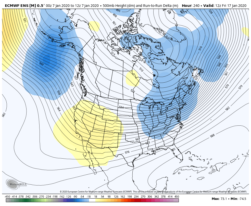
Run to Run Day 10 adjustment in the means / More trough in the east, more ridge out west. The PNA goes pos later in the period. The trough splits and a piece heads east. Let`s not start moving the goal posts and start talking about the PNA in here, the last few days we have been talking about the squashing of the SE ridge after day 12. Today it`s after day 10. ( this fix began 2 days ago on the EPS ) If you want to have another convo about the PNA we can have one, that takes longer to develop. But the SE ridge that you and I have been talking about over the last couple of days is doing exactly what I said it would do, feel the effects of the trough being ejected off the WC in the LR.
-
January 2020 General Discussions & Observations Thread
PB-99 replied to Rtd208's topic in New York City Metro
Brian, with all due respect we have been talking about a 3 plus week warm up away since before Christmas and hollowed out a 5 day break with more warmth on the backend. No one where I post missed this period from late Dec onward. -
January 2020 General Discussions & Observations Thread
PB-99 replied to Rtd208's topic in New York City Metro
Hey don`t look at me I was never a fan of the Strat warm idea. -
January 2020 General Discussions & Observations Thread
PB-99 replied to Rtd208's topic in New York City Metro
Like what ? Magic 8 ball ? PM me tonight`s powerball #`s pls -
January 2020 General Discussions & Observations Thread
PB-99 replied to Rtd208's topic in New York City Metro
Makes sense in p4 - p5. Prob doesn`t do that as you head away form p6 towards p7 -
January 2020 General Discussions & Observations Thread
PB-99 replied to Rtd208's topic in New York City Metro
Cutter Pattern.
-
January 2020 General Discussions & Observations Thread
PB-99 replied to Rtd208's topic in New York City Metro
That`s neither cutting or hugging. -
January 2020 General Discussions & Observations Thread
PB-99 replied to Rtd208's topic in New York City Metro
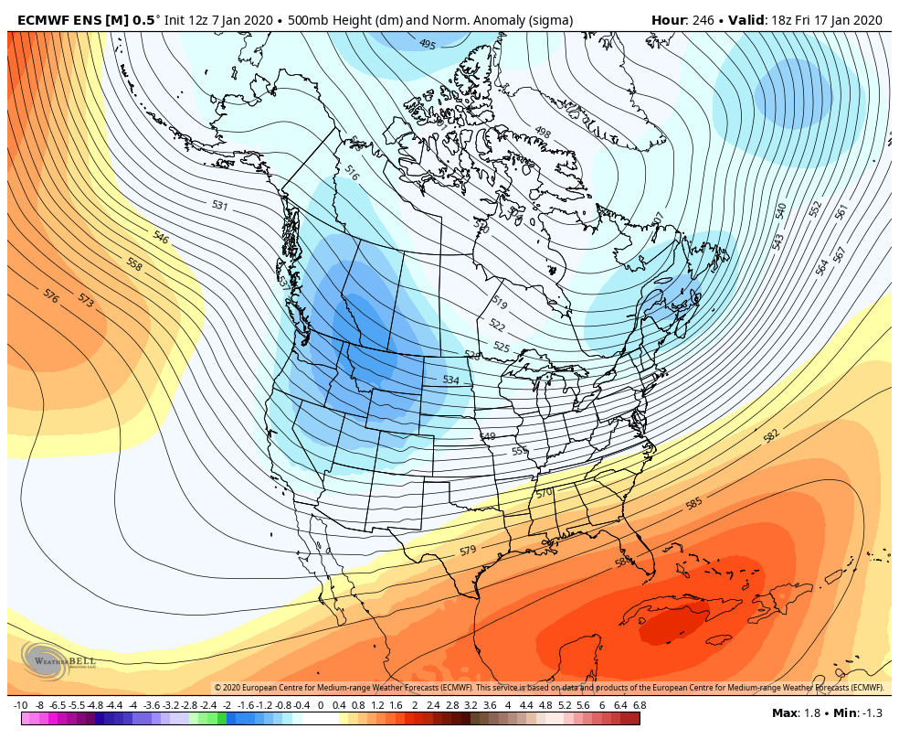
PNA goes + And there`s height heights over HB. I didn`t say it was " a good pattern " I said your SE ridge and torch are gone. And in Jan you snow with N 2m`s with - 850`s -
January 2020 General Discussions & Observations Thread
PB-99 replied to Rtd208's topic in New York City Metro
7 for Colts Neck 6 for U of Miami , 6 for PSV You will have a diff response in late Jan than you had in mid Nov -
January 2020 General Discussions & Observations Thread
PB-99 replied to Rtd208's topic in New York City Metro
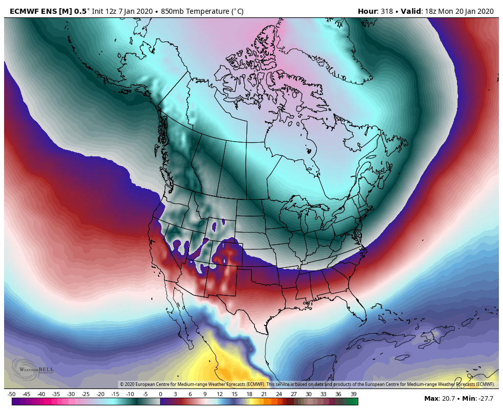
Sure over the next 5 days when there a 4SD ridge in the east , I think I hit 70 in CNJ. But then hat ridge is pressed down into Cuba day 11 - 15. If you cut any storm in even the best pattern we can go to 50. But the EPS accelerated kicking that trough off the W/C by day 10. It`s p7, the trough doesn`t come all the way east. But here is the EPS storm track post d 10
-
January 2020 General Discussions & Observations Thread
PB-99 replied to Rtd208's topic in New York City Metro
Because it was November and your departures of - 5 still don`t get it done on the coastal plain without blocking that early. There was a trough in the means at 500 because you were in the cold phases. Now what does that pattern do in late Jan to Mid Feb with where N are at that time ? -
January 2020 General Discussions & Observations Thread
PB-99 replied to Rtd208's topic in New York City Metro
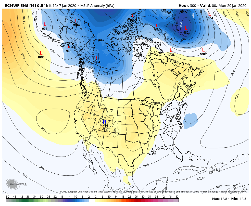
Fork, there`s a lot of HP day 11 - 14 over HB . Certainly not a KU look , but 540 thickness with - 5 at 850 by day 10 ends the torch.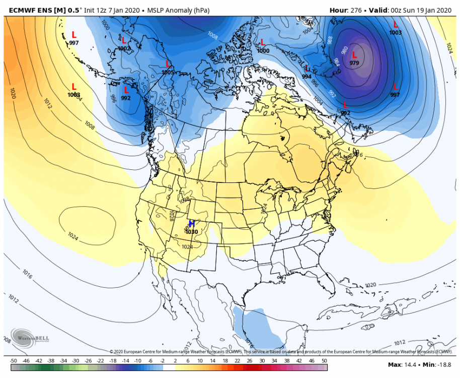
-
January 2020 General Discussions & Observations Thread
PB-99 replied to Rtd208's topic in New York City Metro
You had it Nov 1 - Dec 14. -
January 2020 General Discussions & Observations Thread
PB-99 replied to Rtd208's topic in New York City Metro
@Brian5671 you will warm day 3 - 9 and then the EPS has accelerated the change to winter regime.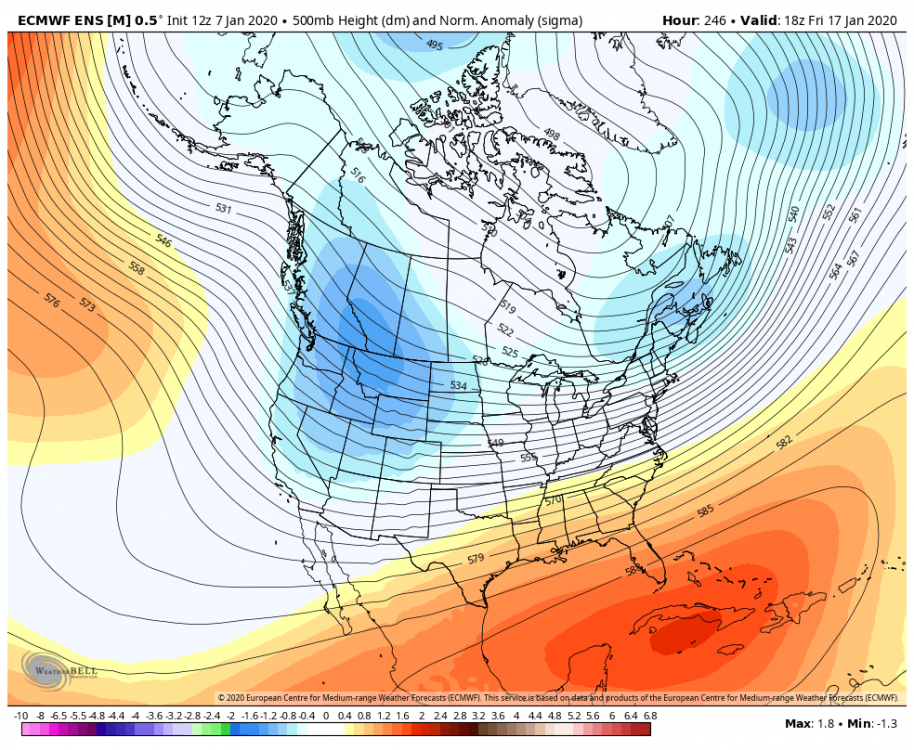
-
January 2020 General Discussions & Observations Thread
PB-99 replied to Rtd208's topic in New York City Metro
Huh, the euro is now drilling the trough into the midsection at day 10- not day 12 - not day 15 lol -
January 2020 General Discussions & Observations Thread
PB-99 replied to Rtd208's topic in New York City Metro
Another adjustment 3 runs of more trough in the east. Now the trough wants to dig into the midsection b d 10
-
January 2020 General Discussions & Observations Thread
PB-99 replied to Rtd208's topic in New York City Metro
There`s no argument, the guidance is quicker now.