

klw
-
Posts
4,822 -
Joined
-
Last visited
Content Type
Profiles
Blogs
Forums
American Weather
Media Demo
Store
Gallery
Posts posted by klw
-
-
2 minutes ago, powderfreak said:
But it's the GGEM. We all shovel a lot of GGEM snow.
I know but this time it was actually right.
-
 1
1
-
-
41 minutes ago, wxsniss said:
What an awesome storm... that WCB band through eastern MA 1-2am was one of the best I've seen in 25+ years in Boston
Multiple different mechanisms on display (WCB, mid-level frontogenesis, CCB) more geographically disjointed than what I'm used to seeing
This season already a great start with 2 over-performers (Oct 29, Dec 16), 1 big bust (Dec 5)
Still don't understand why not a single model had any clue on that mid-level fronto being so far northwest, intense, and stationary... do we know if the track of the ULL was very different than progged? Haven't had time to go through guidance vs. mesoanalysis to understand what happened.
The CMC was pretty darn close. Look at 12 Z yesterday.

And look at the Kuchera numbers that were spit out:
https://www.pivotalweather.com/model.php?m=gdps&p=snku_acc&rh=2020121612&fh=42&r=us_ne&dpdt=&mc=

It had the band just south of there for at least a few runs prior.
ex: 0z on the 16th

-
12 minutes ago, powderfreak said:
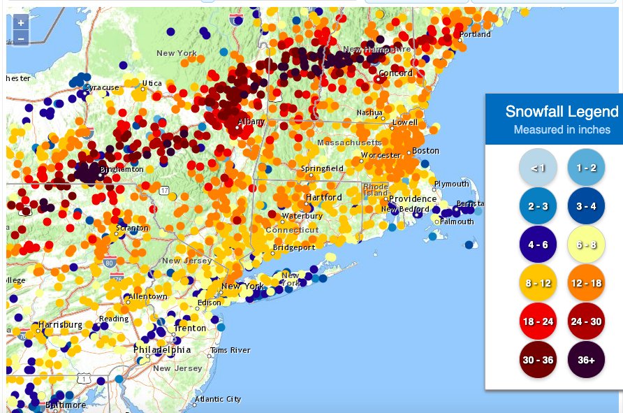
Can anyone think of another storm that had such a long axis of 40"+ reports to the NWS?
PA/NY/VT/NH on the list. This isn't like one weenie got excited somewhere or some isolated report. That's a legit axis of 40+ in a coastal storm.

Did Ludlow ever turn in a final total? They must have gotten a lot more after 9:50 am.
-
19.8 here which is actually my biggest in Vermont. Biggest in our Norwich time had been 18.7 though that was only 6 days after an 18.2 storm. Peacham we usually missed on the the heaviest- I don't remember anything over 16 in those years (09-16). South Royalton (92-02) I don't remember anything reached 18 (even 3/93) but lots were in the 14- 17 range.
Pretty easy to clean up but both shear pins went on the blower at the bottom of the drive so I will have to do a polishing up over the weekend.
-
1
-
-
From updated GYX AFD:
.NEAR TERM /UNTIL 6 PM THIS EVENING/...
1226 PM Update...
A dangerous and historic storm will continue for some areas
through the mid afternoon hours. The highest snowfall report in
New Hampshire as of noon time was 38 inches in Grantham. The
New Hampshire State record for a single storm is 49.5 inches.
Have updated snowfall totals for southwest Maine and central New
Hampshire. Extreme snowfall rates to continue for another 2 to
3 hours.
-
Were there any thunder snow reports up here? I don't recall seeing any posts about it.
-
18.8 now. 1.3 over the last hour but it is much lighter now. Wind seems to be picking up a bit however.
-
1
-
-
New BTV PI statement
https://forecast.weather.gov/product.php?site=NWS&product=PNS&issuedby=BTV
..Windsor County...
  3 S Ludlow            44.0  935 AM 12/17  At 1800 ft. elevation.
  Ludlow                41.0  950 AM 12/17  At 1500 ft. elevation.
  Windsor               39.0 1025 AM 12/17  Fire Dept/Rescue
  Springfield           38.0 1100 AM 12/17  Public
  Reading               38.0 1000 AM 12/17  Broadcast Media
  Chester               34.5  900 AM 12/17  Broadcast Media
  Weathersfield         32.0 1000 AM 12/17  Broadcast Media
  Brownsville           32.0  830 AM 12/17  Broadcast Media
  2 W Reading           31.0  945 AM 12/17  Broadcast Media
  2 S Ludlow            30.5  713 AM 12/17  Near South Hill
  Hartland              30.0 1010 AM 12/17  Public
  1 SW Hartland         29.0  900 AM 12/17  CoCoRaHS
  Woodstock             23.5 1050 AM 12/17  At 800 ft. elevation.
  2 S West Windsor      23.0  700 AM 12/17  CoCoRaHS
  2 NW Hartland         22.0  700 AM 12/17  CoCoRaHS
  North Hartland        22.0 1030 AM 12/17  Public
  Andover               21.5  815 AM 12/17  Public
  1 SSW Tyson           20.0  730 AM 12/17  Public
  Wilder                20.0 1035 AM 12/17  Public
  1 E Woodstock         18.0  800 AM 12/17  Co-Op Observer
  1 NNE North Hartland  18.0  730 AM 12/17  Co-Op Observer
  1 SE West Norwich     17.5 1100 AM 12/17  Public
  Quechee               16.0  800 AM 12/17  Public
  Barnard               13.0 1040 AM 12/17  Public
  2 NE Rochester        12.2  845 AM 12/17  CoCoRaHS
  Bethel                10.5 1030 AM 12/17  Public
  3 N Pomfret            9.5  700 AM 12/17  CoCoRaHS
...Rutland County...
  Danby                 33.0  830 AM 12/17  Broadcast Media
  4 W Pawlet            32.0  930 AM 12/17  Public
  Pawlet                31.0 1120 AM 12/17  Public
  3 ESE Shrewsbury      30.0 1100 AM 12/17  Trained Spotter
  Mt. Holly             27.0  905 AM 12/17  Broadcast Media
  West Rutland          27.0 1121 AM 12/17  Public
  Belmont               24.0  930 AM 12/17  Public
  3 SSW Wallingford     21.3  700 AM 12/17  CoCoRaHS
  1 NNW South Wallingf  21.3  700 AM 12/17  Trained Spotter
  2 SSW Mendon          18.0 1113 AM 12/17  Public
  Killington            15.0  700 AM 12/17  Public
  1 WNW Middletown Spr  14.2  600 AM 12/17  CoCoRaHS
  1 N Rutland           12.4  700 AM 12/17  CoCoRaHS
  Pittsfield            12.0  840 AM 12/17  Public
-
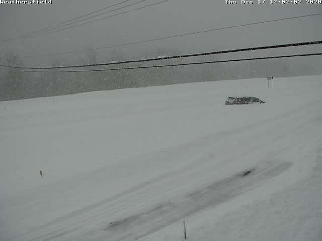
17.5" here as of 11am and it has picked up again. Amazing that further down Windsor County has totals 2 to 3 times mine!
-
17.5 inches now. 8.5 since 6:40 this morning.
-
Some healthy totals from NY/PA
https://forecast.weather.gov/product.php?site=NWS&product=PNS&issuedby=BGM
...New York...

...Broome County...
2 SW Nws Binghamton          41.0 in   0640 AM 12/17   NWS Employee
Vestal                       41.0 in   0730 AM 12/17   Public
2 S Binghamton               41.0 in   0800 AM 12/17   Public
Endicott                     40.5 in   0550 AM 12/17   Trained Spotter
2 E Vestal                   40.2 in   0700 AM 12/17   NWS Employee
2 SW Vestal Center           40.0 in   0730 AM 12/17   NWS Employee
Nws Binghamton               39.6 in   0700 AM 12/17   Official NWS Obs
West Corners                 39.5 in   0649 AM 12/17   Public
Endwell                      37.0 in   0622 AM 12/17   Public
Chenango Bridge              36.0 in   0742 AM 12/17   Public
2 SSE Vestal Center          35.0 in   0747 AM 12/17   Public
Binghamton                   30.5 in   0715 AM 12/17   Public
Lisle                        30.0 in   0626 AM 12/17   Public
Port Dickinson               30.0 in   0703 AM 12/17   Public
Nanticoke                    29.0 in   0636 AM 12/17   Public
2 NNW Port Crane             28.6 in   0615 AM 12/17   NWS Employee
Kirkwood                     24.0 in   0625 AM 12/17   Public
2 ENE Lisle                  23.0 in   0721 AM 12/17   Public
...Tioga County...
2 SE Newark Valley           44.0 in   0700 AM 12/17   Public
Owego                        40.0 in   0815 AM 12/17   Public
1 N Foster                   38.0 in   0630 AM 12/17   NWS Employee
Tioga Terrace                36.0 in   0600 AM 12/17   Public
Waverly                      32.0 in   0748 AM 12/17   Public
Lockwood                     26.0 in   0631 AM 12/17   Public
Berkshire                    25.0 in   0730 AM 12/17   Trained Spotter
...Pennsylvania...

...Bradford County...
Litchfield                   43.0 in   0800 AM 12/17   Trained Spotter
Troy                         36.0 in   0600 AM 12/17   Public
Sayre                        32.0 in   0647 AM 12/17   Public
1 S Sayre                    31.0 in   0545 AM 12/17   Public
Ridgebury                    31.0 in   0647 AM 12/17   Public
Towanda                      30.0 in   0626 AM 12/17   Public
-
Looks like smooth traveling on 93

Meanwhile on 1 91 near Springfield:
-
1
-
-
PIS about an hour ago:
..https://forecast.weather.gov/product.php?site=NWS&product=PNS&issuedby=BTV

.Windsor County...
  Chester               31.5  820 AM 12/17  Broadcast Media
  2 S Ludlow            30.5  713 AM 12/17  Near South Hill
  Windsor               30.0  908 AM 12/17  Broadcast Media
  1 SW Hartland         29.0  900 AM 12/17  CoCoRaHS
  Reading               28.0  800 AM 12/17  Broadcast Media
  2 N Springfield       25.4  700 AM 12/17  Public
  Weathersfield         24.0  830 AM 12/17  Dept of Highways
  Springfield           24.0  715 AM 12/17  Broadcast Media
  2 S West Windsor      23.0  700 AM 12/17  CoCoRaHS
  2 NW Hartland         22.0  700 AM 12/17  CoCoRaHS
  Andover               21.5  815 AM 12/17  Public
  1 SSW Tyson           20.0  730 AM 12/17  Public
  Hartland              18.5  720 AM 12/17  Public
  1 E Woodstock         18.0  800 AM 12/17  Co-Op Observer
  Woodstock             16.5  740 AM 12/17  Public
  Quechee               16.0  800 AM 12/17  Public
  3 N Pomfret            9.5  700 AM 12/17  CoCoRaHS
  1 SE West Norwich      9.0  645 AM 12/17  Public
  Bethel                 8.0  710 AM 12/17  Public
  NE Rochester           6.5  700 AM 12/17  CoCoRaHS
...Rutland County...
  Danby                 33.0  830 AM 12/17  Broadcast Media
  4 W Pawlet            30.0  830 AM 12/17  Public
  Pawlet                30.0  820 AM 12/17  Park/Forest Srvc
  Mt. Holly             27.0  905 AM 12/17  Broadcast Media
  3 ESE Shrewsbury      25.0  832 AM 12/17  Trained Spotter
  Shrewsbury            25.0  815 AM 12/17  Public
  Belmont               24.0  930 AM 12/17  Public
  2 ENE Shrewsbury      23.5  740 AM 12/17  Public
  3 SSW Wallingford     21.3  700 AM 12/17  CoCoRaHS
  1 NNW South Wallingf  21.3  700 AM 12/17  Trained Spotter
  1 WNW Middletown Spr  14.2  600 AM 12/17  CoCoRaHS
  Pittsfield            12.0  840 AM 12/17  Public
  Castleton             12.0  910 AM 12/17  Public
  1 N West Rutland      11.9  615 AM 12/17  CoCoRaHS
  1 SSE West Rutland    10.3  800 AM 12/17  CoCoRaHS
  Poultney              10.0  715 AM 12/17  Broadcast Media
  2 ENE Poultney         8.0  602 AM 12/17  Broadcast Media
  Forest Dale            7.5  815 AM 12/17  Public
  Sudbury                7.0  550 AM 12/17  Public
-
24 minutes ago, Damage In Tolland said:
IBM Graf FTW?
Problem for IBM is it had moved south yesterday and had much less up this way.
-
12 minutes ago, dendrite said:
My god this may be the heaviest I’ve seen it yet this morning. 16.5°F
The moment Dendy turned into Dave looking into the Jupiter monolith.
-
 2
2
-
-
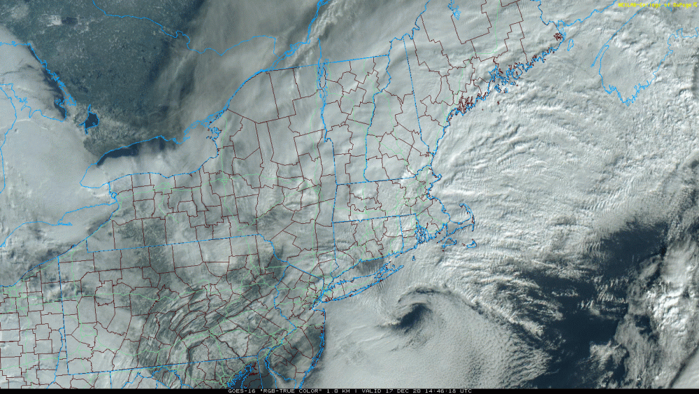
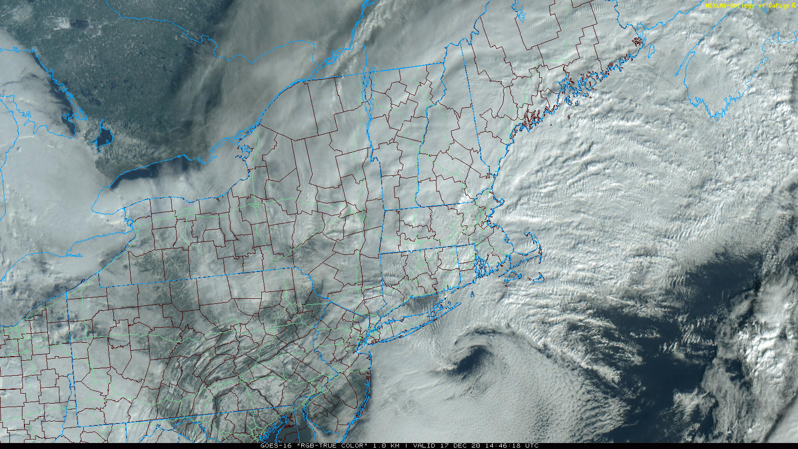
nice visual shot
-
2
-
-
15 inches here now. Gives me 6 inches in around 2 3/4 hrs.
-
2
-
-
Just now, mahk_webstah said:
What a band now! The video was just before the band intensified. Brian I think the NE wind is helping me as I’m on the south edge of the band. Man it blew up in the last few minutes!
Is that a cream colored Golden? She does not look happy to be filmed while pooing.
-
2.5 inches in the last hour, no wind to speak of
-
1 minute ago, dendrite said:
Weeeeeee. This will end up a new record for me.
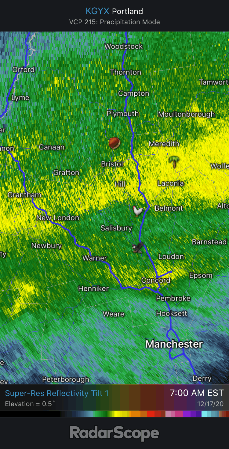
It seems like the band may be getting even a bit stronger
-
So for up here the best model would appear to have been the .......SREF family!
Canadian, HRRR, and NAM a close second.
Shudder.
-
2 minutes ago, Ginx snewx said:
Not being there to measure but knowing my yard there is a foot

And no new trees on the fence! Get well,
-
1
-
-
Another inch in the past 15-20 minutes.


Dec 16-17 obs/nowcast thread
in New England
Posted
the SREF also did well about placing the heavy stuff through that area.