

klw
-
Posts
4,487 -
Joined
-
Last visited
Content Type
Profiles
Blogs
Forums
American Weather
Media Demo
Store
Gallery
Posts posted by klw
-
-
Snow has really picked up the last 15 minutes
-
5 inches here, not much on the trees fortunately. Small flakes at the moment,
-
1 hour ago, dryslot said:
The new buzz phrase is the PDC maps.
PDC, how can I explain it
I'll take you frame by frame it
To have y'all jumpin' shall we singin' itExciting isn't it, a special kinda business
Many of you will catch the same sorta PDC is you with
Him or her for sure is going to admit it
When PDC comes, damn-- skippy I'm with itAre you down with PDC? Yeah you know me.
Who's down with PDC? Every last homie.
-
 7
7
-
-
https://forecast.weather.gov/product.php?site=BTV&issuedby=BTV&product=AFD&format=CI&version=1&glossary=1

The probabilistic data has become increasingly concerning across
Rutland, with ensemble forecasts depicting a near 100% chance of
wind gusts in excess of 60 mph. The forecast soundings indicate the
inversion layer just under summit levels with almost due east flow
that 65 to 75 knots at the top of the inversion layer. The GFS
isobars indicate the potential for significant wave breaking
Wednesday afternoon into Thursday night in Rutland County and
eastern Addison County. But even outside the core of the upper jet,
the potential for winds to mix across eastern Vermont and
through the Adirondacks has also increased, warranting a Wind
Advisory for a larger part of the region. If there`s any
consolation, this comes before much of the wintry weather.
These winds could produce downed trees and power lines across
the region and produce power outages well before wintry weather
takes place.
-
If looking for an interesting place to watch, there is a viewing party at the Northern Skies Observatory in Peacham.
https://www.facebook.com/events/2558212521019104/?ref=newsfeed
QuoteNorthern Skies ObservatoryDuration: 3 hrPublic · Anyone on or off FacebookDue to popular demand, the Northeast Kingdom Astronomy Foundation has decided to host a solar eclipse watch party at the Northern Skies in Peacham, VT! We'll have 1 minute of totality, so if you're in the Peacham area, feel free to join us - even if it's cloudy! We will have SAFE telescopes and solar eclipse glasses for a small donation!Check this NKAF Facebook page for late news!Thanks!See less -
Vermont going as far as closing the courts in the northern half of the state for the day. I assume most court offices will follow suit. No they aren't closing Thursday for the storm.
https://www.vermontjudiciary.org/news/public-notice-regarding-courthouse-schedules-april-8
April 01, 2024Public Notice Regarding Courthouse Schedules on April 8
Due to the upcoming solar eclipse event with anticipated road closures and high traffic volume, courthouse schedules will vary by location on April 8. Courthouses in the following counties in the northern part of the state will be physically closed to the public on April 8: Chittenden; Franklin; Grand Isle; Lamoille; Orleans; Caledonia; Essex and Washington. Persons wishing to apply for a relief from abuse order in those counties on April 8 during regular courthouse hours may call 1-800-540-9990.
Courthouses in the remaining counties will be open to the public on April 8 (except between 3:15 - 3:45 pm when all courts will be closed): Addison; Orange, Windsor, Rutland, Bennington and Windham.
-
BTV discussion this morning:
We know everyone wants to know what the forecast is going to be on
Monday. Drum roll please. The forecast for Monday is looking
spectacular across the North Country. A strong upper level ridge is
slated to move across New England Sunday night with surface high
pressure not far behind. With deep layer ridging building on Monday,
we should see strong subsidence in the mid to upper levels which is
typically tied to drier and more stable conditions. This upcoming
ridge will be no exception. Model soundings are beginning to show a
plethora of dry air in the mid levels Monday afternoon. We will
still likely see a few fair weather cumulus clouds as we should have
a weak layer of lift in the low levels but these clouds will likely
have limited vertical extent given the subsidence aloft. This should
make for great viewing conditions as mostly clear skies are now in
the forecast around eclipse time. Dry weather is expected to
continue into Tuesday before clouds and precipitation chances begin
to increase late Tuesday as another low pressure system tracks
toward the Northeast.
-
I think Powderfreak has been writing the BTV discussion:https://forecast.weather.gov/product.php?site=BTV&issuedby=BTV&product=AFD&format=CI&version=1&glossary=1
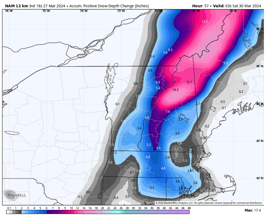
The biggest change as we enter into the
temporal realm of higher-resolution mesoscale and Convection-
Allowing Models (CAMs) time range has been a delayed onset of
winter precipitation as well as snowfall accumulation. While it
is tempting to use straight 10:1 SLRs or kuchera snowfall
amounts, the fact that we are two weeks after the start of
astronomical spring warrants a closer look at the thermal
profiles. While it is not impossible to accumulate snow at 34
degrees with mesoscale banding, the snow does have to come down
fast and furious in the valley locales. Besides the sun angle,
there is also the potential for a prolonged duration of sleet,
which will significantly cut down snowfall amounts in the
valleys. All things considered, a better proxy for this upcoming
late season winter storm is the positive snow depth change.
While far from perfect, it should provide better context on what
would most likely occur compared to low probability worst case
scenarios depicted by straight 10:1 or kuchera snowfall outputs.
-
6 hours ago, ineedsnow said:
0z GFS big jump west with the primary
6 hours ago, dryslot said:0z GFS looks very similar to the 18z run.
6 hours ago, George001 said:Gfs looks more north unfortunately
3 post made in a 4 post string.
-
10
-
-
1 minute ago, AstronomyEnjoyer said:
I've got family in the Albany, NY area and there's been talk of purchasing land in southern VT to build a second home (to be roughly equidistant between us). Family likes the Manchester area, but I've been bombarding them with Dover listings. I haven't explained to them why they are all above 2200ft, but they haven't asked (or noticed).
When asking where will jackpot in virtually any NE storm, Woodford VT is often the answer.
-
 2
2
-
-
25 minutes ago, CoastalWx said:
NAM would argue thunder sleet. That's funny.
I had that once when living in Peacham. It was in the upper 20s. It was rather annoying thinking what could have been,
-
23 minutes ago, bwt3650 said:
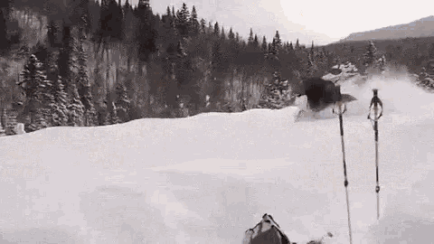
You’re saying there’s no appetite for you and me sharing pictures of thigh deep powder posing with a stray moose on an empty ski slope?
.
-
1
-
3
-
-
I better go buy shear pins tomorrow morning. I used my last ones with last weekend.
-
3
-
-
In the reverse jinx category, I am having my winter tires switched off of my daily driver on Monday (not my choice as a bent strut lead to two first-season Nokian snows getting 6" slashes in them since Wed night. Good times)
-
 3
3
-
-
39 minutes ago, dendrite said:
What did your area have in 1933?
a depressed economy
-
1
-
2
-
-
4 hours ago, mreaves said:
-
2 hours ago, MJO812 said:
Where is everyone ? New England is going to get hit with a huge snowstorm and no one posting.
We are out moose peeping. They are coming out to lick the salt from the side of the roads.
-
1
-
-
1 hour ago, Sey-Mour Snow said:
Lol well to be fair like 90% of News Englands population is in SNE. Edit just checked 79% of New Englands population is in SNE.
Except on the weekends. Is everyone in Mass required to leave the state boundaries on the weekends?
-
1
-
-
12 hours ago, Damage In Tolland said:
I need snow in the sumner ?
No you need Rain in the Summertime (it even has running lyrics):
-
1
-
-
5 minutes ago, CoastalWx said:
I’m only happy when it rains
-
3
-
-
51 minutes ago, kdxken said:
My new relative. A week old today . Told her we were getting more rain.

Nice to see she has the face palm down.
-
1
-
1
-
-
1 minute ago, powderfreak said:
That’s wild.
If you think that is wild, check out the 3k clown and this is only at hour 53!

-
3k N?AM tells Vermonters to go to the banks of the Connecticut and watch the snow accumulate on the other side of the river.
Quite the remarkable cutoff
Edit: I like the typo in NAM, I am going to leave it.

-
2
-
-
1 hour ago, kdxken said:
You're a bird guy right? Just heard a racket coming from a pine Grove near where I was cutting. The goldfinch are back in town. Lots of them...

-
1
-


Significant Miller B Nor'easter Apr 3rd-4th OBS
in New England
Posted
Its really heavy now. Up to 7." Power flickered once but still on.