

bjc0303
-
Posts
291 -
Joined
-
Last visited
Content Type
Profiles
Blogs
Forums
American Weather
Media Demo
Store
Gallery
Everything posted by bjc0303
-
Central/Western Medium-Long Range Discussion
bjc0303 replied to andyhb's topic in Central/Western States
12z ECMWF while somewhat north/west for Wednesday suggests a similar level of severe threat. Friday looks weird. CAA regime really ****s with cyclogenesis. -
Central/Western Medium-Long Range Discussion
bjc0303 replied to andyhb's topic in Central/Western States
A little earlier than I originally thought but 00z GFS depicts a *very* potent system impacting southern plains Weds afternoon/eve. Again - next week needs close watching.... -
Central/Western Medium-Long Range Discussion
bjc0303 replied to andyhb's topic in Central/Western States
European ensemble especially shifts the ridging east particularly near/after 240 per yesterday's 12z run, but in the meantime what looks like an early summer pattern looks to prevail. Somewhat concerning to see so early on but perhaps it's only a short term thing. 12z model suite edit: late next week needs to be watched closely. -
Central/Western Medium-Long Range Discussion
bjc0303 replied to andyhb's topic in Central/Western States
Does seem like a pretty quiet stretch ahead. Latest EPS does suggest an extended period of southwest flow aloft towards the latter portion of April. -
Central/Western Medium-Long Range Discussion
bjc0303 replied to andyhb's topic in Central/Western States
those cells are well elevated associated with DCVA. no chance of becoming sfc based -
Central/Western Medium-Long Range Discussion
bjc0303 replied to andyhb's topic in Central/Western States
You're going out for this? I probably will...perks of living near the typical dry line position.. -
Central/Western Medium-Long Range Discussion
bjc0303 replied to andyhb's topic in Central/Western States
Latest ECMWF shows what could be a 2-day event on Easter weekend in the high plains. Sunday looks most interesting to me with the arrival of a negatively tilted trough over the southern/central Rockies. ECMWF shows QPF suggesting supercells along the dry line (by 00z MON) from western KS down through the panhandles of TX/OK. Pros: a solid synoptic setup on Easter weekend Cons: Well, it is about 210 hours out... ECMWF also indicates jet extension over pacific that might lead to some western US troughing into late April and early May. Waiting to see what latest ensemble guidance suggests. Pattern looks to remain fairly progressive last I saw. -
Central/Western Medium-Long Range Discussion
bjc0303 replied to andyhb's topic in Central/Western States
notable trends on last few NAM runs: -westward shift of triple point and dry line. less veered sfc flow and a more N/S dry line -greater instability owing to both a slightly higher sfc moisture fcst and now lapse rates being forecasted to approach 9 (!) K/km. -while features shift west, low level jet hasn't really shifted so some lessening of low level shear has occurred. It's mixed among models so we will have to see how that evolves over time. Overall a decent early season event if you ask me, although I live near where the dry line will most likely set up. Tor potential looks non zero but still low, but should trends continue it could be okay. Interestingly, this looks like a left mover fcst by the 3 km. I don't think I've seen a left mover fcst by a CAM before, or not very often at least. Encouraging to see CI. -
Central/Western Medium-Long Range Discussion
bjc0303 replied to andyhb's topic in Central/Western States
Starting to seem that way, although NAM and GFS exhibited a slowing trend approaching event hour (especially the GFS) with some of the waves earlier in this season...... Maybe we'll luck out? Just about ready to wave the white flag and look down the line -
Central/Western Medium-Long Range Discussion
bjc0303 replied to andyhb's topic in Central/Western States
somewhat interesting to me looking down the line is the trend/stubbornness of SE ridge... we will probably see a brief lull in activity but thinking a return to active wx again may be faster than originally thought. -
Central/Western Medium-Long Range Discussion
bjc0303 replied to andyhb's topic in Central/Western States
I was mostly kidding. Agreed on GFS. Just odd to me that EPS and euro deterministic are trending to a deeper compact and negatively tilted wave while GFS holds its ground. -
Central/Western Medium-Long Range Discussion
bjc0303 replied to andyhb's topic in Central/Western States
Are we just going to ignore other guidance? 12z Euro seemed pretty favorable to me and its ensemble seems to back it up pretty well. No idea what individual members looked like.. GEFS still had considerable spread among members. They seem to be trending in opposing directions, haha. -
Central/Western Medium-Long Range Discussion
bjc0303 replied to andyhb's topic in Central/Western States
ECMWF and GFS are in no agreement whatsoever on placement. ECMWF solution lends to a more S/SW or S low level jet. typical of GFS being too progressive. ECMWF also has lee cyclogenesis as expected with its wave/height field whereas GFS just has broad low pressure associated with low amplitude wave/jet aloft. EPS shows pretty good signal and I have to say I think I side with the euro/EPS. If at any point the Euro or EPS begin to trend towards the GFS, I will be concerned. I think this is a case of the GFS being too progressive with smaller waves.. as we have seen several times this spring -
Central/Western Medium-Long Range Discussion
bjc0303 replied to andyhb's topic in Central/Western States
trend among the most recent 12z EPS 500 height + anomalies mean suggest a nice severe threat Sunday. Prominent east ridging will allow for quality moisture return. Solid EML advection likely as well leading to steepening lapse rates. Looking like a classic dry line setup.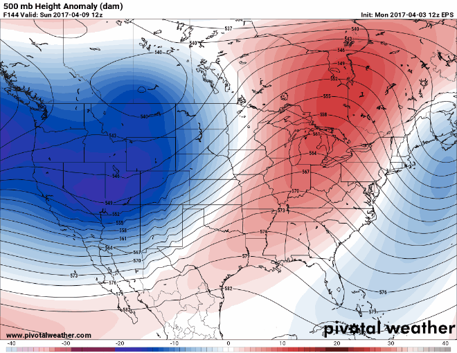
-
Central/Western Medium-Long Range Discussion
bjc0303 replied to andyhb's topic in Central/Western States
Euro continues to show a pretty nice dry line setup from SW OK into east kansas. CI looks to be an issue far southwest but ECMWF QPF suggests what would probably be discrete supercells along dry line from central OK into eastern KS. S/SE flow along the dry line currently forecast verbatim, veering to 40 knots S/SW at 850. Definitely one to watch. GFS is in relatively good agreement as well. Fcst soundings show widespread 0-1 SRH ~200 m2/s2, MLCAPE 2000-2500 range. -
Central/Western Medium-Long Range Discussion
bjc0303 replied to andyhb's topic in Central/Western States
GFS showed enough height falls/glancing influence of DCVA from the wave such that CI would be probable along the dry line. Anything less probably results in capping winning out.. You really need large scale ascent to destabilize the atmosphere. Sfc heating is rarely enough. -
Central/Western Medium-Long Range Discussion
bjc0303 replied to andyhb's topic in Central/Western States
Not really, they are pretty similar last I saw. However, capping looks to be an issue farther south. That's not to say CI won't happen.. The GFS was forecasting CI and so has the ECMWF. Given how far out it is they will likely expand in later outlooks, but better (or should I say more likely to be focused) large-scale ascent will be farther northeast. I'd expect it to expand in subsequent outlooks. -
Central/Western Medium-Long Range Discussion
bjc0303 replied to andyhb's topic in Central/Western States
00z ECMWF and last few ensemble runs show quite the pattern this weekend into next week. Think first big chase able setup may come from this one. moisture looks great on deterministic and pattern wise, with a southeast US ridge, the pattern looks great. Given gulf conditions.. a substantial moist layer may develop. Optimism is high. -
Central/Western Medium-Long Range Discussion
bjc0303 replied to andyhb's topic in Central/Western States
would be more encouraged if models weren't showing a washout of the gulf -
Central/Western Medium-Long Range Discussion
bjc0303 replied to andyhb's topic in Central/Western States
Well, I have been eyeing Tuesday for a pretty cool minute now and SPC just put out a day 3 enhanced. This one has been trending the right direction for just about everything. Looks to me like a potential tornado event for sure. -
Central/Western Medium-Long Range Discussion
bjc0303 replied to andyhb's topic in Central/Western States
As the GFS trends a little more to the Euro consider me pretty interested in Tuesday. Degree of moisture return will determine how big a day it could be. shear profiles look really nice as a whole on 06z GFS. ECMWF manages upper 50s/low 60s into the TX PH and west OK. Gonna need to watch that trend. If anything this general pattern will help bring some *much* needed rain to the area. Low soil moisture and intense mixing is causing severe underperformance as far as moisture goes, and we do not want that problem lingering later into April or May. -
Central/Western Medium-Long Range Discussion
bjc0303 replied to andyhb's topic in Central/Western States
Last night's euro has a decent looking high plains setup Tuesday. Would seem likely to me that supercells initiate on dry line and eventually grow upscale... model QPF seems to support this. -
Central/Western Medium-Long Range Discussion
bjc0303 replied to andyhb's topic in Central/Western States
And interestingly the newest GEFS and EPS show more negative height anomalies in the west/desert southwest towards the end of the cycle...so no real end in sight. Courtesy of yet another NPJ extension. Is there any reason this might make for a quiet late April or may? I see people mention this but never based on any logic other than how active it is now. -
Central/Western Medium-Long Range Discussion
bjc0303 replied to andyhb's topic in Central/Western States
Yeah, with the quick progression and development I wouldn't anticipate significant mixing. As it was progged 00/06z, reminded me of May 10 2010 in the loosest way possible (rapid changes, fast compact shortwave) although the shear and instability do not compare. I would have to agree that the next series of waves, pending any significant changes to the forecast output, nothing screams anything significant to me. But the Gulf looks like it'll be good by midweek should things pan out with a particular wave. 70s dewpoints forecast across the gulf, yes please -
Central/Western Medium-Long Range Discussion
bjc0303 replied to andyhb's topic in Central/Western States
I guess we will see. If it doesn't pan out, the gulf looks to become wide open for future systems shortly after with 70S Tds progged throughout the Gulf, unperturbed, by early/midweek. I will say that something of concern down here is the tendency for GFS and NAM to pretty substantially underforecast surface mixing. Could be offset by minor cloud cover and some greening or really strong moist advection but it could become a problem. Of course at the same time moisture for Sunday has really trended up in the last few runs so we will see
