bjc0303
-
Posts
291 -
Joined
-
Last visited
Content Type
Profiles
Blogs
Forums
American Weather
Media Demo
Store
Gallery
Everything posted by bjc0303
-
Central/Western Medium-Long Range Discussion
bjc0303 replied to andyhb's topic in Central/Western States
For sure. I definitely think an event happens, just would love to see us maximize our potential for once lol. -
Central/Western Medium-Long Range Discussion
bjc0303 replied to andyhb's topic in Central/Western States
Which is my biggest concern. Time of year says amplification is a big worry. 12z euro while still impressive did not have the best overlap between instability and shear. If we can get it worked out, would be a pretty nice event I’d think. Shear vectors would favor discrete mode as progged by both GFS and ECMWF. Low level shear looks very impressive, so here’s to hoping it all lines up. -
Central/Western Medium-Long Range Discussion
bjc0303 replied to andyhb's topic in Central/Western States
Day 7 outlook and I can’t say I’m surprised at all. The general threat area has been highlighted well by most guidance. Considering GFS likely underforecasting instability, forecast wind fields on the GFS/ECMWF look pretty impressive..by 21z. Going to be one to keep an eye on. -
Central/Western Medium-Long Range Discussion
bjc0303 replied to andyhb's topic in Central/Western States
Well, I am pretty intrigued in the Thurs/Fri timeframe for a severe weather event over the high plains. Big differences between ECMWF and GFS ensembles.. but worth keeping an eye on. Won't bother posting deterministic guidance from GFS with apparent differences between both models, but if that verified I'd be out there no question. -
Central/Western Medium-Long Range Discussion
bjc0303 replied to andyhb's topic in Central/Western States
Hard to write off tornado potential for Friday. Personally I have seen this song and dance in recent time and expect this to shift west such that CI along the dry line very well could end up along I-35 rather than on the border of the TSA region. I do think OK sees first tor of the season Friday, but that will hinge on wind profiles aloft. Subtle changes in the flow, nothing which is impossible at this range, could enhance tornado potential in the mesoscale. Won't be chasing this one, but will be forecasting/nowcasting for it and enjoying the view. -
Central/Western Medium-Long Range Discussion
bjc0303 replied to andyhb's topic in Central/Western States
Boy the 12z euro pretty much annilhates the gulf. Meanwhile the EPS shows several western troughs passing through afterward. Man am I tired of these garbage April years. Used to be you could actually get tornadoes in April -
Central/Western Medium-Long Range Discussion
bjc0303 replied to andyhb's topic in Central/Western States
Forecast graphics to accompany the above:
-
Central/Western Medium-Long Range Discussion
bjc0303 replied to andyhb's topic in Central/Western States
Operational 12z Euro looks like a pretty nice event over OK, KS, and adjacent areas. This in large part to a potent vort max on the southern periphery of the larger central US trough. As a result of the approaching vort max, consolidated pressure falls in OK lead to backed winds along the entirety of the dry line. This configuration with enhanced downward momentum transport on the dry side of the dry line, and enhanced lift, would probably lead to a mesolow/dry line bulge configuration over OK. Combined with strong height falls, the ECMWF initiates convection/QPF in a signal that suggests scattered convection along the dry line from OK into KS, likely supercellular. This run certainly presents its most potent threat yet across the I-35 corridor and areas east, with strong S LLJ and strong SW winds aloft. Perhaps backing aloft, which could prove to be a mitigating factor with time regarding storm mode. All of this is of course perfect progging the 12z ECMWF. -
Central/Western Medium-Long Range Discussion
bjc0303 replied to andyhb's topic in Central/Western States
Just took a look into the 00z ECMWF op.. Gotta say if you speed the progression of the euro up by ~6 hour or so.. You're probably looking at a rather robust severe weather event over the plains. -
Central/Western Medium-Long Range Discussion
bjc0303 replied to andyhb's topic in Central/Western States
Lots will change - but the way the GFS has shifted ridge axis about 100 miles east is allowing for pretty impressive moisture return forecast next week, with return flow undisturbed. Scenario would suggest upper 60s dewpoints within reach, especially with anomalous gulf water temps we’ve seen in recent years. Plenty can change - that lead wave with a few changes could amplify to hell and send all of our moisture back into the gulf. However ensembles expand the ridge in the east which should mitigate any opportunities for the lead wave to blow up on us. So low-mid 60s just chill, capped under a stout EML, in the RR area waiting for the arrival of the next system. The euro and CMC show a similar evolution but show a storm track that could leave the plains out of it. Most of all I’m a fan of the ensemble consensus for perhaps a persistent east coast ridge. -
Central/Western Medium-Long Range Discussion
bjc0303 replied to andyhb's topic in Central/Western States
Agreed, but (though, extended range) spacing looks pretty solid on GFS/Euro...for now -
Central/Western Medium-Long Range Discussion
bjc0303 replied to andyhb's topic in Central/Western States
Am a fan of the euro/EPS mean for mid-late next week. -
Central/Western Medium-Long Range Discussion
bjc0303 replied to andyhb's topic in Central/Western States
It seems like a near certainty as described by several others that the first week or two of April will be quite dull. Anything after that - even considering the euro weeklies - is probably a crapshoot. Hope is that activity begins picking up April 15th and onward. -
Central/Western Medium-Long Range Discussion
bjc0303 replied to andyhb's topic in Central/Western States
Euro has trended towards a pretty decent severe threat on Monday I would imagine. Surface winds go from SE to S/SSE at 850 to SW aloft. The euro has exhibited quite a trend in SW flow, what used to be SSW @ 500 has trended to SW. The euro also seems to have dialed back on widespread QPF, potentially allowing greater instability to develop and better storm organization to take place. With the change in modeled wind fields, deep layer shear vectors now exhibit a large component orthogonal to the dry line, suggesting a better opportunity to remain discrete. -
Central/Western Medium-Long Range Discussion
bjc0303 replied to andyhb's topic in Central/Western States
Perhaps. 12z Euro keeps precip in the picture but as you said, it’s confined to the east. The euro does destabilize the dry line quite a bit, and has a solid shear profile. Would be potential for supercells I imagine, but the effects of mid morning precipitation still has me concerned. Hopefully the NAM can bring clarity. Doubting the lead wave just disappears at this range of modeling, but maybe we can get more favorable timing. -
Central/Western Medium-Long Range Discussion
bjc0303 replied to andyhb's topic in Central/Western States
Although the trends are encouraging one thing to watch is early/midday convection. Looks like a lead impulse is leading to pretty widespread convection/rainfall over the central OK warm sector by morning/midday which would put a huge dent in potential for Sunday. Obviously things can and will probably change but as we enter realm of better predictability, this is a growing concern. -
Central/Western Medium-Long Range Discussion
bjc0303 replied to andyhb's topic in Central/Western States
00z euro has taken a dramatic step towards the GFS in my opinion. Similar boundary/low placement and everything for Sunday. GFS ensemble is really locking in on Sunday and with Euro agreement I’d say there’s a chance at a broad 15% day 5 for west OK. Euro slightly less on moisture but looks to be higher on 0-1 km bulk shear and instability which is the most interesting bit Edit: I’d have to analyze the ECMWF ensemble before making a definitive statement there. -
Central/Western Medium-Long Range Discussion
bjc0303 replied to andyhb's topic in Central/Western States
I’ve heard that the effects of the SSW could last until late April. -
Central/Western Medium-Long Range Discussion
bjc0303 replied to andyhb's topic in Central/Western States
Unfortunately I am most confident in that massive northeastern ridging, given model forecasts and the continuing effects of the Feb SSW. But even so, the GFS and its ensemble do paint an elevated severe risk day. I can’t help but be in love with the GFS ensemble mean for Sunday. The Euro is a different story. We will see - I am not confident the GFS will win here, but I do like the look of the ensemble mean.
-
Central/Western Medium-Long Range Discussion
bjc0303 replied to andyhb's topic in Central/Western States
Yeah, the evolution of the wave has degraded significantly and the moisture return and associated surface evolution just looks like... uh.. garbage. The numerous vorticity maxima weakening return flow big time. -
Central/Western Medium-Long Range Discussion
bjc0303 replied to andyhb's topic in Central/Western States
Patterns don’t get used up. An active march pattern says nothing of what April and May will bring. Could be a year where the base state is active, or reverse. -
Central/Western Medium-Long Range Discussion
bjc0303 replied to andyhb's topic in Central/Western States
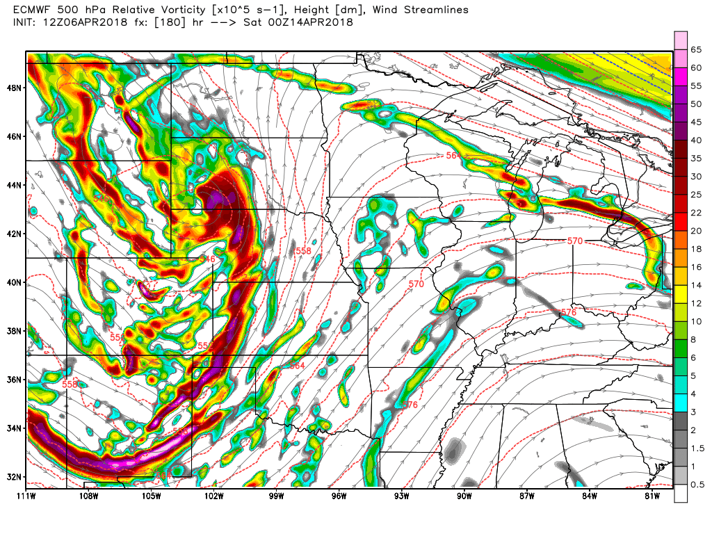
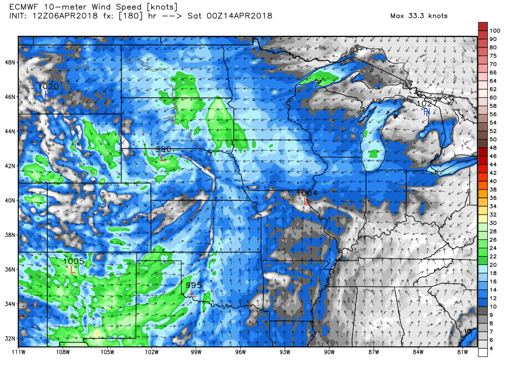
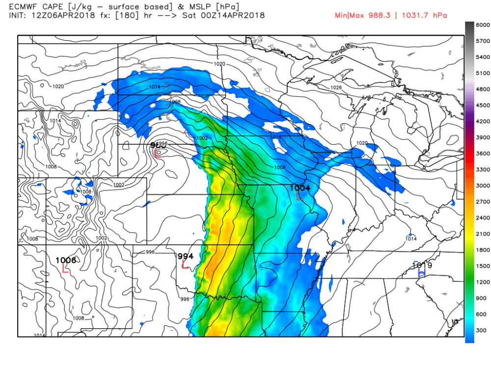
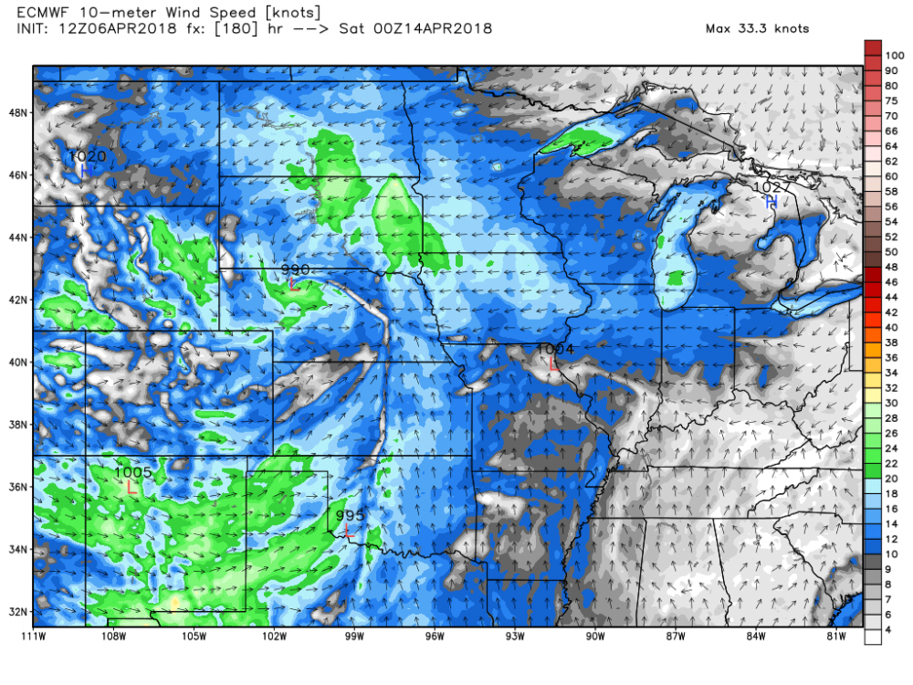
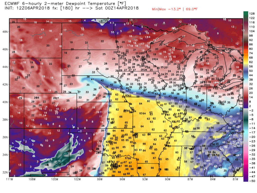
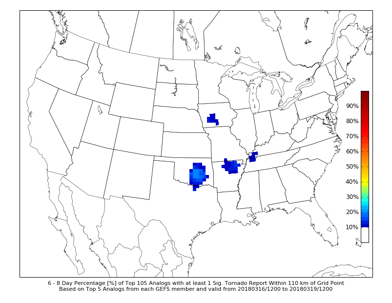
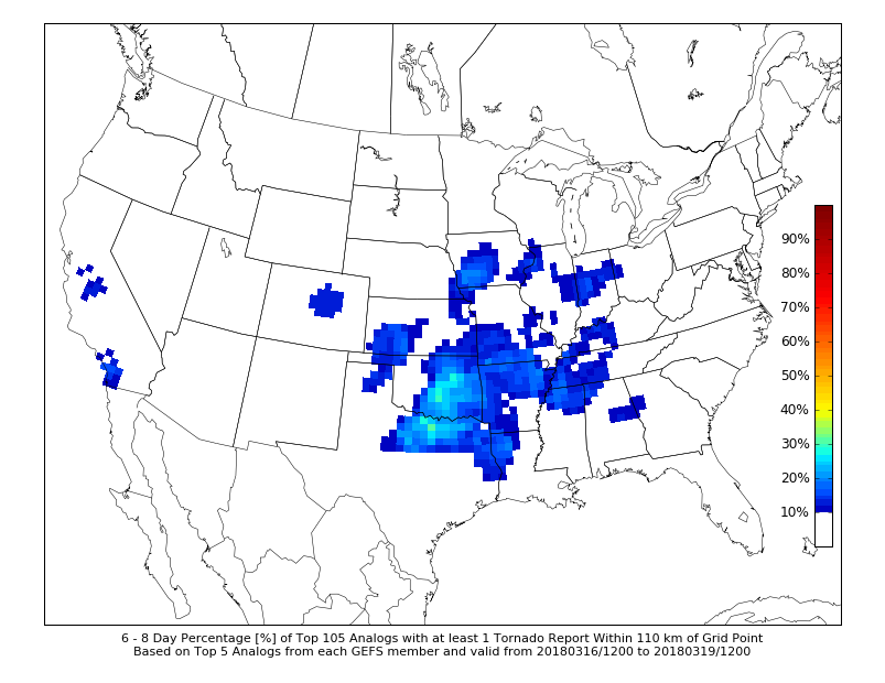
Pretty impressive agreement between ECMWF, CMC, and GFS. Differ on amplitude and timing, but the general consensus shows a severe weather event over the same general area for Sunday. Impressive for a week out. Not sure who is more potent: the GFS or the ECMWF. GFS more unstable, ECMWF by far the stronger between the two wrt shear profiles. 70 knot deep layer shear and 35-45 knot 0-1km shear on the ECMWF. Definitely one to watch, and one that has some synoptic backing for sure. Would think the dry line sets up along I-35 if things hold, but with how strong the synoptics are it could push near Tulsa. Seems to me that this is a pattern offering higher predictability. It doesn't seem like there is much to offer in terms of downstream/eastern amplification. The GEFS 6-8 day analogue forecast: At least 10 Svr reports At least 1 tornado At least 1 sig tor. Seems to me that models should have a good handle on this one.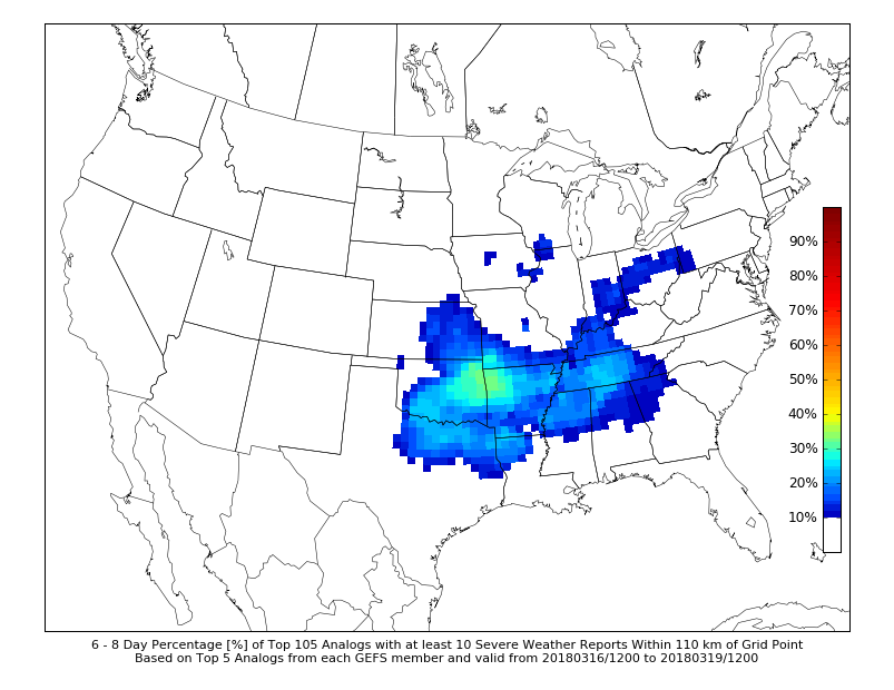
-
Central/Western Medium-Long Range Discussion
bjc0303 replied to andyhb's topic in Central/Western States
GFS certainly coming in more potent. It slows down the progression of the pattern and amplifies the upper level trough as it ejects, which is leading to these really strong low systems. Interesting development. -
Central/Western Medium-Long Range Discussion
bjc0303 replied to andyhb's topic in Central/Western States
GFS continues to advertise big time pattern shift, with significant shortwave traversing plains in the 8-10 day range. This coincides with some teleconnection/GWO phase space forecasts. With several days of return flow (even though prior cold front pretty significant), we could see a bit of an active stretch coming up. -
Central/Western Medium-Long Range Discussion
bjc0303 replied to andyhb's topic in Central/Western States
Operational GFS and CFS ensemble appear to suggest a looming pattern change in the 7-14 day window coinciding with the latest ERTAF week 3 forecast of AA tornado activity. Could be plains first decent period.