

SnowLover22
-
Posts
1,300 -
Joined
-
Last visited
Content Type
Profiles
Blogs
Forums
American Weather
Media Demo
Store
Gallery
Posts posted by SnowLover22
-
-
2 hours ago, WxWatcher007 said:
College study abroad? Does it snow there?


Averages 77mm of snow. And yes studying abroad. Also, If I can, I will try to be there the whole year. Depends if I can get an internship and extend my visa.
-
 2
2
-
-
4 hours ago, Stormfly said:
Some impressive boomers last night over northern PA.
I thought I had State College site selected in Radarscope. Nope! When they show up like that (so far from the nexrad site) you have some serious height!
It is a shame radarscope does not work in Germany. I am studying there for 4 months and trying to figure out a good radar website lol.
-
1
-
-
9 hours ago, Windspeed said:
Larry's forward motion appears to be slowing. I suppose we're going to find out just how much shallow TCHP can support a 'cane this large. Another EWRC is underway. But Larry is not in any hurry to the NW on its current heading at the moment. Granted there is still plenty of deeper OHC to the northwest. Really at this point it's just a visual experiment on if Larry can maintain enough thermodynamic driven convection to fuel the even larger eyewall that is forming. There is a rather large region of 29°C SSTs northwest on its current heading. Should be enough to keep it a major hurricane through Thursday.

Correct me if I am wrong but generally the larger the eye, the more stable the eye is and less susceptible it is to eye-wall replacement cycles. Fun fact btw, the largest eye ever recorded was around 230 miles across.
-
1
-
-
This is really cool, NHC podcast on Ida
-
2 minutes ago, SnowLover22 said:
maybe this depicts the maximum theoretical strength that the hurricane could get based off of ocean temps but idk...

obviously not realistic but..... still funny to look at
the same model also shows 200 knot winds or 230 mph at 850mb.
-
maybe this depicts the maximum theoretical strength that the hurricane could get based off of ocean temps but idk...
-
1 hour ago, BuffaloWeather said:
New map

6-8 inches is the forecast and not even an advisory. Has to be a joke right?
-
Lets end the winter with a bang.... why not
-
2 minutes ago, lakeeffectkid383 said:
Just had some thunder snow at my job north of Strykersville!
first time this winter!
I was just gonna ask if anyone heard thunder. Thanks for the confirmation!!!!
-
Because why not...
this will lock in for sure....
-
I will start next weeks storm thread.... the day of the storm..... no need for any bad luck....
-
1
-
 4
4
-
-
On 2/15/2021 at 6:48 PM, SnowLover22 said:
I'm honestly more worried about storm #2 missing to the south than to the north. Now that would suck. Getting storm #1 to miss to the north only to get storm #2 to miss to the south.
Goddammit.....
Why did I speak this into existence
-
LMAO thought this was funny.
-
1
-
-
2 minutes ago, TugHillMatt said:
Ehhh..just plop it in top of a snow pile.
")
at least the 3 inches of ***** on top of the existing snow pack acts as a protector to preserve our pack.
-
1
-
-
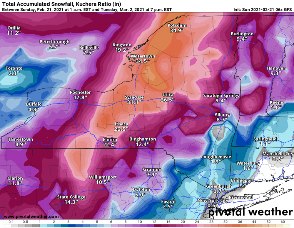
8 hours ago, SnowLover22 said:
Final Call
Rochester:
10"8"3"Syracuse:
7"2"Binghamton:
3.40" ice accretionGeneva:
4-5 inches3inchesBuffalo:
14 inches6 inches (most likely jackpot)Fixed***
-
1
-
-
Okay just changed to all sleet. 5-6 hours ahead of schedule. My 2-4 inch call is looking great.
-
3 minutes ago, CNY_WX said:
Penn Yan just went over to sleet.
That observation is inaccurate. I am south of Penn Yan and snow and sleet mixed. 80% snow still.
Edit: Ignore I am north of Penn Yan makes sense.
-
3 minutes ago, rochesterdave said:
Have you changed over?
CC map says I have but ground observations tell a different tale. hanging on to snow for dear life.
-
1 minute ago, TugHillMatt said:
Beautiful Jebwalk completed..and I'm alive.
") Granular sugar just pouring out of the skies. Not large dendrites, but it's coming down so heavy it's adding up. 25 minutes of pure bliss...not worrying about the sleet probably to come. Will reach 3 inches within the hour. Standard synoptic snowfall for this winter season.
Granular sugar just pouring out of the skies. Not large dendrites, but it's coming down so heavy it's adding up. 25 minutes of pure bliss...not worrying about the sleet probably to come. Will reach 3 inches within the hour. Standard synoptic snowfall for this winter season.
Did you feel the snow in your bare hands. It literally feels like sugar.... same texture
-
1
-
-
well looks like 2 inches in Geneva will be the final total for snow. Just about to change over the sleet now. Should hit Rochester within the next hour or 2. Wayyyy ahead of schedule.
-
1 minute ago, BuffaloWeather said:
All sleet here now. That was quick lol
unbelievable. No models had you getting sleet.
-
Is Elmira really already reporting freezing rain? I am only 1 hour 15 min north. Oh well....
-
I'm honestly more worried about storm #2 missing to the south than to the north. Now that would suck. Getting storm #1 to miss to the north only to get storm #2 to miss to the south.
-
Just now, 96blizz said:
RGEM almost has zero mixing to here in skaneateles. Closest it gets.

the craziest thing about this is just a few days ago it was looking like Philly-NYC was going to get a major ice storm. Now they seem to be getting mostly just plain rain.


Major Hurricane Sam
in Tropical Headquarters
Posted
It very well could have been a cat 5 and we might never know, lets see what recon has to say.