

DownpourDave
-
Posts
1,341 -
Joined
-
Last visited
Content Type
Profiles
Blogs
Forums
American Weather
Media Demo
Store
Gallery
Posts posted by DownpourDave
-
-
1 minute ago, WinterWxLuvr said:
Huge jump. And the changes at h5 were fun to watch. Hold it back just a tad and sharpen it just a touch and you’ve got a big storm
Verbatim DC on south would've seen decent snows this run. I liked the way the PVA was orientated.
-
4 minutes ago, DDweatherman said:
We've seen that one before... so don't rule it out.
out to 9 hours euro looks more similar to 0z than 6z FWIW.
-
4 minutes ago, Ji said:
indeed. it never really started. We all knew the EPS/Euro was bunk but we were hoping for a miracle
what if the euro actually trends more amped? It would be almost comical at this point.
-
 1
1
-
 1
1
-
-
2 minutes ago, DDweatherman said:
You all can crucify me later for waving the white flag. Weather isn’t just models and you know that as well. Our base state and the speed of the flow argues against a Euro like solution and phase. 18z last night was it’s peak there with amping our wave. Happy to eat my words if needed but under normal circumstances we’d be ready to call this one.
Time of Death: 1:05 PM
kidding but not kidding
but seriously...
I won't know what to think if the euro holds serve still.
-
4 minutes ago, stormtracker said:

You win some, you lose some. I have no shame in that. Credit to where it is due. I'll take the L and one that I am happy to take
-
1
-
-
2 minutes ago, stormtracker said:
huh? you got the GFS that far out already? Who said anything about a cave?
I got the sense people were hoping the gfs would move more toward the euro than it did but your right no one said such thing. There are improvements on the gfs at h5 which is a positive.
-
1 minute ago, stormtracker said:
can already see some improvements on the GFS. Let's see if she holds
improvements yes but not a cave....
id feel a lot better if the gfs moved to the euro faster.....
-
4 minutes ago, Ji said:
The euro and ensembles are going to fail. We all know it
Well.... the gfs won't be caving to the euro tonight. Euro up next.... something has to give.... I wonder which model blinks first?
-
1
-
-
2 minutes ago, Ravens94 said:
Icon appears to be better then 18z
Don't believe it... it is Iconning us!
")
-
 3
3
-
-
now if the 18z euro can hold the line or even trend better lol.
-
Just now, snowfan said:
Share notes and let us know the outcome.
Never said it looked better or worse. Just said it looks nothing like the euro.
-
lets just say the gfs won't get it done this run. The changes are laughable at h5 vs the 12z euro. They are worlds apart.
-
uh oh....
Seriously you would think it would not just impact the euro though.
-
2
-
-
Just now, WinterWxLuvr said:
They are 33-50% greater than pivotal
???
no they aren't.
-
5
-
-
2 minutes ago, stormtracker said:
Did you hear? Betty White died
your timing is impeccable lol. Today would've been her 100th birthday.
-
1
-
-
8 minutes ago, NorthArlington101 said:
Has a weekend storm but it’s suppressed and on the Carolina coastline this run. Okay with me.
would not take too much of an adjustment at range. Verbatim goes negative too late by a little bit.
-
1
-
-
1 minute ago, Bob Chill said:
The potential next weekend reminds me an awful lot of how we got multiple ok storms in JF 2014. A few of those strong waves running boundaries were modeled ok pretty far in advance. The progressive nature of the flow will jump things around by default but we're seeing a little bit of consistency show up 6 days out. Today's storm was well modeled that far in advance. We'll see
as I said before key thing to look out for is what happens out west. The energy does not cut off, it phases with the northern stream ala CMC and Euro.
-
2 minutes ago, stormtracker said:
What time frame are you talking? Because comparing the NAM to the other models that have the storm, there's no way to tell if the baja low is gonna cut off yet at that time frame. I could be looking at the wrong thing too.
compare h5 84 hours gfs to h5 84 hours NAM. Then see what happens on the gfs. You can surmise the nam was heading in the same direction.
-
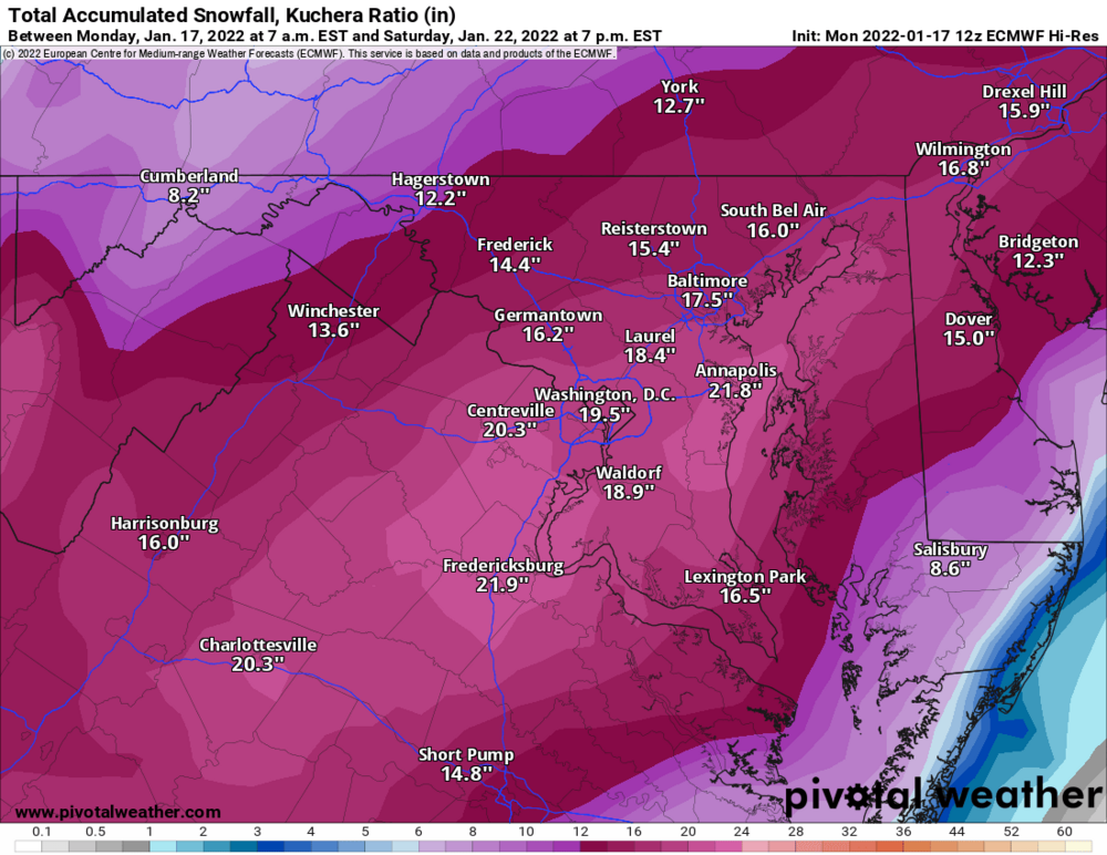
IMO, figuring out what happens near Baja California is key. The 6z gfs is a miss because it cuts off and leaves energy behind there. FWIW, the 12z NAM would've been a miss as well. Leaves energy behind. The 6z euro would have been good most likely. Very similar to 0z does not leave energy behind at 90 hours. Only 84-90 hours out to figuring it out. Something has to give!
-
Hopefully im not the only person still awake...
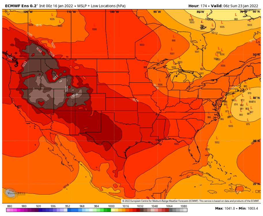
EPS
-
6
-
-
close up
-
2
-
 1
1
-
8
-
-
Just now, leesburg 04 said:
We've been feeling that in every one of your posts
the screen name checks out.
-
1
-
-
39 minutes ago, BuffaloWeather said:
I bought a new ariens last year that I love. Haven't started it yet this year. If it looks like a decent event I'll have to start her up. Things a beast
I was in Hamburg just recently.... Hamburg, Germany that is
-
1 minute ago, BGM Blizzard said:
Looks close to the GFS. WNY gonna get the best this run.
.thumb.png.89140f223639362008f9458b3b1013ba.png)
Damn I might need to drive up on Sunday. Original plan was to be in Upstate by next Friday. At the very least should be a solid snowpack by the time I get there on Friday after the storm (assuming nothing changes)


.png.cb579ad4e737e203f706a6e91b1058e9.png)
Mid to Long Range Discussion ~ 2022
in Southeastern States
Posted
For shits and giggles for you guys.