

JoMo
-
Posts
8,985 -
Joined
Content Type
Profiles
Blogs
Forums
American Weather
Media Demo
Store
Gallery
Posts posted by JoMo
-
-
49 minutes ago, The Waterboy said:
Finally, I almost hate to ask the question but I will anyway. Was that the end of winter or do we see one last chance for more before mid-March?I look at it like it's the last time since it's so late in the season. Anything else is just bonus. Haven't really looked into things a month off though.
-
Interesting:
QuoteSpecial Weather Statement National Weather Service Little Rock AR 242 PM CST Wed Feb 17 2021 ARZ054>057-062>065-069-172215- Hot Spring-Grant-Drew-Cleveland-Lincoln-Desha-Arkansas-Dallas-Jefferson- 242 PM CST Wed Feb 17 2021 ...A SEVERE SNOW SQUALL WILL AFFECT CLEVELAND...NORTHWESTERN DESHA... SOUTHERN GRANT...DALLAS...NORTHEASTERN DREW...SOUTHERN JEFFERSON... LINCOLN...SOUTHEASTERN HOT SPRING AND SOUTHWESTERN ARKANSAS COUNTIES... At 238 PM CST, a severe snow squall was located in a region from Malvern to Sheridan to Pine Bluff to Star City to Fordyceto western Dallas County. . This area of intense snowfall was moving east at 30 mph. Locations impacted include... Pine Bluff, Dumas, Sheridan, Fordyce, Star City, Rison, Rohwer, White Hall, Gould, Leola, Grady, Kingsland, Sparkman, Mitchellville, Carthage, Watson, Winchester, Whitefield, Jenkins Ferry State Park and Little Bayou Meto Park. This includes Interstate 530 between mile markers 31 and 46. Visibilities will drop quickly to near zero in this severe squall. Conditions can deteriorate rapidly in winter weather situations. If you don`t have to be out on the roads in this area...stay put or stay home. Snowfall rates of 2 inches per hour or above are making conditions nearly impossible to drive in. These conditions are expected to persist through at least 4 PM.
-
 1
1
-
 1
1
-
-
It's 20 and it actually feels "warm" outside.
-
4
-
-
Had a band of moderate snow move through here as well, beautiful big flakes coming straight down. Didn't last long though.
Thundersnow, a 6"+ storm is all that pretty much exists on my winter checklist. If it doesn't happen, then this was a pretty amazing winter regardless with snow before Christmas, record cold, and a couple decent snow storms.
-
2
-
-
This was a wetter snow, it's caked to all the trees and cars. Probably an additional 3-4" fell here, maybe a bit more.
-
3
-
-
21 minutes ago, StormChazer said:
Show is about to start here in Owasso.
What's it like?
-
31 minutes ago, JasonOH said:
I’m now around 30 hours without power. This has been absurdly mismanaged by ONCOR seeing as their “rolling outages” haven’t been rolling at all.
Yeah, some areas in Joplin's "rolling outage" were supposed to be out only 1-1.5 hours, but for some reason it's been 3 hours and still no power there.
-
13 minutes ago, MUWX said:
It seems that rolling blackouts have returned this morning
Yep, Joplin is having them now.
-
Down to -8 here. Crazy cold.
-
13 minutes ago, rockchalk83 said:
I’m puzzled by the discrepancy. My guess is that the NAM has a deeper wave, the GFS has a flatter solution.
That's pretty much correct. The NAM is more negative tilted with the wave vs the flatter GFS. At hour 30, check out the 700/850 MB winds on the NAM vs the GFS.
-
1
-
-
Liberty Utilities is also doing rolling blackouts. Springfield NWS says Joplin got 4" but I don't know about that. Somewhere between 4-7" has been reported. Also they are going with additional snow of 2-6" Tues night (most being their S and SE counties)
-
So the Tues-Thurs or so storm is more difficult to discern. The initial round on Tues/Tues night is pretty clear cut but after that, it gets confusing due to differing model solutions on how the trough forms or behaves. The farther south and east you go, the greater the amounts is pretty clear. I think the NAM is probably the farthest northwest so far in this morning's model runs.
-
11 minutes ago, Wx 24/7 said:
Kuchera overdid it. I would look at QPF outputs and do a small multiplier. Seems like most snow ratios weren't off the charts like we thought they might be. Even then the next system looks significant.
The Wxbell Kuchera maps are obviously flawed. It wouldn't surprise me if it was purposely done in order to get people to post them to advertise or drive business to their site. Wichita was reporting 20:1 ratios yesterday.
-
54 minutes ago, The Waterboy said:
Onto the next storm. As JoMo (or someone) mentioned yesterday the NAM and RAP seemed to handle this best. The HRRR not so much. We’ll see what round 2 (or is it round 4?) says.
Yeah, the NAM did a great job (rare). It showed the 3 waves of precip on the 12z yesterday that eventually happened. The HRRR did very poorly.
-
I would just guess (it's too cold) that we have somewhere between 5-7" out there now.
-
1
-
-
Quote
Band of moderate snow extending generally along and southeast of
I-44 at present. This will continue to shift more toward the east
with time tonight. Snowfall rates of about 0.75" per hour have
been the norm within this band with 3-4" totals common around the
Tulsa metro, and as much as 6" reported near Ada. Expect similar
results through early tonight as the primary forcing shifts over
far eastern OK into western AR. Some changes have been made to the
going snowfall forecast but the overall message remains about the
same. Outside of this heavier band will likely continue to see
periods of light snow with broad areas of ascent east of the upper
trough moving through the Texas panhandle now.
Tulsa update.
-
2
-
-
5 minutes ago, Doramo said:
Not to much snow here...close to one inch . Looks like we struck out on the best chance for a good un .
Tomorrow for you. Couple inches tonight, couple tomorrow.
-
3
-
-
The 23z hrrr looks a lot like the 12z NAM today with the 3 waves of precip.
-
There's the Winter Storm Warning upgrade from Springfield.
-
2
-
-
9 minutes ago, MoWeatherguy said:
JoMo, how much have you gotten so far?
Probably around 1-2". Big band moving in before long.
-
The latest RAP has the snow band across Joplin while the HRRR misses it. The HRRR really hasn't done that great of a job today, has it?
-
Just now, garfan said:
I know many of the electric companies are experiencing a high demand for electric due to the cold spell.
Here is one example from the electric coop in SW MO that serves Newton County, McDonald County, and southern portions of Jasper County.
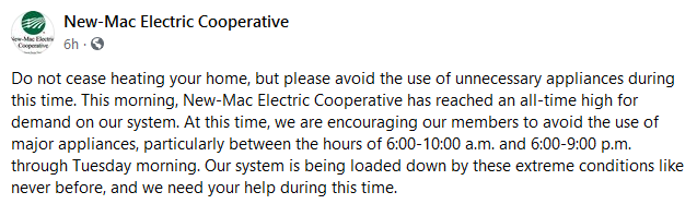
PEAK ALERT! But only in the winter, instead of the summer heat.
-
1
-
-
Tulsa is about to get the heavier band of snow. Anyone from down that way around?
-
4 minutes ago, MUWX said:
Regardless of what is going on with surrounding forecast areas, I think the current SGF forecast warrants an upgrade. I would guess people under the band from Joplin towards Columbia end up with several areas over 6”.
Yeah, that band of snow is strange. It's currently snowing the hardest it's snowed all day right now. I'm not sure if it's tied to some kind of front or exactly what the deal is. I thought the 850MB front is farther south into NW AR, so I'm not sure what's forcing the band.
MO/KS/AR/OK 2020-2021 "Winter" Discussion
in Central/Western States
Posted
That's pretty amazing compared to what the seasonal models showed and many professional forecasts. Guess we're still pretty clueless weather wise when it comes to forecasting things months in advance.