

Grayman
-
Posts
430 -
Joined
-
Last visited
Content Type
Profiles
Blogs
Forums
American Weather
Media Demo
Store
Gallery
Posts posted by Grayman
-
-
51 minutes ago, jjwxman said:
Lights out for me 15 miles south of GSO. Anyone have access to the Euro freezing rain accumulation maps?
I’m about 50 miles south of GSO so not that far. Cold rain here but at least it’s something to watch
-
21 minutes ago, wncsnow said:
Best run of the winter for MBY and puts a lot of NC in the game
.thumb.png.2f8741d681da533a3726c565ea8965d0.png)
Yes indeed. Too bad I get left out again. That storm is how it’s supposed to play out in NC.
-
4 minutes ago, BornAgain13 said:
So what are we to believe ? The GFS or the NAM. The NAM isn't much but all of a sudden the GFS is smoking us.
Who knows at this point. Starring watching HRR later today
-
4 minutes ago, HKY1894 said:
Big hit on 0z Euro for western NC
Next week?
-
4 minutes ago, wncsnow said:
BTW, the Canadian shows a nice CAD event Sunday
That would be lights out in the Piedmont
-
RGEM comes in ugly. Dumpster fire
-
1 minute ago, PackGrad05 said:
The 18Z GFS was trying to show something for Feb. 7. Low off the coast and high pressure in a somewhat favorable position, but weak 1030
I saw that. I think the storyline for this winter will be we can’t get the cold in our area. I think Western NC and mountains might score but I’m sticking a fork in winter( at least until I see my next weenie run) lol
-
30 minutes ago, kvegas-wx said:
Yeah, I just saw what @Grayman posted regarding the NAM temp forecast. I agree this is a plausible scenario. I'm just not buying it this go round. This has 35 and rain written all over it. Even during the Jan 8th event we ended up 2-3 degrees above forecast here in the triad and only for a brief moment did rates overcome temps. And I think the NAM was off on that one within 24 hours as well, assuming my memory serves me correctly.
This one has been over for me since Friday. They said air mass is way to warm to support big snow but those northern areas could see a brief period of snow As precipitation ends. I was afraid of a weenie attack if I posted that . Lol
-
1 hour ago, BullCityWx said:
The 3k NAM has 42 degrees for Durham 18z Wednesday. The GFS has us at 58.
The mentioned this is Raleigh forecast discussion about the temps. Said they were using NAm for Tuesday temps
-
45 minutes ago, CaryWx said:
The MJO not going there until Feb 15th earliest. I read. That's getting close to winter overtime around here
I wish I understood more about the MJO and how to track it etc. I really am just lost about this subject. I read up on it and still just don’t understand. Maybe someone knowledgeable could educate . Do you know what else would be cool? When we have a legit threat we do like a zoom call and discuss. We wouldn’t have many calls lol .
-
 1
1
-
-
14 minutes ago, chris624wx said:
Yeah, 12z Euro and 18z GFS have been somewhat discouraging but 18z NAM was decent so???? Hopefully we'll have a better understanding by 12z/0z tomorrow.
I’m pulling for you Virginia folks. I think it will be clearer by Monday pm
-
Just now, magpiemaniac said:
You’re right. It’s Tuesday’s highs warmed up a little compared to yesterday’s NAM runs, but its colder than the other models for this system. The NAM is asking us to not give up just yet.
I can’t help but chuckle because if I lived in N NC I would be doing the same thing. I love model hugging . Down my way the cut us off early . Lol . Good luck to those close to VA border
-
1
-
-
1 minute ago, NorthHillsWx said:
Euro was a dumpster fire for everyone
Awful . See you guys in early Feb to track out next 14 day event . I’m down
-
2
-
 1
1
-
-
It’s been over for Southen NC and most of central NC. Nail bitting time for SVA. Northeastern NC might do well.
-
1 minute ago, TARHEELPROGRAMMER88 said:
Any snowfall maps from GFS Para?
Here you go

-
 1
1
-
-
11 minutes ago, griteater said:
It still being 5 days out at least makes this a bit entertaining to watch how it unfolds in the end. Noticed on the UKMet that the closed low over the Great Lakes is farther south compared to the GFS....so there's a bit of squashing effect there with the height pattern along the east coast. Best bet is to probably just put all the models in a blender right now and take the average.
Grit, do you agree most 00 models tonight trended well for N NC?
-
2 minutes ago, wncsnow said:
We may as well be hopeful since there looks to be our last good shot for a long while
But 00z runs pushed snow right on all models minus Gfs. HP a little stronger each run
-
2 minutes ago, wncsnow said:
That UK runs tells me the Euro may be decent for GSO to Roanoke Rapids
I know we’re probably out of the game. But The 00 runs have really trended out way. I’m still learning but you agree?
-
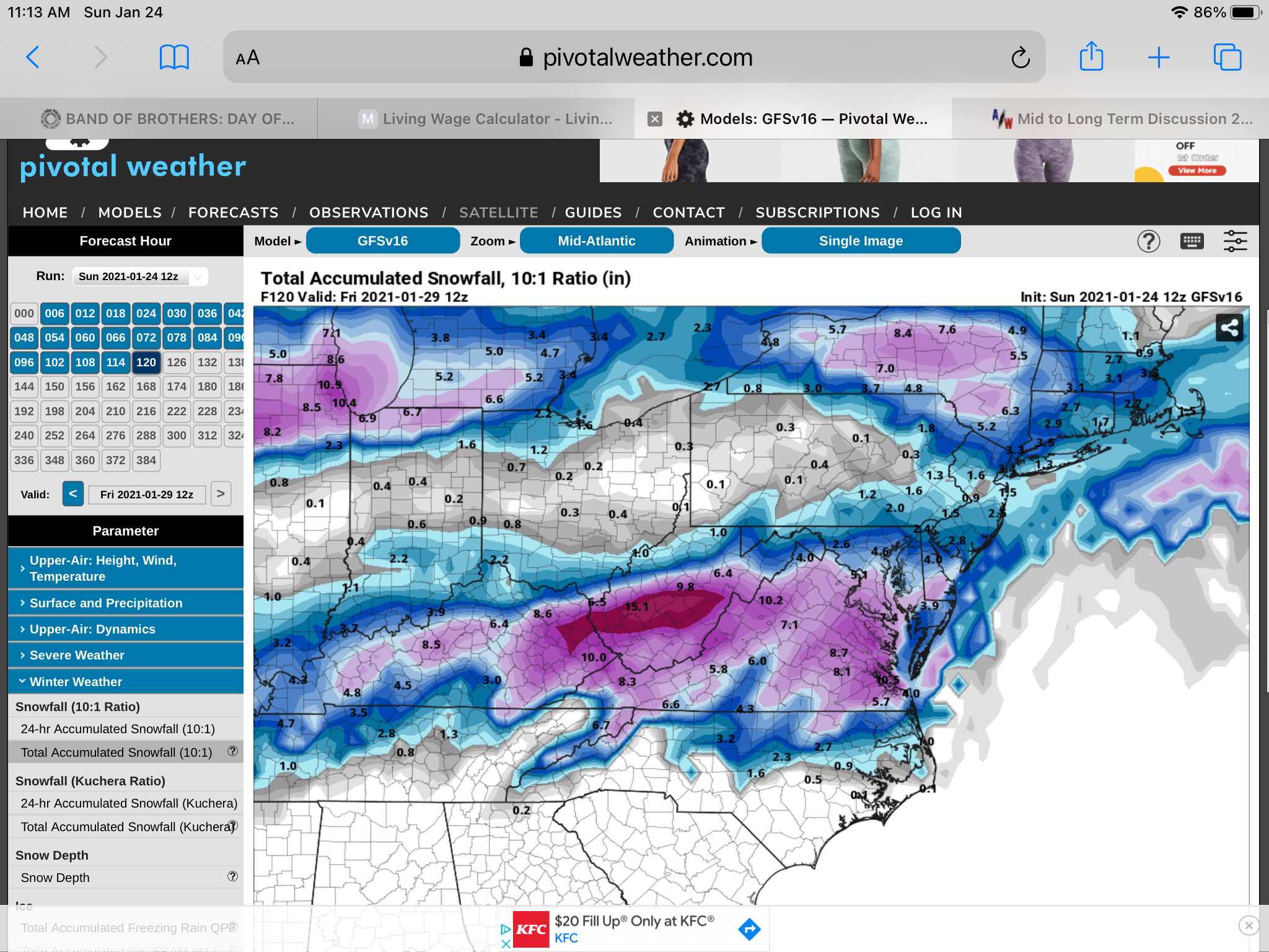
UK brings the snow way into NC

-
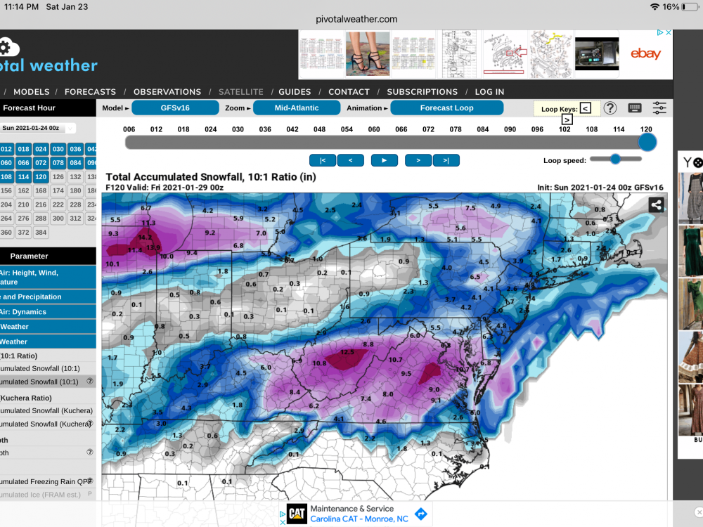
If I’m i’m looking at this correctly. Gfs v16 , and CMC all brought the snow line down into NC. Gfs stayed about the same? Are you guys seeing same thing?
-
1 minute ago, magpiemaniac said:
With every run, this doesn't seem to be NC’s storm.
Virginia is for
loverslosers.
GFsV16 drags some snow well into NC.
-
1
-
-
2 minutes ago, Ghicks said:
I can prob smell the snow from my house just south of cana Virginia
If I look at the map right this gets y’all in the snow. Not as much but it’s some
-
2 minutes ago, BornAgain13 said:
0z GFS continues to pound southern VA and points north.
Starting to get consistency . You guys get your Tylenol ready for the next 3 days
-
I know most of us are out on the storm next week. Did notice at the end of NAm and Rgem that the HP were stronger . I know that’s way out there but might help if correct those on the edge if correct .
.png.1668d9fd8bcb7864b26c1957f781a8d4.png)

Mid to Long Term Discussion 2021
in Southeastern States
Posted
Heck, I end as snow in Rockingham. I would run naked through the streets for this. I’m not biting though .