MAG5035
-
Posts
6,054 -
Joined
-
Last visited
Content Type
Profiles
Blogs
Forums
American Weather
Media Demo
Store
Gallery
Everything posted by MAG5035
-
I’ve been watching the consistent heavy snows on guidance over here and thinking how you couldn’t get any better of a Sunday Night than getting buried while watching the Steelers drop KC on SNF haha. But I’ll be sweating the game and getting the first 6 inches on the ground I’m sure lol. And on that note, it’s too bad this game wasn’t in Pittsburgh. It would be right in the thick of the storm.
-
NAM really doesn’t differ much from everything else track wise, it might actually be a bit SE of the 18z Euro but there is a big difference thermally aloft. The difference is it seems to want to transport >0ºC 850 and 925mb air much deeper and quicker into PA than the others. NAM might be a bit deeper into PA with it but they all have had this insane 60-80kt+ easterly 850mb jet strafing eastern PA so maybe it thinks that warm layer makes more inroads. Gotta remember we’re in hot take range with the NAM yet but this tremendous easterly jet probably should be kept in mind. I’ll be more interested in the NAM probably say 0z tomorrow. Speakling of the wind, I have seen the likes of the GFS have stupid high surface winds and I do notice the NAM has similar surface winds in eastern PA. I could def see 50-60 mph surface winds along the coast but that type of stuff doesn’t normally translate to the surface all the way to Harrisburg no matter how windy it is at Canderson’s house lol. I don’t really see that as a good thing if it happens either because besides the obvious wind related issues, the due easterly fetch right from the Atlantic would probably modify the surface and boundary layer. Just some things to keep in consideration. Otherwise, the other ops and ensembles have been pretty solid today and the previously mixy GFS has gotten a good bit more blue with the p-types today so far while the Euro has continued to hammer a large portion of C-PA. I’ll be riding with that consensus unless/until something changes. This event likely will eventually have mixing issues in some of the LSV for a time as I think this will take the inside track but probably closer to the coastal plain and if we’re lucky closer to the Delmarva. But this should hit hard on the front end and the NAM’s probably too far out to resolve that well yet.
-
Wasn’t he travelling somewhere?
-
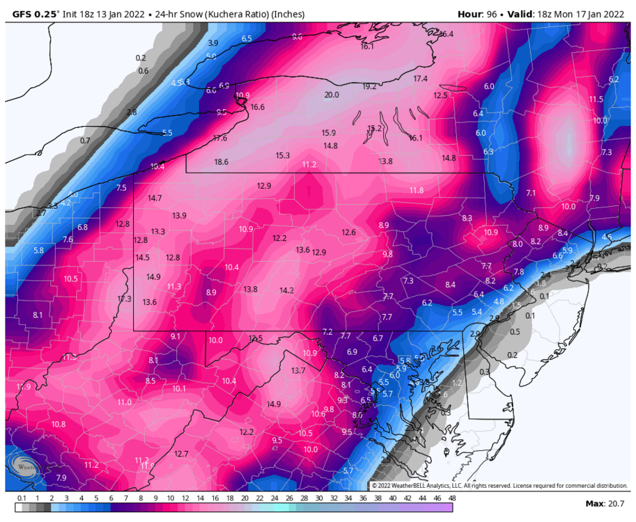
That’s a different interpretation than WeatherBell’s snow map. The GFS on WB has the whole LSV in the 5-7” with no weird reduction like that map. I mean according to that DC is still seeing 6”. If that’s a Kuchera map I wonder if that one (assuming that’s a Pivotal map) calculates it differently. Kuchera is ideal to use in a stable cold snow column. When it’s on the fringes where there could be mixing and/or marginal surface temps (which I’m seeing a good bit of 34ºF in the LSV while still in the main precip) the equation that calculates Kuchera could put out an unrealistically low ratio even if primary p-type is snow. Counter to that, if you have a truly frigid column.. your going to see unrealistically high ratios. At any rate Pivotal and WeatherBell must calculate that differently. Here’s WB, most of the LSV stuff is right up front. I’ll also note that 10:1 in the LSV is pretty similar to this Kuchera.
-
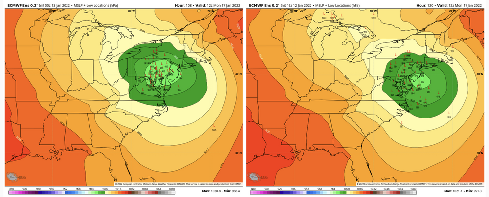
Euro ensemble stuff. Really ramped up accumulation probs in true central and western. Unfortunately also looks like it’s solidified with what the op is trying to sell sending the surface low up into eastern PA. Accum mean: Individual surface low tracks (using 0z vs 12z)

-
Might as well throw in the Canadian ensemble.

-
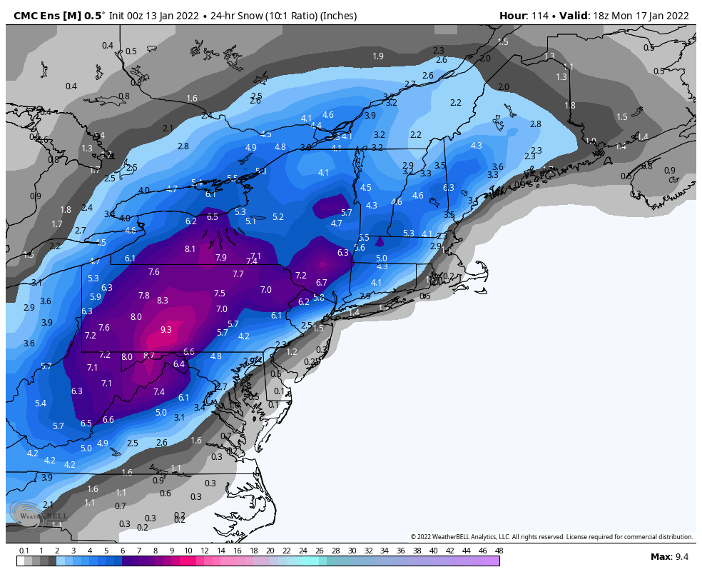
Lol it really is though, the snow mean is down across PA (generally 4-6”) but over a majority of it. I assumed there were several members following the GFS op in punching a lot of mixing into PA but I was definitely wrong in that assumption. I see like one such member, the rest are snow and some don’t really hit PA. Good news I guess is that there isn’t any members that are trying any funny business like making the low more dominant on the other side of the Apps. My educated guess is that the operational models are presenting this system as stacking and occluding as it arrives into the Mid-Atlantic region and giving the models fits in terms of the temp fields aloft and p-type and just evolution in general. For example, I simply don’t see the whole western part of the state sleeting like the Canadian has with the intense precipitation. I would imagine this should be more of a case of how far inside the tracks and how far in the low level warmth punches. And again, this warm punch is brief and happens after the main initial slug of precip. The storm is stacked with the really deep 500mb low moving overhead and should rapidly reestablish a snow friendly column, even with the surface low over PA. The problem is just with the best total QPF residing with the comma head, which would be west of the LSV with an inside surface low track.

-
CTP is likely playing climo likelihood of this ultimately running nearer to the coastline and ensemble support for now, which is a safe bet. It was also mentioned on their AFD of the antecedent cold in front of the system, which will be quite notable. Just realized my grids here have a high of 16 on Saturday, the day before this rolls up. That’s cold. With everything now on board, considering the differences between models.. none of them are really terrible for anyone in this subforum. Even though the GFS/Canadian is trying to Miller B this more than the Euro, it still has robust coastal development well before it gets to our latitude, and it still delivers good up front. But with that setup, you have to wonder with such a strong coastal low about how well those globals are handling P-types at this range. This thing’s progged to be a bomb (low 980s) on the GFS and Euro. Thats nothing to sneeze at. I would think that would quickly overwhelm any surge of warm air in the column from a presumptive remnant OH Valley low and present a snow-mix-snow scenario.
-
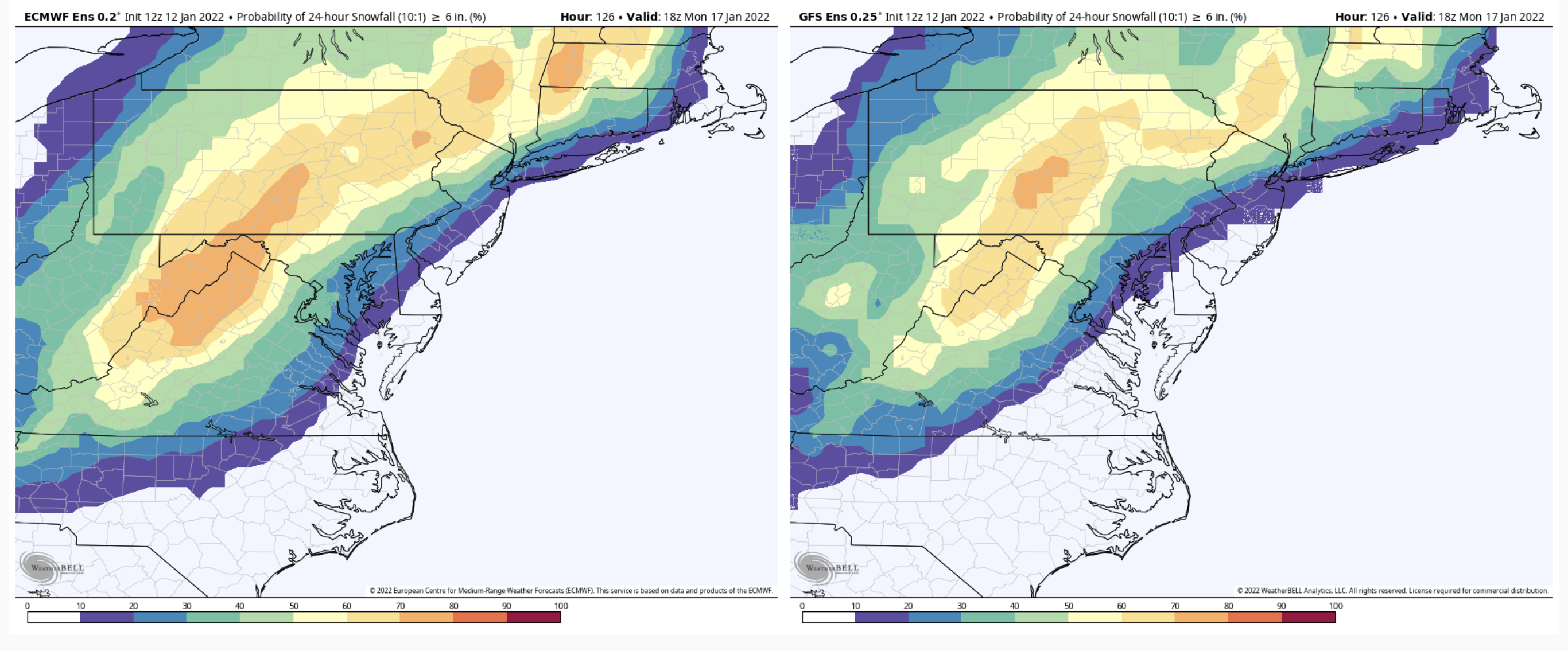
Euro EPS v. GEFS probs. They are really starting to see the storm now. These are 6”+ probs

-
Euro did come inside a bit today vs it’s 0z run, although I think the bigger difference was it was a good bit more expansive on the western side of the snowfall swath. It’s also very sharp with it’s changeover line, mainly snow to light rain and little mixing. Lot’s of time to resolve that track in that situation. I think most of the LSV would still see mostly snow in that scenario, just that it would slot out and since the storm is stacked at the point it’s coming through the Mid Atlantic into SE PA… it won’t be long before the cold air is fully entrained into the system (if it already isn’t). The big thing there is just that the best forcing and deform are further west in PA with the inside track. GFS has had a different evolution, more of a straight Miller B type with surface reflection carrying up into the OH Valley, allowing for more of a mixing mess but still actually looked marginally better today with more frozen as there is strong coastal development. Euro has a bit of a jump to the coast in the Deep South but it looks like more of an A evolution. Truly huge differences between that and the Euro are out in the middle of the country. GFS has over 30” of snow at the confluence of the Mississippi and Ohio Rivers where Euro has essentially 0”.
-
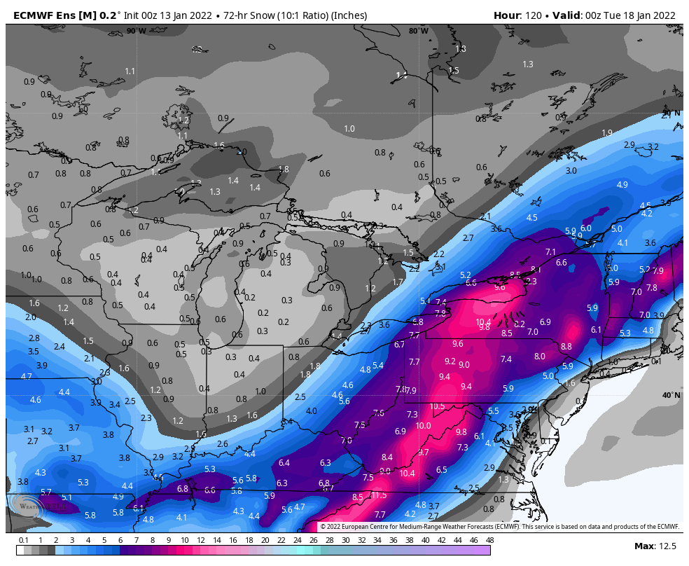
Don’t suppose there will be too many complaints from most in the subforum about the 0z Euro. Swath is a bit west of 12z but still hammers C-PA. 3 and 6 hr QPF at 135hr shows one heck of a deform band sets up right up the Sus Valley thru IPT and into NY. 0z vs 12z
-
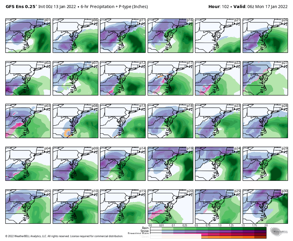
Looks like GFS is still way inside (a tad more than 18z) with mix getting pretty deep into central and the 985 low coming right up the gut of C-PA. Still front end for all and significant central and esp western PA. Guess we’ll see where the rest of the 0z guidance and ensembles set up. Def suspect of that GFS track, I mean it’s possible but certainly not common.
-
I’m not much of an expert of how the computer models work but I do know the individual ensemble members operate on set preconditions/parameters that slightly differ to generate a forecast that accounts for uncertainty, or as NOAA defines it, When considering the Euro control run, the control run of an ensemble is the “best estimate” of the initial state of the atmosphere. I know the meteograms on WeatherBell plot out a GFS control but I’m not sure if that’s factored the same as the Euro EPS. At any rate simply based on the above, given lead time and the amount of moving parts with this…not to mention that the feature that ultimately becomes the system isn’t on shore yet, I’m not surprised there’s a lot of differing solutions within the ensembles. I do think they took a significant step in seeing it vs the operational the last couple runs. Compared to the GEFS, the 12z Euro and EPS seemed more dialed in to each other and the control run looked similar to the swath the op had.
-
I’ll pass on the overall 99-00 Nina analog haha. It was cold but since 1980 it was the 4th least snowy winter at UNV (behind 11/12, 15/16, and 19/20). Unfortunately it has been pretty dry to this point snow wise while looking quite cold overall for the foreseeable future. I was only like 13 at the time but I do remember that winter having blocking but too far east and we missed out on some coastal storms being too far east or offshore. We get this potential storm that should turn that on it’s head. I can kind of see the similarity in the setup between the Jan 2000 surprise and this potential one but as it’s modeled at the moment I think this has a farther west 500mb alignment (western ridge), more amplified, and a much more established system coming across the country. The northern energy for 1/25/00 didn’t phase in until the coastal low was popped off the SC/GA coast. It then had to come right up the coast which was where modeling at the time was extremely late to the game picking up how close to the coast it will run. The lead up to this is different, having a pretty significant wave coming up across the country (that part has been consistently modeled the last several days). The big thing with the last pretty much model cycle or so has been the energy dropping in/behind this wave and allowing it to amplify and come up the coast. I think this has the potential to be a much more widespread storm then that one was.
-
Okay, I’m interested now. Is this going to be another case of the GFS picking this back up first in the mid-range like the Jan 3rd event? There’s a lot of moving parts to this, but we’re going to have the amplified pattern we need to pop one of these big time events. Using Euro here (and Madden voice if you wish), Parent shortwave(s) of this potential system arrive on the west coast (main one Washington and another higher up in BC by about H48, appearing to phase in to a very potent 500mb shortwave and rounding and dropping straight down toward the Gulf. 57 HR 99 HR So a lot of the early phases of this are already within the short range (certainly in NAM range) as far as getting the parent shortwaves on shore to the point of this dropping down the plains toward the Gulf… and this has been modeled pretty solid getting a decent swath of precip to that point. So you’ll see in Hr 99 I marked a few other things and their eventual directions being modeled between then and the next map (Hr 126). As the parent 500mb shortwave slows and amplifies there’s another shortwave that comes in on the BC coast, while the closed 500 low (PV) over the far north of Canada lurks. Dashed line denotes positively tilted ridge axis. This is where it gets extremely important. These features HAVE to drop down behind and force this thing to round the bend, or else we’re sitting high and dry as this potent feature gets forced east and out under us. Today, the likes of the GFS and Euro are doing the former, so we’ll see if that trend continues. There’s big time potential on the table if it does. HR 126
-
It’s got Bliizzak’s on for the winter so we can face off on a long snow covered stretch lol. It’s fun to drive, and it does do really well in the snow with the AWD.
-
Yup sure is haha.
-
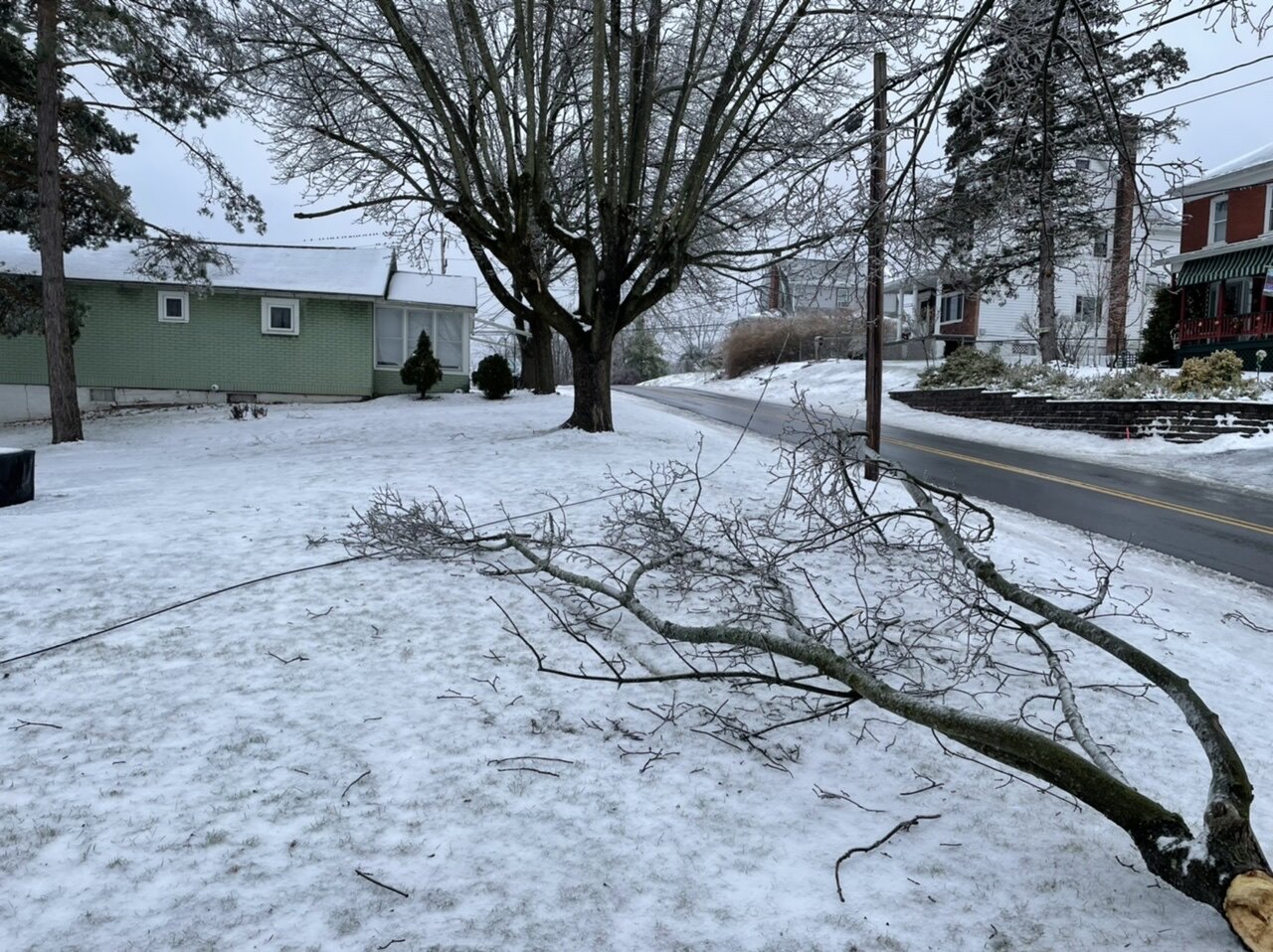
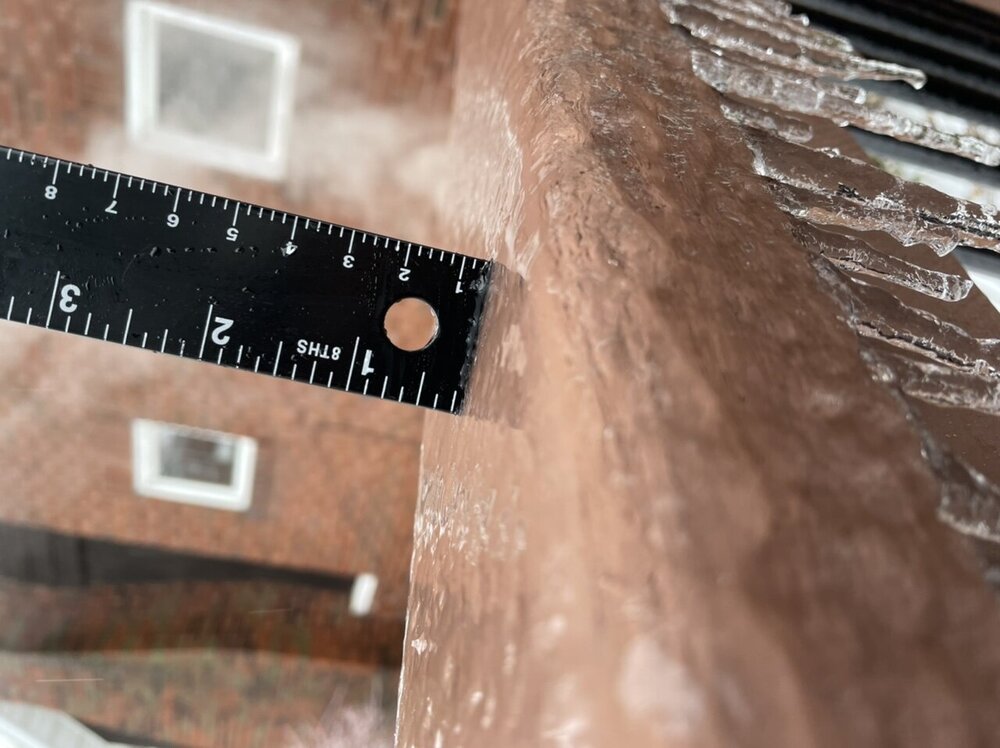
Just got back home, still about 30-31ish. Measured right at 1/4” of ice plus my cable line got taken down (somehow didn’t knock the cable/internet out)

-
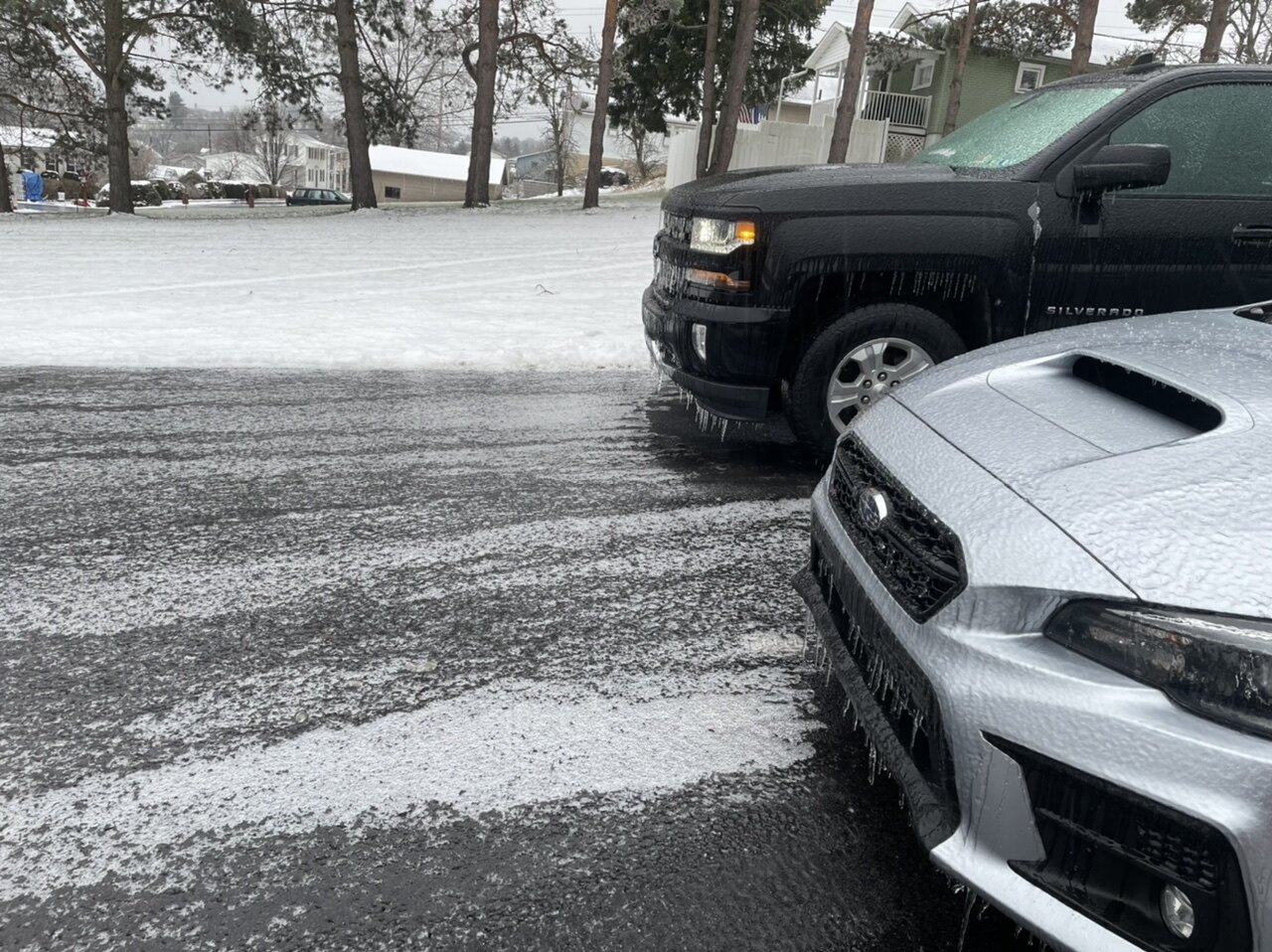
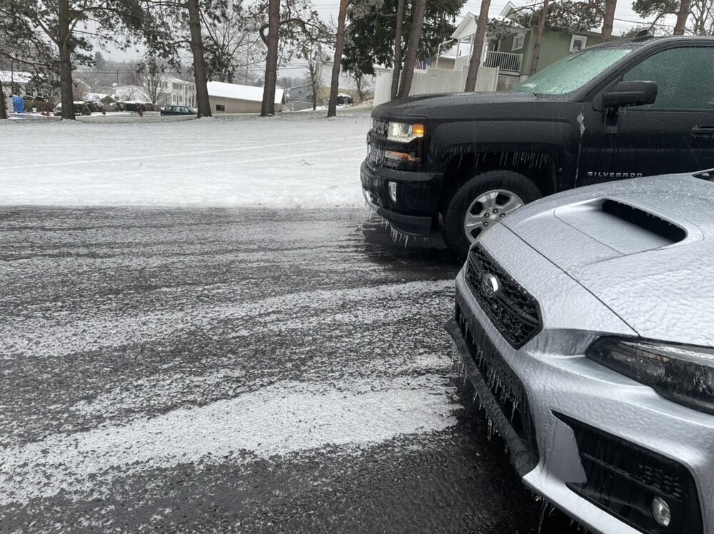
It’s a mess around here this morning as I figured it would be. Still 29-30ish too. Secondary roads look pretty similar to my driveway, state and mains that are treated or were pre salted before are still a slippery slush.
-
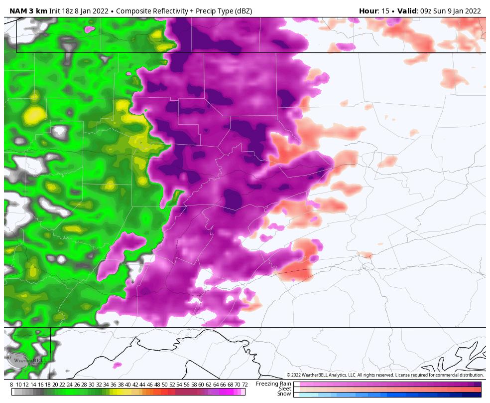
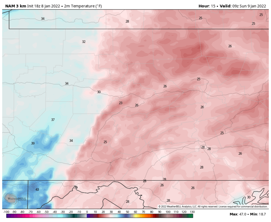
Precip has started. Straight freezing rain, 28ºF
-
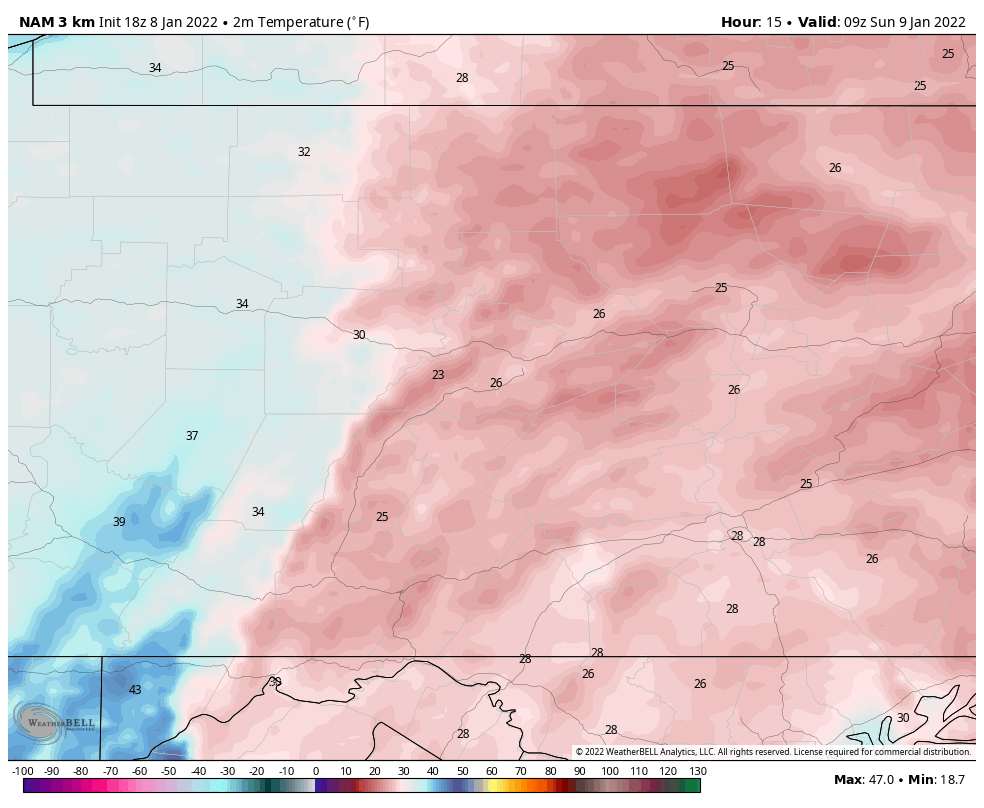
Temps in the low-mid 20s with initial arrival of freezing rain late tonight around here, ugh.

-
This event is also on the Euro control run today in a much more friendly C-PA positioning. Something to see if it sticks when it gets inside D10. Looks like the next event after tomorrow’s icy mess is going to be in the Jan 15-16 timeframe. The overall pattern going forward looks good for the eastern US. I think we’ll eventually be presented with other snow opportunities
-
We haven’t had patterns conducive for them much the past couple winters. Two winters ago we had such a positive NAO/AO all winter that the northern branch track was way too far north for them to track where they need to for our area. Last winter we had NAO blocking galore and got the big hitters but still couldn’t score much of those events in between the December and February storms. The mean trough dumped west of us, resulting in that insane OK/TX cold wave later in February and us being on the front of the trough. And of course, this question offers an opportunity to market the potential for clippers going forward with this pattern haha… because it certainly looks like a clipper pattern to me. Broad ridge in the west and us on the back of the trough (NW flow). It also looks like standard colder phase NINA business with the progressive pattern. Gonna be hard for models to see an individual waves in the fast flow, even in the medium range.. so I wouldn’t be surprised if a lighter event suddenly starts showing up. This pattern is going to have some bigger storm potential but is going to really depend on timing for any phasing of shortwaves.. again standard Nina business. It hasn’t been talked about much on here but we’re running in moderate territory in NINO 3.4 (-1.0ºC), with 3 and 1+2 in high end moderate territory (-1.4ºC and -1.5ºC respectively) this past week, and it has been that way the last several. The latest three month average was -0.8ºC. The Nina is definitely having an influence this winter, so hopefully we can keep the MJO away from 4-6 as much as possible.
-
Agreed, putting the politics/personal opinions aside.. I do read and watch some of his posts on WB and have read his posts in the past when he was still with AccuWx. I kinda think there’s a certain way to “interpret” him if you will, or at least that’s how I approach reading his stuff. He’s very big on analogs and comparing past patterns to a potential upcoming one (often ones that produce a historical past event). And I think the more one realizes that you often can have similar patterns and potential materialize without having it come together for said comparable historical event… the more you can at least kind of see where he’s coming from with any given setup.. He’s also big on sticking to his ideas for as long as possible no matter how sideways the sensible weather pattern gets in comparison. Case in point: this past December. However, I saw a lot of other busted forecasts when it came to this past December and I was wrong in my initial thinking going into the month as well. At any rate, I think that’s a big reason he can come off as sensationalist. That and he has really pushed the 95-96 narrative much more than average this year haha.
-
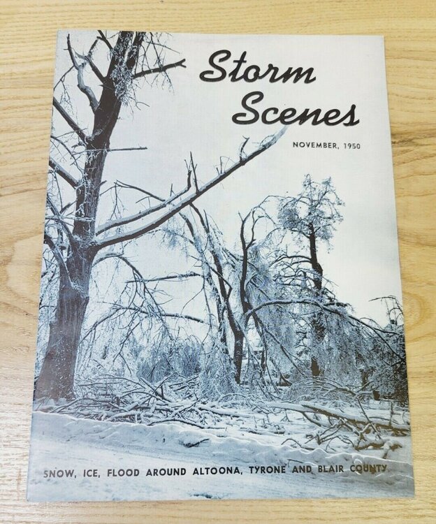
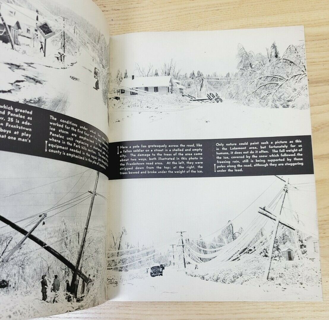
I swear when I was in school I came across something in one of my meteorology textbooks that mentioned KAOO reported more days of ZR on average during a year than any other station in the country. I could never relocate it again, so I can’t really support that claim haha. I do know we see more than enough ice setups in this valley right off the Laurels. I know I’ve mentioned this in the past, but the 1950 Great Appalachian Storm which gave Pittsburgh I believe it’s largest ever snowfall was probably the worst ice storm in the history of this local area and was something of the caliber of that or at least the Paducah ice storm. Was trying to find the article but saw something about it for sale on Amazon. I might have to buy it haha. The pictures just on the preview are insane.