MAG5035
-
Posts
6,078 -
Joined
-
Last visited
Content Type
Profiles
Blogs
Forums
American Weather
Media Demo
Store
Gallery
Everything posted by MAG5035
-
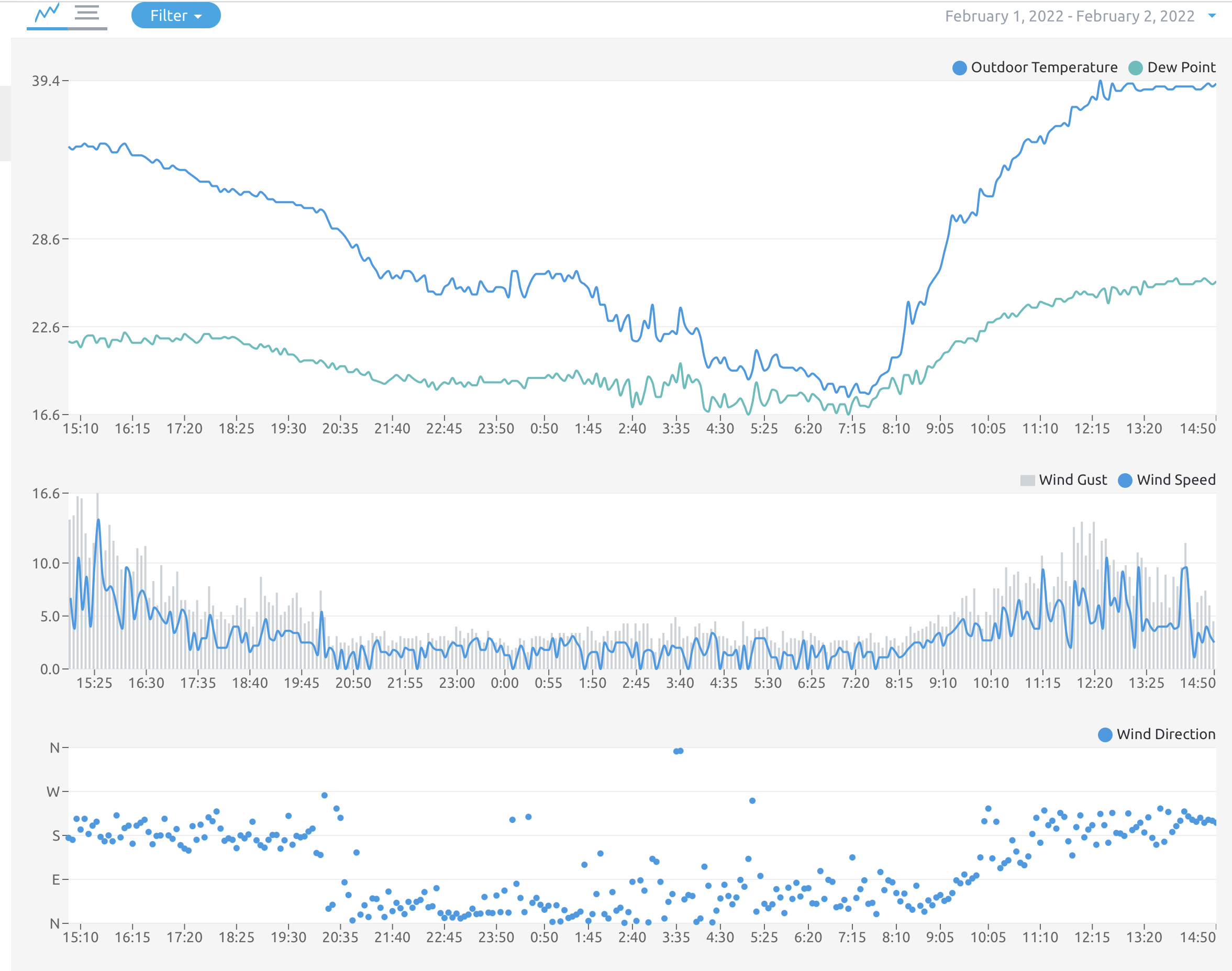
Down to 34ºF, moderate rain. The rainfall portion has definitely exceeded my expectations today around here in terms of totals. Gauge is at 1.42” for the event now.
-
Looking at the Mesowest obs, the 32ºF line is starting to ooze under the I-80 corridor from the north. About an hour or two ago the nearest <32ºF ob I saw from that direction was Coffin Rock haha. The temp here is now near 35ºF and the NNE breeze has ramped up some gusting up to 15mph, so the low level cold air advection is in action. Been watching the HRRR and I think temps could be to a point to start supporting ZR here a couple hours before it’s been advertising it here (by about 10pm or so vs after midnight). Guess we’ll see.
-
Temp has been slowly starting to fall, down to right at 36ºF currently. Since midnight it has only ranged from 34.3 - 37.4ºF today. Winds are light NNE. About the only good thing from this whole mess is I’m finally getting to see how my rain gauge is working. That’s at 0.89” for the event so far.
-
I could certainly at least see a few flood advisories pop up this evening for the smaller tributary and poor drainage type stuff. From what I saw around here before dark there was a pretty good response with run-off and most of the small streams and drainage channels are snow/ice clogged. It’s either doing that or just absorbing into the snowpack.. but definitely not into the frozen ground. Unless there’s any ice jam type issue I think the bigger streams/rivers will be okay, although all those rivers you mention are forecast to get at or near caution stage. Main stem Susquehanna looks to be only a modest rise.
-
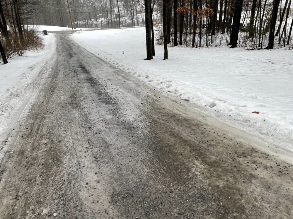
This is pretty much the condition of every non-paved driveway around here today despite mid 30s temps, and we haven’t even got to the actual winter storm part of the system yet haha.
-
That was out of part of CTP’s morning discussion. I agree to a point, you have to be careful with modeled freezing rain as actual observed ice accrual is very sensitive to drop size, rain intensity, surface temps, etc etc. 0.75” of conditional freezing rain QPF on x model doesn’t often translate to 0.75” thick ice on the trees. With all that said, my big thing about this particular event the last couple days is I feel there has been sufficient support to reach 0.25” ice in a good portion of this swath of the CWA mentioned above on that AFD snippet. I honestly expected watches to be issued yesterday on all the counties at least down to I-80 given that support plus this being a multi-faceted potential high impact event between the combo of near warning to warning level ice plus sleet and snow..And they’re still worried about this rain to heavy sleet thing too. As far as surface and road temps, I agree with that in the Sus Valley but most of the interior 2/3rd of the CWA between US 6 and US 22 has a snowpack and frozen ground from the long stretch of cold weather. Some of the secondary roads around here froze up early this morning despite temps above 32 since about mid day yesterday. Plus if sleet does in fact mix in sooner, that’s just going to cool surfaces faster anyways. And further down in the Sus Valley I was surprised first thing this morning that it initially wasn’t included when advisories finally did get issued. I guess I don’t understand why it took so long. A T of ice warrants an advisory, and that has looked likely even in the further reaches of the LSV for awhile. Just my thoughts, I’m not hating on the NWS by any means. Moral of the story is this type of event is very difficult and frustrating to forecast.
-
Haha I normally keep heat around 68ºF or so in the main parts of the house and I can fire up the wood pellet fireplace to warm it up more without bumping up the regular heat.
-
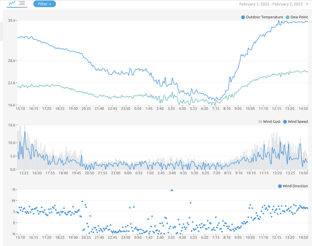
39ºF here this afternoon so far and cloudy with 26ºF dewpoint. Surprisingly it got all the way down into the upper teens this morning (17.5ºF). Not very much snowpack melt, which is currently a 3-6” hard pack in the yard. Since I got this new weather station rolling just after midnight on the 15th of Jan I don’t have full January monthly data but the mean temperature the last 2.5 weeks from then til now is 19.7ºF, and there were a couple 24 hour periods (midnight to midnight) that averaged in the single digits. It’s been pretty cold here lately.
-
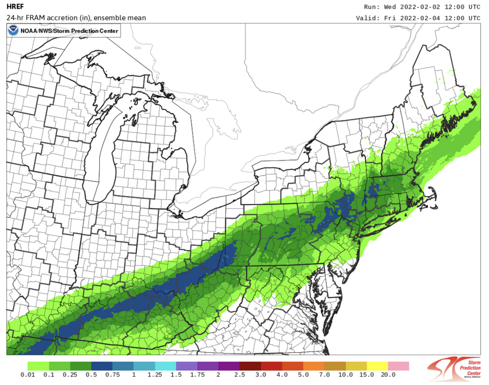
Yea it always is with this type of an event. I kinda disagree with CTP minimizing the ZR threat in favor or a more rain to sleet/snow. I think once that near 1040 high gets positioned just to our north, surface cold is going to try to bleed deeper into central PA before the 925mb-800mb layer cools enough to at least allow for more sleet… which will allow for a longer period of freezing rain. We’re usually lamenting not having a stronger high with these messy systems and we actually have a decent one eventually during this event. We all start this main wave on Thur as rain but I think you guys up there see more frozen (sleet than eventually snow) and a shorter ZR period for a transition, while this area down here could be more 50/50 ZR and sleet turning to T-2” type snow at the end. Then the big thing for the Sus Valley is going to be determining how much ice and sleet can accumulate towards the tail end as the snow threat has been pretty minimal there and the snowier models (GFS and Euro) have really tightened the gradient on the SE side of the swath the last couple runs. Here’s what the 12z HREF had for freezing rain, it’s a model that CTP seems to utilize a good bit in short/near term.. which is another reason I’m kind of surprised the ZR is being downplayed. It has a pretty widespread area of .25-.50” (warning criteria ice) The model only goes out to 48hr and the event isn’t over yet at 12z Friday, so here’s it’s positioning of the p-types at the end of the run.
-
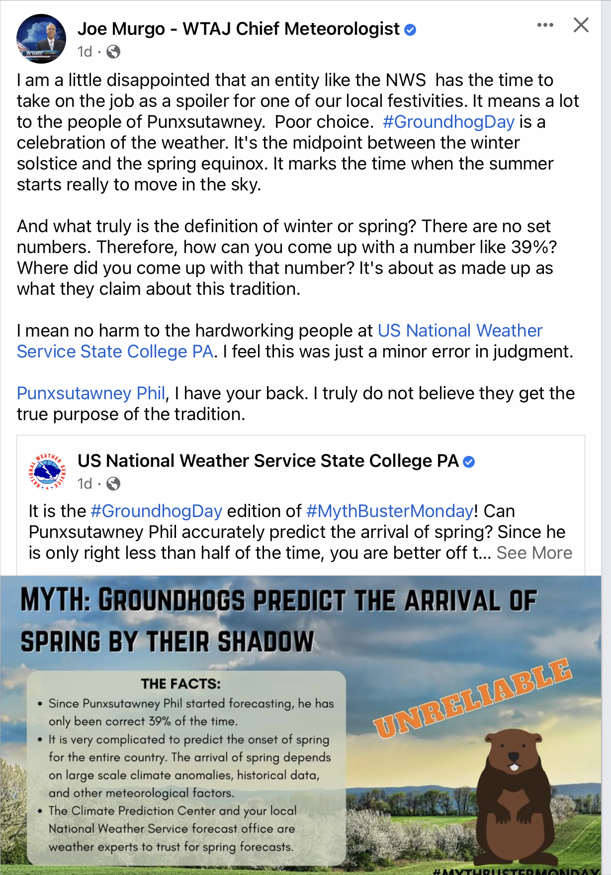
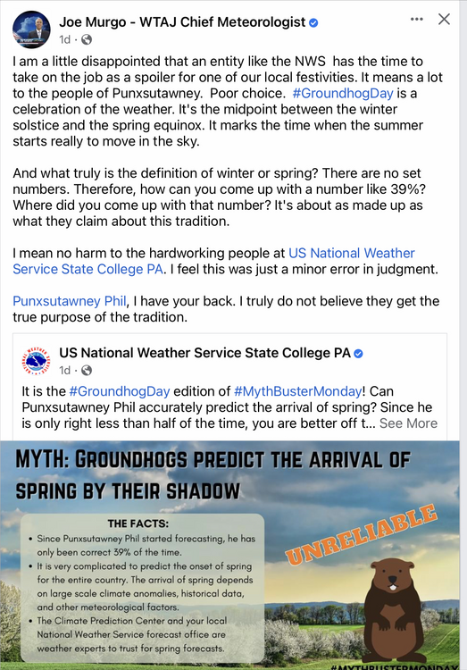
I’ve seen a couple snarky comments on the last couple postings that CTP has put out regarding the upcoming event. A couple comments pertaining to why not put up ice watches, etc etc. I think the CTP criticism that takes the cake that I’ve seen today is our local met going after them about the meaning of Groundhog Day.. @Atomixwxshould get a kick out of that lol. At any rate, CTP has only issued watches in the northern tier counties to this point because that’s likely that only part of the region where warning criteria snow/ice (mainly snow) is a near certainty as it pertains to the whole guidance suite. The rest of the region is a crapshoot at the moment. With the heavy snowfall swath mainly NW, the big issue is how much of every other p-type falls before any potential change to snow NW to SE towards the end. A warmer or colder scenario could both preclude warning criteria icing in the central/upper Sus Valley counties. They also still have time to observe a couple more runs of models as this primary wave of this two pronged system is slated for Thursday. I expect watches to be expanded some overnight as things are starting to zero a little bit on an icing swath that has a good chance of meeting criteria. These type of p-type issues are going to be best resolved with short/near term high res guidance that is just starting to get all the way in range of this. The other thing to consider is the longevity of the primary wave. The 0z 12k NAM for example does get a changover to snow all the way into the Sus Valley but runs out of precip, while the 3k NAM which only goes out to 60 looked like it had a longer lasting event. Just a lot of variables to this. We go through these wave or waves running a pressing frontal boundary type events at least once a winter. They always suck trying to nail them down. I’d almost rather watch another blizzard go up I-95…. Almost.
-
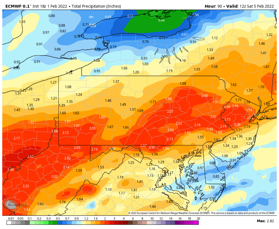
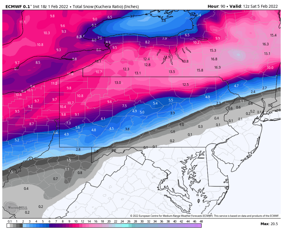
Hmm I’m not sure, the WeatherBell total QPF maps also had the 2.12”. Something’s lumped together probably. Some of that 1.11” heavy freezing rain is likely part of the the 1.23” of plain rain. Adding the 1.23 of plain rain and 0.63” ice is 1.86” and adding approx 3” of snow which was about 10:1 even on Kuchera comes out near that 2.12”. Either way it’s a lot of p-types to sort out of a lot of QPF.
-
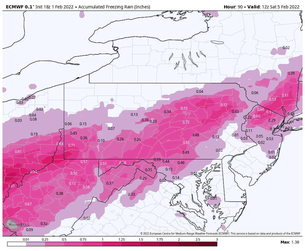
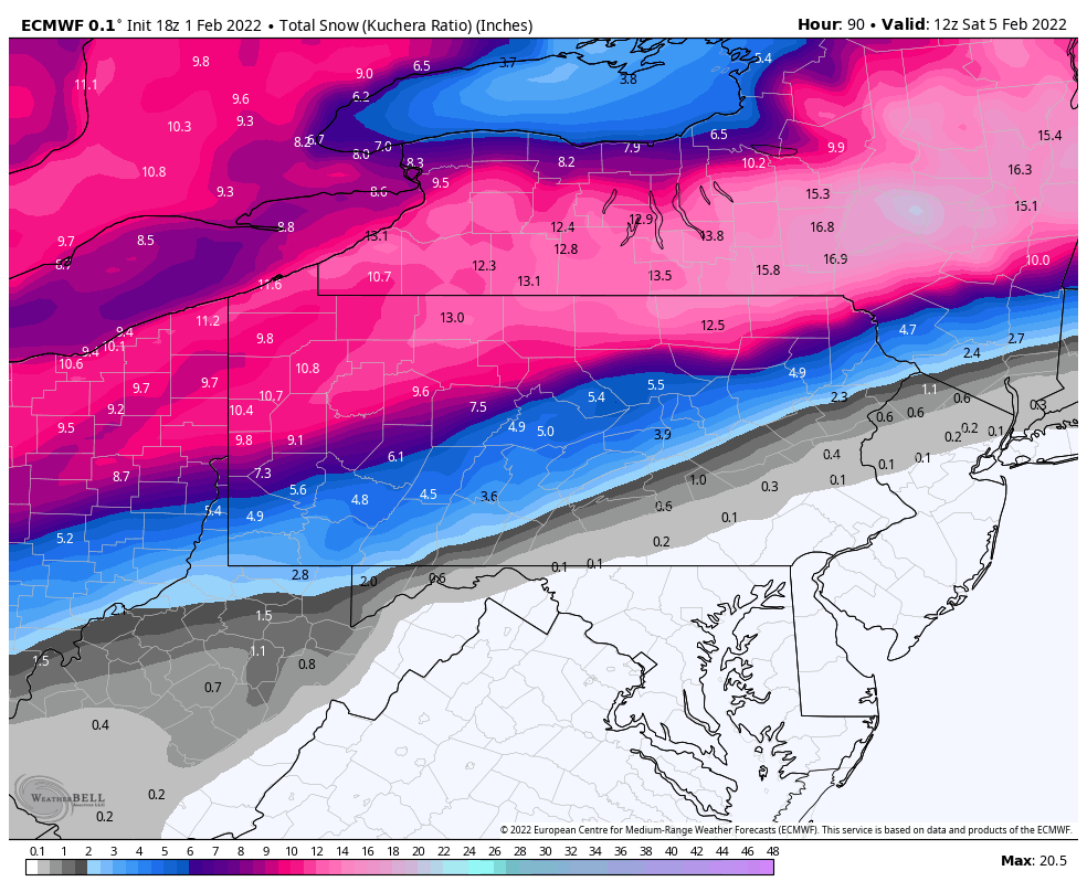
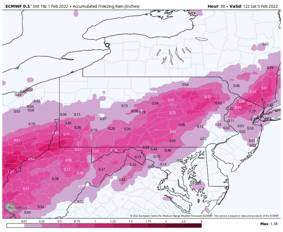
Basic 18z Euro breakdown. It’s about as good if not better in C-PA for snowfall vs the GFS now. Good part of the LSV sees ice. Only bigger difference is in the transition. GFS is a prolific sleet maker while the Euro is more of a ZR to snow transition with much less sleet. Personally I think with this setup there will be a zone of measurable sleet somewhere but that may come at the expense of snow…especially in the central counties where both models do manage advisory snow at the tail end. Euro vs GFS sleet: Euro total QPF: Euro total Freezing rain accum Euro total snowfall:
-
I want to see the map with all the start times for all the different p-type transitions.
-
Here’s the morning take from CTP. Haven’t seen any real breakthroughs with overnight or 6z guidance. Still in the same camps with the GFS op most generous with frozen. Euro/Euro EPS/Canadian seem fairly close having the snow swath further northwest. GEFS sort of in the middle (6z did step back some snow means in the central vs 0z) but still showing a more robust transition. They all show transition for most/all with varying amounts of ice/wintry mix. I still tend to think the GFS has the right idea progressing the front and cold air, which the Euro had that idea a couple days ago. That may not ultimately be enough to get good snows into the Central/Sus Valley, but it would ramp up the mix/icing potential. GFS and also the NAM (which doesn’t cover the whole event yet) have pretty mean looking swaths of sleet accumulations while the Euro has very thin sleet zone but a good bit of freezing rain. Tons of stuff to consider here in addition to where these swaths might end up. Also to keep an eye on, short range stuff like the NAM are starting to pick up on ZR to kick the event off Wed night in central/eastern PA. Given how cold it has been, I’d bet on that scenario especially in areas with snowpack. Some spots could actually have a ZR/Rain/more ZR/mix/snow type of itinerary with this event.
-
Definitely variable temps this morning around here. KAOO at 16ºF but most obs in and around town are in the single digits and it’s 7.5ºF here currently
-
Yea this event looks like a pretty big mess incoming. We will warm up especially Wed/Thur ahead and during the first portion of this system. Def not going to be a tremendous warm-up but some of the southern tier probably gets to 50 or so at some point (sufficient to get the AC fired up down there lol). Big thing I’ve noticed is despite the modeling differing and switching around with how it presses mixed and snowfall into the state, they’ve been building/pushing a stronger high more directly to our north. Initially it looked like the main body of high pressure was going to send the cold southward into the central US and not immediately push east as much. But now we have pretty much everything building 1040+ mb high pressure eastward just above Lake Huron roughly centered in the Ontario/Quebec border region. There’s way too much cold available in this pattern with a stronger high positioned like that, so I’m not buying an all rain event from this, or thunderstorms or whatever. There’s also no low that really cuts west of us on models/ensembles now, so this has tended a bit more progressive. The big question I’m considering right now isn’t whether this cold presses and changes things over to a mix for at least a good portion of folks in here. It’s if we can get the depth of cold necessary in time to turn to any accumulating snow of substance. I do think any really significant snow chances generally favor NW and maybe some of NC PA at the moment, but I also think everyone sees some amount of ice/sleet as well.. potentially significant amounts for some. The setup screams favorability for a long swath of significant ice/sleet along the frontal boundary.
-
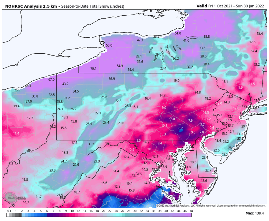
I’m just shy of 20” so far this winter here, which is fine and I’m glad that I’ve been able to hang onto a pack for a few weeks. But that’s also just shy of 50% of what I expect for an average season here so there’s some work to be done. On the other hand, it’s also about 3” ahead of the whole 2019-2020 winter at this point. Give me the winter with tracking opportunities. More often than not things normally even out to some degree eventually. I’d rather be nailing down where an event is going within a good overall pattern over tracking down the actual favorable pattern or window of opportunity just to have a chance at snow. Even in good patterns a specific location isn’t going to make out on every event.
-
Here’s the NOHRSC snowfall for the season to date, which comes with a legend and numbers. Pretty sure this is an estimate derived from model analysis/satellite so the individual numbers at stations might not be what’s officially reported. It’s usually in the ballpark though.
-
Final total was 1.4” I measured very early this morning. There was a nice little fluff band around 3-4am that added the extra. Temp is only 16ºF currently with a dewpoint under -6ºF, certainly a sign of an actual arctic airmass in place. Will have to see if I can get my 3rd below zero low this month tonight, the wind might keep that from happening. Well today’s Canadian and especially the Euro perfectly illustrate my point yesterday about not sleeping on that late week storm. Heck the Euro has 6+ of snow in a large portion of PA along with the ice referenced above.
-
Still some light snow blowing around here. I did reach an inch for this event. Temp 17ºF.
-
Finally back into some snow falling, and this snow globe has bigger flakes this time lol. Should have some better luck accumulating if this patchy snow sticks around for a bit. Surfaces like the cars and the deck were frozen back over by dusk and temp is back down to 26.6ºF.
-
Some additional thoughts going forward… I wouldn’t completely sleep on the next bigger weather system slated late next week being just a straight up big warm up and rainmaker… especially in the more interior portions of C-PA but even region-wide too. First feature of note is mid-week a pretty strong low is slated to track well north of the Lakes and tries to drag a frontal boundary which is likely what the main system will run on. Euro seems more concise with one main wave and GFS a bit drawn out with an additional wave running that eventually pulls the cold boundary and turns a lot of C-PA to ice and frozen just prior to fresh arctic air blasting into PA . There’s also a lot of cold and high pressure on the playing field. While main focus in terms of the strongest high presses cold more into the Central/Mountain West US via a western trough that briefly develops in the western US.. there is half decent high pressure present modeled to our north. Given the range, the globals don’t generally see the CAD as well so there’s the possibility of a messy front end of the event. Most of interior C-PA has an established pack too. The low tracks are pretty close too, really. The 18z GFS for instance takes the eventual main surface low thru PA while the 12z Euro was up into the Lower Lakes and then up the St Lawrence. Timing and progression are going to be important…wouldn’t take too much in what has been a progressive winter for this to be more progressive and suddenly have us more on the better side of the low. The GEFS currently presents a plethora of p-types (at various timing differences) across all of PA. So I’ll be keeping an eye on that since this is still in the 5-7 day range. With all that said, we are going to experience a moderating trend mid week next week (mainly Tues-Thur timeframe). Getting further into February, I really don’t see any reason to not have more chances at snow, even though we may have more changeable weather (ups and downs). We’ll continue to go as the Pac goes as the NAO/AO has generally been positive and continues to stay that way.The AO does dip negative for a time later next week, but generally speaking we don’t have an established blocking pattern in that realm. The big keys are the continued -WPO and neutral to negative EPO maintaining that Pac ridge and continuing to provide a cold source region that will continue to push cold air into the CONUS. I was watching the PNA as it is going to go negative some next week, which is why we moderate as ridging builds in the East. This is gonna be nowhere near the magnitude of the -PNA in December and it is forecast to quickly go back into positive territory some. The other thing I’m watching is the MJO. It is currently in the null phase (circle of death, etc).. basically right now it’s in a position where it’s not exerting a significant influence into the Mid-Latitudes. Which is fine.. the ECMWF pretty much keeps it there indefinitely. The JMA and NCEP stuff eventually get it into phase 3 (still a cold phase) and the NCEP spaghetti plot does show some potential of this to perhaps eventually run into 4 and so forth. With the other regular teleconnections staying pretty serviceable for now (esp on the Pac side) the only thing I really worry about is a new stronger MJO pulse running the 4-5-6 gauntlet… especially in a full blown mature Nina. Something like that would obviously likely ensure our overall chances of winter weather are much lower during such a period. Fortunately, A. That’s not really showing currently, just a concern of mine and B. Even if this were to start showing say within the next 6-10 days it would be probably be after mid Feb before we saw any sensible pattern changes. So going forward, yea we’re not going to win all the storms and probably warm up here and there.. but there remains plenty of cold in the pattern and plenty of chances down the road at least the next couple weeks, IMO.
-
There were a couple scattershot runs in the 8-10 day range that got us maybe, otherwise this thing was a non-event even in most of New England until inside D5 when it finally started phasing into a bigger storm on all guidance. Then once it was seen consistently everything with the coastal was mostly 95 corridor east. As I mentioned multiple times the last few days this northern branch system and frontal wave pressing to phase in was the key to us seeing at least widespread snowfall… which we do have but just not the rates. We rarely do well when the coastal doesn’t start organizing in earnest til it’s off the NC/SC coast (well off it in this case). This needed to start happening in the SE US/Gulf region.
-
Well I’d call it a snow globe out there since late this morning but I’d probably end up returning the snow globe for one that has bigger flakes in it. It’s been mostly a steady light pixie dust with temps steady around 28ºF. With the fine snow and light rates, the little bit of solar insulation there was has been enough to keep accums off of every non-snow surface except the glass table on my deck and my snowboard… which both somehow have about a half inch of new snow. At least it’s accumulating where it counts (on the snowpack) haha.
-
That 0z Euro run that just dropped has to be one of the most insane runs the southern New England folks have ever seen. The low passes just a hair outside the benchmark and tucks right into the Gulf of Maine. And I’m sitting here just hoping tomorrow I get 1/42nd of what Boston has on that Kuchera map lol.