MAG5035
-
Posts
6,054 -
Joined
-
Last visited
Content Type
Profiles
Blogs
Forums
American Weather
Media Demo
Store
Gallery
Everything posted by MAG5035
-
Central PA Winter 2022/2023
MAG5035 replied to Blizzard of 93's topic in Upstate New York/Pennsylvania
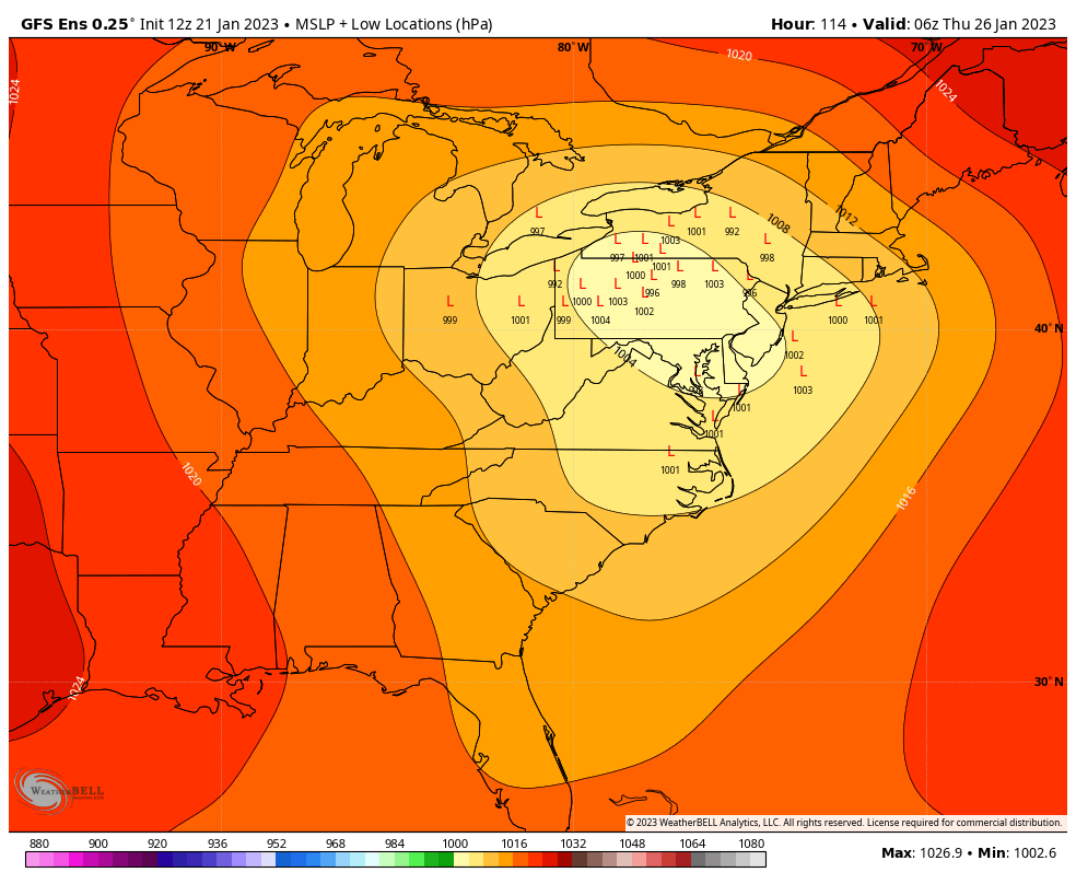
I have mostly been liking what I’ve seen from guidance in terms of trending towards a stronger Canadian high that is in a decent position and doesn’t necessarily retreat rapidly either. Looking at 12z suite GFS had a stronger high than the Euro (1035ish vs 1030ish). Comparing ensemble means GEFS and EPS have similar strength to the high (1030ish) with the GEFS mean suggesting a somewhat better positioned high. The Canadian suite is interesting, the op manages to be the furthest west solution while the ensemble mean is in line with the others and is most suggestive of transferring a low to the Delmarva coast. The Euro ensemble has some clustering as well. Obviously, if this managed to secondary that far down the coast.. that would fare well for extending frozen/mixed precip in C-PA. Even without much transfer to the coast, I feel there should be enough of a wedge in place initially to see measurable snow (at least 1”+) in all of the LSV. Globals don’t always see CAD the best, especially more at range. So it will be interesting to see how the short range high res models handle things when we get to that point. Right now, the ensemble blends seem pretty good in terms of mean placement of the major features. We still have some time for getting details sorted out. GEFS: EPS v Canadian ensemble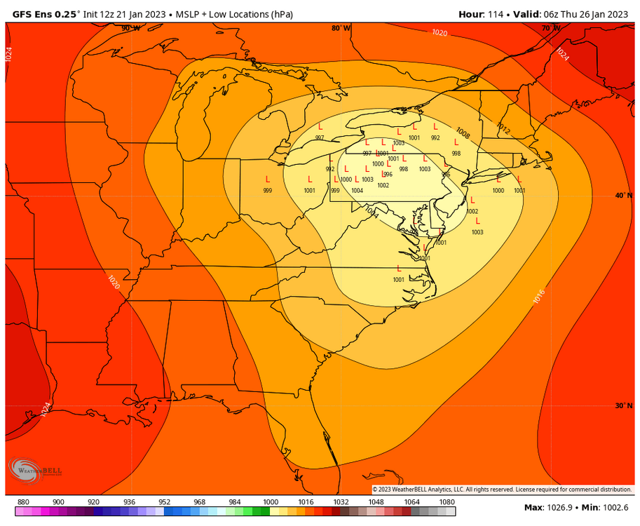
-
Central PA Winter 2022/2023
MAG5035 replied to Blizzard of 93's topic in Upstate New York/Pennsylvania
Yea it’s a similar type setup but I don’t know how the direct comparison is going to end up panning out. It will almost certainly be a warmer version of that type of gradient pattern, at least with the next couple events upcoming the next 5-7 days. The Feb ‘94 gradient pattern was preceded by a really snowy and frigid January. Yesterday and the current date in 1994 had all-time record cold and lows from -10 to -25ºF over most of the commonwealth. Probably a bit understated to say that we don’t quite have that kind of airmass coming into this stormy period. We still don’t have much anomalous Canadian cold yet through these next couple events. Getting some high pressure set up prior to the Wednesday event should at least help get the O-fer the winter crowd in here their first measurable snow if not first 1”+ event. Basically the possible difference I’m trying to lay out here (at least to start) is that gradient pattern was attacking much colder available air and an established snowpack. The current upcoming pattern is going to have to establish pack in the upper Ohio Valley, lower lakes, and our region where there is currently zero snow. So while I see the next two events getting a lot of that done, some portion of our southern tier is probably going to be part of the gradient zone between snow/mix and predominantly rain vs Feb 94’s which delivered a bunch of ice/sleet events well down into the Mid-Atl region (DC/northern VA/etc) with a much colder available airmass. Models actually establish some anomalous Canadian cold toward the week 2 timeframe with some SE ridging eventually trying to persist but with better cold available trying to press from Canada. So that week 2 timeframe could end up more favorable overall for the LSV and probably northern Mid-Atlantic for frozen events if we keep an active pattern. -
Central PA Winter 2022/2023
MAG5035 replied to Blizzard of 93's topic in Upstate New York/Pennsylvania
You got the WS-5000 station right? -
Central PA Winter 2022/2023
MAG5035 replied to Blizzard of 93's topic in Upstate New York/Pennsylvania
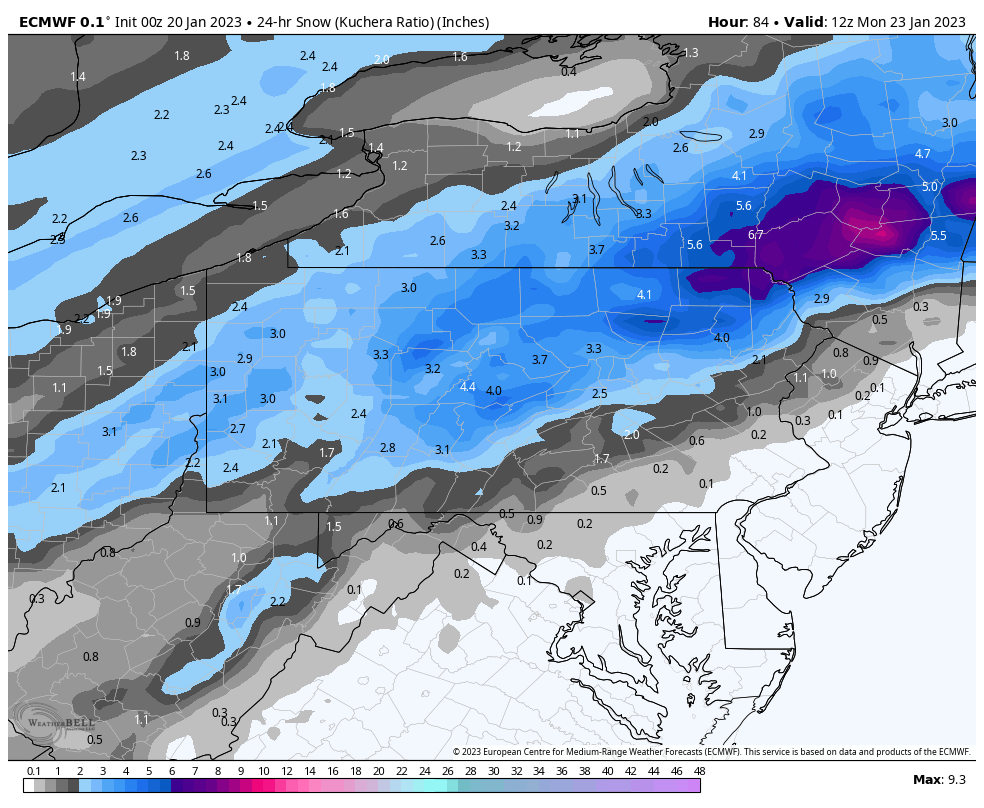
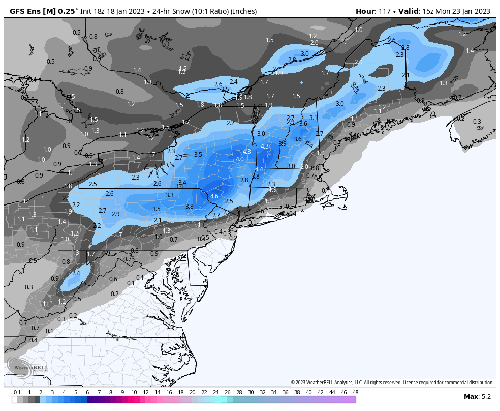
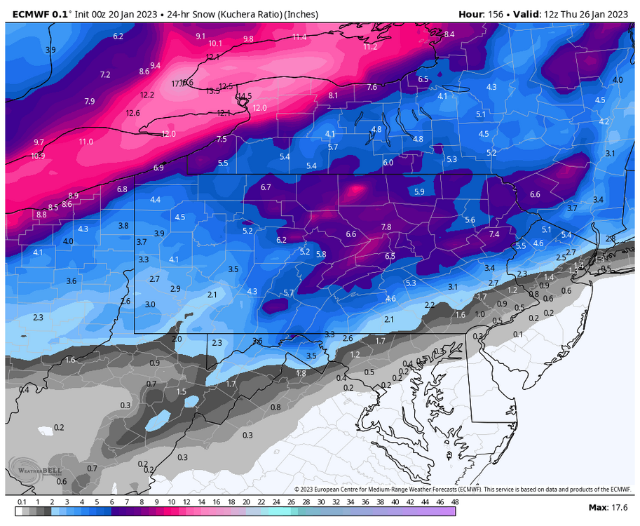
Still no 0z GFS tonight, they can keep it unplugged lol. Here’s 0z Euro for the Sunday storm And for Wednesday’s storm: Euro achieved this with the 2nd storm despite taking a straight up primary up the Ohio Valley to Erie with little secondary development. Progged an okay high to the north allowing for a pretty big thump up front. Using Kuchera here, the 10:1 actually had higher amounts on the fringes of the accumulation swath.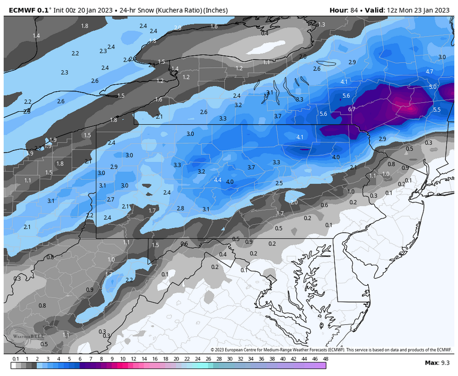
-
Central PA Winter 2022/2023
MAG5035 replied to Blizzard of 93's topic in Upstate New York/Pennsylvania
Not sure why my WB hasn’t loaded any of the 0z GFS in yet but in the meantime.. here’s the early prediction sure to go wrong just issued from CTP.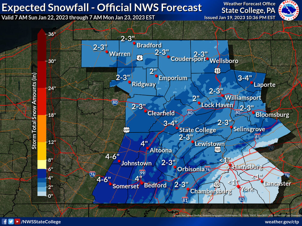
-
Central PA Winter 2022/2023
MAG5035 replied to Blizzard of 93's topic in Upstate New York/Pennsylvania
It wouldn’t have my vote lol -
Central PA Winter 2022/2023
MAG5035 replied to Blizzard of 93's topic in Upstate New York/Pennsylvania
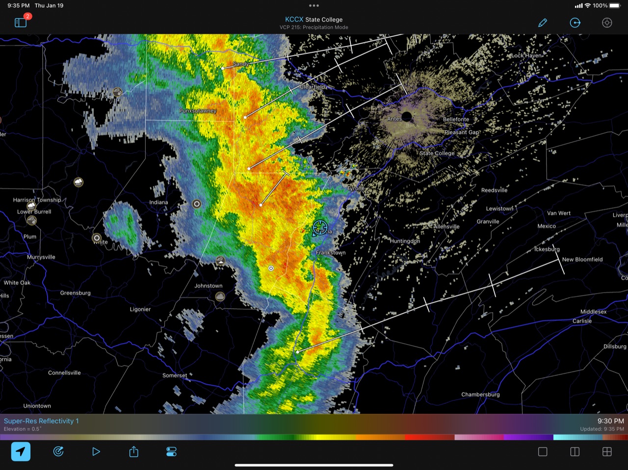
Getting multiple strikes of lightning/thunder.
-
Central PA Winter 2022/2023
MAG5035 replied to Blizzard of 93's topic in Upstate New York/Pennsylvania
Cold front’s on the doorstep. Looked like there were several mPing reports of small hail toward the Pittsburgh area and western PA with it so we’ll see if I can get in on any of that. Hey it’s frozen.. a T is a T lol. -
Central PA Winter 2022/2023
MAG5035 replied to Blizzard of 93's topic in Upstate New York/Pennsylvania
Indeed, the classic benchmark for C-PA snowstorms is the ridge axis thru Boise, ID, which this doesn’t have. Although the Sunday system doesn’t either, I think the shortwave that dives into the SW behind it (which becomes the Wed storm) acts to eject that out instead of amplify.. which could explain the trend for Sunday to be a bit of a weaker system and one that gets to the coast easier. Even if Wed does cut, I think there will be a somewhat better antecedent cold air mass in place for that with enough high to the north to support frozen up front at least. GFS had the weakest high to the north to go with a dominant primary and thus had the least frozen/mix. Whatever secondary coastal low evolves will also dictate how long that can hold. Even the big Euro run yesterday featured a primary to a coastal secondary with this, the transfer just happened much faster and today’s run has a stronger primary that’s overall a bit further west today.
-
Central PA Winter 2022/2023
MAG5035 replied to Blizzard of 93's topic in Upstate New York/Pennsylvania
0.89” of rainfall today, temp still 38ºF. Looks like most precip is done here until possibly fropa later this eve. Maybe can manage to score whatever upslope/LES that manages to blow off the Laurels tomorrow to go with the wind advisory. -
Central PA Winter 2022/2023
MAG5035 replied to Blizzard of 93's topic in Upstate New York/Pennsylvania
GFS takes a primary along to the Lakes with the coastal for the Wednesday event as well. True central goes from ice to snow at the end but obviously not ideal. Canadian has front end snow that goes to mix/rain in the LSV as the coastal low goes by for Sunday event (not to the Wednesday one yet) -
Central PA Winter 2022/2023
MAG5035 replied to Blizzard of 93's topic in Upstate New York/Pennsylvania
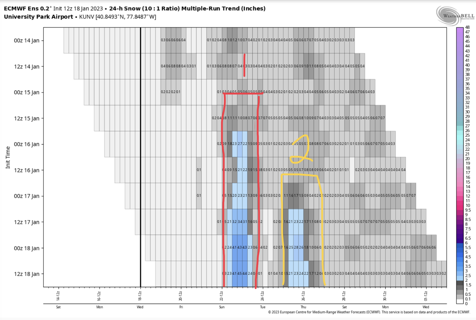
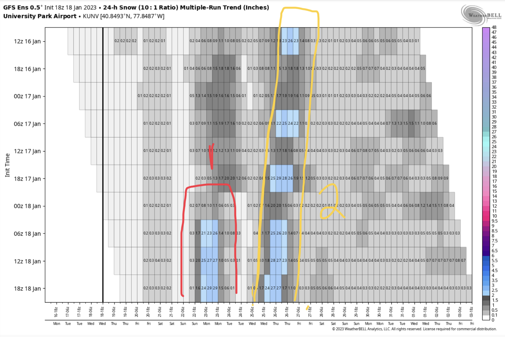
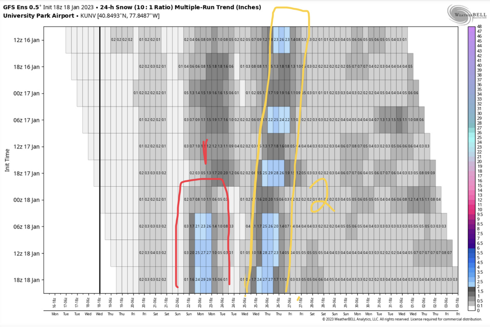
Yea the most consistent actually. Weatherbell has newer tools in its meteograms section to see trends. Here’s Euro EPS v GEFS, I’m using UNV this time. EURO EPS GEFS The initialization timescale is a bit different between the two since the GEFS includes 18 and 6z runs and the Euro EPS only uses 0 and 12z, but you can see the Euro EPS started dialing this Sunday event in with the 0z run on the 16th, while the GEFS finally started seeing it better this morning at 6z, though you can see it has seen the event to a degree. . Conversely, the GEFS started seeing the potential 2nd event before the Euro EPS. These products are available for the op models too. And of course the GFS op’s first run that had measurable snowfall with the Sunday event at UNV was the 12z run today.
-
Central PA Winter 2022/2023
MAG5035 replied to Blizzard of 93's topic in Upstate New York/Pennsylvania
Here’s a look under the hood of the ensemble guidance at a location. Using MDT here. 18z GEFS 18z Euro: This really brings out the difference that remains in the ensemble camps in an area (LSV) that figures to be the biggest tossup trying to establish where the R/S line might setup and if most LSV sees mainly rain, mainly snow delivering sig accums or something in between. Recall the favorable low clustering the GEFS has. Despite that, GEFS presents 11/30 measurable with only 2 of those big hits with the other 9 minor measurable. Euro EPS has way more supportive (reflecting a colder column overall) with 50/51 (plus the control) showing measurable with almost half of those being a moderate snowfall.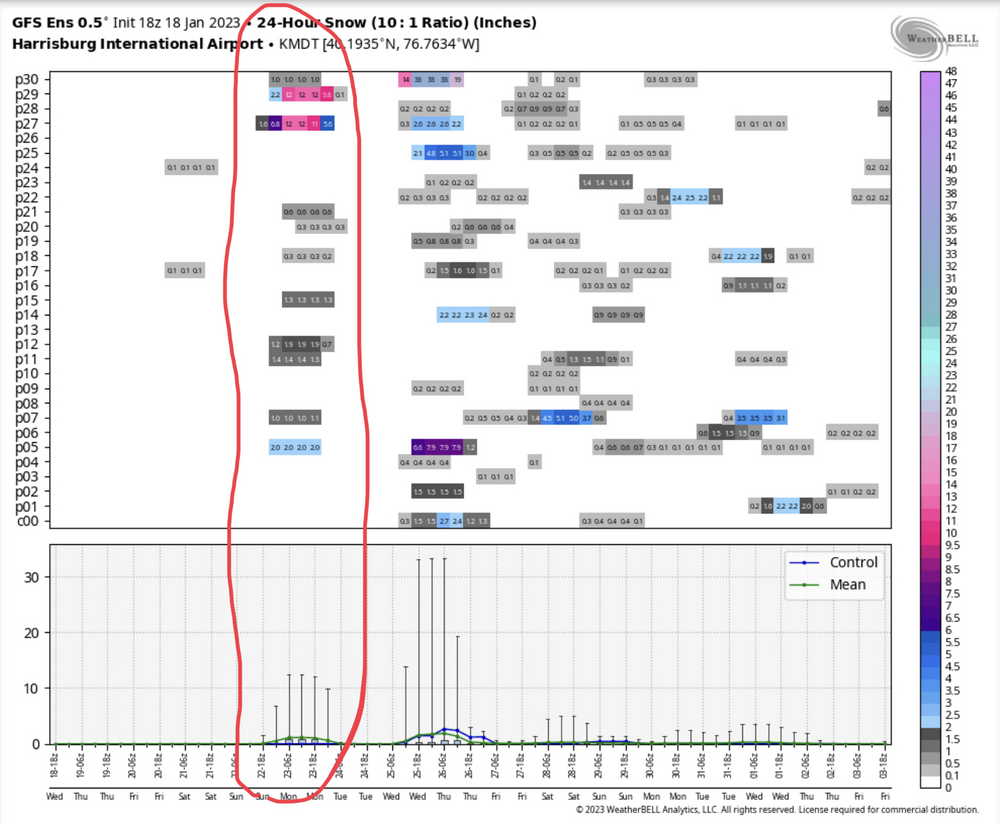
-
Central PA Winter 2022/2023
MAG5035 replied to Blizzard of 93's topic in Upstate New York/Pennsylvania
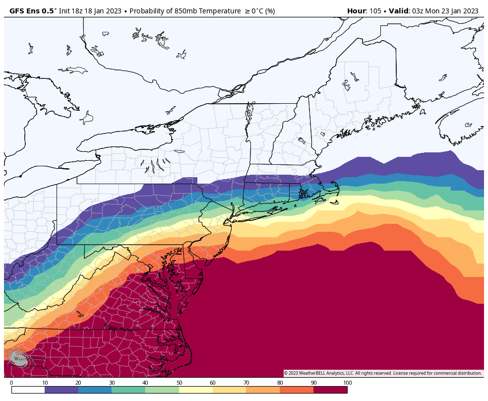
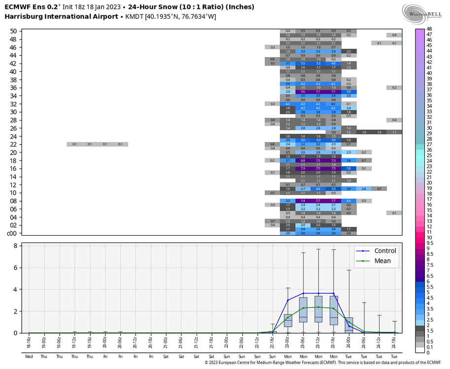
The GEFS is still somewhat reflective on what the op was doing thermally despite the good clustering. The result is the snow swath it has focuses more on the northern half of PA. Probability of 850mb temp being above 0 via the individual members: 24 hr snowfall swath (mean): And I’m just doing analysis here, I’m not necessarily favoring one thing over the other right now. I mean gut says a fairly strong low tracking to the Delmarva and up (esp if it gets along the actual coastline instead of just inside) would deliver snow to all of central and at least a good portion to the Sus Valley… but we’re not working with any anomalous cold temps surface or aloft (850s are actually + anomalies). GFS could end up being more correct thermally even though with the low evolution it caved to the rest of guidance that featured a more dominant coastal low. Just putting the options out for consideration.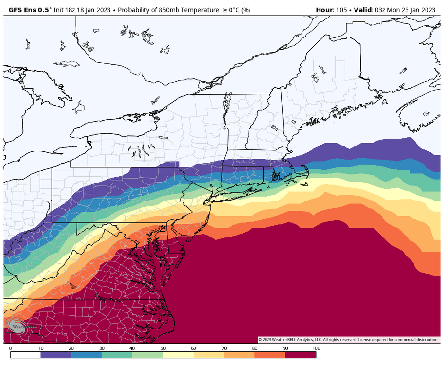

-
Central PA Winter 2022/2023
MAG5035 replied to Blizzard of 93's topic in Upstate New York/Pennsylvania
GFS wasn’t super far off from 12z (it’s 12z run and vs Euro) in terms of its coastal track, which came a little bit further inside at 18z. It still should have hung decent snow on central/western PA on that track. The big difference was thermals. Notably warmer aloft preceding the event than the Euro, which may have to do with it holding more of a surface reflection west of the Apps coming up and pushing just enough of a warm nose into all of southern PA to make it messy and delay a changeover back to snow as the column cools with the deepening coastal low. It is an important thing to consider with this system, as we won’t have much surface high support and will be relying more on where the gradient is and the developing coastal low to eventually start pulling favorable thermals back toward itself as it quickly comes up the coast. These are the details to get sorted out the next couple days but I’m sure it’ll take getting into NAM/HuRRR range to really get some kind of good handle. Big thing for now is at least the GFS continues to develop the decent coastal low getting to the Delmarva region. This had about been the only model that consistently wasn’t doing that (keeping primary west of the Apps to the Lower Lakes) the last few days until today. -
Central PA Winter 2022/2023
MAG5035 replied to Blizzard of 93's topic in Upstate New York/Pennsylvania
Your welcome I edited my post but they had a bigger long term yesterday talking about tomorrows system and the Sunday system and all they did was remove the part about tomorrow system today (now in the short term) and kept the part about Sunday there. I’d expect an update for that section in the next couple hours, as they usually do in the later afternoon. -
Central PA Winter 2022/2023
MAG5035 replied to Blizzard of 93's topic in Upstate New York/Pennsylvania
If you were reading the long term portion of their discussion, that has yet to be updated this afternoon (still yesterdays disco). Edit: They had a bigger long term yesterday which also included tomorrows system and removed that and kept the portion of the discussion referencing the Sunday system. -
Central PA Winter 2022/2023
MAG5035 replied to Blizzard of 93's topic in Upstate New York/Pennsylvania
Boy this sure escalated quickly today. I had been reluctant to really pull the trigger on Sunday’s event until I saw some kind of clarity between the GFS/GEFS and everything else, especially in this situation where the GFS was simply taking a primary cutter west of the Apps with little or too late secondary development for us ( a viable outcome considering how the season has gone). Definitely significant that it finally came in line for the most part with Euro/Canadian guidance that had predominantly a coastal low. Presuming that holds in ensuing cycles… focus can start on how much of C-PA this may impact with snow. I still see the LSV (esp Adams/York/Lancaster) as fairly vulnerable in this setup. A slightly inside track from VA into the Delmarva/southern Jersey is would likely straddle the R/S line very close or into southern PA (LSV) during at least a portion of the storm. Obviously a bit more progressive/SE would help that particular area. Those details will get sorted out the next couple days. The next one (25th/26th) is definitely one to watch as well, as that will likely take a similar track coming fairly quickly behind Sunday’s system (3-4 days). The gradient might shift a tad south for that system as well. This is a prime opportunity to score once or twice in the next week. There’s likely to be a swath of big snows on the ground for whoever is lucky enough to see it delivered from both systems. -
Central PA Winter 2022/2023
MAG5035 replied to Blizzard of 93's topic in Upstate New York/Pennsylvania
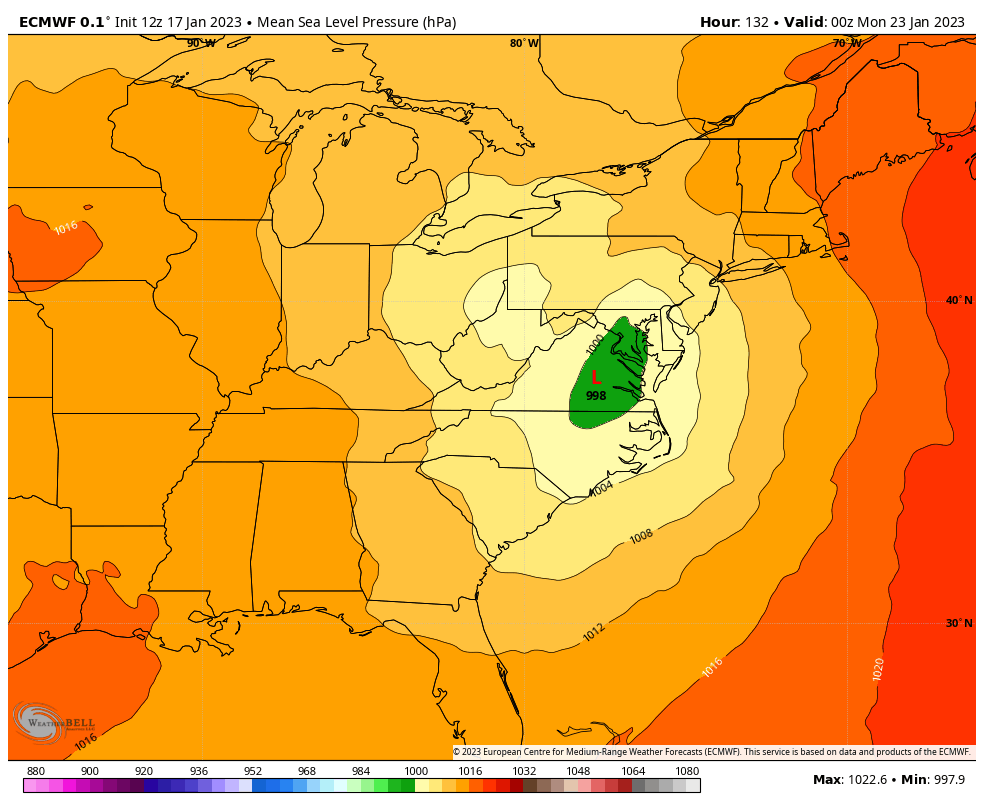
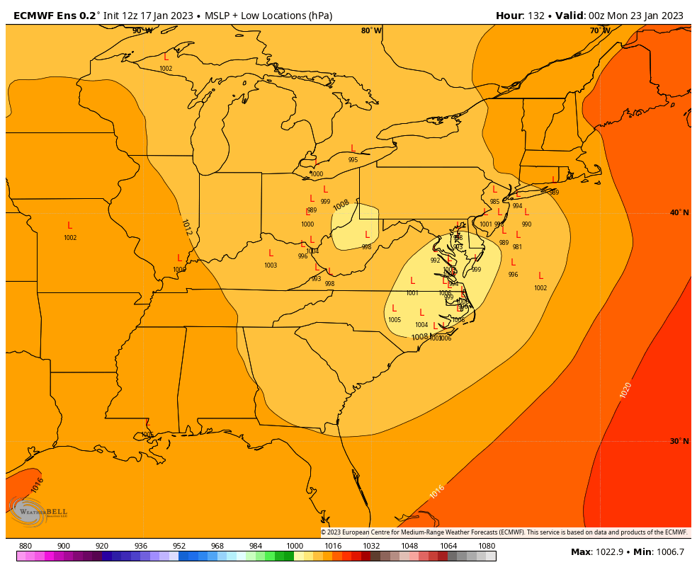
12z Euro track is just a hair too far inside for the LSV for the 23rd storm, putting the rain snow line between Harrisburg and York/Lancaster. The Euro ensemble mean has a much better look for CTP as a whole, clustering the lows more along the coastline… making for less of a C-PA divider in the snow dept. 12z Euro op (132hr) 12z Euro ensemble cluster (132hr)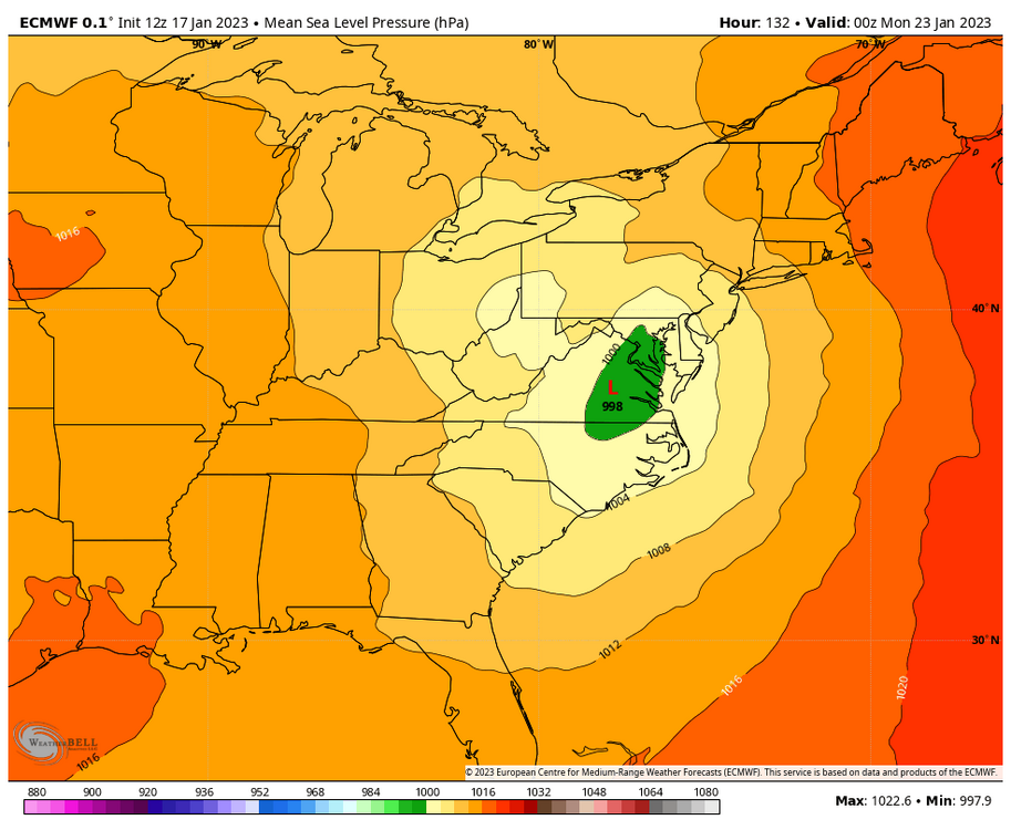

-
Central PA Winter 2022/2023
MAG5035 replied to Blizzard of 93's topic in Upstate New York/Pennsylvania
I do like the overall look of things as we get toward the end of the month into early February. Seeing the cold anomalies in Canada replacing the sea of red positives is a good start even though the press focuses west/central US initially. We did kind of just go through this in December, where we were initially targeting significant cold being here by mid month and we didn’t get it until after mid-month and the really cold stuff waited until 2 days before Christmas. We’re likely looking at the same kind of progression here if it does eventually get cold. I think enough cold will eventually press our way but big question will be if we can knock back the SE ridge enough to finally get on the cold side of the storm track for a change. It doesn’t appear that way for the 19th storm (other than maybe brief interior ice in the beginning) and the next one around the 23rd or so is still debatable, although I continue to think that one has a better chance to at least have some kind of a mixing event up front if it cuts. Overall we’re likely going to have to take a couple more lumps storm-wise the next 7 days or so. Other question is sustainability if we can get the cold period. MJO could be a factor in a bad way if it eventually propagates into the P4-6 realm (talking beyond 15days at this point for this). That was a big reason our Christmas week cold got cut short. Models generally seem to want try to turn it back into the null phase before it goes from phase 3-4 for now but that evolution will need to be monitored. That’s likely to be a player on how mid-late February fares down the road. -
Central PA Winter 2022/2023
MAG5035 replied to Blizzard of 93's topic in Upstate New York/Pennsylvania
I had been thinking about that mentioning the 06-07 winter. Considering CTP’s area as a whole, that one started even worse than this one as places like UNV were just about as well off as the Sus Valley. I thought it also had the latest inch recorded in the lower parts of the LSV but I couldn’t remember the exact date.. it was within a couple days of that Feb 4. 1995 record though. 94-95 winter is definitely not good company to be in but 06-07 did turn overall the back half of the winter with the V-Day ‘07 debacle and St Patty’s Nor’easter (both NESIS rated storms) as the headliners. That Feb 12-15, 2007 event was the first actual widespread event of the season for C-PA. Even the 95 event that gave MU its latest inch of snow ever was enough for a low end NESIS rank.. as well as likely being responsible for most of H-burg’s 9” that winter haha. Pretty much what I’m trying to say is that it’s really hard to get out of a winter in our region without at least some kind of more significant event even in the worst winters . -
Central PA Winter 2022/2023
MAG5035 replied to Blizzard of 93's topic in Upstate New York/Pennsylvania
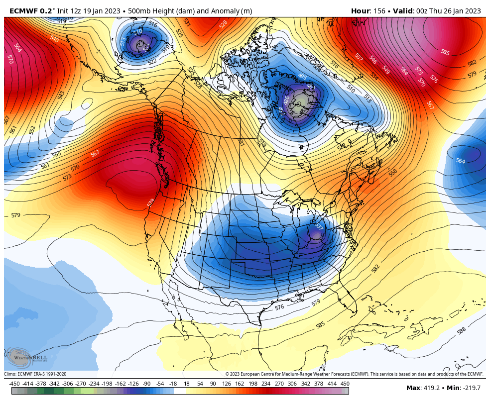
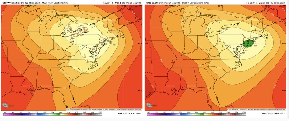
A big key to how this sets up going forward will be the positioning of the ridge in the West and/or East Pac… something that should be noted as definitely not set in stone as one can see from the 12z comparison of Op models. Funny part about this is the 12z GFS (on the right) in this hour timeframe is delivering C-PA snow from that 2nd potential system thats been showing up near the 22nd-23rd. I think that one probably has a better chance at frozen than the 19th/20th system although I wouldn’t sleep on that one either. At any rate, GEFS generally supports its op focusing the trough in the west while the Canadian op (maxed at h240) is more similar to the GFS today. The other ensembles of the Canadian and now the Euro EPS generally show the overall trough moves out instead of digging into the SW US. The latter two are definitely good looks, as is the Euro op itself. The temps still aren’t especially cold which I’ve brought up in previous posts and I’m sure has been mentioned elsewhere. Even with that Euro trough in the D8-10, negative departures aren’t that crazy and they’re more in the south than at this latitude while Canada is really warm wrt average. Even if this pattern evolves favorably following the 19/20th system, it’s likely not going to have anything crazy cold wise initially. It would still be plenty workable in our region though for snow potential given the time of the year. Unfortunately for @Voyager, the only really sure thing does seem to be temp departures in the SW US. 10 day average temps from D5-15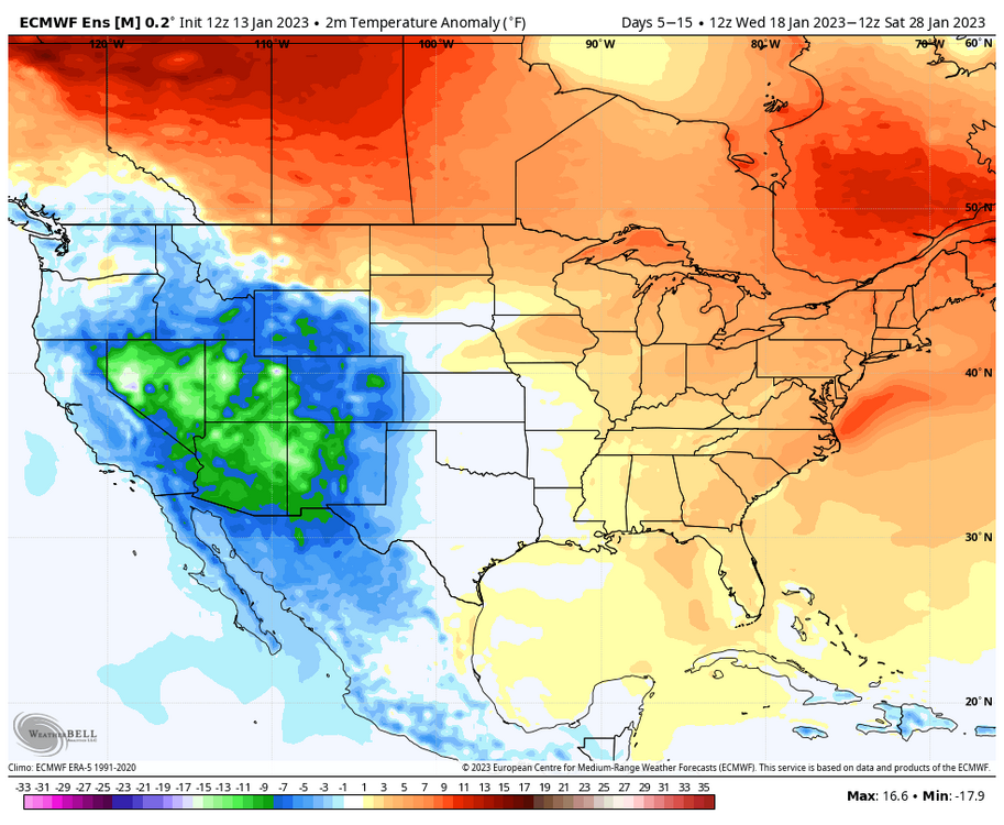
-
Central PA Winter 2022/2023
MAG5035 replied to Blizzard of 93's topic in Upstate New York/Pennsylvania
Op runs are going to waver greatly run to run out in that range but overall signal from all ensemble guidance has been persistently there for a reversal of the current regime to build a western ridge axis that goes up through AK, shutting off the onslaught of storms into California and developing an eastern trough.And they’ve been consistent doing that starting Jan 20th and after too (not pushing it back) as it’s gotten more in more into range with Jan 20th basically being at D10 now. Teleconnection forecasts have been running pretty positive EPO (-PNA) D5-10 and then reversing to neutral/negative D10-15. AO remains negative and NAO trends neutral/negative. 12z GEFS vs Euro EPS D5-10 comparison (using 5 day avg 500mb anomalies) 12z GEFS/Euro EPS D10-15 (5 day avg 500mb anomalies) If I threw the Canadian ensemble in there too it’s basically right in line with the GEFS/Euro EPS. It’s the kind of major shift we’ve been looking for in the Pac. That time in late January is the bottom of the curve in terms of climo temp wise so while winter’s been a bummer so far, it looks like we’ll be setting up a period of potential at a good time. Extended stuff like the Euro weeklies take this general pattern into early-mid February (the actual primetime Mid-Atl snowstorm season). So I’m confident this change does happen, but what will be interesting to see is how long of a period of opportunity we have….Is it like a 10-14 day window or can we actually get a more extended period? That may eventually depend on factors like the MJO and if it continues to do a 4-6 run after it’s currently forecasted run through a few of the colder phases (mainly 1-2 for now). -
Central PA Winter 2022/2023
MAG5035 replied to Blizzard of 93's topic in Upstate New York/Pennsylvania
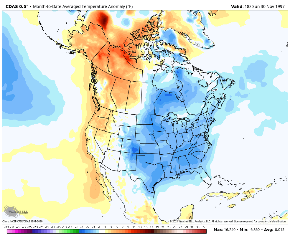
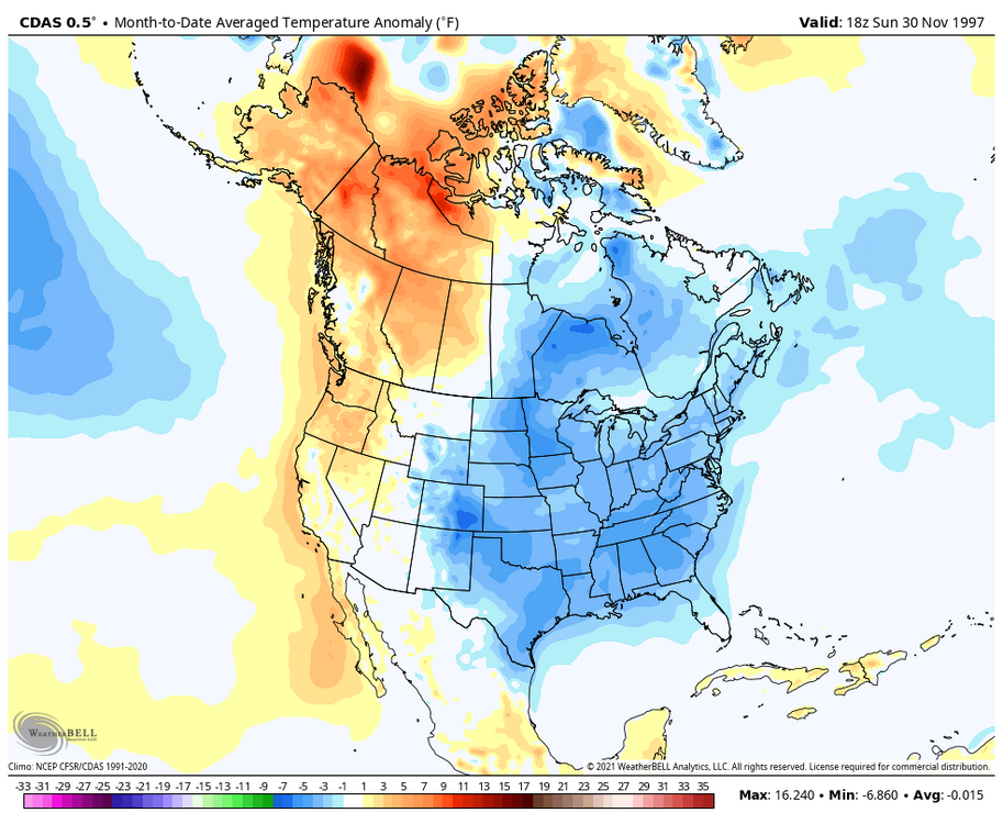
I’ll agree with the first sentence of that, the last couple weeks haven’t exactly been a standard boilerplate Nina in the west. As for the rest of that, there’s likely a Nino coming next winter but obviously predicting eventual magnitude/impacts in the eastern US at this point is a “hot” take at best at a point in the current winter where I’d likely consider saying something like the rest of the winter will definitely be a blowtorch in the eastern US a hot take also. Also, I dunno where he’s from or when deer season is there but my first year hunting when I turned 12 was Fall 1998 and it still is the warmest weather I’ve ever hunted in for rifle season. That was the December like the whole first week was in the 70s. So problem with his anecdote was he was probably talking December 98, which was during the start of the big Nina period of that timeframe lol. If he’s talking Nov/Dec 97 (during the actual super nino period) I dunno where he’d be hunting deer in shorts at.
-
Central PA Winter 2022/2023
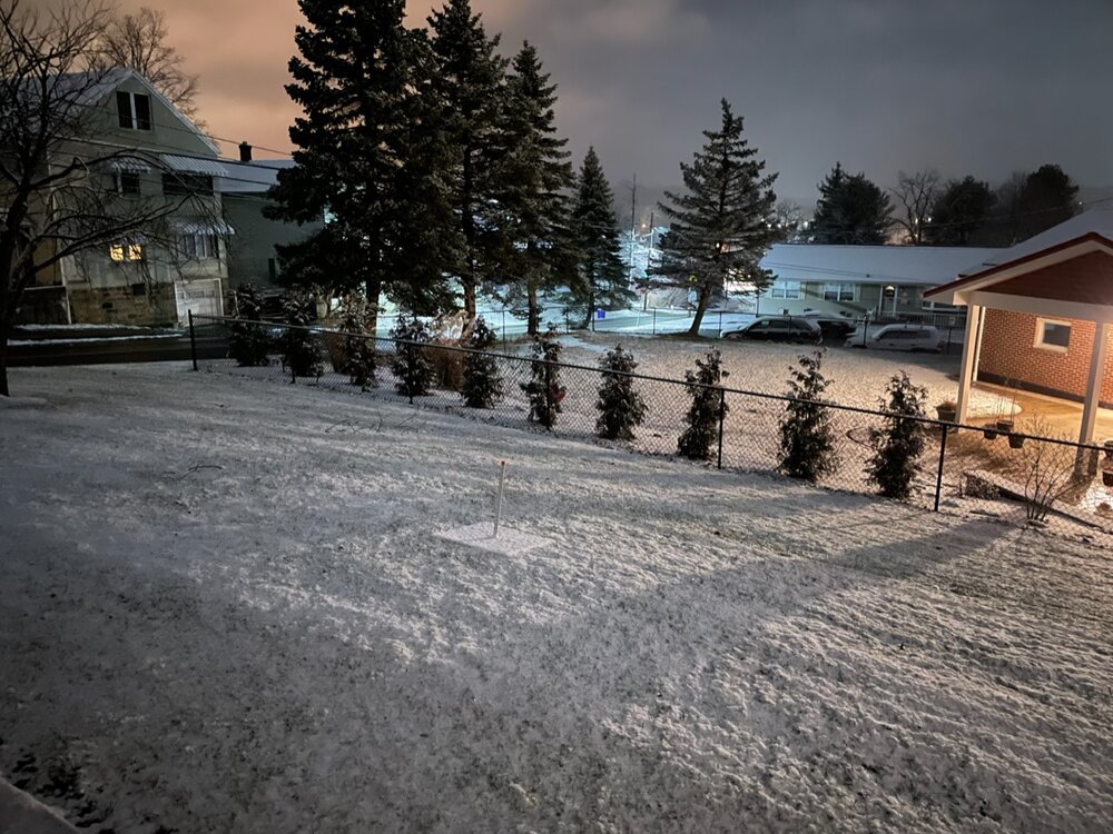
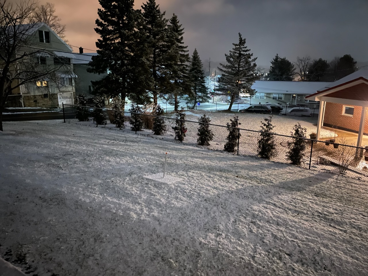
MAG5035 replied to Blizzard of 93's topic in Upstate New York/Pennsylvania
Back edge is here, managed a healthy 0.7” haha. Nice to see it white again though. 511cams showing it snowing pretty decent in most of Harrisburg now.