

SnowDawg
-
Posts
1,070 -
Joined
-
Last visited
Content Type
Profiles
Blogs
Forums
American Weather
Media Demo
Store
Gallery
Posts posted by SnowDawg
-
-
I think I have seen a tweet from some met in the last couple months saying that the Euro AI was bad with surface depictions, but was scoring well on large scale setups, but I can't remember now who it was.
-
 1
1
-
 1
1
-
-
If this thing is gonna be amped up, it's all gonna come down to how the 50/50 trends. Confluence will be our friend here both on track and thermals. Without it we need to go back to the weak overunning looks from yesterday afternoon.
-
1
-
-
Never thought I'd be jealous of a few stray snow showers, yet here we are lol. Still only a few tiny pin-flake flurries for me since 2022.
-
1
-
-
Despite the largely missed phase the baja low is still helping us out by setting up a moisture feed off the pacific. This may honestly be the look to pull for, with less chances of failure.
-
 1
1
-
-
1 minute ago, GaWx said:
Furthermore, for the SE and especially compared to the last few years, is that really all that light? 0.5-1.5” over a pretty large area
True true. I suppose it largely depends where you live and what you're used to. Despite the near 3 year drought, at nearly 2000 foot elevation I still see anything under 2 inches or so as light. Maybe time for new expectations though...
-
1
-
-
Phase almost entirely missed but still just enough energy to briefly inject some gulf moisture. The northern stream didn't really dig SW which made the cold press a little more direct into the SE. My guess is that the only path to bigger snow without temp issues is for the baja low to come east and meet the northern stream, not vice versa like 12z showed. If it digs hard SW then a brief ridge tries to pop in the east and we warm. That being said, I'd happily take a widespread light snow as shown.
-
2
-
-
Though nothing to write home about that EPS run was actually a small improvement from 0z. We've really just sort of waffled back and forth with the handling of the baja/northern stream interaction over the last 48 hours or so.
-
1
-
-
21 minutes ago, GaWx said:
The storm you may be getting could very well be a plain rainstorm per model trends. A strung out mess would be far more interesting to me (like 12Z Icon actually) at this stage than an amped up too far north rainstorm.
It is what it is. It is already predetermined what will occur but the models aren’t smart enough to know, which makes for interesting drama. I’d hate for the models to know in advance. Then there’s be nothing to discuss and debate forecasting wise.
Yeah that's definitely on the table. I think it was Eric Webb that was saying this setup is sort of big amped up storm, or squashed all the way into the Gulf, with very little in between. And when it comes down to those two scenarios, well we are unfortunately forced into a my backyard contest. Something like the Icon just means sunny, cold, and windy for me. While a GFS solution is close to a classic I-85N winter storm, with the admitted thermal risks. Just the unfortunate reality of the geographics of this board, systems that make us all happy are practically once in a lifetime events.
-
1
-
1
-
-
Block and 50/50 have trended weaker on the GFS. But admittedly, some of that weakening may be responsible for us having a storm at all and not a suppressed strung out mess. Gonna have to strike a balance between giving our wave room to amplify but not invite too much ridging in front of it wrecking thermals.
-
I'm not gonna overly fuss about p-types until we actually have a storm in hi-res model range. Right now close is close enough for me. Let's actually get that snow pack on the ground to our north, and see how the models adjust.
-
2
-
-
EPS looks much better than the GEFS. Even shows a low pressure anomaly in the northern gulf.
-
1
-
-
Op euro with another tick towards the GFS. GFS just had a slightly better attempt at the phase so it was a bit stronger. Like having op euro at least somewhat onboard for sure though.
-
Ensemble still just doesn't seem to really like it. As I said before I think it's possible they are a bit too coarse to solve the situation with the three different pieces of energy at this lead, especially the baja low maybe they are lagging behind the OP in seeing it tick east. Hopefully we see things change in the coming days, but have to be cautious until the ensemble shows support.
-
Just glancing at soundings and again the ice is a bit overdone
-
So close to more, phase was just a little too messy so it lost some oomph as it got into the northern gulf.
-
31 minutes ago, BooneWX said:

We’ll know early on the runs at 0Z if we’re on the right path or not. I wouldn’t fret what the surface depiction is. Our trough at 12z was pointed towards Montana and in the 18z runs, it’s climbing towards Seattle. That subtle shift kept the energy from going SW and let it get picked up by our trough.Taller ridge also makes the northern stream energy dig harder, making a phase more likely. Normally I would say this could quickly trend to too much of a good thing and it could end up wanting to cut, but the blocking and 50/50 confluence over the top should largely prevent that.
-
1
-
-
Love the look, think if it were to come to pass it'd be more widespread snow/sleet and not as much ice as it was showing but far too early to sweat p-types at this point. Hopefully we start to see some ensemble convergence on the handling of the energy in the SW.
-
2
-
-
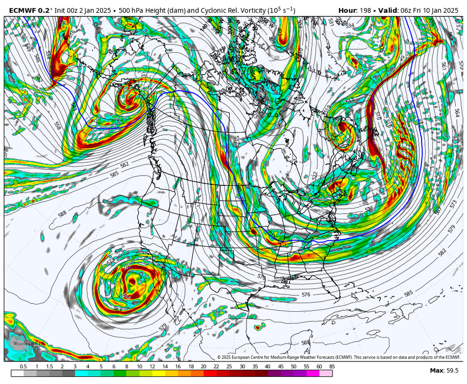
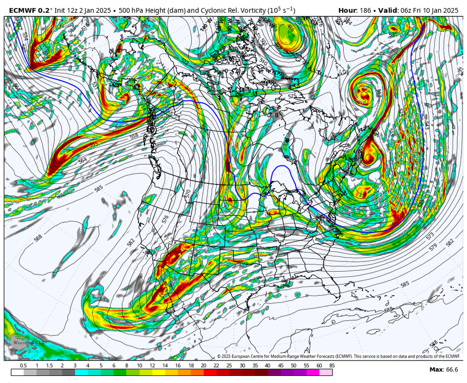
22 minutes ago, olafminesaw said:
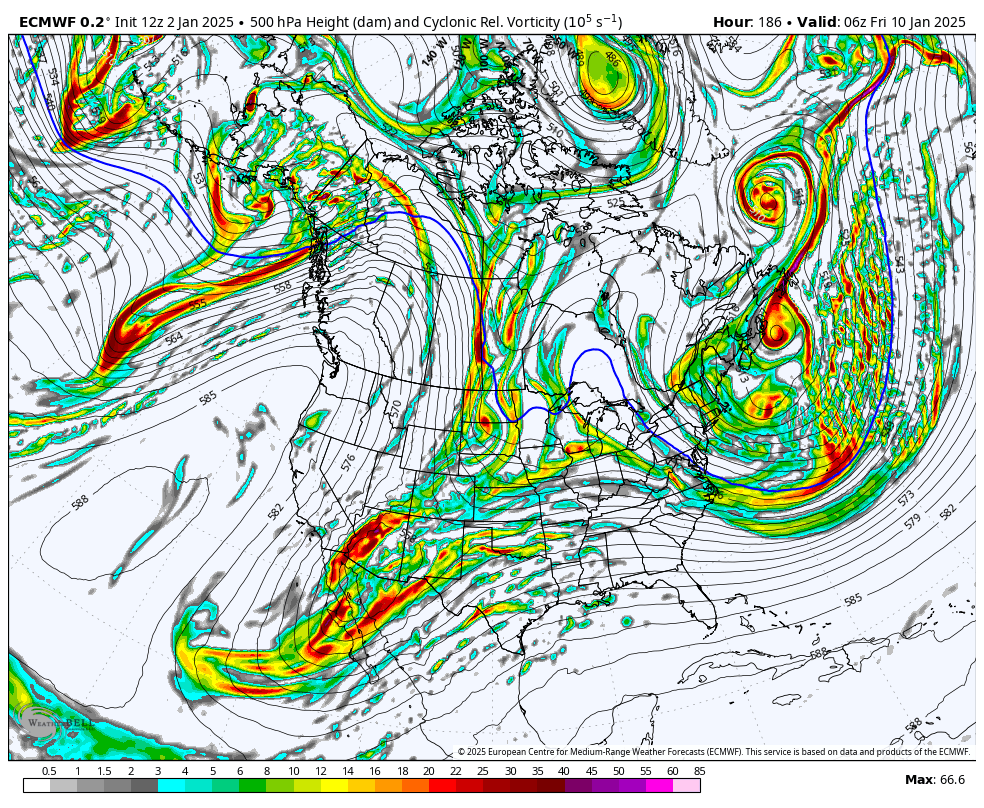
Can you show what you're seeing on the H5 between 0z and 12z. Seemed relatively similar to me, but I struggle when I get away from surface maps
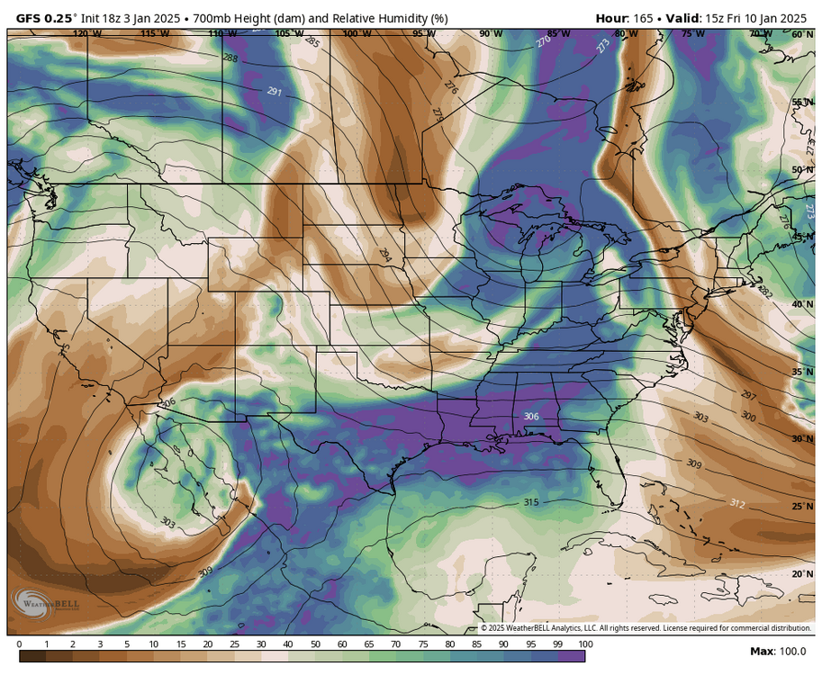
So looking at the 500mbar vorticity maps so we can see our pieces of energy, notice how unlike at 0z last night the Euro is not taking that big SW cutoff out into the pacific. At the same time our northern energy is digging further SW and attempting to phase. It ultimately fails, but it's a step in the right direction. (0z followed by new 12z)
-
1
-
1
-
-
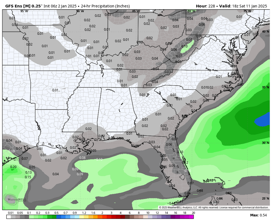
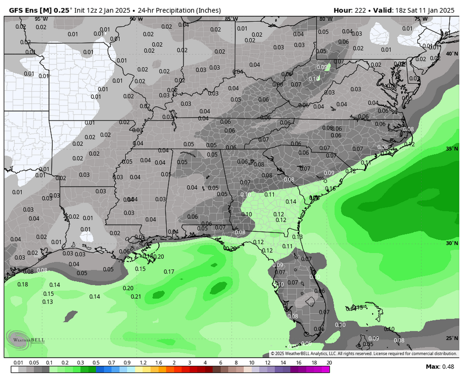 Pretty substantial increase in QPF for the 10th/11th on the GEFS. Let's see if we can get this to continue trending this direction. Also fwiw, the Euro made a big jump towards the GFS with the handling of the SW energy.
-
3
-
1
-
-
That Miller A threat is still close on razor thin margins, it'll all come down to exactly how all three pieces of energy interact with one another. And frankly at this lead, the ensembles may be a little too coarse in their resolution to lean on. Just need to wait it out, but acknowledge cold/dry is the easier outcome to get.
Side note as I'm just looking at it, but selfishly I'd take the 6z GFS in a heartbeat.
-
1
-
-
7 minutes ago, GaWx said:
If the 1/10-1 Miller A were to not return, I’d consider it a classic case of can kicking unlike 1/6. I don’t like the trends at all but it’s still early enough for the trend to reverse and 1/10-1 to return as it has been only 12 hours on the GFS among others and that’s still 8 days away.
Agreed, and at least grand scale all the pieces were still there they just missed connecting by very small margins. Funny how at 12z we got the fantasy run but the GEFS got worse, but tonight the OP misses and the ensemble actually improved marginally.
-
1
-
1
-
-
GFS much closer to the 12z run than 18z. Just a bit too much interaction with the cutoff energy in the SW caused the phase to just miss.
-
Close enough. Storm signal is still there. Not much else to takeaway at this point. Just playing the waiting game for now.
-
Honestly the GEFS wasn't all that enthused either, at least in comparison to the OP. Still looks very suppressed. But still showing multiple threats 9-15 so on to the next run I guess.


Mid to long range discussion- 2025
in Southeastern States
Posted
This storm up north trended south the last couple days after trending north before, maybe we can get the same luck. Also is showing a bit of CAD which one can hope is under-modeled at the time.