

SnowDawg
-
Posts
902 -
Joined
-
Last visited
Content Type
Profiles
Blogs
Forums
American Weather
Media Demo
Store
Gallery
Posts posted by SnowDawg
-
-
Well at least this winter is proof that we can still get Miller A's. This is like the 4th one. Of course they've all been warm rain storms...but beggars can't be choosers I guess lol
-
 1
1
-
 2
2
-
 1
1
-
-
I've said it all winter, this is the most La Niña looking El Niño I've ever seen. It's just an endless onslaught of low pressures rolling through southern Canada into the NE, meaning we can never build any decent HP to work with. Overactive northern stream, classic hallmark of a La Niña. It's like after the 3 year Niña some features are lagging to adjust.
It took 48 hours to go from this...
to this...

-
1
-
1
-
1
-
-
Knew a run like that would happen eventually. There's been plenty of members like that in the ensemble the whole time. We've been slow and steady losing the PNA on modeling for a while now, that's critical for our cold air delivery. Is what it is unfortunately. This multi year trend of the pacific always screwing us is just unrelenting. I just don't see a way out of it, and next year's La Niña will only serve to keep that pattern rolling. Math says climo favored areas luck into something eventually, and who knows maybe this is still the one, but extended winter weather appears a thing of the past until something can break this pacific regime we've found ourselves in.
-
 1
1
-
-
Verbatim I got blanked there, but I'd take that look and bet on CAD being a bit better.
-
If that dang pacific trough would back off and quit nudging into the west coast we'd be in business big time and not have so many sticking points in the forecast that could go wrong. Seems a proper PNA ridge continues to just be impossible to come by like it has been for years now. Lack of snow has not been surprising given that fact. To me it's the most important factor because it encourages the northern stream to dig hard.
-
3
-
-
Just need that to amplify sooner and that's a proper region wide slider. You can see how when it finally strengthens off the coast it pulls cold air into the system. Timing moved a bit towards the GFS, still think a slower southern wave is better for us but I'm sure it's gonna bounce around a bit for now.
-
2
-
-
16 minutes ago, jpbart said:
Living smack dab in the middle of SC. I am curious about how the gap between potential snow fall locations. This kind of snow event is especially frustrating to those of us in the middle of the gap. Anybody care to enlighten us forever snowless folks?
It is essentiallly two separate systems, one diving in from the northern stream and one sliding through the gulf. To fill the gap you need the two to phase. If it does it'll go boom, but miss the phase and the northern stream energy simply squashes our gulf wave, thus suppression.
-
1
-
 1
1
-
-
22 minutes ago, olafminesaw said:
Last night's EPS had like 3-4 waves it's trying to resolve. Kinda a good thing because with a big amped up storm we always flip to rain/ice. Moisture riding the boundary is our path to a big storm as yesterday's 12z GFS depicted. Having to rely on a well timed phase does make me nervous, but that's just winter in the South
Yep, that's why selfishly I would prefer the Euro solution to avoid the phase problem alltogther. But I know that does little good for anyone outside of CAD areas. Normally I'd feel bad for the lowland crew that regularly go years without snow and pull for a big boardwide monster storm, but after the longest snow drought in my life I'll admit I don't care what happens as long as I see snow lol
-
1
-
1
-
-
That northern vort being stretched and strung out over the top will never work.

A piece of it needs to dig and phase, like the GFS was showing yesterday or it needs to do what the Euro did last night and let the northern piece swing through ahead of our wave.
This lowers heights in front of the storm and let's our CAD high anchor in, and gives the stj wave more room to amplify some. The GFS and Euro are way apart on the timing of the southern wave with the GFS being over 24 hours faster. They may even be keying in on different pieces of energy. Long ways to go...
-
4
-
1
-
-
If I had to pick a preferred solution it'd definitely be the Euro. It removes the phase from the equation, let's that northern stream energy clear the playing field for a perfectly timed CAD high. A much simpler solution with less bust potential. Too bad there's still so long to go lol
-
1
-
-
GFS is proof this doesn't work without the phase. If we can't just get rid of that northern piece alltogther, then we have to get at least a partial phase. Otherwise it hanging out overtop leads to that disjointed look, with one low in the gulf and another in the lakes/Ohio valley wrecking our thermals.
As we already knew from the GEFS this was in the range of possible outcomes. Key will be seeing which scenario the ensembles start to converge around over the next few days.
-
1
-
-
That northern stream piece diving down is what's wrapping the cold air in to the storm. Phased a little later this run, thus less coverage on the snow. Ideally it'd happen even a little quicker than the 12z run.
-
There is a lot of support for a storm system in that time period it's just right now there's a mixed bag between wintry members, missed phases, and suppression. With the latter being the most favored at the moment. Given the likely need for at least partial phasing for this to work, unlikely to see stable solutions at this long of a lead time.
-
1
-
-
If that phase could happen just a bit quicker/further west it would've been all snow from the beginning, instead of the rain to snow look. All unimportant details at this range though. Now I'd like to see a significant number of ensemble members start to solidify around a single threat.
-
4 minutes ago, NorthHillsWx said:
If anyone’s wondering how we fail to this level with the PD storm, thank that strong GL low preceding the system that nukes thermals all the way to Maine
That and a whole lot more. Big changes all over the map by like hour 120. Run to run variability is nothing new though. Stick with the ensembles past 5 days.
-
3
-
-
25 minutes ago, wncsnow said:
If we can pull out a 2 week stretch like February 2015 I think a lot of us 40 north folks would be happy. That winter was pretty boring until late and was an El Nino.
Still one of my favorite winter weather periods in the last 10 years. Heavy Sleet/ZR storm on the 16th. Then back to back snows less than 10 days later.
-
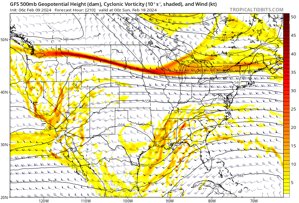
That pesky low in the lakes look we've seen a million times in the last two years. Need that northern stream energy to either dig a lot more SW and phase with our system, or just not be there at all and allow the highs to bridge over the top and give us more of a CAD look out front.
-
3
-
-
I have little doubt that we get a colder pattern with a few chances, but I'm not overly optimistic at this point in getting a good board wide system. Looks like a lot of late phasing messes, or missed phase suppressed southern stream waves. Maybe the NAO isn't being felt enough, and if the flow backs up a better phase could happen.
-
Confluence from the 50/50 will be key. We need an amped slow moving 50/50 in the right spot to help enhance our HP. Can at least hope this is a case of undermodeled CAD, and in the short range our HP and confluence will improve.
-
1
-
-
This setup for the 4th-6th is an extreme setup with high end snowfall potential forum wide, but it's also a very touchy one. Could be a situation of either a big winter storm or nothing at all, with very little in between.
-
3
-
1
-
1
-
-
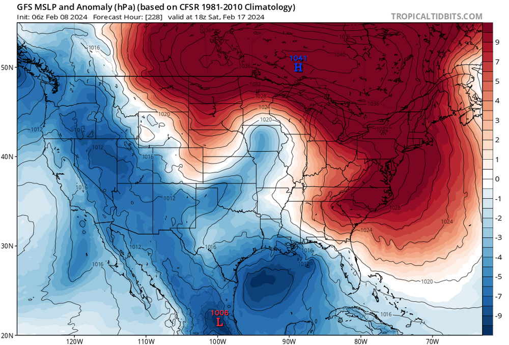
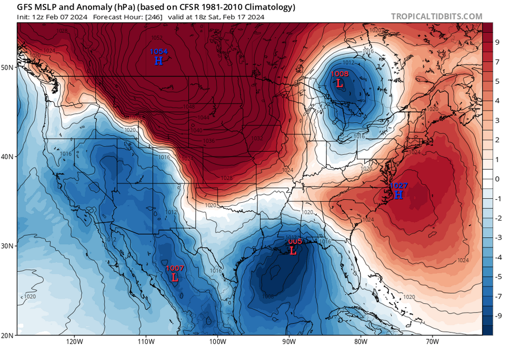
6z developed a nice stout PNA ridge near the end in response to the Aleutian low. And 12z has a trough stuck west of the Rockies with a central pacific ridge. Fantasy land so it doesn't matter but it at least shows us the features we need to be looking for. Decent north Atlantic blocking looks like a given, but as always which way will the pacific go?
-
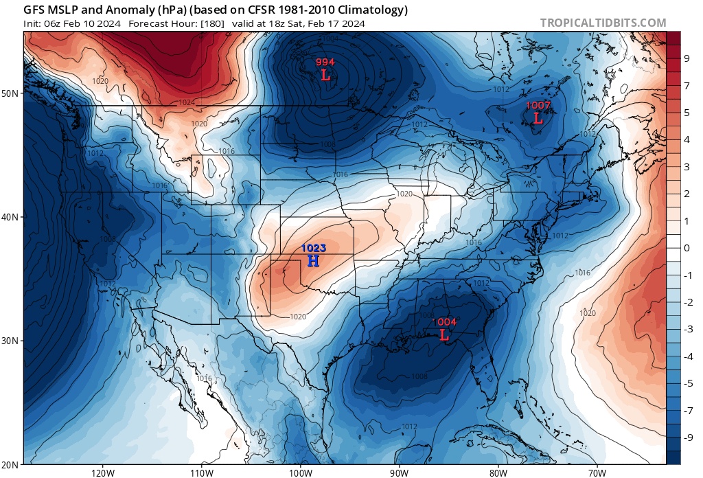
Could it be? High pressures and southern storm systems moving in tandem? The last couple years had me thinking that low in the lakes was a permanent feature lol
-
1
-
-
Yeah nice day here. 48 and partly sunny at times. Front just refusing to budge.
-
Looks like I won the overnight torch-off. Went to sleep at 33 with light virga overhead, woke up to 44 and drizzle. Still rising and up above 45 now.


Mid to Long Range Discussion ~ 2024
in Southeastern States
Posted
Gosh, now Tennessee is about to pull a rabbit out of the hat again. I swear I've never seen that region get as much snow as they've got the last couple years. Just unreal, the rich get richer.