

STILL N OF PIKE
-
Posts
14,841 -
Joined
-
Last visited
Content Type
Profiles
Blogs
Forums
American Weather
Media Demo
Store
Gallery
Posts posted by STILL N OF PIKE
-
-
21 minutes ago, HoarfrostHubb said:
I'm hoping for some lift early on. Make hay from 7-11PM. Pingers commence after midnight. Hoping the rain holds off.
Not expecting much at the end
I believe you are right about pingers but you ain’t goin above 34 degrees so ...
-
14 minutes ago, wxsniss said:
I think some spots northern MA have a shot. Euro has been steady with that area north of Worcester to NH border and another jack western MA.
I'm expecting sleet changeover in Boston metro - pike region around 12am (areas close to water contending with coastal front may get slop sooner, but I see that as a different process from the sleet line), and closer to NH border flips by 3-4am.
Heaviest rates of mostly snow in Boston metro 10pm-12am.
In my experience the sleet line moves from Boston to Nashua in about an hr or less 75% of the time when the warm tongue is the culprit
maybe this is a situation where it will be different ?
-
 1
1
-
-
1 minute ago, Bostonseminole said:
Had sex with my wife at 4:30 am, her pond was a bit frozen also
Sent from my SM-G965U using Tapatalk
Hitachi
19f Nashua
-
 1
1
-
-
8 minutes ago, CoastalWx said:
Just the wording. General 1-3 with 4 or a hair more interior MA north of pike.
Easton-Sharon-Walpole Jack?
warm tongue at 750 is changing everyone over by 1am , no?
unless the warmth at md levels holds off longer for NE mass (not just by 30-45 it takes to go from PVD to BVY)
-
6 minutes ago, CoastalWx said:
?? Just stating they cut back. Thinking 1-3 there and 1-2 here hopefully.
All I see is the map from 345pm yesterday ?
-
7 minutes ago, dendrite said:
Just saying what it showed. That isn't a snow growth issue after 6z...it's a nucleation one. CAD isn't saving anyone at 650-700mb. Hopefully the NAM is just too warm, but it doesn't really matter as there will be good snow with the initial thump anyway.
Usually the nam leads the way with the mid level warmth. Better dump between 9 and 12-1am
-
50 minutes ago, JC-CT said:
Why
Was jokin
-
1 minute ago, ineedsnow said:
But they increased the upper end.. which you think would go lower if the expected snowfall did..

High stakes in ORH county
Big lift or big 2”
-
6 minutes ago, weathafella said:

Toss
-
1 minute ago, CoastalWx said:
The upper level low goes over us, so it looks a bit further north this morning.
Ya I mean when KEV says “ south of Long Island “ and doesn’t post a map, we kno where it’s tracking
-
Just now, CoastalWx said:
Well time the reel the weenies in. I don’t see winter storm warnings for all interior, and the flashback is up north. But should be a fun first event.
How far north
-
1 hour ago, H2Otown_WX said:
Yeah everything is a few hours faster which helps. It brings in precip to SW CT around 11AM. Definitely looks like a shot at warning criteria even south of the Pike if it were to play out that way. Really dumps for about 5-6 hours before it gets too warm aloft.
Does the thump stay strong N of pike
-
2 hours ago, Blizz said:

Seems like 11/10 you go under on the euro clown maps. Wish they were never a thing
2-4” looks good
-
3 minutes ago, ORH_wxman said:
Even just a steady 3/4 vis light snow for several hours will put down 2" in this airmass off the coast.
Really , well then thank you. That’s crucial info imo
-
9 minutes ago, Chrisrotary12 said:
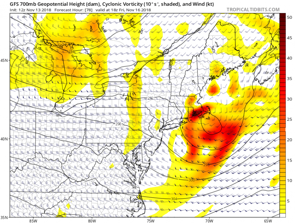
Slightly worried about this one in that the initial LP gets captured and tucked to Atlantic City. And in doing so the best WAA doesn't make it into SNE. For example, check the 6-hr QPF at hours 66 v 72. Long Island and the south coast get upwards of 0.75" of liquid between 60-66, while SNE is significantly less (half) between 66-72.
By worried I mean: we see hours of light snows and drizzle that barely accumulate instead of hours of accumulating snows.
However, I'm very curious to see what happens as the system goes out underneath us (or over the Cape) Friday afternoon. I mean look at this thing.
Ya it seems to me that we see a few of our blown forecasts on ignoring indications of a mediciore thump in the initial WAA, especially when most sne accums would depend on that. Could go either way still but the point is it’s a flag that seems to be brushed off like it takes the fun of an event away to mention it . I would agree there is potential around and just outside 495 for part 2
-
1 hour ago, 40/70 Benchmark said:
I was going to leave wxbell for that, but figured I'd stay because I'm used to it, and I will end up divorced if I have access to 4 Euro runs daily.
Just don’t call her “Euro” you know when
-
1
-
-
2 minutes ago, CoastalWx said:
Your lat may help. I'd say 2-3 a decent bet. Maybe more if NAM or Canadian happen.
I’ve seen some models that wanna maximize that thump S of pike
-
1 hour ago, sbos_wx said:
As many here have confirmed, I don't see any type of miracle happening here near the coast. Should be toast, and I'm skeptical on measurable. Would consider a half inch a win if you're on immediate coastal plain. I'd think 1-3" inside 495. A general 3-6" outside 495. Perhaps 4-8" for higher elevations of SNE. You have onshore winds and discouraging mid level wind direction despite colder air in place. Wouldn't be surprised if this ends up being a warmer event tucked closer to LI, leaving most outside of higher elevations with lower totals. We need to keep an eye on how this trends in the next day or two.
I mean is it Mid November and we have a retreating high , starting in a good position but moving out.
It’s a fascinating system and I’m not gonna guess how it will play out but my Initial hunch is we in sne are gonna need a nice thumping to produce some front end snows for the interior coastal plain or we bust any amounts forecast
-
10 hours ago, powderfreak said:
Hoping for the first real plowable snowfall at home (3" or more) in the valley... the crusty coating around home looks like Dryslot's photo but would take the wintry vibe up a notch to really cover the ground up.
HRRR keeps us in the 3-6" type range. I think 3-4" on about 0.5" precip would be my best guess.
Looks like even 50% of New England could see snow out of this one, so getting more widespread with each event.

What a sneaky good pattern for the ski areas the last few weeks.
Synoptic storm after another has taken similar track and been juicy , and temps BN. At 1500’ and above most of NNE looks like winter
-
This has been trending colder and more of a net gainer for NNE on the nam and btv wrf, there is a more noticeable N drain all the way down to Nashua NH Tuesday am (very nill chance that effects precip may some pingers down here) but for Alex this looks mostly frozen to me and I believe Gene at 1100’? Or so should see another slushy couple by 8 am.
looks solid for The Cat as they approach 30” for season
-
Looks progressive thankfully, I believe SNH can get in on this one from Salem N and west
-
Over achiever
hoping next storm gets more ppl involved
-
1 hour ago, wxmanmitch said:
We snow. Moderate to at times heavy snow now. 32.5° F. Around 1/2" down.
Looks like down thru Savoy is cashing in
nice elevation snows for N and W , thou looks like you may flip later?
-
2 minutes ago, USCAPEWEATHERAF said:
I believe the RAINpack from this weekend's storm and next Tuesday's storm system will lay down a foundation for a much colder airmass to support the third storm coming up the East Coast.
Priceless


Nov 15/16 regionwide event
in New England
Posted
2-4” w a spot 5 looks to be a good forecast away from immediate ocean. Pretty much region wide, i see little reason to go higher near NH border
i could even see a case to go lower near NH border where mid levels move in faster than the precip shield moved hours earlier, but not getting that cute