

STILL N OF PIKE
-
Posts
14,848 -
Joined
-
Last visited
Content Type
Profiles
Blogs
Forums
American Weather
Media Demo
Store
Gallery
Posts posted by STILL N OF PIKE
-
-
3.0” on dot at noon for KBED area
27F
-
1 minute ago, jbenedet said:
That's valid but at max 0.5"/ hr tops. It's flurrying out right now.
Def underperforming thru noon there , I think you see good rates from 1-3pm (1”/hr) and well I guess we shall see if and when that sleet line finds resistance by then
-
My guess is flip in KBED by 130pm
just please stay below freezing
-
1 minute ago, jbenedet said:
I thought we respect NAM thermals.
That mix line is racing north now.
I figure you have 4 hours to go
-
2 minutes ago, weathafella said:
Big and many fatties. 3.4 as of a minute ago. Have a call at noon but will try to sneak a measurement of sleet gets here before 1. Sorry Ray- we exceeded your forecast.
Looks like it’s about at your door
-
Bedford , Ma is ripping now
26.5
going to take a measurement
-
4 minutes ago, The 4 Seasons said:
how much?
Did DIT measure ?
-
3 minutes ago, jbenedet said:
Expecting to underperform here. Guidance JP not panning out imby.
Dry air, and subsidence now, then turns to dry slot and 850 issues. Gonna put a hard cap on this at 3" tops...
Enjoy your 5”
-
 1
1
-
-
1 minute ago, WJX231 said:
Yeah definitely overperformed here in Seekonk. Gotta be at least 4" but it's changed to zr.
Rates over performed in SE mass and RI
-
1
-
-
Most know better than to toss Nam thermals
-
1
-
 1
1
-
-
18 minutes ago, met_fan said:
Wait…where is there an elevated “downtown” on the east slope of the Berks?
By downtown I don’t mean anything other than a small town “downtown” where there is a coffee shop, a tax guy, prolly an insurance office and a couple places to grab lunch or dinner . There must be a couple towns around 1500’ in Berks that meet that criteria
There are many of those on E side of monadnocks in NH
I would say Chester , Ma fits that bill..maybe Worthington , Ma
-
1
-
-
14 minutes ago, RUNNAWAYICEBERG said:
It’s been on the table between the wife and I. It’s not climate related but obviously I lean into it when I can.
Moving toward warmth or moving toward snowier pastures
Berkshires aren’t too far . Take her for a romantic dinner near tanglewood or wherever when folliage is popping , drop a cialis and make it memorable and when the kids are old enough move to East slope berks and save money since you won’t care about school systems , find a nice small elevated town with a nice small downtown where you can have dinner out that isn’t middle of nowhere and weenie out
-
1
-
-
Looks like there will be school bus issues (to me) for 495 corridor when kids try to get home around 230-3
I would think it would be wise for superintendents to have cancelled or do the rare early release outside 128
-
Pounding N and W of Warwick on the RI traffic cams
-
3 minutes ago, George001 said:
I’m going to disagree that temps haven’t been an issue. BOS finished Dec around +5 and Jan so far has been around +5 as well. That’s a bad pattern, it has been 5 weeks of garbage and a 1 week favorable window.
Temps have been an issue for the areas that have been porked . Inside 128 to 95 corridor and SE didn’t miss out on QPF the BL killed ‘em on the biggie that others got but it’s Been just serviceable enough N or W of 128
-
Looks gorgeous out
-
2
-
-
-
12 minutes ago, CoastalWx said:
Winter is brutal when it's 40 and rain for weeks. And personally I could use a good winter to soothe the soul.
Nearing 2 years without a 4" storm. This has been no different vs last year so far. Just sucks.
Can’t you plan 1 or two winter getaways to somewhere like lake Winnie or VT NH for school vaca or weekends or does nobody else care that you simply want to see some winter . Just take Bryce get a hotel and put him in ski lessons
-
6 minutes ago, Damage In Tolland said:
Models have this area NW of 84 as the line of mainly all snow vs ice later this afternoon. My guess is we go to zr for an hour or two and then back to snow. 84 always seems to be the battle zone
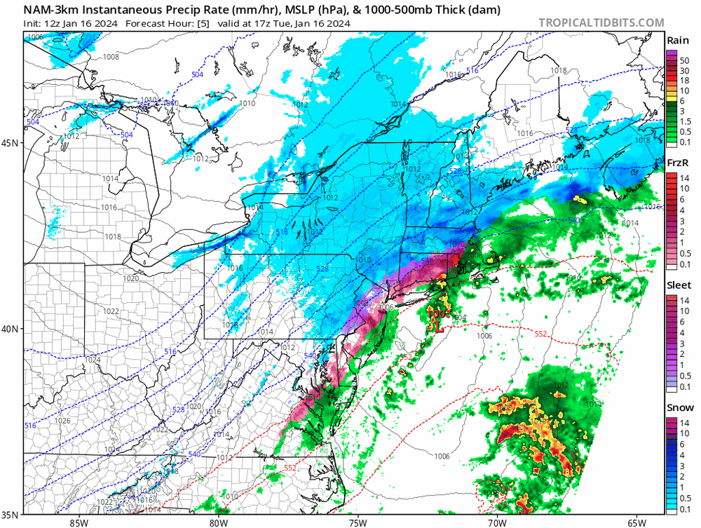
Nam nest 3k has 5 hours of sleet and ice for you
it makes a solid push N and W thru S SNE between 14z (now ) and 17z
14-15z push is mostly thru RI.. and adjacent SE mass and E CT . Including say Ginxy to Cory by 10am
-
My question is when do the milder temperatures aloft that dentrite mentioned move in that limit ratios and snow growth
-
This is the first time in last year and a half where Bedford Mass started a storm with powder snow and temps below 30F
-
7 minutes ago, RUNNAWAYICEBERG said:
Ray jack part 2.
Maybe if he moved nw 50 miles
looks like a nice 5” to maybe 6” spot for him
7-8” probably in Monads to Maine
-
1
-
-
Meso’s just kept ticking milder
West and N CT kept tickling sleetier and icier
Thankfully we had a good antecedent airmass
-
1
-
-
8 minutes ago, TauntonBlizzard2013 said:
Canadian was pretty close but the gfs took a large step back
To be honest this looks as close to a SE Mass special as anything in the last 2 years (which isn’t saying much ) but it’s finally cooooollld by the coast and the folks on the Cape that haven’t drank themselves into a stupor last cpl winters
-
 1
1
-

At least it's something - Jan 16th Snow/Sleet/Ice OBS Thread
in New England
Posted
Any idea what Garth got
3”?