

weatherextreme
-
Posts
540 -
Joined
-
Last visited
Content Type
Profiles
Blogs
Forums
American Weather
Media Demo
Store
Gallery
Posts posted by weatherextreme
-
-
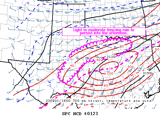
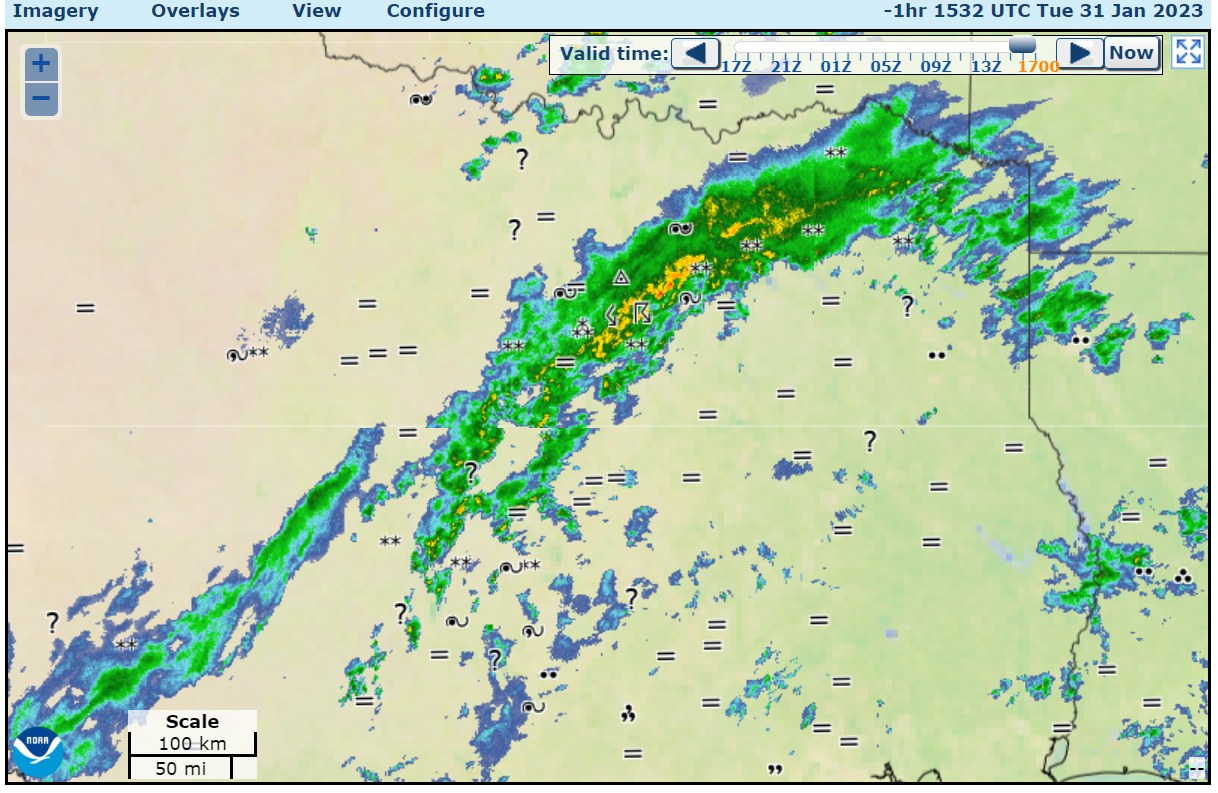
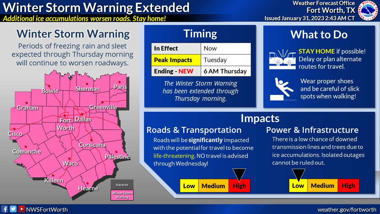
Mesoscale Discussion 0123
   NWS Storm Prediction Center Norman OK
   1135 AM CST Wed Feb 01 2023

   Areas affected...north-central Texas...northwest Texas...and
   portions of Southwest Texas

   Concerning...Freezing rain

   Valid 011735Z - 012130Z

   SUMMARY...Light to moderate freezing rain will persist into the
   afternoon from north-central Texas to near Abilene and east of
   Midland.

   DISCUSSION...A band of relatively concentrated precipitation has
   developed from west of San Angelo to northern Texas. This is forming
   in a zone of weak frontogenesis and warm air advection around 700mb.
   This will favor heavier precipitation rates in this corridor through
   the afternoon. The heaviest rates are expected by late afternoon as
   frontogenesis strengthens and focuses in this region. The last
   several HRRR runs suggest a mesoscale corridor of total QPF in
   excess of 0.75 inches. Observations this morning have shown a mix of
   sleet and freezing rain, but this is expected to transition to
   mostly freezing rain this afternoon as the cold air becomes more
   shallow. Icing is expected across most of this region with more
   significant icing possible where any banding can develop later this
   afternoon/evening.
-
2 minutes ago, vwgrrc said:
Denton CT falling pretty hard consistent with what radar shows.
Just south of Denton has warmed up into the mid 30's
-
Lots of reports that radar is showing freezing rain, but nothing hitting the ground. Do we know what's causing that and could it change ?
-
 1
1
-
-
-
-
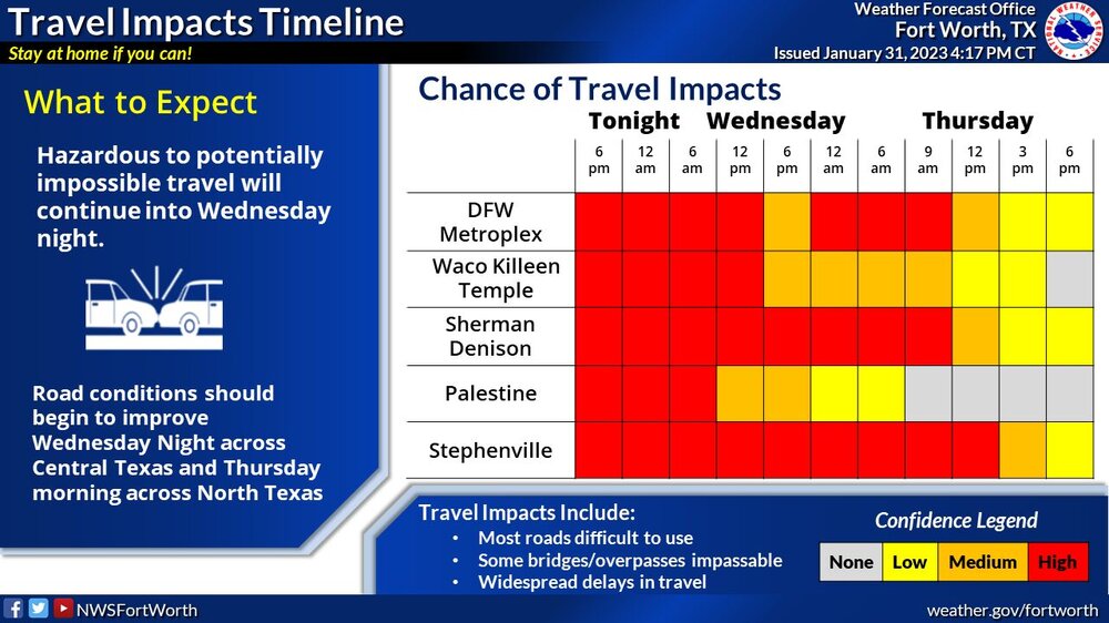
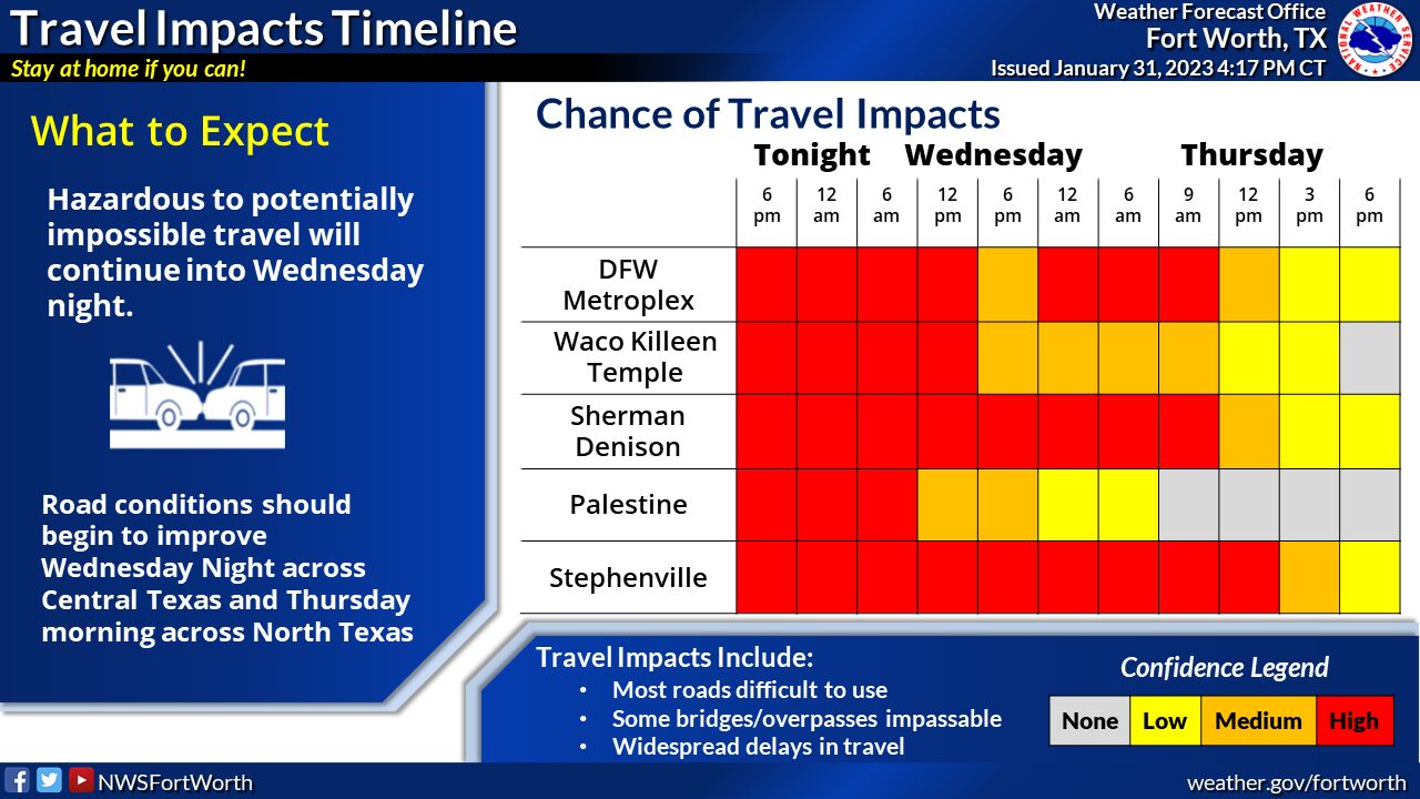
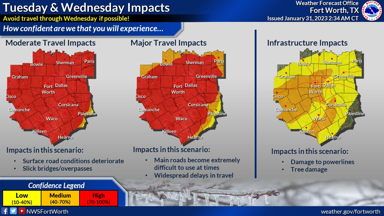
Travel Impact Timeline updated
-
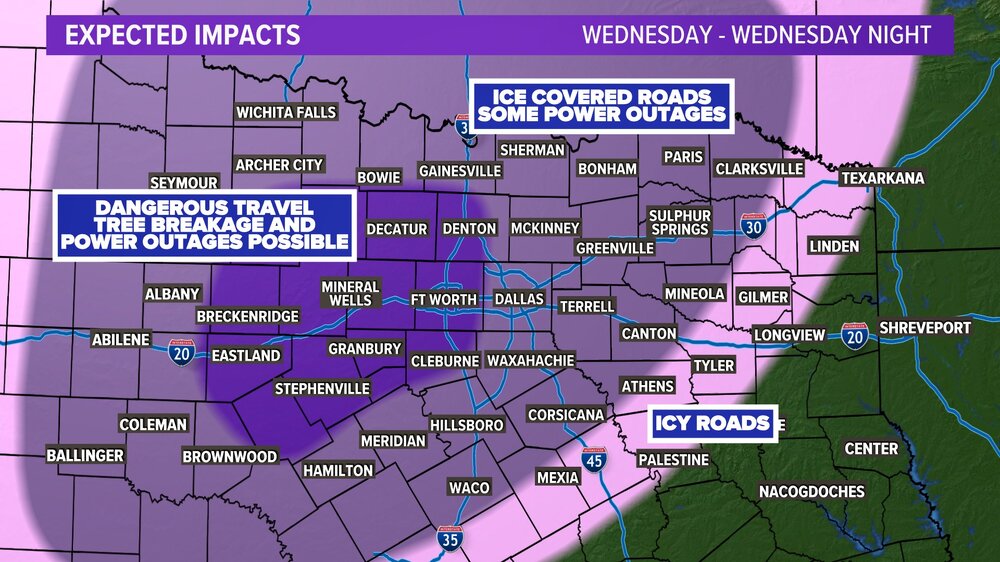 Today's primary precipitation type was sleet. Tomorrow, it's expected to be freezing rain. That's the most problematic type. Those under an ice storm warning will see the biggest impacts with possible power outages. #wfaaweather
 -
6 minutes ago, Chinook said:
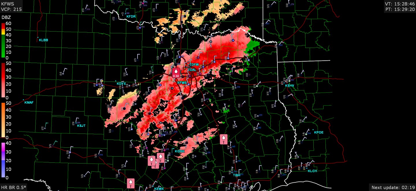
Fort Worth had 0.30" reported freezing rain. Other note: thunder recently reported at the Dallas area and also Poteau, OK (temps below freezing on both)


Does this mean that DFW is transitioning from sleet to ice?
-
-
-
-
Looks like the middle of DFW isn't getting much. It has been more West Dallas/Fort Worth/Denton) and some of the east locations.
-
-
-
-
If this system is producing during the early morning hours wondering what is going to happen come mid day/evening as it moves east. Towards the enhanced
-
TXC049-083-242230- /O.CON.KSJT.TO.W.0003.000000T0000Z-220524T2230Z/ Brown TX-Coleman TX- 515 PM CDT Tue May 24 2022 ...A TORNADO WARNING REMAINS IN EFFECT UNTIL 530 PM CDT FOR SOUTHWESTERN BROWN AND SOUTHEASTERN COLEMAN COUNTIES... At 514 PM CDT, a severe thunderstorm capable of producing a tornado was located near Trickham, moving east at 25 mph. HAZARD...Tornado and two inch hail. SOURCE...Radar indicated rotation. IMPACT...Flying debris will be dangerous to those caught without shelter. Mobile homes will be damaged or destroyed. Damage to roofs, windows, and vehicles will occur. Tree damage is likely. This dangerous storm will be near... Trickham around 520 PM CDT. -
-
Large tornado reported on channel 9
-
Funnel cloud reported on channel 9
-
Tornado on stream via helicopter
-
Tog confirmed by
-
-
Channel 9 just confirmed TOG

Texas/Oklahoma Discussion & Obs Thread 2022
in Central/Western States
Posted
South of Denton went back down to 27 from 34. That was pretty quick