

weatherextreme
-
Posts
540 -
Joined
-
Last visited
Content Type
Profiles
Blogs
Forums
American Weather
Media Demo
Store
Gallery
Posts posted by weatherextreme
-
-
Clipped footage
https://clips.twitch.tv/HilariousInnocentOrangeFrankerZ-DK7WjIGxf8dnxWgL
Some metal object in the middle of the road now (from the live stream)
-
-
This was just posted
He's on the Iowa storm
Think he has the tornado warned storm
-
-
Brad Arnold has/had a lowering on his stream (Per Ryan Hall)
-
-
New tornado warning for Little rock
-
-
-
 1
1
-
-
-
Tornado prob increased with slightly larger area
-
Thursday downgraded

-
-
Reed confirmed Tornado on stream
-
11:30 update


-
Loos like more severe for MS and other surrounding locations (Maybe we should extend this thread for this new threat?)
-
1
-
-
-
-
https://www.twitch.tv/agendafreetv
Major Tornado Damage in Rolling Fork, Mississippi - LIVE Breaking News Coverage
-
1
-
-
35 minutes ago, KoalaBeer said:
Reed has it.
Looks like he was cut off abruptly. They are saying something might have happened to Reed. (Not sure what happened)
-
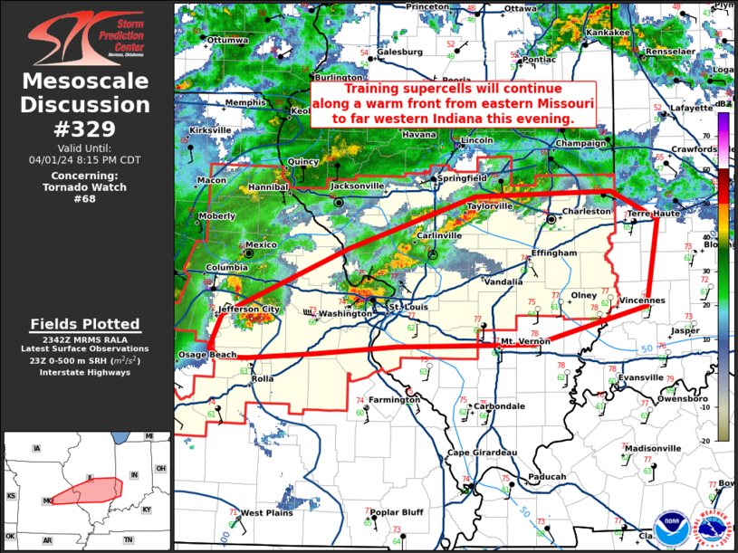
https://www.spc.noaa.gov/products/md/md0329.html
 Mesoscale Discussion 0329
   NWS Storm Prediction Center Norman OK
   0824 PM CDT Fri Mar 24 2023

   Areas affected...North-central MS

   Concerning...Tornado Watch 76...

   Valid 250124Z - 250215Z

   CORRECTED FOR ERROR IN SPATIAL DELINEATION

   The severe weather threat for Tornado Watch 76 continues.

   SUMMARY...An intense tornado (EF3+) is likely ongoing with a
   supercell tracking northeastward across western Sharkley County MS,
   and this storm should persist for the next 30-60 min.

   DISCUSSION...Latest radar data shows an organized cyclonic supercell
   tracking northeastward across western Sharkley County MS, with a
   VROT above 70 kt and well-defined TDS up to 13k ft -- indicative of
   an intense tornado (EF3+) given the parameter space (STP of 4). The
   downstream environment features a large, clockwise-curved hodograph
   per DGX VWP (around 430 m2/s2 0-1 km SRH) amid rich boundary-layer
   moisture. This will support the maintenance of this intense
   supercell toward the northeast for the next 30-60 min.

   ..Weinman.. 03/25/2023

   ...Please see www.spc.noaa.gov for graphic product...
-
This was posted on another forum. Looks nasty
-
1
-
-
20 minutes ago, Ed, snow and hurricane fan said:
Watch coming. 67F dewpoint at SPS.

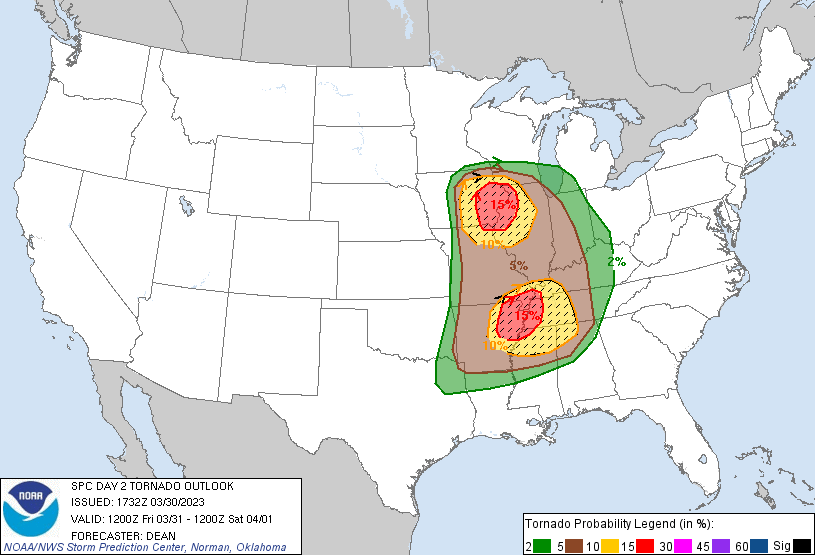
Any thoughts on the new graphic
-
3 hours ago, Normandy said:
Take it FWIW, but the system that will cause these events crashed into California yesterday and Monday….and in my 15 years living in Los Angeles it was the strongest system I’ve experienced. Some highlights:
- 102 mph wind gust in Valencia, CA
- confirmed tornado in Montebello, CA (strongest observed in the Los Angeles area since 1983). Rating still TBD but will likely be assigned an EF-0 or EF-1 based on damage produced
- several 60-90 mph wind gusts in San Francisco due to a bomb cyclone that developed at the center of the low pressure system
I got my eyes on this one
How rare is it for LA/Cali to get tornadoes?
Edit: Neverminded. Just noticed the mention of 1983.
That's pretty rare


Severe Weather 3-30-23 and 3-31-23
in Central/Western States
Posted
https://www.localmemphis.com/watch