

weatherextreme
-
Posts
540 -
Joined
-
Last visited
Content Type
Profiles
Blogs
Forums
American Weather
Media Demo
Store
Gallery
Posts posted by weatherextreme
-
-
-
-
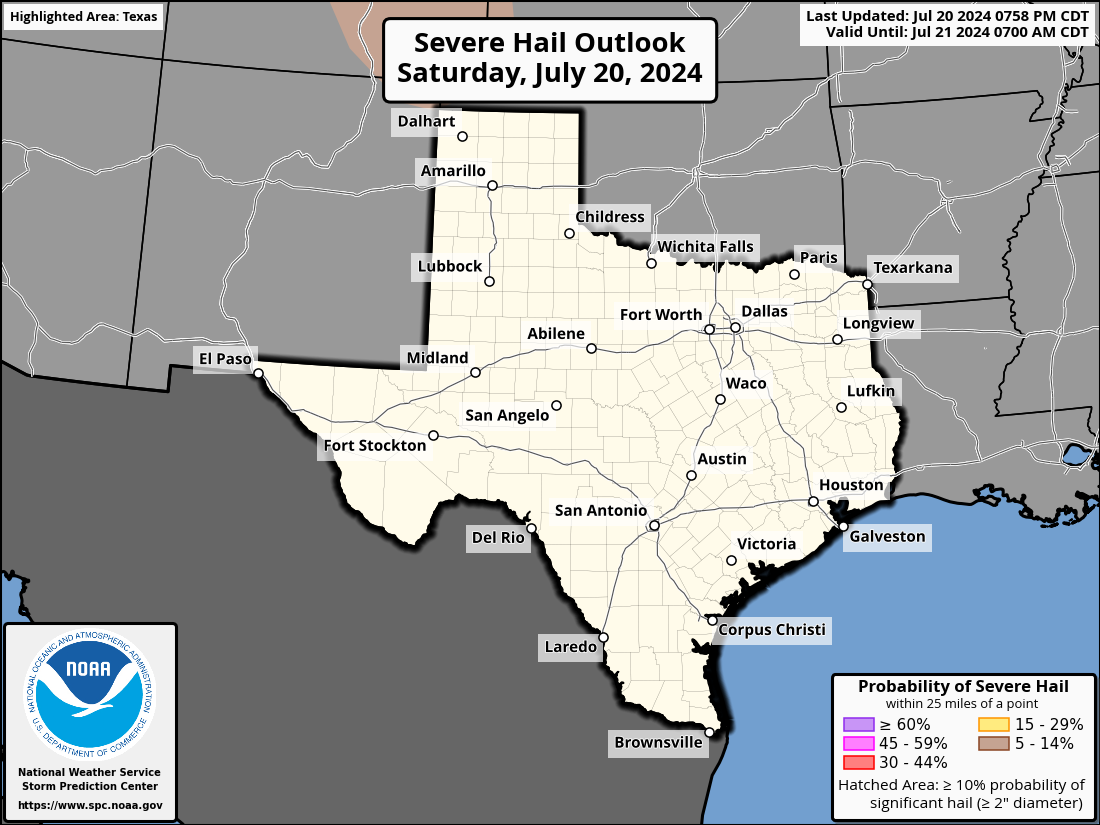
Southward shift in severe with the latest outlook (From DFW)


-
-
-
Brad might be on that same wall cloud
-
Jason Cooley stream showing some rotation
-
Reed following the storm out towards Abilene. On the boundary
-
DFW been taken out of the main threat zone. Shifted South


-
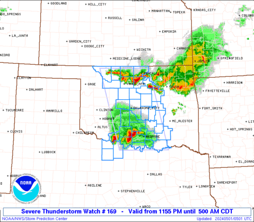
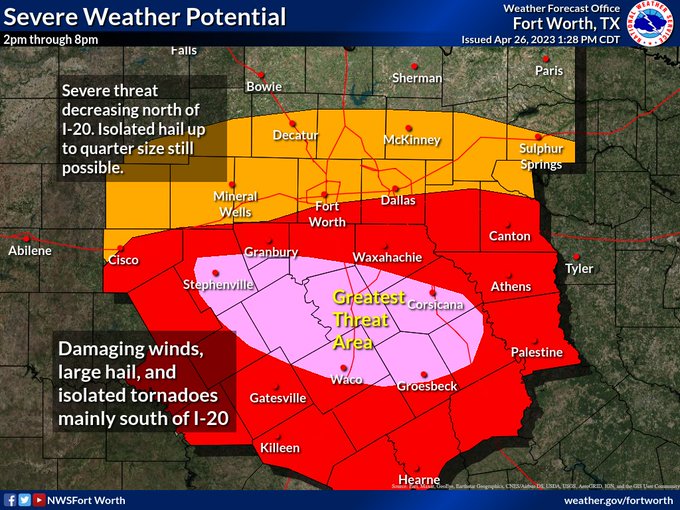
URGENT - IMMEDIATE BROADCAST REQUESTED Tornado Watch Number 169 NWS Storm Prediction Center Norman OK 250 PM CDT Wed Apr 26 2023 The NWS Storm Prediction Center has issued a * Tornado Watch for portions of Central Texas * Effective this Wednesday afternoon and evening from 250 PM until 1000 PM CDT. * Primary threats include... A few tornadoes likely with a couple intense tornadoes possible Widespread large hail and isolated very large hail events to 3.5 inches in diameter likely Scattered damaging winds likely with isolated significant gusts to 75 mph possible SUMMARY...Supercells capable of producing multiple tornadoes, very large hail, and damaging/severe winds are expected to develop and spread southeastward this afternoon and evening. Some of the tornadoes could be strong, and damaging winds will likely become a greater concern this evening as thunderstorms grow upscale into a bowing cluster. The tornado watch area is approximately along and 60 statute miles north and south of a line from 20 miles west southwest of Brownwood TX to 50 miles north of Huntsville TX. For a complete depiction of the watch see the associated watch outline update (WOUS64 KWNS WOU9). PRECAUTIONARY/PREPAREDNESS ACTIONS... REMEMBER...A Tornado Watch means conditions are favorable for tornadoes and severe thunderstorms in and close to the watch area. Persons in these areas should be on the lookout for threatening weather conditions and listen for later statements and possible warnings. && OTHER WATCH INFORMATION...CONTINUE...WW 168... AVIATION...Tornadoes and a few severe thunderstorms with hail surface and aloft to 3.5 inches. Extreme turbulence and surface wind gusts to 65 knots. A few cumulonimbi with maximum tops to 600. Mean storm motion vector 28035. -
-
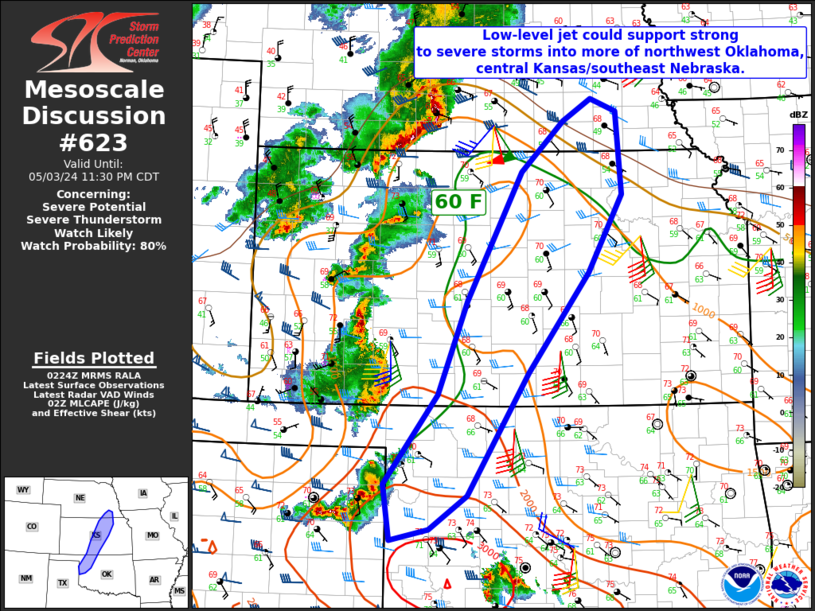
 Mesoscale Discussion 0623
   NWS Storm Prediction Center Norman OK
   0120 PM CDT Wed Apr 26 2023

   Areas affected...central TX

   Concerning...Severe potential...Tornado Watch likely

   Valid 261820Z - 262045Z

   Probability of Watch Issuance...95 percent

   SUMMARY...Convective initiation is forecast over central TX by mid
   afternoon coincident with the leading edge of ascent/cirrus nosing
   into the Big Country.  Additional storms may develop near the
   outflow/warm front intersection.

   DISCUSSION...Visible-satellite imagery shows a swelling cumulus
   field south of an outflow boundary and east of a dryline.  Surface
   temperatures have warmed into the lower 80s deg F with dewpoints in
   the mid 50s near San Angelo and upper 60s near the warm front.
   Forecast soundings show minimal convective inhibition remaining
   across central TX as the boundary layer continues to
   warm/destabilize.  Water-vapor imagery shows the leading edge of
   cirrus and implied ascent spreading quickly east across the Permian
   Basin and into the Big Country.  As a result, convective initiation
   is expected in the next hour or so near Abilene.  Once the remaining
   cap is breached, expecting explosive updraft growth with a hail risk
   quickly developing.  Effective shear 40-50 kt and MLCAPE in excess
   of 3000 J/kg will rapidly promote supercell development.  Large to
   giant hail (diameters 1 to 3+ inches) is expected.  A tornado risk
   will likely focus near the warm front where relatively backed
   low-level flow augmenting hodograph size, and surface
   temperature-dewpoint spreads are less than 20 deg will reside.  A
   strong tornado may occur if an established supercell(s) can interact
   favorably with the warm frontal zone.

   ..Smith/Gleason.. 04/26/2023
-
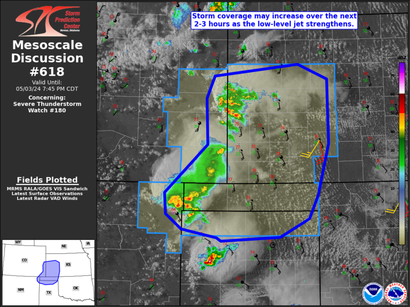
Mesoscale Discussion 0618
   NWS Storm Prediction Center Norman OK
   1118 PM CDT Tue Apr 25 2023

   Areas affected...North TX into far southern OK

   Concerning...Severe potential...Watch unlikely

   Valid 260418Z - 260615Z

   Probability of Watch Issuance...20 percent

   SUMMARY...Isolated hail is possible overnight. Watch issuance is
   considered unlikely.

   DISCUSSION...A strengthening low-level jet (as noted on recent KDYX
   and KFWD VWPs) is likely contributing to a recent increase in
   elevated convection across north-central TX. Meanwhile, a cluster of
   elevated convection associated with the remnant of an earlier
   long-lived supercell is moving eastward across western north TX.
   While increasing MLCINH will tend to suppress the redevelopment of
   surface-based convection, MUCAPE of greater than 1000 J/kg and
   effective shear of 40-50 kt will support some modestly organized
   elevated storms. A tendency for storm clustering may limit the
   threat to some extent (compared to more discrete development), but
   isolated hail will be possible with the strongest storms overnight.
   With the magnitude and coverage of this threat expected to remain
   relatively limited, watch issuance is considered unlikely at this
   time.
-
Looks like that one bite the dust. Rip
^^^This post might end up aging like milk.
Guessing that the SPC took off the original forecast (This was for the Tuesday forecast) due to it being more of a conditional threat. Then they decided to add it back to the forecast when they had more confidence in the forecast?
-
 1
1
-
-
Looks like that one bite the dust. Rip
-
-
PDS warning
BULLETIN - EAS ACTIVATION REQUESTED
Tornado Warning
National Weather Service Little Rock AR
231 AM CDT Wed Apr 5 2023The National Weather Service in Little Rock has issued a
* Tornado Warning for...
Southeastern Fulton County in north central Arkansas...
Northern Sharp County in north central Arkansas...* Until 315 AM CDT.
* At 230 AM CDT, a large and extremely dangerous tornado was located
over Franklin, or 9 miles northeast of Melbourne, moving northeast
at 50 mph.This is a PARTICULARLY DANGEROUS SITUATION. TAKE COVER NOW!
HAZARD...Damaging tornado.
SOURCE...Radar indicated rotation.
IMPACT...You are in a life-threatening situation. Flying
-
Mesoscale Discussion 0475
   NWS Storm Prediction Center Norman OK
   0203 AM CDT Wed Apr 05 2023

   Areas affected...portions of central and northern AR

   Concerning...Tornado Watch 121...

   Valid 050703Z - 050830Z

   The severe weather threat for Tornado Watch 121 continues.

   SUMMARY...A potential tornadic supercell corridor is beginning to
   focus from near Russellville northeastward into southeast MO (thru
   330am).  A strong tornado is possible.

   DISCUSSION...Radar imagery over the past hour has shown further
   intensification of storms over north-central AR with the stronger
   storms acquiring transient supercell characteristics.  Recent
   subjective surface mesoanalysis shows a moisture axis (upper 60s
   degree F dewpoints) extending from central AR north-northeastward
   into northern AR and immediately east of the ongoing storms.  The
   presence of moderate buoyancy (1800 J/kg MLCAPE per the Batesville,
   AR RAP-model forecast sounding) and strongly sheared low levels,
   will support the potential for longer-lived supercells with episodic
   strengthening of the low-level mesocyclone and tornado potential.
   If one or more of the supercells continues to mature and strengthen,
   a strong tornado is possible.
-
3 tornado warned storms
-
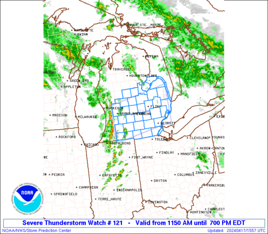
URGENT - IMMEDIATE BROADCAST REQUESTED Tornado Watch Number 121 NWS Storm Prediction Center Norman OK 130 AM CDT Wed Apr 5 2023 The NWS Storm Prediction Center has issued a * Tornado Watch for portions of Central and northern Arkansas Southern Illinois Southeastern Missouri * Effective this Wednesday morning from 130 AM until 900 AM CDT. * Primary threats include... A few tornadoes likely with a couple intense tornadoes possible Scattered large hail and isolated very large hail events to 2 inches in diameter possible Scattered damaging wind gusts to 70 mph possible SUMMARY...Thunderstorms are increasing in coverage and depth in a plume of low-level lift well ahead of the cold front, across parts of Arkansas, with additional development possible. The environment favors supercell potential and tornado risk with any convection that can root in the boundary layer on a sustained basis. The tornado watch area is approximately along and 65 statute miles east and west of a line from 70 miles south southwest of Batesville AR to 35 miles north northeast of Carbondale IL. For a complete depiction of the watch see the associated watch outline update (WOUS64 KWNS WOU1). PRECAUTIONARY/PREPAREDNESS ACTIONS... REMEMBER...A Tornado Watch means conditions are favorable for tornadoes and severe thunderstorms in and close to the watch area. Persons in these areas should be on the lookout for threatening weather conditions and listen for later statements and possible warnings. -
I'm starting to think early in the day was the 'calm before the storm'. This overnight storm does have me concerned .
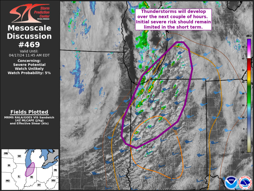
 Mesoscale Discussion 0469
   NWS Storm Prediction Center Norman OK
   0846 PM CDT Tue Apr 04 2023

   Areas affected...Northeastern Texas...south-central
   Arkansas...northwestern Louisiana

   Concerning...Severe potential...Tornado Watch likely

   Valid 050146Z - 050345Z

   Probability of Watch Issuance...80 percent

   SUMMARY...Monitoring potential tornado threat over the next few
   hours. Watch may be needed within the hour.

   DISCUSSION...A conditional tornado threat is evolving across the
   Arklatex region. Currently, a cluster of cells near the Arklatex
   region have shown evidence of deepening updrafts with increasing
   echo top heights on radar. The environment across south-central
   Arkansas and northern Louisiana is conditionally supportive of
   strong tornadoes, given sampling of 0-1 km SRH around 300-400 J/kg
   and large, curved hodographs at SHV and LZK. RAP analysis shows STP
   around 4-5 across this region over the next few hours. Should this
   line of developing storms continue to intensify, a risk for strong
   tornadoes will be possible especially if semi-discrete cells can
   become established. A watch may be needed within the hour if trends
   show continue development with increasing intensity.
-
Lowering of a wall cloud per the chaser. Nothing on the ground as of yet
-
Reed is also on something
-
Chaser has something on stream.
https://www.twitch.tv/stormchaserirl
Sounded like sirens in the background


Severe Weather 4-25 through 4-28-23
in Central/Western States
Posted