

weatherextreme
-
Posts
540 -
Joined
-
Last visited
Content Type
Profiles
Blogs
Forums
American Weather
Media Demo
Store
Gallery
Posts posted by weatherextreme
-
-
000
FXUS64 KFWD 042015
AFDFWD

Area Forecast Discussion
National Weather Service Fort Worth TX
315 PM CDT Tue Apr 4 2023

...New Long Term...

.SHORT TERM... /Issued 155 PM CDT Tue Apr 4 2023/
/Through Wednesday/

This afternoon: An isolated storm or two cannot be ruled out,
although that potential remains low. All modes of severe will be
possible if a storm does develop.

Tonight: A higher threat for severe weather will materialize.
Once again, all modes of severe weather will be possible. The
greatest threat will mainly be east of I-35, where the greatest
moisture will reside.

A deepening longwave trough continues to move eastward this early
Tuesday afternoon. Strong southerly flow beneath a strong capping
inversion is keeping partly to mostly cloudy conditions
throughout much of the region. A few convective attempts have
already occurred, but as expected, the stout capping inversion is
keeping storms at bay. Latest ACARS soundings show minimal change
to the inversion over the last several hours and generally
correlates fairly well with the forecast soundings showing a
stronger cap. A few showers beneath the cap continue to develop,
but overall, the potential for any one shower to break through the
cap is low. **IF**, however, an updraft does break the cap, large
hail, damaging winds and a tornado will all be possible.

Storm chances will briefly drop around/shortly after sunset as
surface heating gradually wanes. The next focus for additional
convective activity will be an incoming cold front, expected to
arrive around midnight within our northwestern counties. The
combination of the front and a subtle shortwave emerging out of
Mexico will lead to the rapid blossoming of thunderstorms along
the leading edge of the front. Steep mid-level lapse rates around
8 C/km, high instability and effective shear around 55 knots will
promote the development of embedded supercells capable of
producing large hail, damaging winds and a tornado or two.

As the front moves through, the thunderstorm potential will come
to an end. Our far southeastern continues will be the last to see
see the front, passing through closer to 8 am tomorrow morning.
-
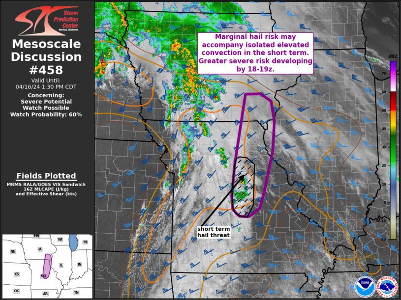
NWS Storm Prediction Center Norman OK
   0306 PM CDT Tue Apr 04 2023

   Areas affected...portions of North Texas...eastern
   Oklahoma...western Arkansas into southwestern Missouri and
   southeastern Kansas

   Concerning...Severe potential...Watch possible

   Valid 042006Z - 042200Z

   Probability of Watch Issuance...40 percent

   SUMMARY...Thunderstorms may pose a risk initially for hail across
   portions of North TX/OK into portions of western AR. Additional
   development along the dryline is possible in eastern KS and western
   MO. Uncertainty on the exact timing and location of storm
   development is very high. Trends are being monitored for a possible
   weather watch.

   DISCUSSION...As of 2000 UTC, afternoon observations showed a broad
   plume of cirrus, associated with a deep western US trough,
   overspreading a warming and moistening air mass across much of the
   ArkLaTex and southern Plains. Within the broad cirrus, several CI
   attempts have been noted along and east of a confluence band ahead
   of the dryline in North TX. Surface temperatures near 80 and
   dewpoints in the upper 60s to low 70s F are supporting moderate
   instability with MLCAPE of 2000 J/kg. With the main trough lagging
   to the west, forcing for ascent is rather nebulous over much of the
   region through the afternoon. This is evident in SPC mesoanalysis
   which shows considerable inhibition still in place below a robust
   EML. Despite the inhibition, strong flow aloft is supporting long
   elongated hodographs with effective shear of 50-60 kt favorable for
   supercells with the potential for large hail. Weaker low-level shear
   may limit the initial tornado threat if supercells are able to
   mature. However as forcing increases toward the evening, a greater
   threat for tornadoes may evolve.

   Recent visible and radar trends show several weak, likely elevated
   updrafts over the Red river are persisting despite the inhibition.
   As updrafts cluster and shift north, a more sustained/sustained
   storm may evolve from these initial attempts. Diurnal heating/weak
   ascent may also support additional, isolated development around the
   dryline from east/northeastern OK into eastern KS. Poor handling of
   the situation by Hi-res guidance and nebulous forcing lends low
   confidence in additional convective development and the overall
   evolution. None the less, the strongly sheared and destabilizing air
   mass appears conditionally favorable for large to very large hail
   and possibly tornadoes late this afternoon into the evening. A
   greater threat will likely evolve overnight as the main trough
   ejects eastward. Trends will be monitored or a possible weather
   watch this afternoon but uncertainty is high.
-
-
Looks like FWD is still looking at dryline storms and westward/southward extent of the threat for tomorrow. (Imagine isn't copying) This can be seen from the FWD NWS site.
-
 1
1
-
-
-
15 hours ago, Quincy said:
Three main areas of concern:
1. Warm sector/near the warm front from Missouri toward the Iowa/Illinois border area. Pretty good model agreement that either a cluster or perhaps just a renegade storm or two initiates. A significant severe threat would likely accompany any storms, with large CAPE, supercell wind profiles and low level hodograph enlargement.
2. Dryline from eastern Kansas into Oklahoma. With slower trough ejection modeled, convective initiation seems unlikely. Should a storm manage to form, it would very likely be severe. I think this is the least likely of the three scenarios, especially if the model trend continues.
3. A more widespread severe threat may materialize after dark as the trough ejects and the low level jet ramps up. We could see a broken line of storms move across eastern Kansas, along with cellular warm sector activity possible across the Ozarks. The only thing perhaps limiting this threat is that the main line of storms may grow upscale due to nearly boundary-parallel shear and pre-frontal activity is a bit more uncertain.
Looks like # 3 so far
DAY 2 CONVECTIVE OUTLOOK
NWS STORM PREDICTION CENTER NORMAN OK
1255 PM CDT MON APR 03 2023
VALID 041200Z - 051200Z
...THERE IS A MODERATE RISK OF SEVERE THUNDERSTORMS FROM EASTERN
IOWA INTO NORTHWEST ILLINOIS...AND FROM SOUTHERN MISSOURI
SOUTHWESTWARD TOWARD THE ARKLATEX....
..SUMMARY
A LARGE AREA OF SEVERE POTENTIAL WILL EXIST FROM TUESDAY AFTERNOON
INTO WEDNESDAY MORNING, FROM EASTERN PORTIONS OF THE PLAINS INTO THE
MISSOURI AND MID/UPPER MISSISSIPPI VALLEYS. STRONG TORNADOES AND
PARTICULARLY DAMAGING WINDS ARE EXPECTED. BOTH AFTERNOON AND
OVERNIGHT POTENTIAL WILL EXIST ACROSS VARIOUS REGIONS, INCLUDING THE
RISK OF DANGEROUS NIGHTTIME TORNADOES.
..SYNOPSIS
A LARGE UPPER TROUGH WILL MOVE FROM THE ROCKIES INTO THE PLAINS ON
TUESDAY, WITH AN UPPER LOW TRACKING FROM WY TO NORTHERN MN BY
WEDNESDAY MORNING, DEEPENING AFTER 00Z. MEANWHILE, UPPER RIDGING
WILL OCCUR OVER THE EASTERN STATES. A STRONG 100 KT MIDLEVEL JET MAX
WILL BE POSITIONED FROM NM INTO WESTERN KS DURING THE DAY, WITH AN
INTENSIFYING JET CORE TUESDAY NIGHT FROM KS INTO IA. JUST AHEAD OF
THE PRIMARY UPPER TROUGH/JET, A LEADING SPEED MAX WILL STRENGTHEN
FROM OK INTO KS AND MO DURING THE DAY, PERHAPS WITH A SUBTLE LOBE OF
COOLING ALOFT.
AT THE SURFACE, LOW PRESSURE WILL EXIST OVER EASTERN CO TUESDAY
MORNING, AND WILL SHIFT EASTWARD ACROSS KS DURING THE DAY,
TRANSLATING EAST/NORTHEAST ALONG A COLD FRONT. THIS LOW WILL SHIFT
INTO IA BY EVENING, AND INTO WI BY 12Z WEDNESDAY. AHEAD OF THE LOW,
A PROMINENT WARM FRONT WILL MOVE RAPIDLY NORTH, BEGINNING THE DAY
FROM NORTHEAST KS INTO CENTRAL IL, AND REACHING NEAR I-80 FROM IA
INTO NORTHERN IL BY 00Z. THIS BOUNDARY WILL CONTINUE NORTH INTO
SOUTHERN WI AND WESTERN LOWER MI OVERNIGHT, AHEAD OF THE SURFACE
LOW. BEHIND THE LOW, A COLD FRONT WILL MAKE AN EASTWARD PUSH DURING
THE LATE EVENING AND OVERNIGHT ACROSS IA, NORTHWEST MO AND EASTERN
KS.
SOUTH OF THE LOW, A DRYLINE WILL STRETCH FROM EASTERN KS INTO
CENTRAL OK AND NORTH TX AT 00Z, AND MAY BECOME STATIONARY OR EVEN
BACK WESTWARD OVER THE SOUTHERN PLAINS DURING THE LATE EVENING AND
PRIOR TO THE COLD FRONT ARRIVING FROM THE NORTH.
GIVEN RELATIVELY HIGH HEIGHTS OVER THE EASTERN CONUS PRECEDING THE
UPPER TROUGH, A VERY WIDE WARM SECTOR WILL DEVELOP FROM THE SURFACE
LOW AND DRYLINE EASTWARD WELL EAST OF THE MS RIVER, WITH UPPER 60S F
DEWPOINTS COMMON FROM EASTERN OK AND AR SOUTHWARD. THE COMBINATION
OF AN EXPANSIVE WARM SECTOR AND STRONG SHEAR, FOR LONG DURATION AND
IN VARIOUS FORCING REGIMES, SUGGESTS THAT SIGNIFICANT SEVERE WEATHER
IS LIKELY. HOWEVER, SUBTLETIES REGARDING TIMING WITH REGARD TO THE
DIURNAL CYCLE, CAPPING, AND CONFLICTING MODEL OUTPUT WILL MAKE THIS
PREDICTION CHALLENGING, ESPECIALLY WHEN WEIGHING POTENTIAL IMPACTS
TO LIFE AND PROPERTY.
..IA...NORTHERN MO...IL...SOUTHERN WI - DAYTIME
THE AREA NEAR THE WARM FRONT AND LATER IN LATE INTO THE OVERNIGHT
HOURS AHEAD OF THE SURFACE LOW WILL BE A FAVORED AREA FOR SUPERCELLS
AND TORNADOES. STORMS ARE EXPECTED TO FORM FROM NORTHERN MO INTO IA
DURING THE LATE AFTERNOON, SHIFTING NORTHEASTWARD WITH THE WARM.
LOW-LEVEL SHEAR WILL BE EXTREMELY FAVORABLE FOR TORNADOES, AS WITH
OVER 300 M2/S2 SRH AND MUCAPE PERHAPS UP TO 3000 J/KG. THE STEEP
LAPSE RATES ALOFT WILL MAXIMIZE UPDRAFT STRENGTH AS WELL, RESULTING
IN STRONG TORNADOES. THIS THREAT MAY PERSIST FARTHER NORTHEAST INTO
SOUTHERN WI AND NORTHERN IL INTO THE NIGHT AS THE WARM AND UNSTABLE
AIR WITH THE WARM FRONT CONTINUES TO MOVE NORTH WITH THIS STRONG
SYSTEM.
..NORTHEAST TX INTO AR AND INTO MO - OVERNIGHT
CONFIDENCE IS INCREASING IN THE POTENTIAL FOR RARE AND DANGEROUS
OVERNIGHT TORNADOES AND DAMAGING WINDS, AND A MODERATE RISK HAS BEEN
INTRODUCED FOR THIS REGION. THE AIR MASS WILL REMAIN CAPPED DURING
THE DAY, AS BOUNDARY-LAYER MOISTURE BUILDS. STEEP LAPSE RATES WILL
EXIST ABOVE THE CAPPING LAYER, WHICH WILL NOT BE PARTICULARLY STRONG
OVERNIGHT DUE TO ROBUST MOISTURE. AS THE COLD FRONT APPROACHES FROM
THE WEST, THE LOW-LEVEL JET WILL REMAIN STRONG PROVIDING THETA-E
ADVECTION THROUGH THE NIGHT. NOCTURNAL STORMS ARE FORECAST TO ERUPT
AFTER 06Z, AND PERHAPS CLOSER TO 08Z FROM SOUTHWEST MO INTO WESTERN
AR AND INTO NORTHEAST TX. HODOGRAPHS WILL STRONGLY FAVOR TORNADIC
SUPERCELLS WITH EFFECTIVE SRH NEAR 400 M2/S2. FURTHER, STEEP LAPSE
RATES ALOFT AND AMPLE INSTABILITY WILL FAVOR STRONG TORNADOES, AND A
LONG TRACKED TORNADO CANNOT BE RULED OUT. THIS APPEARS TO BE A RARE
CASE WHERE THE FRONT MAY ACT MORE LIKE A DRYLINE DURING THE
OVERNIGHT HOURS, WITH VEERING AT 850 MB BEING MORE GRADUAL. CAPPING
IS MOST LIKELY TO LIMIT THE EASTWARD EXTENT OF THE THREAT FOR
SOUTHERN AREAS NEAR LA.
..JEWELL.. 04/03/2023-
 1
1
-
-
Is it me or is the new day 2 update coming in very late : Edit. Day 2 updated
-
Added 4/3 for potential sleeper

North/Central Texas...
   Moderate to strong buoyancy and 50+ kt of deep-layer shear will
   support a conditionally favorable supercell environment along/just
   ahead of a dryline late this afternoon and early evening over parts
   of north/central TX. Near-neutral mid-level heights with minor
   downstream ridging is expected across the dryline. This area will
   also be well removed from a deepening upper trough across the
   western CONUS.

   Low-level convergence along the dryline should remain weak, but
   could be relatively maximized in the early evening across central TX
   as the dryline starts to retreat. Some 12Z convection-allowing
   models suggest a thunderstorm or two may briefly develop. However,
   uncertainty remains high regarding a particular location. Any
   sustained supercell would pose a conditional risk of all severe
   hazards, but large hail is likely if a thunderstorm can form and be
   sustained. Given the uncertainty in whether any convection will
   initiate given the negligible large-scale ascent, will maintain low
   severe probabilities with this update. But, observational and
   short-term model trends will be closely monitored for a possible
   upgrade to Slight Risk at 20Z, if warranted.
-
1
-
-
Day 2 Mod out with split 15/10% Tor. Almost a repeat of the previous outbreak

Day 2 Convective Outlook
   NWS Storm Prediction Center Norman OK
   1203 AM CDT Mon Apr 03 2023

   Valid 041200Z - 051200Z

   ...THERE IS A MODERATE RISK OF SEVERE THUNDERSTORMS LATE TUESDAY
   AFTERNOON AND EVENING ACROSS PARTS OF NORTHEASTERN MISSOURI INTO
   SOUTHEASTERN IOWA...NORTHWESTERN AND WEST CENTRAL ILLINOIS...

   ...THERE IS AN ENHANCED RISK OF SEVERE THUNDERSTORMS SURROUNDING THE
   MODERATE RISK ACROSS MUCH OF NORTHERN MISSOURI....CENTRAL AND
   EASTERN IOWA...NORTHWESTERN AND CENTRAL ILLINOIS...AS WELL AS PARTS
   OF NORTHEASTERN TEXAS...SOUTHEASTERN OKLAHOMA...MUCH OF
   ARKANSAS...INTO SOUTHERN MISSOURI...

   ...SUMMARY...
   Severe thunderstorms appear likely to develop late Tuesday afternoon
   into Tuesday night across the lower Missouri Valley into southern
   portions of the Upper Midwest, and across parts of the southeastern
   Great Plains into portions of the Mid South.  These could pose a
   risk for a few strong tornadoes, large hail and damaging wind gusts.

   ...Synopsis...
   As initially amplified mid-level ridging over the mid-latitude
   eastern Pacific gradually becomes suppressed, models indicate that
   downstream troughing will broaden from the Great Basin into the
   Mississippi Valley.  This will be lead by a vigorous short wave
   trough, which is forecast to be accompanied by continuing strong
   surface cyclogenesis from the central Great Plains into the Upper
   Midwest, and building downstream mid-level ridging across the Upper
   Ohio Valley into Ontario, as well as across the northeastern Gulf of
   Mexico into Southeast.

   An intensifying southwesterly mid/upper jet streak (including speeds
   in excess of 100 kt at 500 mb) nosing across the central Great
   Plains through Upper Midwest will contribute to strong deep-layer
   shear within the warm sector of the cyclone.  At the same time,
   intensification of southerly lower-level flow (to 50-70+ kt around
   850 mb) likely will contribute to large clockwise-curved low-level
   hodographs.  This could potentially contribute to an environment
   conducive to supercells and organizing lines or clusters capable of
   producing strong tornadoes and damaging winds, where large-scale
   forcing for ascent and thermodynamic profiles can become favorable.

   However, among a number of substantive lingering uncertainties, the
   quality of the boundary-layer moisture return from the Gulf of
   Mexico remains in question.  Due to (at least initially) relatively
   shallow boundary-layer depth, downward mixing of drier air might
   impact sizable pockets of the potentially broad warm sector through
   the day, based on model output.  Also, ahead of the mid/upper
   troughing, destabilization associated with large-scale ascent and an
   influx of high-level moisture from the subtropical Pacific may
   contribute to convective development which tends to saturate and
   stabilize lapse rates down into the mid-levels, across much of the
   Ozark Plateau into middle Mississippi Valley.  While it appears that
   this will not completely erode the capping elevated mixed-layer air,
   thickening cloud cover aloft may inhibit surface heating and
   suppress potential thunderstorm development in the absence of lift
   to overcome the inhibition.

   ...Great Plains into the Mississippi Valley...
   Both the latest NAM and Rapid Refresh appear increasingly suggestive
   that the dryline could surge east-northeastward across southwestern
   Iowa and northwestern/west central Missouri, at least above the
   surface, by mid to late afternoon, in response to the progression of
   at least one speed maximum within the mid-level flow.  Model output
   generally indicates that largest CAPE will become focused ahead of
   this feature, and south of the warm front advancing northward across
   central Iowa/northern Illinois during the late afternoon.  And the
   dryline might provide a focus for sustained discrete supercell
   development with the potential to produce strong tornadoes while
   propagating northeastward across northeastern Missouri and
   southeastern Iowa into northwestern and west central Illinois
   through early evening.

   In the wake of this activity, as the cold front begins to overtake
   the dryline and advance southeastward, various model output
   continues to suggest that the evolution of an organizing line or
   cluster of storms is possible.  This may pose a risk for large hail,
   damaging wind gusts, and perhaps a few tornadoes while propagating
   east-southeastward across the lower Missouri/middle Mississippi
   Valley vicinity into Tuesday night.

   Farther south, developments initially along the dryline and then
   ahead of the southeastward advancing cold front remain a bit more
   unclear.  However, there has been a persistent signal within the
   model output that a narrow corridor of more substantive
   boundary-layer moistening could provide a focus for enhanced severe
   weather potential by Tuesday evening.  It is possible that
   associated destabilization may become aligned with the strong
   deep-layer mean flow, possibly allowing for the evolution of one or
   two long track supercells, ahead of a developing squall line.
-
Looks like a big sporting day in DFW along with a Taylor Swift concert all starting around 6 PM central time.
-
-
From a local DFW met
Please read! There's a severe weather risk tomorrow. Please make sure you stay weather aware. Latest data tonight suggest the potential for a higher risk of severe weather than our current level 2/slight risk. If this gets updated/upgraded tonight, I will share it. #wfaaweather -
Some strong wording from FWD
National Weather Service Fort Worth TX
808 PM CDT Sat Apr 1 2023

...New Short Term, Aviation...

.SHORT TERM... /NEW/
/Tonight through Sunday Night/

Another nice evening is in store for North and Central Texas, but
this will quickly change by early Sunday morning as a potent upper
level disturbance approaches, bringing an increasing threat for
severe thunderstorms. The rest of tonight will be quiet with
passing clouds and temperatures falling into the 50s.

A stalled frontal boundary across South Texas will begin to lift
northward overnight in response to pressure falls in the Plains
ahead of the aforementioned upper disturbance. The disturbance is
currently located across southwest Arizona and will spread into
West Texas Sunday morning. Ahead of the shortwave, a surge of
Gulf moisture will overspread North Texas by midday with dewpoints
climbing into the mid 60s. Strong low/mid level warm advection
should lead to a blossoming of elevated convection late Sunday
morning into early afternoon mainly off to our northwest. Very
steep mid level lapse rates should support a severe hail risk with
this initial activity. As we get into the afternoon hours though,
a well defined warm sector will become established across much of
North Texas, characterized by strong instability (MLCAPE around
2000 J/kg) and deep layer shear. The timing of the shortwave will
be optimal as well, with the strongest synoptic forcing for ascent
overspreading North Texas during the mid afternoon to early
evening hours. This should yield a window (~between 4-8 pm) where
some potentially significant severe weather could occur across
parts of the region.

Most of the high resolution guidance is in decent agreement with
the initial elevated convection developing off to the northwest
then moving east into the early afternoon. During the afternoon,
there is an increasing potential for more discrete surface based
convection to develop across North Texas within the warm sector.
This activity should be forced at least partially by an eastward
surging dryline. The dryline should impinge on our western
counties during the mid afternoon hours and there is solid
agreement among the guidance that there will be a decent bulge on
the leading edge (Eastland/Stephens Counties) in response to a
band of stronger low/mid level westerly winds. In addition, the
lee side surface low never really ejects eastward, and remains
nearly stationary across southwest Kansas and the OK panhandle.
This results in the near surface flow across parts of North Texas
remaining backed longer than would normally be the case with a
rapidly moving system. Surface based storms appear most likely
from mid afternoon into the early evening hours and would likely
quickly become supercells given the favorable parameter space.
While large hail and damaging winds will certainly be possible,
there also appears to be an increasing threat for tornadoes,
particularly in an area from Mineral Wells to Fort Worth to
Hillsboro to Stephenville. This area east of the dryline bulge
appears to have the best combination of strong instability,
increasing deep layer shear, increasing synoptic forcing for
ascent, and is most likely to maintain a favorable low level wind
profile. It also appears to be the area least likely to have
favorable warm sector air disrupted by elevated convection.
Forecast soundings between 22-00Z show an uncapped thermal profile
with strengthening low level flow and increasingly curved
hodographs into the evening hours. 0-1 km helicity increases to
around 300 m2/s2 and the significant tornado parameter peaks
between 3-6 to the southwest of the Metroplex by 6 pm. This
favorable low level instability and shear profile suggests that
the threat for tornadoes will increase, particularly with any
discrete storms that track from west to east or slightly south of
east where they can maintain a healthy ingestion of streamwise
vorticity. We`ll continue to monitor this threat closely, but
anyone with outside interests should closely pay attention for
rapidly changing weather on Sunday.
-
SPC with the slight risk for N TX


Day 2 Convective Outlook
   NWS Storm Prediction Center Norman OK
   1223 PM CDT Sat Apr 01 2023

   Valid 021200Z - 031200Z

   ...THERE IS A SLIGHT RISK OF SEVERE THUNDERSTORMS DURING THE DAY
   ACROSS NORTH TX...

   ...SUMMARY...
   Occasional large hail, isolated damaging winds, and a couple of
   tornadoes will be possible during the day tomorrow, mainly across
   north Texas.

   ...North TX and vicinity through the day...
   In the wake of a pronounced midlevel trough now moving over the OH
   Valley/lower Great Lakes, a front will stall along the Gulf coast.
   Upstream, a shortwave trough now near northern Baja will progress
   eastward to the southern Plains tomorrow afternoon.  In response to
   the approach of this trough and increasing westerly flow across the
   Rockies, lee cyclogenesis across the southern High Plains will
   result in strengthening southerly low-level flow and northward
   moisture advection during the day across TX.  The increasing
   low-level moisture beneath the eastward extent of a elevated mixed
   layer plume will support substantial destabilization during the day
   across north TX.

   Clusters of mainly elevated storms are probable during the day in
   the zone of stronger low-level warm advection across northwest TX
   into southern OK, with sufficient MUCAPE/lapse rates for occasional
   large hail.  Farther south, there will be a few hour window of
   opportunity for supercells rooted near or at the surface within the
   southern fringe of the stronger forcing for ascent, close to the
   surface warm front around mid afternoon.  Mid-upper 60s
   boundary-layer dewpoints and surface heating in cloud breaks and
   midlevel lapse rates of 7-8 C/km will drive MLCAPE up to 1500 J/kg
   along the warm front, with sufficient deep-layer shear/hodograph
   length and low-level shear/hodograph curvature for supercells with
   all hazards.  These threats will be focused along the warm front
   from about 20-00z, with the threat for surface-based supercells
   diminishing during the evening with passage of the midlevel trough.
   Otherwise, clusters of slightly elevated storms will spread eastward
   toward northwest LA/southwest AR and slowly weaken early tomorrow
   night.
-
That watch goes to 7 AM. Woah
-
URGENT - IMMEDIATE BROADCAST REQUESTED Tornado Watch Number 101 NWS Storm Prediction Center Norman OK 1200 AM CDT Sat Apr 1 2023 The NWS Storm Prediction Center has issued a * Tornado Watch for portions of Northern Alabama Northern Mississippi Middle Tennessee * Effective this Saturday morning from Midnight until 700 AM CDT. * Primary threats include... A few tornadoes and a couple intense tornadoes likely Scattered damaging wind gusts to 70 mph likely Scattered large hail and isolated very large hail events to 2 inches in diameter possible SUMMARY...Severe thunderstorms, including a few supercells capable of strong (EF2+) tornadoes, will persist in areas previously covered by tornado watch 97 past its original expiration time. The threat also will extend farther east into more of Alabama and Tennessee overnight. The tornado watch area is approximately along and 75 statute miles east and west of a line from 20 miles south southwest of Tupelo MS to 50 miles northeast of Nashville TN. For a complete depiction of the watch see the associated watch outline update (WOUS64 KWNS -
Something going on with Brad's stream. Not sure what they are doing ( Just tuned in)
-
-
Jeff on he Tunica storm as well
-
Been mentioned thart Brett is looking at the tornado targeting the Tunica casinos
-
Couple tornado warned storms heading towards Memphis
-
Tornado emergency issued for Covington
-
-
Twin tornadoes confirmed by the met
Severe Weather 4-4-23
in Central/Western States
Posted