

Brasiluvsnow
-
Posts
1,618 -
Joined
-
Last visited
Content Type
Profiles
Blogs
Forums
American Weather
Media Demo
Store
Gallery
Posts posted by Brasiluvsnow
-
-
So much still in question with 36 hrs until game time I am sitting here in New City / Rockland County just hoping to see 2 or 3 inches out of this storm because this might easily be a rain event for folks like myself who live North n West of NYC and 20 miles North of the GW bridge,,,,,now back to the model and storm discussion
-
2 minutes ago, SI Mailman said:

Thanks and YUCK
-
-
Just now, wxman said:
0z GFS looks good to me, better that 18z for most.
as far as location similar to the Nam it is just inside the benchmark very very close
-
11 minutes ago, Stormlover74 said:
Nam colder, rgem warmer.
didn't Walt or Don say RGEM tends to overdo warm or am I making that up ?
-
I hope the NAM got few things correct including the location of the system = very close to the benchmark
-
-
Just now, MJO812 said:
Nam is nice
thats a good thing BUT still outta range no ?
-
 2
2
-
-
7 minutes ago, Franklin0529 said:
Over an inch of precip on gfs
and at hour 72 - and maybe my eyes are playing tricks on me but very very close / just inside the benchmark
-
2
-
-
Maybe I am just naive and not as knowledgeable as many of you but with 2 and a half days left so much is still undecided and on the table especially N n W . We can't live and die with each model run and I can only imagine what some of you will be posting if the guidance is more favorable for a snow later on today or tomorrow. "You have to be able to smell the rain in order to get the larger snow amounts " speaking of which has anyone seen what Bernie tweeted an hour ago
-
1
-
-
1 minute ago, vegan_edible said:
me. insomnia induced euro watching
So I'm not the Last Mohican,,,,,,,,show time here we go
-
Anyone besides me waiting on the Euro ?
-
3
-
-
is it warm,,,or is it that the track is too far N n W ? Because if this solution is off and the margin for error is 25 or 50 miles ,,I get it NOT a good look ,just sayin
-
1 minute ago, Typhoon Tip said:
Sure... there are two short waves really in contention for the Jan 7 event.
The first is being influence by the 2nd, further upstream.
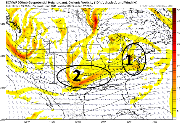
The 2nd one labeled "2" ...overtakes the lead ( complex physical interaction involving wave mechanics) and eventually subsumes the wave space, which you can see below ...
If you go any of the sites that carry these free graphics and animate the 72 thru 108 hour Euro solution from 12z, you can get a sense of how this happens in fluidity.
But ...this 102 hour chart above has captured the surface low that the original "1" triggered, and gives it a goose ( so to speak...) intensifying it further.
Thanks ,,nice job ,,,,appreciate it
-
looks more East to me at hour 90 than it did at 84 close to the benchmark but NOT there,,,,thoughts ?
-
at hour 84 ,,,,,,still looks too close for you city folks as IMO it needs be more EAST but I am sure someone else can chime in
-
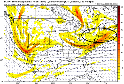
1 minute ago, Typhoon Tip said:
Haven't been in this thread -
Hey did you notice the double S/W capture scenario going on? The Euro really hits that idea hard, and sends this through a NJ model rapid deepener scenario - toward 985 mb passing SE of the Cape and clear attempt at primitive CCB into eastern southern New England. Fascinating
Can you explain this for those of us like myself who do not understand what this means ?
-
1
-
-
I want Anthony and everyone else in the 5 boroughs to get some snow but for selfish reasons I know that you " have to smell the rain in order to get the BIG snows " that said there is still a lot to be ironed out here
-
1
-
-
42 minutes ago, vegan_edible said:
gfs in a bit stronger than last night and keeps the fun going with some light-er snow all day sunday. lets hops the cmc and euro show something a little more amped and we find a happy middle ground. im hoping for a solid 5-6inches in white plains. i do wonder though since i've only lived down here for a year and half and experienced snow twice in this region, would y'all consider white plains a "coastal" area?
no
-
1 hour ago, psv88 said:
But initialization looks off?
Well played sir
-
 1
1
-
-
31 minutes ago, Rjay said:
Did I seriously read a post about initialization errors today?

it was somewhere between the Marble Rye and the Cinnamon Babka
-
2
-
 2
2
-
-
1 hour ago, SnowGoose69 said:
I have always found anytime confluence is a concern it abates sometimes on models around Day 4-6 only to start becoming a problem again inside of that. Its why I am still concerned this could move SE.
But Goose with all this Northern trends South and East would be a GOOD thing for snow lovers especially along the coast , no ? Unless you are not looking for or wanting snow ?
-
4 minutes ago, Stormlover74 said:
Sacrifice your snow blower
Can we throw snowman into a volcano ? Keeping with the thread looking forward to the overnight runs
-
1
-
-
1 hour ago, RU848789 said:
So, what do we have to do to make this happen? Damn this looks nice, even if it's 5+ days out.

Pray
Two Mdt to high impact events NYC subforum; wknd Jan 6-7 Incl OBS, and mid week Jan 9-10 (incl OBS). Total water equiv by 00z/11 general 2", possibly 6" includes snow-ice mainly interior. RVR flood potential increases Jan 10 and beyond. Damaging wind.
in New York City Metro
Posted
I hear you 85 but as Forky just pointed out this storm could easily be well N n West of both of us,,,,I hope we are both pleasantly surprised by this storm but BUST is not off the table