

RichmondTarHeel
-
Posts
818 -
Joined
-
Last visited
Content Type
Profiles
Blogs
Forums
American Weather
Media Demo
Store
Gallery
Everything posted by RichmondTarHeel
-
Jan 31st - 33rd Storm Obs and Disco like it's 1979
RichmondTarHeel replied to Bob Chill's topic in Mid Atlantic
To any cliff jumpers up there, it's not over yet. I'm rooting for y'all to get deformed (not really, I hate you all and want to move back to NoVa but houses are too damn expensive and I can make the same money in Richmond for a lot cheaper, but I'm contemplating taking a pay cut to have better snow chances.). -
Richmond Metro/Hampton Roads Discussion
RichmondTarHeel replied to RIC Airport's topic in Mid Atlantic
There's still time for us to get 2-3" of snow before we change over to rain tomorrow afternoon. This little sliver of snow coming through now is just the front edge of the storm. As the L jumps across the Appalachians and redevelops on the coast, the precip will fill in and we'll see some snow. Where it's really about to bust is up in DC, Nova and MD, where just yesterday some models were showing an historic event. -
Jan 31st - 33rd Storm Obs and Disco like it's 1979
RichmondTarHeel replied to Bob Chill's topic in Mid Atlantic
Looks like white rain -
Richmond Metro/Hampton Roads Discussion
RichmondTarHeel replied to RIC Airport's topic in Mid Atlantic
The latest model runs are all absolutely terrible. Even takes snow away from dmv folks -
Richmond Metro/Hampton Roads Discussion
RichmondTarHeel replied to RIC Airport's topic in Mid Atlantic
Well, the returns are pretty much over head. Time to go stair at the porch light till I see snow flakes. -
Richmond Metro/Hampton Roads Discussion
RichmondTarHeel replied to RIC Airport's topic in Mid Atlantic
I think it's virga, which is just being detected by the radar at Waverly, which makes it look like it's getting eat up. -
Richmond Metro/Hampton Roads Discussion
RichmondTarHeel replied to RIC Airport's topic in Mid Atlantic
I still don’t trust the models and the placement of the low. A 50 mile shift is entirely possible in any direction and can completely change the game. Also, the models tend to under estimate CAD in our area. Don’t jump yet! -
Richmond Metro/Hampton Roads Discussion
RichmondTarHeel replied to RIC Airport's topic in Mid Atlantic
Snowing all the way down around Hickory NC, with rain down through Charlotte and into South Carolina. Don’t believe the models had all that. Maybe we can over perform on the initial thump. -
Richmond Metro/Hampton Roads Discussion
RichmondTarHeel replied to RIC Airport's topic in Mid Atlantic
Yeah, at this point I’m hoping for at least 3” and am going to be pleasantly surprised by anything more. (That’s what she said) -
Richmond Metro/Hampton Roads Discussion
RichmondTarHeel replied to RIC Airport's topic in Mid Atlantic
Yeah. The Euro is no bueno. I really want in on those deform bands. Holding out hope that the models aren’t predicting the transfer correctly. -
Richmond Metro/Hampton Roads Discussion
RichmondTarHeel replied to RIC Airport's topic in Mid Atlantic
The RGEM nukes Maryland with almost 40" of snow. Not saying it's impossible, but we can probably toss that. However, it's still good to see some models showing a better L location for us and letting us get in on that Sunday. -
Richmond Metro/Hampton Roads Discussion
RichmondTarHeel replied to RIC Airport's topic in Mid Atlantic
It’s really close to being something huge. Depending on where the coastal forms and spins up, we could see a wild shift in snow totals. Glad I’m just an amateur weather lover and not a forecaster. Think you’re either going to bust really high or really low here no matter what you forecast. -
Richmond Metro/Hampton Roads Discussion
RichmondTarHeel replied to RIC Airport's topic in Mid Atlantic
Stole this from the main thread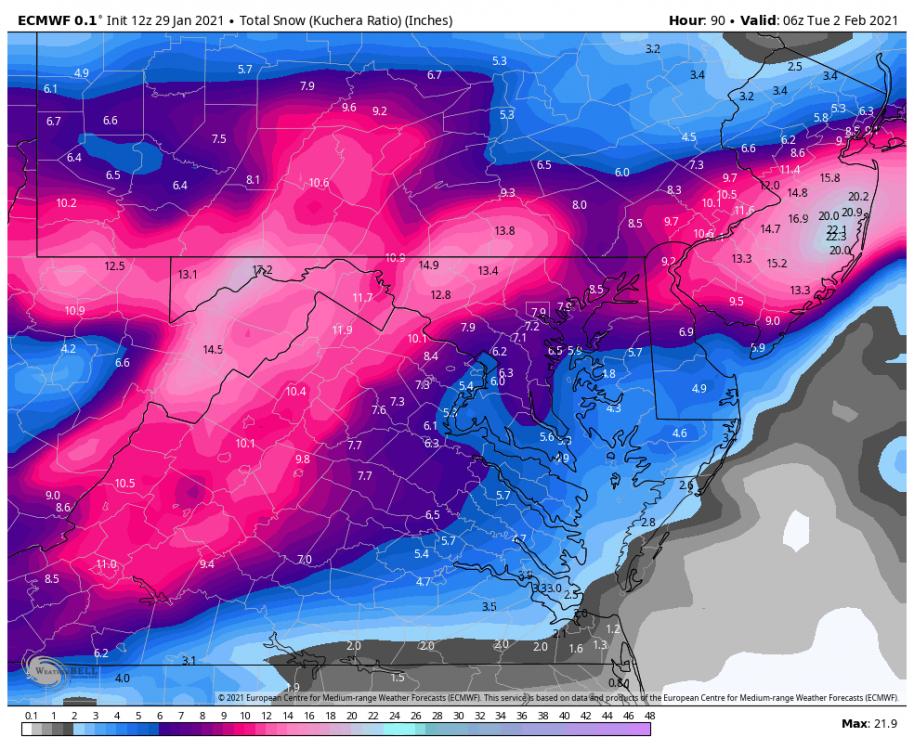
-
Richmond Metro/Hampton Roads Discussion
RichmondTarHeel replied to RIC Airport's topic in Mid Atlantic
My back porch is caving. Almost completely white. Officially the best snow of the season I think. Nice appetizer for Sunday (hopefully). -
Richmond Metro/Hampton Roads Discussion
RichmondTarHeel replied to RIC Airport's topic in Mid Atlantic
Precip inching it's way to Richmond. I'm down to 36 at my house in Midlothian. Would love to stay up late enough to see a flake or three, and hopefully wake up to a mostly white ground in the morning. -
Richmond Metro/Hampton Roads Discussion
RichmondTarHeel replied to RIC Airport's topic in Mid Atlantic
Well well, the 12z NAM 3k wants to get us a little bit of snow action tomorrow, now. -
January Storm Term Threat Discussions (Day 3 - Day 7)
RichmondTarHeel replied to WxUSAF's topic in Mid Atlantic
Any of y’all coming to Richmond to snow chase this one? -
Richmond Metro/Hampton Roads Discussion
RichmondTarHeel replied to RIC Airport's topic in Mid Atlantic
For Sunday? -
Richmond Metro/Hampton Roads Discussion
RichmondTarHeel replied to RIC Airport's topic in Mid Atlantic
The NAM doesn’t even get precip north of the VA border -
Richmond Metro/Hampton Roads Discussion
RichmondTarHeel replied to RIC Airport's topic in Mid Atlantic
I saw about 10 snow flurries today about 5pm. 2nd biggest event of the winter so far! -
Richmond Metro/Hampton Roads Discussion
RichmondTarHeel replied to RIC Airport's topic in Mid Atlantic
18z gets it up further North into VA, but misses Richmond. Idk if it's a dry slot or what, but it looks like Danville / Martinsville area gets walloped, but east of there gets nothing. https://www.tropicaltidbits.com/analysis/models/?model=nam3km®ion=neus&pkg=mslp_pcpn_frzn&runtime=2021010718&fh=1 -
Richmond Metro/Hampton Roads Discussion
RichmondTarHeel replied to RIC Airport's topic in Mid Atlantic
Richmond is about 50 - 100 miles from the bulls eye. Let's hope that thing in Maine is weaker than modeled and allows the precip to come further North. -
Richmond Metro/Hampton Roads Discussion
RichmondTarHeel replied to RIC Airport's topic in Mid Atlantic
Not giving up yet, but it is disheartening to see Chesterfield county be the cutoff on some of the overnight models. -
Richmond Metro/Hampton Roads Discussion
RichmondTarHeel replied to RIC Airport's topic in Mid Atlantic
The 18z 3k NAM, at range, is about to wallop southern VA and metro richmond. The 00z run should be interesting. -
Richmond Metro/Hampton Roads Discussion
RichmondTarHeel replied to RIC Airport's topic in Mid Atlantic
RGEM and NAM 3k look great.


