-
Posts
833 -
Joined
-
Last visited
Content Type
Profiles
Blogs
Forums
American Weather
Media Demo
Store
Gallery
Posts posted by Frog Town
-
-
1 minute ago, Jim Martin said:
Northern Indiana just issued Winter Storm Watches too.
Kind of an odd gap there in extreame ne Indiana/NW Ohio, is it not?
Ignore that.
-
9 minutes ago, geddyweather said:
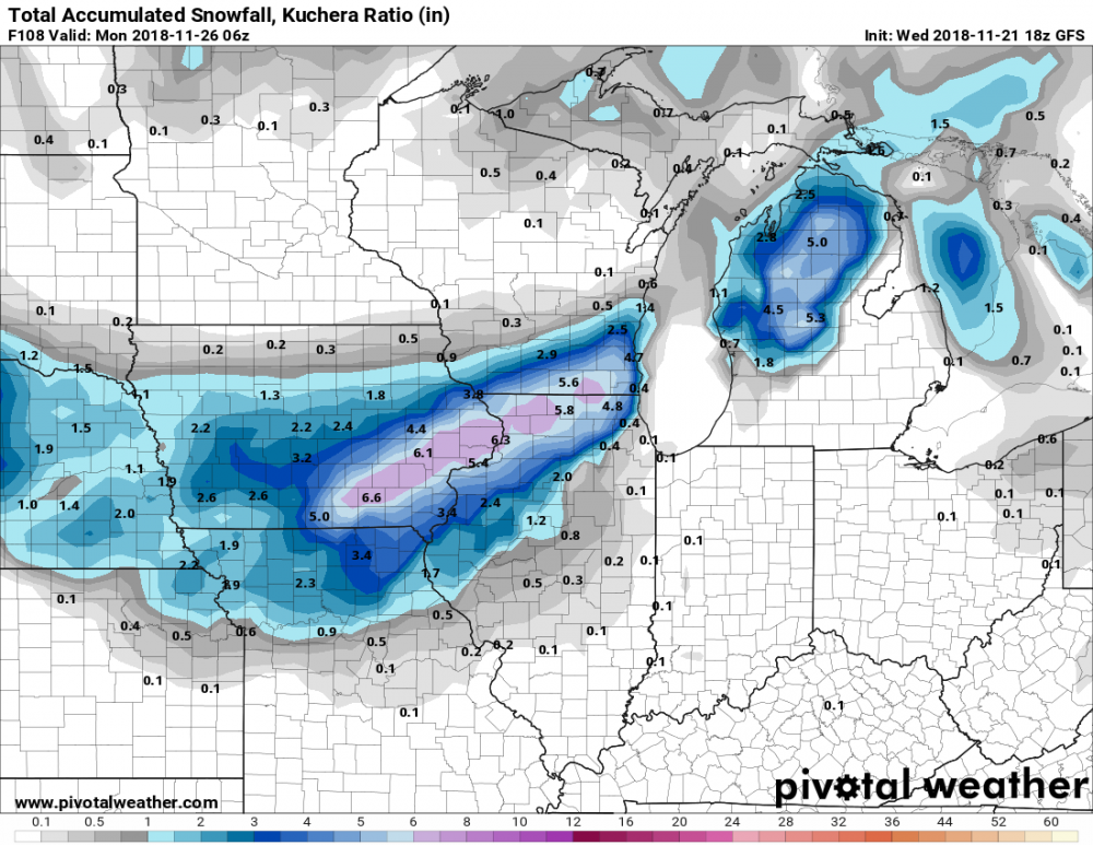
lol at that Gary, IN-Oak Harbor, OH long screw hole. Part of north central IL in there too. Fascinating feature.
Some kind of weird feedback issue on the 00Z NAM in the NW flank of the storm in the 66-80 hour range. Anyone speak to that?
-
Just now, Angrysummons said:
Maybe it is just me, but this storm seems exhausting to track.
We are just out of tracking shape, LOL.
-
 2
2
-
 2
2
-
-
Strike while the Iron is hot baby!
-
 1
1
-
-
8 hours ago, buckeye said:
Yea and there's nothing fun about that. I experienced -22 back during the Jan '94(or '95 can't recall which), super arctic outbreak. It was interesting for a day just to experience, but that's about it. I lived in a condo complex at the time and no one could go to work because their cars wouldn't start. Also, once you get down to temps that extreme, the misery index sky rockets for most people due to things like pipes freezing, car issues, heating concerns, and quite simply life-threatening cold.
It was '94. First real cold i can remember as a kid.
-
Just now, nwohweather said:
Really? Perrysburg is closing in on 3” currently
Wow! What a gradient between the two of us. Must be more dry air up here. I don't like the way the radar is starting to die out. Maybe you'll fair better. Go Yellow Jackets!
-
14 minutes ago, nwohweather said:
I think Toledo will break light accumulations. Wouldn’t be shocked if we finish at 4-5”
While I'd love to agree with you, I think 2" will be tops. I'm in Sylvania with 1.5" at 7pm and the returns are to beginning to die.
-
20 minutes ago, michsnowfreak said:
It does. Ensemble agreement is very strong for a storm of some sort.
Not only does it look to be of interest, but it starts a long stretch of interest!
-
 4
4
-
-
The Euro is best I've seen regarding temps starting around the 17th. Could this be what we all have been waiting for? Just hope it doesn't end up being suppression. Keep the storm track just south of our sub and it's game on!
-
 1
1
-
-
54 minutes ago, buckeye said:
I'm being a bit of a smartass but the subject of the pattern change suddenly showing on the models is legit.
It's nice to see this sub forum has some humanity left.
-
 1
1
-
-
February was the real torcher that winter.
Referring to '11/'12
-
 1
1
-
-
The system around the 7th/8th of January is well adverstised by the non-US models, but not so much by the GFS and others. The other thing that this system has going for it, is the period of transition to a -AO and +PNA. This is typically a good time for our sub forum.
-
 1
1
-
-
Alright! Is this what we all have been waiting for so "patiently"??
From:
000
FXUS63 KIWX 261120
AFDIWX
A sudden stratospheric warming event began over the north pole
region this week and this often sends a delayed arctic intrusion
plunging into the mid latitudes. 00z models seem to be picking up on
this with a dramatic shift to a possible arctic intrusion in
the day 7-10 period. 00z long term models have all come in very cold
for day 7 and beyond with general differences in strength and timing
of this cold air intrusion. Signal is there in most guidance and
blends with highs on New Years day or just after likely only in the
lower to middle 20s, possibly colder depending on timing. Could be a
decent lake response given increased instability but low to mid
chance pops in lake favored areas for now. Will also have to watch
closely energy ejecting out of southern jet stream. At this time,
this energy moves east just ahead of northern stream arctic
front. However, faster and more northward ejection of this feature
and its associated moisture could lend to more phasing and possible
storm system with this arctic front. Will be watching closely.
-
 1
1
-
-
Dude! Bad Ass right up!
-
Anyone else getting the feeling this "Cold" winter is going to turn into a 2 week cold period the last week of January and the first week of Feb?? This is starting to remind me of the cold chasing I did in the winter of '05-'06 and '12-'13. A little discouraged by the CPC's write up for the next 3-4 weeks. They seem to be thinking the opposite of everyone else.
-
51 minutes ago, Jebman said:
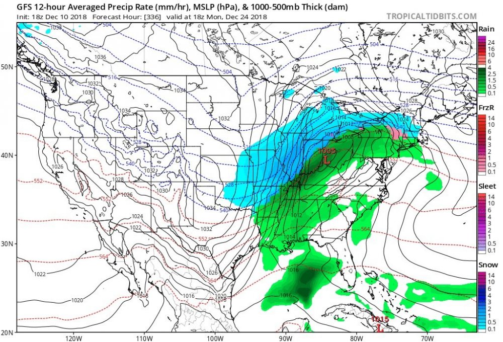
On or about Christmas Eve into Christmas Day, there is a possibility of an intense blizzard over Illinois and points north and east. Winds would be pretty strong but the snow amounts may be mammoth. Just a heads up. Should start seeing this on standard models in about a week, signal will be quite strong. 1978 anyone?
Did you happen to eat green brownies??
-
 1
1
-
 1
1
-
-
-
1 hour ago, RCNYILWX said:
I'm mildly interested in Wednesday's clipper/hybrid. Pretty stout little wave with it, along with steep mid-level lapse rates. Quickly cooling 850s shown on the models are indicative of the rapid height falls and evaporative cooling given very dry low and mid levels ahead of system.
Someone could get a surprise slushy inch or two or three *if* the wave ends up as strong as shown on recent Euro/GFS/NAM op runs. It's somewhat reminiscent to me of the fast moving burst of heavy snow this past Feb 17th. We had a very marginal air mass ahead of it but the steep lapse rates & evaporative cooling more than made up for it.
After the possible Wednesday system, late week closed low is a crap shoot and not worth trying to figure specifics yet, also any snow accums will be very thread the needle with it. Thereafter, our mild +EPO pattern should continue until about the 20th or so. At that point, ensembles are indicating the GOAK vortex retrograding to the Aleutians for classic weak Nino position allowing -EPO to build and cold to return. There's also a decent chance of -AO returning with SPV displacement/split possibly further aided by a SSW.
There could be a window for some winter fun somewhere in the sub in the runup to Christmas, with the -EPO induced downstream trough possibly dumping cold air mass into the west/Plains and sub forum and then spreading east. Euro ensemble runs have been pretty consistent with this idea toward the end of the runs the past few days and 06z GEFS also hinting at that. Way out there, but worth watching for if we can get a stronger west/southwest system before trough axis maybe shifts farther east after Christmas. The pattern will almost certainly continue to suck in general between now and about the 20th, but I'm cautiously optimistic for the last 10-11 days of the month.
sweet write up, RCNYILWX.
-
 4
4
-
-
Is this what will evolve? Cool read for those in the lower lakes
https://www.weather.gov/dtx/winter0203review
-
 1
1
-
-
21 minutes ago, CoachLB said:
Well. That high dropping in will determine the outcome. Right now looks like an I-71 corridor and south for Ohio.
Eastern Texas is typically a perfect launching spot for most of our sub. But of course a huge high has to sit in the way. Ugh
-
3 hours ago, outflow said:
With the lack of vegetation in the winter, especially leaves on trees, to impead and dampen the sound shouldn't thunder be heard better in the cold season vs warm?
The simple physics of the air molecules being more dense in colder weather would greatly amplify sound waves, allowing them to hit much harder.
-
 1
1
-
-
Did I mention the SE MI Snow Magnet is in effect?? Oh yeah, I did. It won't be official until @Hillsdale chimes in, lol.
-
 1
1
-
-
4 minutes ago, StormChaser4Life said:
Definitely a notable se trend. Gfs is obviously on the extreme end of guidance for it's southern track. But curious to see if other models keep nudging se
The Detroit Snow Magnet has begun. SE MI for the Win!
-
 1
1
-
 1
1
-
-
12 minutes ago, ILwxchr said:
It'll be over SE MI by Saturday.....Snow Magnet Activated!
-
 5
5
-


Winter Storm? Jan 18-19th, 2019
in Lakes/Ohio Valley
Posted
I'll be honest. I'd rather sit in that FGEN band and get snow for 18hrs, than get a crush job for 10 hours and watch it snow to my north. I've watched that way to many times to my north from here in NW OH. Sometimes it's not about how much you get, but the duration and steadiness of it, for me anyway.